Ness Development Brief - The Highland Council
Ness Development Brief - The Highland Council
Ness Development Brief - The Highland Council

Create successful ePaper yourself
Turn your PDF publications into a flip-book with our unique Google optimized e-Paper software.
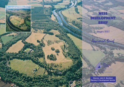
NESS<br />
DEVELOPMENT<br />
BRIEF<br />
January 2007<br />
Approved <strong>Brief</strong><br />
Director: John D. Rennilson<br />
Planning & <strong>Development</strong> Service
<strong>Ness</strong> <strong>Development</strong> <strong>Brief</strong> January 2007<br />
CONTENTS<br />
1 CONTEXT & PURPOSE<br />
2 POLICY<br />
3 DISTRICT STRUCTURE<br />
4 NEIGHBOURHOOD FRAMEWORK<br />
5 DELIVERY OF COMMON NESS CASTLE DEVELOPER<br />
CONTRIBUTIONS<br />
6 OTHER “ON SITE” NESS CASTLE DEVELOPER<br />
REQUIREMENTS<br />
Note:<br />
All Ordnance Survey Maps used in this <strong>Development</strong> <strong>Brief</strong> are the latest available at the time of<br />
production. <strong>The</strong>y may not reflect exactly what is on the ground at present, but they have not been<br />
altered in any way by the <strong>Council</strong>.<br />
<strong>The</strong> <strong>Highland</strong> <strong>Council</strong> Planning & <strong>Development</strong> Service 2 Approved <strong>Brief</strong>
<strong>Ness</strong> <strong>Development</strong> <strong>Brief</strong> January 2007<br />
1 CONTEXT & PURPOSE<br />
1.1 This <strong>Brief</strong> promotes the development of one of the City’s principal expansion<br />
areas to complete a sustainable and balanced <strong>Ness</strong> District. To do this it<br />
provides a financial protocol to co-ordinate and secure equitable developer<br />
contributions towards the additional deficiencies created by upwards of 1,300<br />
new houses and 2,700 new residents. It also specifies an optimum mix and<br />
layout of land use that will achieve this aim. Guidance for <strong>Ness</strong> Castle is<br />
sufficient to progress pending planning applications and proposals at this<br />
location whereas land at <strong>Ness</strong>-side and Milton of <strong>Ness</strong>-side will be subject to<br />
additional policy advice once key variables such as distributor road design and<br />
the scale of retail provision have been resolved.<br />
1.2 On 29 January 2007 this <strong>Brief</strong> was approved by the City of Inverness and Area<br />
Planning Committee as supplementary policy guidance, as a material planning<br />
consideration in judging relevant planning applications and as a basis for<br />
negotiating related planning agreements.<br />
2 POLICY<br />
2.1 This <strong>Brief</strong> amplifies the provisions of the Adopted Inverness Local Plan (March<br />
2006). Policy 38(iv) states:<br />
“(iv) NESS CASTLE/NESS-SIDE: 165.0 ha. of land incorporating reservation of<br />
2.0 ha. for a primary school, a substantial District Park adjacent to the River<br />
<strong>Ness</strong>, and a District Centre for which planning permission has been given for<br />
development of a 6.6 ha. site. <strong>Development</strong> of specific parts of the area will be<br />
dependent on the following:<br />
(a) <strong>Ness</strong> Castle (90.0 ha.): a distributor “loop” road, widening of Dores<br />
Road and extension of the trunk utility mains;<br />
(b) <strong>Ness</strong>-side/Milton of <strong>Ness</strong>-side (70.0 ha.): programmed/committed<br />
funding necessary to link the A82 including developer contribution;<br />
construction of part of this route concurrent with development, and<br />
extension of the trunk water and drainage main. Land at Milton of<br />
<strong>Ness</strong>-side, which could be suitable for social/leisure, tourist uses, will<br />
require widening of Dores Road as (a) above.”<br />
2.2 Attention is drawn to other relevant guidance in particular the Inverness Local<br />
Plan Policies GP4 Affordable Housing (supplemented by the <strong>Development</strong><br />
Plan Policy Guideline [DPPG]: Affordable Housing), GP5 Developer<br />
Contributions and the Designing for Sustainability in the <strong>Highland</strong>s DPPG.<br />
<strong>The</strong>se legitimise the principle of <strong>The</strong> <strong>Council</strong> securing contributions and<br />
detail delivery mechanisms. Full details are available on the <strong>Council</strong>’s website<br />
at www.highland.gov.uk/yourenvironment/planning<br />
3 DISTRICT STRUCTURE<br />
3.1 Successful integration of the completed <strong>Ness</strong> District will depend upon<br />
making effective linkages between existing and new neighbourhoods and also<br />
between the District and its City context. Map 1 schematically shows the<br />
factors affecting the development of <strong>Ness</strong> District and its relationship to the<br />
wider Inverness context.<br />
3.2 Many of the key structural decisions about land use mix and layout are<br />
already made and embodied within <strong>Council</strong> policy or are shaped by the<br />
factors shown on Map 1. Centrality, commercial visibility and accessibility all<br />
suggest that the District Centre should, as consented and allocated, be located<br />
close to the Dores Road roundabout at <strong>Ness</strong>-side. This is the most central,<br />
least severed undeveloped parcel of land within the District and is at the<br />
fulcrum of existing and proposed circulation patterns. Similarly, the allocated<br />
district employment area at Holm Mills should be reaffirmed because of the<br />
location’s commercial visibility, opportunity for improved access via a<br />
dedicated link from the Inverness Trunk Road Link and the presence of<br />
existing employment uses.<br />
<strong>The</strong> <strong>Highland</strong> <strong>Council</strong> Planning & <strong>Development</strong> Service 3 Approved <strong>Brief</strong>
!<br />
!<br />
#<br />
#<br />
!<br />
!<br />
#<br />
# # #<br />
# # #<br />
#<br />
#<br />
!<br />
%<br />
! !<br />
!<br />
!<br />
! ! ! !<br />
! ! !<br />
# # # # #<br />
! ! !<br />
!<br />
!<br />
!<br />
! ! !<br />
!<br />
!<br />
!<br />
#<br />
#<br />
#<br />
!<br />
!<br />
#<br />
!<br />
#<br />
! !<br />
! ! ! ! !<br />
!<br />
! !<br />
# #<br />
!<br />
!<br />
#<br />
! !<br />
# #<br />
! !<br />
#<br />
!<br />
MAP 1 : DISTRICT DEVELOPMENT FACTORS<br />
LEGEND<br />
City Boundary<br />
<strong>Ness</strong> District<br />
<strong>Ness</strong> Castle<br />
Holm<br />
Milton of <strong>Ness</strong>-side<br />
<strong>Ness</strong>-side<br />
Green Wedge<br />
New Community School<br />
New District Park<br />
District Centre<br />
Employment Centre<br />
Secondary School<br />
Escarpment<br />
Holm Burn<br />
Flood Risk<br />
Inverness Trunk Road Link<br />
Dores Road<br />
Neighbourhoods Centre<br />
River/Canal Corridor<br />
© Crown Copyright. <strong>The</strong> <strong>Highland</strong> <strong>Council</strong> 100023369.<br />
NESS-SIDE<br />
MILTON OF<br />
HOLM<br />
NESS-SIDE<br />
NESS CASTLE<br />
Not to Scale<br />
Map 1 - District <strong>Development</strong> Factors-approved.ai
<strong>Ness</strong> <strong>Development</strong> <strong>Brief</strong> January 2007<br />
3.3 Other factors suggest that the <strong>Ness</strong> District Park should be located adjacent to<br />
the River <strong>Ness</strong> corridor to take maximise its amenity value and also to take<br />
account of the flood plain. Similarly, the decision on the location of the<br />
District’s future primary school provision needs to take account of centrality to<br />
the completed residential neighbourhoods, proximity to associated uses, and<br />
ensuring safer routes to any site. It is suggested therefore that a new primary<br />
school should be located as indicatively identified on Map 1 at <strong>Ness</strong>-side<br />
between the Holm Burn and the consented District Centre. This location is<br />
central, well related to complementary uses such as proposed playing field<br />
provision within the District Park and well connected to existing and likely<br />
future access routes.<br />
3.4 Creating a balanced and sustainable <strong>Ness</strong> District also requires that developer<br />
contributions are secured to mitigate common deficiencies created or amplified<br />
by new development. Tables 1 and 2 set out: a list of the deficiencies common<br />
to more than one development area including <strong>Ness</strong> Castle; the applicable<br />
boundaries; how many new and existing houses could benefit directly from their<br />
resolution, and; a financial sum per new house that equals the total cost of<br />
resolving the deficiency divided by the total future housing stock.<br />
3.5 Only housing development has been quantified because <strong>Ness</strong> Castle will be<br />
almost exclusively a residential neighbourhood. Similarly, it has been assumed<br />
that only housing uses could benefit directly from - and should therefore<br />
contribute to - improved school provision and associated community facilities,<br />
the District Park, improved public transport and local distributor road provision<br />
required solely for the purposes of accessing <strong>Ness</strong> Castle as a residential<br />
neighbourhood.<br />
Table 1: Estimated Future Housing Stock<br />
Area (1)<br />
Existing<br />
Houses<br />
(2)<br />
New Houses<br />
on Allocated<br />
Land (3)<br />
New Houses on<br />
“Windfall”<br />
sites (4)<br />
Total Future<br />
Housing<br />
Stock (5)<br />
Holm 1,118 0 7 1,125<br />
<strong>Ness</strong> Castle 14 610 0 624<br />
<strong>Ness</strong>-side 12 606 0 618<br />
Milton of <strong>Ness</strong>-side 1 118 (6) 0 119<br />
Green Wedge 13 0 0 13<br />
Total <strong>Ness</strong> District 1,158 1,334 (6) 7 2,499<br />
Holm Primary 1,166 1,216 (6) 7 2,389<br />
School Catchment<br />
Inverness Royal<br />
Academy<br />
Catchment<br />
6,672 2,865 (6) 744 10,281<br />
Assumptions / Definitions<br />
(1) Areas as delineated on Map 1<br />
(2) 2006 address point data supplied by Ordnance Survey excluding nonresidential<br />
addresses and corrected for known errors<br />
(3) Capacities from Inverness Local Plan: Adopted Plan: March 2006 (or from<br />
predecessor Inverness, Culloden & Ardersier Local Plan: April 1994 where no<br />
current specific capacity stated)<br />
(4) Based on 2000-2005 average “windfall” completions per annum within IRA<br />
catchment and previously allocated land at Holme Mains. Any additional<br />
“windfall” housing units within the <strong>Ness</strong> District boundary will be required to<br />
contribute the sums specified in Table 2. Any “windfall” retail or other<br />
commercial development within <strong>Ness</strong> District will be required to provide<br />
within its boundary, or contribute the total cost of provision elsewhere within<br />
the District, additional public open space/landscaping and community facility<br />
provision in the same proportions detailed in District Centre planning consent<br />
Ref. 98/933/OUTIN.<br />
(5) Estimated future housing stocks for when <strong>Ness</strong> District is “completed”<br />
(assumed 2017)<br />
<strong>The</strong> <strong>Highland</strong> <strong>Council</strong> Planning & <strong>Development</strong> Service 5 Approved <strong>Brief</strong>
<strong>Ness</strong> <strong>Development</strong> <strong>Brief</strong> January 2007<br />
(6) It is assumed that the Milton of <strong>Ness</strong>-side area will accommodate a profit<br />
making tourism / timeshare / retirement accommodation element equivalent to<br />
118 housing units but these units will not generate any additional school pupils<br />
Table 2: Common “District” Deficiencies Requiring a <strong>Ness</strong> Castle Developer<br />
Contribution<br />
Deficiency (1) -<br />
Facility or<br />
Improvement Required<br />
Breach of Permanent<br />
Physical Capacity of<br />
High School -<br />
Permanent extension<br />
to Inverness Royal<br />
Academy<br />
Breach of Permanent<br />
Physical Capacity of<br />
Primary School, Local<br />
Plan Community<br />
Facility Requirements-<br />
2.5 ha 250 pupil New<br />
Primary School<br />
incorporating nursery<br />
provision, &<br />
community hall, library<br />
and changing facilities<br />
Applicable<br />
Area (2)<br />
Inverness<br />
Royal<br />
Academy<br />
Catchment<br />
Holm<br />
Primary<br />
School<br />
catchment<br />
Deficiency (1) -<br />
Facility or<br />
Improvement<br />
Required<br />
Estimated<br />
Total Cost (3)<br />
Applicable<br />
Future<br />
Housing<br />
Stock (4)<br />
Average<br />
Contribution<br />
per House (5)<br />
£840,000 10,281 £81.71<br />
Shortfall in Outdoor<br />
Sport and<br />
Children’s Playing<br />
Space -<br />
9 ha District Park -<br />
(incorporating 3<br />
playing fields and a<br />
Neighbourhood<br />
Equipped Area for<br />
Play [NEAP])<br />
Local Plan<br />
Requirement -<br />
1.8 km All users<br />
riverside path<br />
Safer Routes to<br />
Schools<br />
Applicable<br />
Area (2)<br />
Estimated Total<br />
Cost (3)<br />
<strong>Ness</strong> District Total £1,650,000<br />
£900,000 for<br />
District Park<br />
£100,000/ha 4ha<br />
£700,000 for<br />
additional 3PF’s<br />
within Park on<br />
4ha @<br />
£175,000/ha plus<br />
NEAP at £50,000<br />
(excluding<br />
duplicated land<br />
acquisition and<br />
other costs)<br />
<strong>Ness</strong> District<br />
£162,000 @<br />
£90/m (excluding<br />
duplicated land<br />
acquisition and<br />
other costs for<br />
section within<br />
District Park)<br />
Applicable<br />
Future<br />
Housing<br />
Stock (4)<br />
Average<br />
Contribution<br />
per House (5)<br />
2,499 £660.26<br />
2,499 £64.83<br />
<strong>Ness</strong> Castle £125,000 624 £200.32<br />
<strong>The</strong> <strong>Highland</strong> <strong>Council</strong> Planning & <strong>Development</strong> Service 6 Approved <strong>Brief</strong>
<strong>Ness</strong> <strong>Development</strong> <strong>Brief</strong> January 2007<br />
Deficiency (1) -<br />
Facility or<br />
Improvement<br />
Required<br />
Inadequate public<br />
transport<br />
provision-<br />
Temporary<br />
subsidy to allow<br />
extension of bus<br />
service into <strong>Ness</strong><br />
Castle<br />
Inadequate public<br />
transport<br />
provision-<br />
Temporary<br />
subsidy to allow<br />
increased<br />
frequency of bus<br />
service<br />
Inadequate public<br />
transport<br />
provision-<br />
Temporary<br />
subsidy to allow<br />
evening &<br />
Sunday bus<br />
service<br />
Applicable<br />
Area (2)<br />
Estimated<br />
Total Cost (3)<br />
Applicable<br />
Future<br />
Housing<br />
Stock (4)<br />
Average<br />
Contribution<br />
per House (5)<br />
<strong>Ness</strong> Castle £144,000 624 £230.77<br />
<strong>Ness</strong> District £172,000 2,499 £68.50<br />
<strong>Ness</strong> District £88,000 2,499 £35.05<br />
Inadequate road<br />
capacity –<br />
<strong>Ness</strong> Castle<br />
“shared throat”<br />
portion of<br />
internal<br />
distributor and<br />
emergency<br />
accesses<br />
Inadequate road<br />
capacity -<br />
Dores Road<br />
Distributor<br />
improvement<br />
including<br />
adequate<br />
pedestrian /cycle<br />
way and crossing<br />
provision<br />
Inadequate road<br />
capacity -<br />
Southern<br />
Distributor Road<br />
(III & IV)<br />
‘Internal’<br />
<strong>Ness</strong><br />
Castle<br />
(those<br />
properties<br />
using road<br />
as<br />
principal<br />
distributor<br />
access)<br />
“Internal”<br />
<strong>Ness</strong><br />
Castle,<br />
Milton of<br />
<strong>Ness</strong>-side<br />
and<br />
adjoining<br />
properties<br />
taking<br />
direct<br />
access<br />
from Dores<br />
Road<br />
Total<br />
£1,250,000<br />
£850,000<br />
Nominal (6)<br />
distributor<br />
length & sum -<br />
425m @<br />
£2,000/m<br />
£400,000<br />
400m for 2<br />
emergency<br />
accesses with<br />
suitable bollards<br />
@ £1,000/m<br />
£410,000<br />
Nominal (6)<br />
distributor<br />
length & sum -<br />
205m @<br />
£2,000/m<br />
(includes an<br />
estimated<br />
£100,000 for<br />
Holm Bridge<br />
widening)<br />
Area identified under Completion of<br />
SDR Phases III and IV Minute of<br />
Agreement Schedule 1 (as varied by<br />
individual s75 agreements)<br />
622 £2,009.65<br />
746 £549.60<br />
£1,321<br />
<strong>The</strong> <strong>Highland</strong> <strong>Council</strong> Planning & <strong>Development</strong> Service 7 Approved <strong>Brief</strong>
<strong>Ness</strong> <strong>Development</strong> <strong>Brief</strong> January 2007<br />
Table 2:Assumptions / Definitions<br />
(1) <strong>The</strong> deficiencies listed are only those common to two or more development<br />
areas including <strong>Ness</strong> Castle. This list does not include obligations to provide or<br />
upgrade site specific or “on-site” infrastructure and services. <strong>The</strong>se requirements<br />
will normally be secured by planning condition and/or concluded “bond” as<br />
appropriate. Specific requirements are listed in Section 6. <strong>The</strong> District Centre<br />
allocation at <strong>Ness</strong>-side is expected to incorporate the floorspace/hectarage of<br />
community, landscaping and open space uses as specified in planning consent<br />
Ref. 98/933/OUTIN. <strong>The</strong> elements should complement rather than duplicate the<br />
provision detailed in Table 2. A medical centre is a requirement specified in the<br />
Inverness Local Plan. Any deviation from this provision will require a financial<br />
contribution from the developers of the land equivalent to the total cost of the<br />
provision of the excluded facilities elsewhere within <strong>Ness</strong> District.<br />
(2) <strong>The</strong> area within which households could benefit directly from the facility or<br />
improvement.<br />
(3) Current estimate (2006 prices) of cost inclusive of land acquisition, design and<br />
other fees, construction, fitting/laying out and “life-time” maintenance unless<br />
otherwise stated. <strong>The</strong>se will be adjusted if and when more accurate information<br />
is available and for inflation in future years by using the most appropriate<br />
indices. <strong>The</strong> figures are indicative only and not binding on <strong>The</strong> <strong>Council</strong>.<br />
(4) An estimate of the total number of existing and new houses likely to be<br />
completed within the applicable area on completion of <strong>Ness</strong> District.<br />
(5) Based on an average residential unit having 100m 2 gross (all floors) floorspace.<br />
Actual contributions will vary on a pro-rata basis.<br />
(6) <strong>The</strong> design and length of acceptable distributor road improvements are still to be<br />
designed, agreed and costed.<br />
(7) In respect of the primary school element of the community school, payment will<br />
not be required until the Holm Primary School Roll has reached 90% of its<br />
permanent physical capacity. This, other things being equal will allow a two<br />
year lead in time to provide the facility. <strong>The</strong> current roll is projected to reach<br />
this figure by the 2012/13 academic year but this will depend upon the rate of<br />
development within the catchment.<br />
3.6 Other common “district-wide” deficiencies will require contribution by <strong>Ness</strong><br />
Castle developers. However, these will be the subject of separate negotiation<br />
with the relevant agency or <strong>Council</strong> service. <strong>The</strong>se will include strategic<br />
sewerage network capacity improvements negotiated with Scottish Water,<br />
negotiation with Housing Services of <strong>The</strong> <strong>Council</strong> in line with <strong>Development</strong><br />
Plan Policy Guidance: Affordable Housing and negotiation with the planning<br />
authority in line with <strong>The</strong> <strong>Council</strong>’s Guidelines for the Provision of Open<br />
Space and Play Areas within Residential <strong>Development</strong> in Inverness Area<br />
(adjusted for the District Park contribution set out in Table 2). Land at <strong>Ness</strong>side<br />
and Milton of <strong>Ness</strong>-side will be subject to additional developer<br />
contributions which will be specified in future planning advice most notably a<br />
requirement to contribute to the completion of the Inverness Trunk Road<br />
Link.<br />
3.7 Scottish Water’s preferred sewerage solution for the <strong>Brief</strong> area is to drain<br />
flows down the Holm Dell sewer to Holm Mills and then to pump them via a<br />
new rising main to Slackbuie. Land safeguards will be required for the new<br />
main and for a pumping station and storage at <strong>Ness</strong>-side.<br />
3.8 <strong>The</strong> <strong>Brief</strong> area can deliver a significant proportion of Inverness’ affordable<br />
housing requirement. <strong>The</strong> <strong>Council</strong> will require 25% of the housing to be<br />
affordable and that in accordance with the <strong>Highland</strong> Structure Plan the<br />
affordable housing should be fully integrated with the private housing. <strong>The</strong><br />
percentage split between rented and low cost home ownership should be<br />
2/3rds rented and 1/3rd low cost home ownership. <strong>The</strong> value of the affordable<br />
housing land shall be as set out in the relevant DPPG irrespective of tenure<br />
type. Landowners or developers should contact Housing Services as early as<br />
possible to discuss their affordable housing proposals to avoid any abortive<br />
work or misunderstandings over the implementation of the policy. <strong>The</strong><br />
<strong>Council</strong> will expect the provision of affordable housing to be delivered evenly<br />
over all the zoned housing sites and in line with Scottish Executive Planning<br />
Advice Note 74: Affordable Housing should be indistinguishable in terms of<br />
architectural quality or detail from the private. Affordable rented housing<br />
should be dispersed in clusters of no more that 15 units.<br />
3.9 Negotiation of individual planning applications and related agreements will<br />
take account of the effect of total development costs including contributions<br />
on the marketability and availability of allocated land. If developers can<br />
demonstrate by “open book” accounting or written confirmation from a third<br />
party utility that total costs make any particular proposal uneconomic then<br />
<strong>The</strong> <strong>Council</strong> will take account of this in determining any relevant application.<br />
<strong>The</strong> <strong>Highland</strong> <strong>Council</strong> Planning & <strong>Development</strong> Service 8 Approved <strong>Brief</strong>
MAP 2 : NEIGHBOURHOOD DEVELOPMENT FACTORS<br />
LEGEND<br />
Master Plan Boundary<br />
Main Power Lines & Buffer<br />
Annex Badger Sett<br />
Main Badger Sett<br />
Satellite Badger Sett<br />
Badger Paths<br />
Contours<br />
1:7,500<br />
0 50 100 150 200<br />
Meters<br />
1cm equals 75m<br />
Tree Preservation Order<br />
Inventory Woodland<br />
Other Amenity Woodland<br />
Foul Water Mains<br />
Water Mains<br />
Listed Building<br />
Flood Risk<br />
© Crown Copyright. <strong>The</strong> <strong>Highland</strong> <strong>Council</strong> 100023369.<br />
Map 2 - Neighbourhood <strong>Development</strong> Factors-approved.ai
#<br />
#<br />
#<br />
#<br />
#<br />
#<br />
#<br />
#<br />
#<br />
#<br />
#<br />
MAP 3 : NESS CASTLE INDICATIVE MASTER PLAN<br />
32<br />
70<br />
508<br />
1:7,500<br />
0 50 100 150 200<br />
Metres<br />
1cm equals 75m<br />
© Crown Copyright. <strong>The</strong> <strong>Highland</strong> <strong>Council</strong> 100023369.<br />
LEGEND<br />
Master Plan Boundary<br />
Dores Road Distributor<br />
"Throat" Distributor<br />
Internal Distributor<br />
Indicative Access<br />
Emergency Access<br />
Footpath Linkages<br />
Existing Uses<br />
Woodland Safeguard<br />
Public Open Space<br />
Residential<br />
70 Number of Housing Units<br />
Community / Open Space<br />
Badger Safeguard<br />
Map 3 - Indicative Master Plan-approved.ai
<strong>Ness</strong> <strong>Development</strong> <strong>Brief</strong> January 2007<br />
4 NEIGHBOURHOOD FRAMEWORK<br />
4.1 <strong>Ness</strong> Castle comprises undulating pasture land enclosed by policy plantings and<br />
other woodland. It therefore has landscape capacity to accommodate<br />
development but presents design challenges in terms of a lack of outlook and<br />
winter tree shading. As with the wider District, the pattern of safeguards and<br />
constraints shown on Map 2 shape the developable parcels of land and optimum<br />
access arrangements.<br />
4.2 Distributor road access to <strong>Ness</strong> Castle is only practicable from Dores Road. <strong>The</strong><br />
escarpment, known badger interests and woodland cover together with a<br />
requirement to take access as close as possible to the urban edge all suggest that<br />
the optimum arrangement is for a single distributor following an alignment close<br />
to that of the former <strong>Ness</strong> Castle Hotel existing driveway. An indicative<br />
alignment is shown on Map 3 which passes to the south west of the driveway so<br />
as to minimise the loss of the best policy woodland that lines it. However, this<br />
single point of access arrangement creates a requirement to minimise the length<br />
of the “throat” of the distributor before it forms a loop through the development<br />
area. It also creates a requirement to provide alternative emergency access<br />
points. Two points of access on to the Torbreck Road are shown indicatively on<br />
Map 3. Another design principle will be that a bus stop should be provided<br />
within a 400 metre walking distance of every house and this will shape the<br />
degree of penetration of the distributor loop within the development area.<br />
Within and adjoining this loop, individual housing layouts will be expected to<br />
follow a loose grid road/path pattern so that local connections between these<br />
home zones are direct and overlooked. <strong>The</strong> indicative routes shown on Map 3<br />
are <strong>The</strong> <strong>Council</strong>’s preferred access arrangements. However, they do not exclude<br />
consideration of other alternatives particularly where it can be demonstrated that<br />
the preferred route is affected by a ransom issue.<br />
4.3 In terms of the improvement to Dores Road the following guidance will apply.<br />
In the event that the flood scheme does not proceed or is delayed until after<br />
commencement of the housing development then the developers should fund the<br />
full cost of bringing the Dores Road Holm Burn bridge up to an acceptable<br />
standard including pedestrian provision. <strong>The</strong> minimum Dores Road<br />
improvement is reconstruction of Dores Road to provide a minimum 6m<br />
carriageway and a 3m footway / cycleway as far as the proposed access to the<br />
housing development. Partial improvement to service initial phases of<br />
development will not acceptable because of the current lack of any footway /<br />
cycleway provision.<br />
4.4 <strong>The</strong> Indicative Master Plan attempts to safeguard and promote positive<br />
management of as much of the woodland resource that is compatible with the<br />
development of allocated land. In particular, it suggests the consolidation of<br />
the clusters of woodland on the roundels and other raised ground. Similarly,<br />
the indicative access arrangements minimise the impact on the Tree<br />
Preservation Order and offer opportunities for its reinforcement. Other new<br />
planting should screen/enhance distributor and remote footpath corridors and<br />
be restricted to non-invasive species.<br />
4.5 Badger interests represent an uncertain element in the design framework.<br />
Survey data to date suggests that activity is concentrated on the embankment<br />
but loss of foraging land to development will be an issue. <strong>The</strong> design<br />
parameter is to sustain the social group within its current territorial boundary.<br />
Map 3 suggests that this may be possible by encouraging relocation of badger<br />
activity to the south west end of <strong>Ness</strong> Castle. Developers will be required to<br />
demonstrate the effectiveness of this proposal or any alternative they suggest.<br />
4.6 <strong>The</strong> higher ground, west of the former hotel, offers the maximum outlook and<br />
is central to the residential neighbourhood. It is therefore safeguarded for<br />
public open space or other community use. Similarly, affordable housing<br />
including sheltered provision and other higher density development should be<br />
dispersed throughout <strong>Ness</strong> Castle but at locations that maximise accessibility<br />
to public transport, to the central open space and to district-wide facilities at<br />
<strong>Ness</strong>-side. Phasing of development will be expected in parallel with the<br />
provision of supporting infrastructure. At <strong>Ness</strong> Castle this will equate to<br />
phasing in accordance with completion of each section on the internal<br />
distributor and related infrastructure.<br />
<strong>The</strong> <strong>Highland</strong> <strong>Council</strong> Planning & <strong>Development</strong> Service 11 Approved <strong>Brief</strong>
<strong>Ness</strong> <strong>Development</strong> <strong>Brief</strong> January 2007<br />
5 DELIVERY OF COMMON NESS CASTLE DEVELOPER<br />
CONTRIBUTIONS<br />
5.1 Table 3 summarises the total contributions likely to be generated by allocated<br />
land at <strong>Ness</strong> Castle split by current landownership.<br />
Table 3: Common <strong>Ness</strong> Castle Developer Contributions By <strong>Development</strong> Site<br />
Site Ref Owner Capacity &<br />
Contribution/unit (1)<br />
Total Common<br />
Deficiency Contribution<br />
(1)<br />
1 Rapson/Daly 32 x £8,838.27 £282,824.64<br />
2 MacRae 70 x £8,838.27 £618,678.90<br />
3 Tyser Trust 508 x £8,838.27 £4,489,841.10<br />
Total £5,391,344.60<br />
(1) Based on an average residential unit having 100m 2 gross (all floors)<br />
floorspace. Actual contributions will vary on a pro-rata basis according to the<br />
floorspace consented.<br />
5.2 Any “windfall” housing in excess of these capacities within <strong>Ness</strong> Castle will<br />
require an equal contribution per unit. Any other commercial or profit making<br />
“windfall” development other than a neighbourhood shop within <strong>Ness</strong> Castle,<br />
will be required to provide within its boundary, or contribute the total cost of<br />
provision elsewhere within <strong>Ness</strong> District, additional public open<br />
space/landscaping and community facility provision in the same proportions<br />
detailed in District Centre planning consent Ref. 98/933/OUTIN. Extension or<br />
change of use applications will be judged on the net additional residential<br />
floorspace created. <strong>The</strong>re will be no contribution for a development creating less<br />
than a total of 100m 2 gross (all floors) net additional floorspace.<br />
5.3 Contributions will be secured by the signing of individual planning agreements<br />
with developers/proprietors in the context of each grant of an applicable<br />
planning permission within <strong>Ness</strong> Castle. It is intended that the main clauses of<br />
the agreements would:<br />
<br />
<br />
<br />
<br />
<br />
<br />
prevent development being occupied in advance of payments being<br />
made to <strong>The</strong> <strong>Council</strong>;<br />
as a general principle, require payment on completion of development<br />
or completion of each phase of development identified under the<br />
terms of any grant of planning permission but would allow for<br />
alternative payment methods such as partially or fully capitalised<br />
upfront payment upfront;<br />
allow for reimbursement of contributions including interest accrued<br />
should the facility or improvement for which they have been paid not<br />
be provided within a timescale stipulated in an agreement;<br />
set a time limit by which developers/proprietors are expected to carry<br />
out their development and thus to make contributions;<br />
provide for independent arbitration;<br />
provide for registration in the Sasines or Land Registers, as the case<br />
may be, so that the agreement would be binding upon successors in<br />
title.<br />
5.4 It will be for <strong>The</strong> <strong>Council</strong> to identify from its own capital programme or other<br />
sources, the funding required for that proportion of the total cost of the facility<br />
or improvement attributable to the existing housing stock. <strong>The</strong> <strong>Council</strong> will<br />
monitor the aggregation of developer contribution monies over time to<br />
programme its contribution.<br />
5.5 Direct developer provision of the facility or improvement may be appropriate<br />
in particular for the distributor road improvements. An agreed cost for such<br />
provision would then be deducted from that developer’s contributions.<br />
Similarly, developer or third party private maintenance arrangements will be<br />
an acceptable alternative for facilities.<br />
5.6 <strong>The</strong> timings of payments will be subject to negotiation through individual<br />
applications / planning agreements but in respect of the primary school<br />
element of the community school, payment will not be required until the<br />
Holm Primary School Roll has reached 90% of its permanent physical<br />
capacity. This, other things being equal will allow a two year lead in time to<br />
provide the facility. <strong>The</strong> current roll is projected to reach this figure by the<br />
2012/13 academic year.<br />
<strong>The</strong> <strong>Highland</strong> <strong>Council</strong> Planning & <strong>Development</strong> Service 12 Approved <strong>Brief</strong>
<strong>Ness</strong> <strong>Development</strong> <strong>Brief</strong> January 2007<br />
6 OTHER “ON SITE” NESS CASTLE DEVELOPER<br />
REQUIREMENTS<br />
6.1 Additional, standard, “on-site” developer requirements will occur in the<br />
consideration of individual planning applications. <strong>The</strong> <strong>Council</strong> will expect these<br />
developer obligations to be implemented as an integral part of development<br />
proposals subject to planning permission, including through conditions and/or<br />
concluded “bond” as appropriate. At <strong>Ness</strong> Castle, these will include<br />
requirements, where relevant to:<br />
<br />
<br />
<br />
<br />
<br />
<br />
<br />
<br />
<br />
<br />
safeguard from alternative development and preserve maintenance<br />
access to the land required in connection with <strong>The</strong> <strong>Highland</strong> <strong>Council</strong><br />
(South West Inverness Flood Relief Channel) Flood Prevention Scheme<br />
2006;<br />
produce a Badger Protection Plan including any necessary mitigation;<br />
produce a similar report in respect of any other protected species such as<br />
otters, bats, barn owls and red squirrels;<br />
produce a Green Transport (or Travel) Plan;<br />
safeguard from development the routes of the informal remote footpaths<br />
shown on Map 3;<br />
produce a comprehensive landscape management plan including<br />
woodland safeguards, set-back, and details of felling and replanting;<br />
follow the pattern of land use as shown on Map 3: <strong>Ness</strong> Castle<br />
Indicative Master Plan including reservation of a 1.5ha. site for public<br />
open space or community use such as a neighbourhood shop. This<br />
would include a presumption against piecemeal development that would<br />
undermine this arrangement;<br />
provide on-site road (including contiguous foot/cycle ways, crossing<br />
facilities and bus lay-by/stop/shelter provision) water, sewerage, and<br />
segregated household waste recycling;<br />
provide SUDS measures in accordance with technical guidance in<br />
CIRIA manual C521 for the disposal of surface water. Developers will<br />
be expected to present and design SUDS measures on a strategic basis.<br />
Measures should also maintain and enhance where possible the<br />
ecological value of waterbodies;<br />
provide incidental landscaping;<br />
<br />
<br />
<br />
<br />
<br />
<br />
provide “on-site” open space and play area provision in accordance<br />
with <strong>The</strong> <strong>Council</strong>’s Guidelines for the Provision of Open Space and<br />
Play Areas within Residential <strong>Development</strong> in Inverness Area;<br />
provide an archaeological evaluation and any necessary mitigation;<br />
produce an assessment of any development affecting the Category B<br />
listed former hotel at <strong>Ness</strong> Castle, its associated structures and their<br />
setting including any necessary mitigation;<br />
produce a flood risk assessment for any non-householder application<br />
that includes development on land within the published SEPA 1 in<br />
200 year flood risk contour;<br />
connect to the public sewerage system;<br />
convey the land or wayleaves to the boundary of the adjoining<br />
landholding required for infrastructure or services at nil cost to <strong>The</strong><br />
<strong>Council</strong> or other appropriate agency. This is to secure timeous<br />
development of the whole of <strong>Ness</strong> Castle and avoid any “ransoming”<br />
of land or related access.<br />
<strong>The</strong> <strong>Highland</strong> <strong>Council</strong> Planning & <strong>Development</strong> Service 13 Approved <strong>Brief</strong>