Developing an Equatorial Earth Observation Satellite System
Developing an Equatorial Earth Observation Satellite System
Developing an Equatorial Earth Observation Satellite System

You also want an ePaper? Increase the reach of your titles
YUMPU automatically turns print PDFs into web optimized ePapers that Google loves.
National Institute of Aeronautics <strong>an</strong>d Space – LAPAN<br />
Indonesia<br />
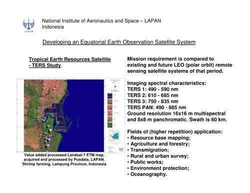
<strong>Developing</strong> <strong>an</strong> <strong>Equatorial</strong> <strong>Earth</strong> <strong>Observation</strong> <strong>Satellite</strong> <strong>System</strong><br />
Tropical <strong>Earth</strong> Resources <strong>Satellite</strong><br />
- TERS Study.<br />
Mission requirement is compared to<br />
existing <strong>an</strong>d future LEO (polar orbit) remote<br />
sensing satellite systems of that period.<br />
Imaging spectral characteristics:<br />
TERS 1: 490 - 590 nm<br />
TERS 2: 610 - 685 nm<br />
TERS 3: 750 - 835 nm<br />
TERS PAN: 490 - 685 nm<br />
Ground resolution 16x16 m multispectral<br />
<strong>an</strong>d 8x8 m p<strong>an</strong>chromatic. Swath is 60 km.<br />
Value added processed L<strong>an</strong>dsat-7 ETM map,<br />
acquired <strong>an</strong>d processed by Pusdata, LAPAN.<br />
Shrimp farming, Lampung Province, Indonesia<br />
Fields of (higher repetition) application:<br />
• Resource base mapping;<br />
• Agriculture <strong>an</strong>d forestry;<br />
• Tr<strong>an</strong>smigration;<br />
• Rural <strong>an</strong>d urb<strong>an</strong> survey;<br />
• Public works;<br />
• Environment protection;<br />
• Oce<strong>an</strong>ography.