Popular Rustic Wedding Venues on the AuSable ... - State of Michigan
Popular Rustic Wedding Venues on the AuSable ... - State of Michigan
Popular Rustic Wedding Venues on the AuSable ... - State of Michigan

You also want an ePaper? Increase the reach of your titles
YUMPU automatically turns print PDFs into web optimized ePapers that Google loves.
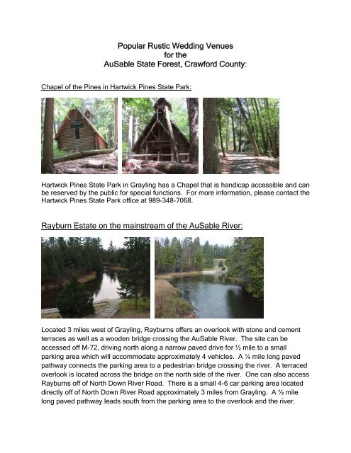
<str<strong>on</strong>g>Popular</str<strong>on</strong>g> <str<strong>on</strong>g>Rustic</str<strong>on</strong>g> <str<strong>on</strong>g>Wedding</str<strong>on</strong>g> <str<strong>on</strong>g>Venues</str<strong>on</strong>g> <br />
for <strong>the</strong> <br />
<strong>AuSable</strong> <strong>State</strong> Forest, Crawford County: <br />
Chapel <strong>of</strong> <strong>the</strong> Pines in Hartwick Pines <strong>State</strong> Park:<br />
Hartwick Pines <strong>State</strong> Park in Grayling has a Chapel that is handicap accessible and can<br />
be reserved by <strong>the</strong> public for special functi<strong>on</strong>s. For more informati<strong>on</strong>, please c<strong>on</strong>tact <strong>the</strong><br />
Hartwick Pines <strong>State</strong> Park <strong>of</strong>fice at 989-348-7068.<br />
Rayburn Estate <strong>on</strong> <strong>the</strong> mainstream <strong>of</strong> <strong>the</strong> <strong>AuSable</strong> River:<br />
Located 3 miles west <strong>of</strong> Grayling, Rayburns <strong>of</strong>fers an overlook with st<strong>on</strong>e and cement<br />
terraces as well as a wooden bridge crossing <strong>the</strong> <strong>AuSable</strong> River. The site can be<br />
accessed <strong>of</strong>f M-72, driving north al<strong>on</strong>g a narrow paved drive for ½ mile to a small<br />
parking area which will accommodate approximately 4 vehicles. A ¼ mile l<strong>on</strong>g paved<br />
pathway c<strong>on</strong>nects <strong>the</strong> parking area to a pedestrian bridge crossing <strong>the</strong> river. A terraced<br />
overlook is located across <strong>the</strong> bridge <strong>on</strong> <strong>the</strong> north side <strong>of</strong> <strong>the</strong> river. One can also access<br />
Rayburns <strong>of</strong>f <strong>of</strong> North Down River Road. There is a small 4-6 car parking area located<br />
directly <strong>of</strong>f <strong>of</strong> North Down River Road approximately 3 miles from Grayling. A ½ mile<br />
l<strong>on</strong>g paved pathway leads south from <strong>the</strong> parking area to <strong>the</strong> overlook and <strong>the</strong> river.
There is no charge to use <strong>the</strong> site for weddings under <strong>the</strong> following c<strong>on</strong>diti<strong>on</strong>s:<br />
• We do not reserve <strong>the</strong> site or <strong>of</strong>fer exclusive use <strong>of</strong> <strong>the</strong> site. The site is open to<br />
<strong>the</strong> public at all times, so you may have canoers, hikers, and o<strong>the</strong>r visitors <strong>on</strong> site<br />
during your wedding.<br />
• The wedding party and all guests are required to walk, just as <strong>the</strong> public does.<br />
• The site is for rustic minimalist use <strong>on</strong>ly. There is to be no use <strong>of</strong> sound systems,<br />
set up <strong>of</strong> tents and mini bars, or use <strong>of</strong> commercial vendors <strong>on</strong> site.<br />
• The bridge and pathway cannot be blocked and must be kept accessible at all<br />
times.<br />
• For more informati<strong>on</strong>, c<strong>on</strong>tact <strong>the</strong> Manager at <strong>the</strong> Grayling Forest Management<br />
Unit at 989-348-6371, extensi<strong>on</strong> 7440 .<br />
Mas<strong>on</strong> Chapel:<br />
George Mas<strong>on</strong> dedicated funds to c<strong>on</strong>struct a chapel al<strong>on</strong>g <strong>the</strong> <strong>AuSable</strong> River to<br />
provide fishermen with a place <strong>of</strong> reverence. The Chapel was c<strong>on</strong>structed <strong>on</strong> <strong>the</strong> east<br />
side <strong>of</strong> <strong>the</strong> <strong>AuSable</strong> River in 1960 and is open to <strong>the</strong> public.<br />
• No reservati<strong>on</strong>s are taken for <strong>the</strong> Chapel. The facility is open to <strong>the</strong> public at all<br />
times, even when in use by ano<strong>the</strong>r party.<br />
• No fees are charged.<br />
• There is <strong>on</strong>ly foot access to <strong>the</strong> Chapel. We do not unlock <strong>the</strong> gate across <strong>the</strong><br />
trail that leads from <strong>the</strong> parking area to <strong>the</strong> Mas<strong>on</strong> Tract Chapel for public use.<br />
Land access is al<strong>on</strong>g an unpaved trail with an up-hill climb. It is not handicap<br />
accessible and may not be easy for individuals with walking limitati<strong>on</strong>s (i.e. cane<br />
or walker or limited mobility i.e. wheelchair). Water access is available but<br />
requires traversing a steep stairway.<br />
• No running water is available at <strong>the</strong> Mas<strong>on</strong> Tract Chapel.<br />
• Pit toilets are at <strong>the</strong> site.
Additi<strong>on</strong>al questi<strong>on</strong>s can be directed to <strong>the</strong> Manager <strong>of</strong> <strong>the</strong> Grayling Unit at<br />
(989) 348-6371, extensi<strong>on</strong> 7440.<br />
Access to <strong>the</strong> Mas<strong>on</strong> Tract Chapel is via roads as shown <strong>on</strong> <strong>the</strong> attached<br />
map or by canoe via <strong>the</strong> <strong>AuSable</strong> River.<br />
Driving directi<strong>on</strong>s:<br />
1. M-18 east to Chase Bridge Road<br />
2. North <strong>on</strong> Chase Bridge Road <strong>on</strong>e mile to Pi<strong>on</strong>eer Road<br />
3. East <strong>on</strong> Pi<strong>on</strong>eer Road <strong>on</strong>e mile to Leline Road<br />
4. North <strong>on</strong> Leline Road <strong>on</strong>e mile to Hickey Creek Road<br />
5. East <strong>on</strong> Hickey Creek Road for 3.5 miles to Forester Road<br />
6. North <strong>on</strong> Forester Road 1.9 miles to Forest Service Road #4209<br />
7. West <strong>on</strong> Forest Service Road #4209 1.9 miles to locked gate.<br />
8. From locked gate, follow existing footpath/trail 997 feet to <strong>the</strong> Chapel.<br />
See below for a map.