Land Cover Classification of Remotely Sensed Satellite Data using ...
Land Cover Classification of Remotely Sensed Satellite Data using ...
Land Cover Classification of Remotely Sensed Satellite Data using ...

You also want an ePaper? Increase the reach of your titles
YUMPU automatically turns print PDFs into web optimized ePapers that Google loves.
International Journal <strong>of</strong> Computer Applications (0975 – 8887)<br />
Volume 7– No.11, October 2010<br />
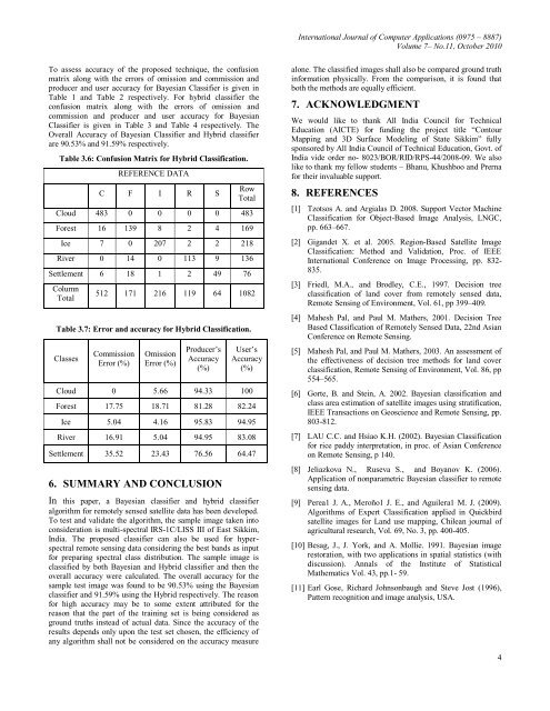
To assess accuracy <strong>of</strong> the proposed technique, the confusion<br />
matrix along with the errors <strong>of</strong> omission and commission and<br />
producer and user accuracy for Bayesian Classifier is given in<br />
Table 1 and Table 2 respectively. For hybrid classifier the<br />
confusion matrix along with the errors <strong>of</strong> omission and<br />
commission and producer and user accuracy for Bayesian<br />
Classifier is given in Table 3 and Table 4 respectively. The<br />
Overall Accuracy <strong>of</strong> Bayesian Classifier and Hybrid classifier<br />
are 90.53% and 91.59% respectively.<br />
Table 3.6: Confusion Matrix for Hybrid <strong>Classification</strong>.<br />
REFERENCE DATA<br />
C F I R S<br />
Row<br />
Total<br />
Cloud 483 0 0 0 0 483<br />
Forest 16 139 8 2 4 169<br />
Ice 7 0 207 2 2 218<br />
River 0 14 0 113 9 136<br />
Settlement 6 18 1 2 49 76<br />
Column<br />
Total<br />
512 171 216 119 64 1082<br />
Table 3.7: Error and accuracy for Hybrid <strong>Classification</strong>.<br />
Classes<br />
Commission<br />
Error (%)<br />
Omission<br />
Error (%)<br />
Producer’s<br />
Accuracy<br />
(%)<br />
User’s<br />
Accuracy<br />
(%)<br />
Cloud 0 5.66 94.33 100<br />
Forest 17.75 18.71 81.28 82.24<br />
Ice 5.04 4.16 95.83 94.95<br />
River 16.91 5.04 94.95 83.08<br />
Settlement 35.52 23.43 76.56 64.47<br />
6. SUMMARY AND CONCLUSION<br />
In this paper, a Bayesian classifier and hybrid classifier<br />
algorithm for remotely sensed satellite data has been developed.<br />
To test and validate the algorithm, the sample image taken into<br />
consideration is multi-spectral IRS-1C/LISS III <strong>of</strong> East Sikkim,<br />
India. The proposed classifier can also be used for hyperspectral<br />
remote sensing data considering the best bands as input<br />
for preparing spectral class distribution. The sample image is<br />
classified by both Bayesian and Hybrid classifier and then the<br />
overall accuracy were calculated. The overall accuracy for the<br />
sample test image was found to be 90.53% <strong>using</strong> the Bayesian<br />
classifier and 91.59% <strong>using</strong> the Hybrid respectively. The reason<br />
for high accuracy may be to some extent attributed for the<br />
reason that the part <strong>of</strong> the training set is being considered as<br />
ground truths instead <strong>of</strong> actual data. Since the accuracy <strong>of</strong> the<br />
results depends only upon the test set chosen, the efficiency <strong>of</strong><br />
any algorithm shall not be considered on the accuracy measure<br />
alone. The classified images shall also be compared ground truth<br />
information physically. From the comparison, it is found that<br />
both the methods are equally efficient.<br />
7. ACKNOWLEDGMENT<br />
We would like to thank All India Council for Technical<br />
Education (AICTE) for funding the project title “Contour<br />
Mapping and 3D Surface Modeling <strong>of</strong> State Sikkim” fully<br />
sponsored by All India Council <strong>of</strong> Technical Education, Govt. <strong>of</strong><br />
India vide order no- 8023/BOR/RID/RPS-44/2008-09. We also<br />
like to thank my fellow students – Bhanu, Khushboo and Prerna<br />
for their invaluable support.<br />
8. REFERENCES<br />
[1] Tzotsos A. and Argialas D. 2008. Support Vector Machine<br />
<strong>Classification</strong> for Object-Based Image Analysis, LNGC,<br />
pp. 663–667.<br />
[2] Gigandet X. et al. 2005. Region-Based <strong>Satellite</strong> Image<br />
<strong>Classification</strong>: Method and Validation, Proc. <strong>of</strong> IEEE<br />
International Conference on Image Processing, pp. 832-<br />
835.<br />
[3] Friedl, M.A., and Brodley, C.E., 1997. Decision tree<br />
classification <strong>of</strong> land cover from remotely sensed data,<br />
Remote Sensing <strong>of</strong> Environment, Vol. 61, pp 399–409.<br />
[4] Mahesh Pal, and Paul M. Mathers, 2001. Decision Tree<br />
Based <strong>Classification</strong> <strong>of</strong> <strong>Remotely</strong> <strong>Sensed</strong> <strong>Data</strong>, 22nd Asian<br />
Conference on Remote Sensing.<br />
[5] Mahesh Pal, and Paul M. Mathers, 2003. An assessment <strong>of</strong><br />
the effectiveness <strong>of</strong> decision tree methods for land cover<br />
classification, Remote Sensing <strong>of</strong> Environment, Vol. 86, pp<br />
554–565.<br />
[6] Gorte, B. and Stein, A. 2002. Bayesian classification and<br />
class area estimation <strong>of</strong> satellite images <strong>using</strong> stratification,<br />
IEEE Transactions on Geoscience and Remote Sensing, pp.<br />
803-812.<br />
[7] LAU C.C. and Hsiao K.H. (2002). Bayesian <strong>Classification</strong><br />
for rice paddy interpretation, in proc. <strong>of</strong> Asian Conference<br />
on Remote Sensing, p 140.<br />
[8] Jeliazkova N., Ruseva S., and Boyanov K. (2006).<br />
Application <strong>of</strong> nonparametric Bayesian classifier to remote<br />
sensing data.<br />
[9] Perea1 J. A., Meroño1 J. E., and Aguilera1 M. J. (2009).<br />
Algorithms <strong>of</strong> Expert <strong>Classification</strong> applied in Quickbird<br />
satellite images for <strong>Land</strong> use mapping, Chilean journal <strong>of</strong><br />
agricultural research, Vol. 69, No. 3, pp. 400-405.<br />
[10] Besag, J., J. York, and A. Mollie. 1991. Bayesian image<br />
restoration, with two applications in spatial statistics (with<br />
discussion). Annals <strong>of</strong> the Institute <strong>of</strong> Statistical<br />
Mathematics Vol. 43, pp.1- 59.<br />
[11] Earl Gose, Richard Johnsonbaugh and Steve Jost (1996),<br />
Pattern recognition and image analysis, USA.<br />
4