Antiquariat Daša Pahor
Antiquariat Daša Pahor
Antiquariat Daša Pahor

Create successful ePaper yourself
Turn your PDF publications into a flip-book with our unique Google optimized e-Paper software.
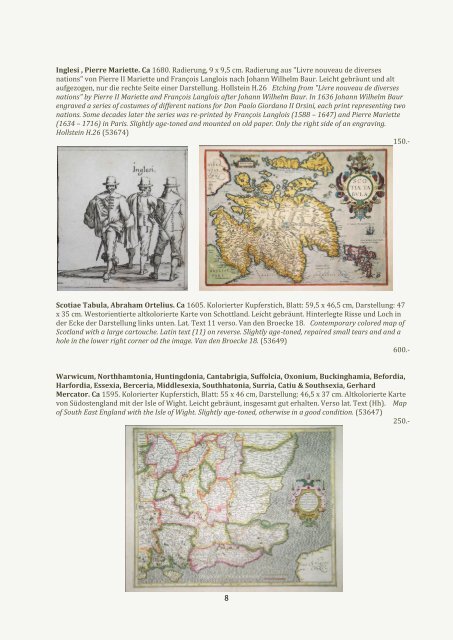
Inglesi , Pierre Mariette. Ca 1680. Radierung, 9 x 9,5 cm. Radierung aus "Livre nouveau de diverses<br />
nations" von Pierre II Mariette und François Langlois nach Johann Wilhelm Baur. Leicht gebräunt und alt<br />
aufgezogen, nur die rechte Seite einer Darstellung. Hollstein H.26 Etching from "Livre nouveau de diverses<br />
nations" by Pierre II Mariette and François Langlois after Johann Wilhelm Baur. In 1636 Johann Wilhelm Baur<br />
engraved a series of costumes of different nations for Don Paolo Giordano II Orsini, each print representing two<br />
nations. Some decades later the series was re-printed by François Langlois (1588 – 1647) and Pierre Mariette<br />
(1634 – 1716) in Paris. Slightly age-toned and mounted on old paper. Only the right side of an engraving.<br />
Hollstein H.26 (53674)<br />
150.-<br />
Scotiae Tabula, Abraham Ortelius. Ca 1605. Kolorierter Kupferstich, Blatt: 59,5 x 46,5 cm, Darstellung: 47<br />
x 35 cm. Westorientierte altkolorierte Karte von Schottland. Leicht gebräunt. Hinterlegte Risse und Loch in<br />
der Ecke der Darstellung links unten. Lat. Text 11 verso. Van den Broecke 18. Contemporary colored map of<br />
Scotland with a large cartouche. Latin text (11) on reverse. Slightly age-toned, repaired small tears and and a<br />
hole in the lower right corner od the image. Van den Broecke 18. (53649)<br />
600.-<br />
Warwicum, Northhamtonia, Huntingdonia, Cantabrigia, Suffolcia, Oxonium, Buckinghamia, Befordia,<br />
Harfordia, Essexia, Berceria, Middlesexia, Southhatonia, Surria, Catiu & Southsexia, Gerhard<br />
Mercator. Ca 1595. Kolorierter Kupferstich, Blatt: 55 x 46 cm, Darstellung: 46,5 x 37 cm. Altkolorierte Karte<br />
von Südostengland mit der Isle of Wight. Leicht gebräunt, insgesamt gut erhalten. Verso lat. Text (Hh). Map<br />
of South East England with the Isle of Wight. Slightly age-toned, otherwise in a good condition. (53647)<br />
250.-<br />
8