application of remote sensing and gis for flood risk analysis: a case ...
application of remote sensing and gis for flood risk analysis: a case ...
application of remote sensing and gis for flood risk analysis: a case ...

You also want an ePaper? Increase the reach of your titles
YUMPU automatically turns print PDFs into web optimized ePapers that Google loves.
IRJC<br />
International Journal <strong>of</strong> Social Science & Interdisciplinary Research<br />
Vol.1 Issue 11, November 2012, ISSN 2277 3630<br />
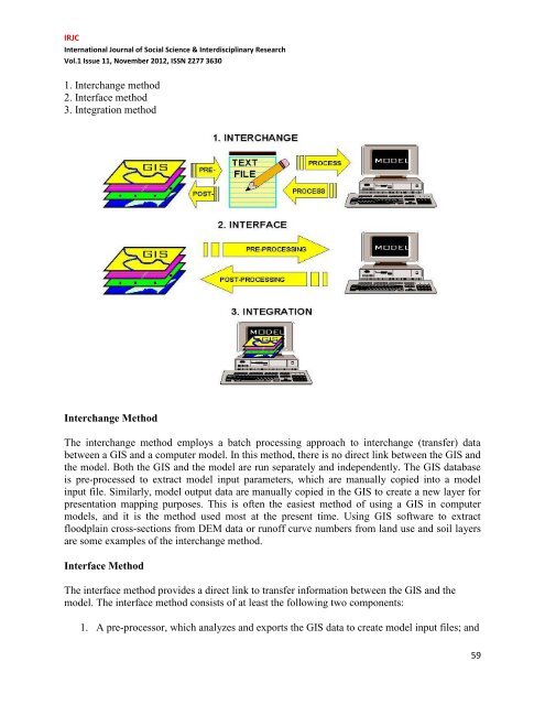
1. Interchange method<br />
2. Interface method<br />
3. Integration method<br />
Interchange Method<br />
The interchange method employs a batch processing approach to interchange (transfer) data<br />
between a GIS <strong>and</strong> a computer model. In this method, there is no direct link between the GIS <strong>and</strong><br />
the model. Both the GIS <strong>and</strong> the model are run separately <strong>and</strong> independently. The GIS database<br />
is pre-processed to extract model input parameters, which are manually copied into a model<br />
input file. Similarly, model output data are manually copied in the GIS to create a new layer <strong>for</strong><br />
presentation mapping purposes. This is <strong>of</strong>ten the easiest method <strong>of</strong> using a GIS in computer<br />
models, <strong>and</strong> it is the method used most at the present time. Using GIS s<strong>of</strong>tware to extract<br />
<strong>flood</strong>plain cross-sections from DEM data or run<strong>of</strong>f curve numbers from l<strong>and</strong> use <strong>and</strong> soil layers<br />
are some examples <strong>of</strong> the interchange method.<br />
Interface Method<br />
The interface method provides a direct link to transfer in<strong>for</strong>mation between the GIS <strong>and</strong> the<br />
model. The interface method consists <strong>of</strong> at least the following two components:<br />
1. A pre-processor, which analyzes <strong>and</strong> exports the GIS data to create model input files; <strong>and</strong><br />
59