Dwight Boyd
Dwight Boyd
Dwight Boyd

Create successful ePaper yourself
Turn your PDF publications into a flip-book with our unique Google optimized e-Paper software.
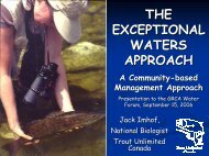
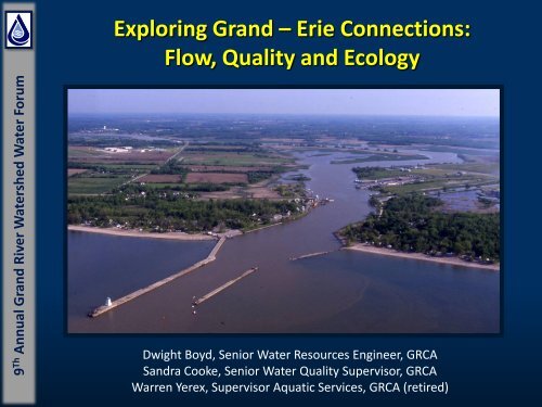
9 Th Annual Grand River Watershed Water Forum<br />
Exploring Grand – Erie Connections:<br />
Flow, Quality and Ecology<br />
<strong>Dwight</strong> <strong>Boyd</strong>, Senior Water Resources Engineer, GRCA<br />
Sandra Cooke, Senior Water Quality Supervisor, GRCA<br />
Warren Yerex, Supervisor Aquatic Services, GRCA (retired)
9 Th Annual Grand River Watershed Water Forum<br />
Tracing the Flow
Grand River In Context to Great Lakes<br />
The Upper Great Lakes Outlet at Lake Huron with a<br />
drainage area of 599,000 km 2<br />
Grand<br />
River<br />
Thames<br />
River<br />
Grand River Watershed<br />
drainage area 6,800 km 2<br />
Maumee<br />
River<br />
Lake Erie<br />
Lake Erie Outlets at Niagara Falls with a<br />
Direct Drainage 84,500 Figure kmfrom 2 Co-ordinated drainage Great Lakes area Physical of 683,000 Data km 1977<br />
2
Grand River In Context to Great Lakes
Lake Erie – Grand River Flows<br />
The Upper Great Lakes Outlet at Lake Huron mean<br />
annual flow 5300 m 3 /s<br />
1930’s drought<br />
1960’s drought<br />
Late 1990’s early 2000’s drought<br />
Grand River Watershed<br />
mean annual flow 80 m 3 /s<br />
Negative local flow can result from evaporation losses of Lake Erie.<br />
Even though Grand River flows make up only a small portion of the local<br />
and over all flow to Lake Erie they are still important.<br />
Mean annual local flow to<br />
Lake Erie 600 m 3 /s<br />
Lake Erie Outlets at Niagara Falls mean<br />
annual flow 5900 m 3 /s
Lake Erie Volume – Grand River Flow Volume
Lake Erie Water Levels
Great Lakes Grand River Land Use<br />
The Grand River watershed is<br />
predominately rural with urban<br />
centres in the central portion.<br />
Note intense agriculture and population in southern Ontario<br />
and the northeastern US impact the quantity and quality of<br />
water delivered to the Great Lakes.
Great Lakes Grand River Population
Grand River Watershed – Linkage to Lake Erie<br />
Understanding or conceptualizing linkages within the<br />
watershed is the starting point to considering linkages to<br />
Lake Erie and the Great Lakes in general.<br />
Functional Units on the Landscape<br />
Functional Linkages to the River<br />
Functional River Reaches<br />
Human Intervention or<br />
influence on functional<br />
processes.<br />
Urbanization, drainage,<br />
dams, nutrient load<br />
River Reaches Connection to Lake Erie
Grand River - Surface Geology<br />
• Underlying physics of the watershed.<br />
• Geological characteristics will influence<br />
what water enters the ground versus what<br />
water runs off.<br />
• There are three distinct areas in the Grand<br />
River watershed.<br />
1. northern till plains<br />
2. central moraines and sand plains<br />
3. southern clay plain<br />
• The Grand River Fisheries Management<br />
Plan uses these functional areas to help<br />
guide fisheries management objectives.<br />
• The geology affects water quality. Finer<br />
materials in the clay and till plains are<br />
easily suspended, they stay in suspended in<br />
the water column. They may also carry<br />
attached nutrient to the river.<br />
• Porous soils in the central moraines require<br />
high nutrient applications to be productive<br />
farm lands. A portion of the applied<br />
nutrients enter the groundwater system<br />
and ultimately the river.
Grand River - Moraines<br />
Moraines are some of the<br />
thickest deposits in the<br />
watershed<br />
• The Orangeville, Paris and<br />
Waterloo Moraines in the<br />
Grand River Watershed<br />
play a very important<br />
hydrologic role.<br />
• These moraines have a<br />
rolling topography with<br />
closed drainage systems.<br />
• The water trapped on the<br />
moraine helps to naturally<br />
moderate floods and<br />
facilitates infiltration to<br />
the ground water system.
Grand River – Moraine Hummocky Topography<br />
Photos from upper Blair – March 2003 G. Rungis<br />
Depression storage example waterloo moraine
Hydrologic Response Units<br />
Surface Geology<br />
Land Cover<br />
Moraine Closed Drainage<br />
(Hummocky Topography)
Grand River – Functional Recharge Areas<br />
• Results from hydrologic modeling<br />
were used to estimate where recharge<br />
is occurring across the watershed.<br />
• These results help define functional<br />
recharge units on the landscape. By<br />
classifying these recharge the<br />
significance of these functional<br />
recharge units can be depicted.<br />
1. 15% of the total area, and<br />
produces 30% of the recharge<br />
2. 30% of the total area, and<br />
produces 60% of the recharge<br />
3. 40% of the total area, and<br />
produces 75% of the recharge<br />
4. Remaining 60% of the total area<br />
produces 25% of the recharge
Grand – Groundwater Linkages<br />
Groundwater is linked back to the river and<br />
the Great Lakes through three main linkages.<br />
These include:<br />
1.Groundwater discharge to water courses and<br />
wetlands.<br />
•Some of the strongest groundwater discharge<br />
occurs<br />
• along the Grand River south of Cambridge<br />
to Brantford<br />
• along the Nith River from New Hamburg to<br />
Paris<br />
• along the lower Whiteman's Creek<br />
•On average as much as 5 to 6 m3/s of groundwater<br />
flows into the river through these reaches providing<br />
important fisheries habitat and assimilative capacity.<br />
2.The other unseen linkage is through the<br />
groundwater system to the Great lakes through the<br />
bedrock or buried bedrock valleys. One example is<br />
the Dundas bedrock valley.<br />
3.Through human use, main example being<br />
municipal water supplies that return water to the<br />
river or Great Lakes through effluent discharges.
Grand River – Runoff Areas<br />
• Results from hydrologic modeling were used<br />
to estimate where runoff is occurring across<br />
the watershed.<br />
• These results help define functional runoff<br />
units on the landscape. By classifying these<br />
runoff units the significance of these<br />
functional units can be depicted.<br />
• High runoff area are associated with high<br />
sediment deliver that has an implications to<br />
water quality. These areas are also have<br />
implications to flooding.<br />
1. 10% of the total area, and produces 25%<br />
of the runoff<br />
2. 30% of the total area, and produces 60%<br />
of the runoff<br />
3. 45% of the total area, and produces 80%<br />
of the runoff<br />
4. Remaining 55% of the total area produces<br />
20% of the runoff
Grand River – Runoff Linkages<br />
• Runoff is delivered back to the river<br />
primarily through streams and wetlands.<br />
• Large portions of the watershed have<br />
been drained. Municipal drains have<br />
been implemented to help move water<br />
off the landscape and to facilitate<br />
agriculture.<br />
• Tile drainage creates a direct link to<br />
watercourses and can have an impact on<br />
water quality and quantity in streams.<br />
• The Rural Water Quality Program and the<br />
Environmental Farm Plan help<br />
landowners with best management<br />
practices to improve and protect water<br />
quality.<br />
• Urban drainage modifies the hydrologic<br />
regime of both surface and groundwater;<br />
including flooding, stream erosion and<br />
water quality components.<br />
• The sub watershed planning and storm<br />
water management programs strive to<br />
comprehensively identify, maintain and<br />
restore key hydrologic functions. The aim<br />
is to maintain or improve water quality<br />
of lands converted to urban land use.
Grand River – Runoff Linkages Flow Regulation<br />
Lake Elevation (m)<br />
1-Jan<br />
16-Jan<br />
31-Jan<br />
15-Feb<br />
2-Mar<br />
17-Mar<br />
1-Apr<br />
16-Apr<br />
1-May<br />
16-May<br />
31-May<br />
15-Jun<br />
30-Jun<br />
15-Jul<br />
30-Jul<br />
14-Aug<br />
29-Aug<br />
13-Sep<br />
28-Sep<br />
13-Oct<br />
28-Oct<br />
12-Nov<br />
27-Nov<br />
12-Dec<br />
27-Dec<br />
Shand Dam Reservoir Elevation Plot 2008<br />
426.0<br />
424.0<br />
422.0<br />
420.0<br />
418.0<br />
416.0<br />
414.0<br />
412.0<br />
410.0<br />
408.0<br />
Date<br />
Shand Upper Buffer Shand Lower Buffer 2008<br />
Of the 28 sewage treatment plants in<br />
the Grand River Watershed 16<br />
discharge to flow regulated reaches.<br />
Three of the four municipal surface<br />
water supplies are located on flow<br />
regulate reaches.<br />
Major reservoirs act to shift the water<br />
budget, spring surpluses are<br />
transferred to summer months.
Grand – Functional River Reaches<br />
Once water is in the river system different types<br />
of river reaches deliver the water to Lake Erie.<br />
River reaches can be crudely categorized into<br />
three types:<br />
1. Estuary reach at the mouth of the river.<br />
2. Backwater reach typically upstream of small<br />
dams<br />
3. Riffle/Recovery reach where pool, run and riffle<br />
sequence are present and repeat themselves.<br />
Natural processes in recovery reaches metabolize<br />
nutrients and help cleanse water and provide<br />
a diverse habitat<br />
Backwater reaches typically are not healthy<br />
reaches, sediment and nutrients accumulate in<br />
these reaches. Natural processes don’t have the<br />
ability to metabolize and cleanse the water.<br />
Note the long backwater reaches in the southern river,<br />
these reaches affect the quality of water reaching Lake<br />
Erie and the dams at the downstream of these reaches<br />
limit fishery migration and habitat diversity.<br />
The ability of recovery reaches to metabolize nutrients<br />
is analogous to the assimilative capacity of these types<br />
of these reaches.
Functional Connection Lake Erie to the Grand River<br />
Port Maitland Lake Erie Elevation (m)<br />
1/30/08 0:00<br />
1/30/08 3:00<br />
1/30/08 6:00<br />
1/30/08 9:00<br />
1/30/08 12:00<br />
1/30/08 15:00<br />
1/30/08 18:00<br />
1/30/08 21:00<br />
1/31/08 0:00<br />
177<br />
Lake Erie at Port Maitland<br />
January 29th 2008 Lake Surge Event<br />
176.5<br />
176<br />
175.5<br />
175<br />
174.5<br />
174<br />
173.5<br />
Date<br />
Port Maitland Elevation (m) Dunnvile Dam Invert 1986 Event Critical Level<br />
• Water at the mouth of the river is constantly fluctuating and exchanging with the Lake Erie.<br />
• Occasionally these normal fluctuation and oscillations are disturbed by lake surges setup by<br />
wind blowing down Lake Erie or across the lake.<br />
• This surges can development in a matter of hours and push water back up the river flooding<br />
wetlands and marshes and building located in the floodplain.<br />
• Lake surges are part of a natural process and are important to the ecosystem<br />
• Occasionally the lake surge is higher than the crest of Dunnville Dam.
Summary<br />
1. Water flows down hill and what enters the river ends up in<br />
Lake Erie<br />
2. Managing lake issues takes a collective effort of various<br />
technical disciplines, agencies, NGO’s and land owners<br />
3. Dealing with water quality and quantity issues at their<br />
source before water enters the Great Lake is fundamental<br />
4. We need to better technical understand the functional<br />
river reaches<br />
5. Removing river barriers needs to be considered<br />
6. Long term monitoring and research is the foundation to<br />
understanding processes and issues
Credits and Data Sources<br />
• Flow Data from Water Survey of Canada<br />
• Great Lakes co-ordinated data of drainage areas, flows and volumes Chuck<br />
Southam Boundary Waters Issues Unit Environment Canada<br />
• Watershed boundaries Mike Shantz Boundary Waters Issues Unit Environmental<br />
Canada<br />
• Atlas Maps of the Great Lakes, Environment Canada and US Environmental<br />
Protection Agency<br />
• Geology and moraine information, funding bedrock valley exploration, Cam<br />
Baker, Andy Bajr, Ontario Geological Survey<br />
• Andrew Piggott Great Lakes recharge and groundwater information, Canadian<br />
Centre for Inland Waters<br />
• Update recharge-runoff maps S. Shifflett, GRCA<br />
• T. Ryan, Rural Water Quality Program<br />
• G. Rungis Subwatershed Planning and Stormwater Management Programs<br />
• Maps Jeff Pitcher, GRCA