Delaware Water Gap National Recreation Area ... - Explore Nature
Delaware Water Gap National Recreation Area ... - Explore Nature
Delaware Water Gap National Recreation Area ... - Explore Nature

You also want an ePaper? Increase the reach of your titles
YUMPU automatically turns print PDFs into web optimized ePapers that Google loves.
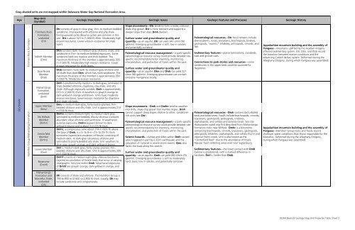
Gray-shaded units are not mapped within <strong>Delaware</strong> <strong>Water</strong> <strong>Gap</strong> <strong>National</strong> <strong>Recreation</strong> <strong>Area</strong>.<br />
Age<br />
Map Unit<br />
(Symbol)<br />
Geologic Description Geologic Issues Geologic Features and Processes Geologic History<br />
DEVONIAN<br />
Trimmers Rock Formation<br />
Hamilton Group-Mahantango Formation<br />
Trimmers Rock<br />
Formation,<br />
undivided<br />
(Dtr)<br />
Millrift Member<br />
(Dtm)<br />
Sloat Brook<br />
Member<br />
(Dtsb)<br />
Mahantango<br />
Formation,<br />
undivided<br />
(Dmh)<br />
Upper Member<br />
(Dmu)<br />
Nis Hollow<br />
Member<br />
(Dmhn)<br />
Centerfield<br />
Member<br />
(Dmhc)<br />
Lower Member<br />
(Dml)<br />
Biostrome<br />
(Dmhf)<br />
Mahantango<br />
Formation and<br />
Marcellus Shale,<br />
undivided<br />
(Dh)<br />
Dtr consists of gray to olive-gray, thin- to medium-bedded<br />
sandstone, interlayered with siltstone and silty shale.<br />
Fining-upward cycles (Bouma cycles) are common in this<br />
unit. Dtr is about 323 m (1,060 ft) thick. Moderately high<br />
erosion resistance. Lower erosion resistance for shale<br />
layers.<br />
Dtm contains dark- to medium-gray siltstone, shale, and<br />
sandstone in thin- to medium-bedded exposures. Some<br />
sandstone beds are massive and thick bedded. The<br />
maximum thickness of this member is approximately 305<br />
m (1,000 ft). Moderately high erosion resistance. Lower<br />
erosion resistance for shale layers.<br />
Dtsb contains more dark- to medium-gray siltstone and<br />
silt shale than does Dtm, which has more sandstone. The<br />
maximum thickness of this member is approximately 290<br />
m (950 ft). Moderate erosion resistance.<br />
Dmh is predominantly medium- to dark-gray, laminated to<br />
finely bedded siltstone, claystone, clay shale, and silty<br />
shale. Although regionally variable, Dmh is approximately<br />
610 m (2,000 ft) thick. It weathers to grayish orange to<br />
dark yellowish orange and brown. Units have moderate<br />
erosion resistance; lower erosion resistance for claystone<br />
and shale-rich beds.<br />
Dmu is medium-dark-gray, fairly coarse-grained, thinbedded<br />
siltstone and silty shale. Unit is approximately 213<br />
m (700 ft) thick.<br />
Dmhn contains medium-light- to medium-dark-gray,<br />
laminated to medium-bedded, blocky siliceous (contains<br />
abundant silica) siltstone and sandstone. In weathered<br />
outcrop exposures, Dmhn appears brown to dark<br />
yellowish brown and is about 5 m (15 ft) thick.<br />
Dmhc, a conspicuous zone about 274 m (900 ft) above<br />
the base of Dmh, is a 5- to 8-m- (15- to 25-ft-) thick<br />
biostrome (layered accumulation of fossils) consisting of<br />
medium-dark- to dark-gray calcareous siltstone and<br />
laminated to poorly bedded silty shale. Unit weathers to<br />
olive gray, grayish orange, and dark yellowish brown.<br />
Dml is medium-dark-gray, fairly coarse-grained, thinbedded<br />
siltstone and silty shale. Unit is approximately 335<br />
m (1,100 ft) thick.<br />
Dmhf consists of medium-light-gray siltstone biostrome<br />
(layered accumulation of fossils) beds that occur at varying<br />
stratigraphic horizons within Dmh. Weathered exposures<br />
of Dmhf are grayish orange, dark yellowish orange, and<br />
brown.<br />
Dh consists of shale and siltstone. The Hamilton Group is<br />
790 to 850 m (2,600 to 2,800 ft) thick. Locally, Dh may<br />
include sandstone and conglomerate.<br />
Slope movements—Dtr tends to form a loose, colluvial<br />
shale-chip gravel. Dtr is more resistant and supports a<br />
steeper slope than does Dmh (below).<br />
Surface water and groundwater quality and<br />
quantity—as an aquifer, Dtr can yield 341 L/min (90<br />
gal/min). Emerging groundwater is soft, low in solutes,<br />
and potentially corrosive.<br />
Paleontological resource management—a park-specific<br />
paleontological resource survey could provide detailed sitespecific<br />
recommendations for inventory, monitoring,<br />
interpretation, and protection of fossils within the park.<br />
Surface water and groundwater quality and<br />
quantity—as an aquifer, Dtm and Dtsb can yield 227<br />
L/min (60 gal/min). Emerging groundwater can contain<br />
excessive manganese locally.<br />
Slope movements—Dmh and Dmhn tend to weather<br />
into thick, shale-chip gravel that mantles slopes. Dmh<br />
cannot support steep slopes relative to other, sandstonerich<br />
units (see Dtr).<br />
Paleontological resource management—a park-specific<br />
paleontological resource survey could provide detailed sitespecific<br />
recommendations for inventory, monitoring,<br />
interpretation, and protection of fossils within the park.<br />
Seismic hazards—slumps and slides within Dmh caused<br />
were triggered in part by a 2011 earthquake and the<br />
saturation of material in severe storm events. Qoic also<br />
flanks the road along this stretch.<br />
Surface water and groundwater quality and<br />
quantity—as an aquifer, Dmh can yield 265 L/min (70<br />
gal/min). Emerging groundwater is soft to moderately<br />
hard, basic, low in solutes, and potentially corrosive.<br />
Paleontological resources—Dtr fossil remains include<br />
diverse plants, corals, bryozoans, brachiopods, bivalves,<br />
gastropods, “worms,” trilobites, arthropods, crinoids, and<br />
fish.<br />
Sedimentary features—planar laminations, crossbeds,<br />
load and groove casts.<br />
Connections to park stories and resources—some<br />
sandstones in the upper beds could be quarried for<br />
flagstones.<br />
Paleontological resources—Dmh contains bioturbated<br />
beds and biostromes. Fossils include brachiopods, crinoids,<br />
bryozoans, gastropods, pelecypods, trilobites,<br />
cephalopods, and solitary and colonial corals. Sea star<br />
Hudsonaster wardi was first described from Mahantango<br />
Formation rocks near Milford. Dmhc is a biostrome<br />
containing brachiopods, crinoids, bryozoans, gastropods,<br />
pelecypods, trilobites, cephalopods, and solitary (horn) and<br />
colonial (horn) corals. Unit is also known as the<br />
“Centerfield Reef” due to the abundance of fossils.<br />
Popular fossil collecting areas exist near Saylorsburg.<br />
Sedimentary features—the lower contact with Dmb<br />
(below) is gradational, with a marked difference in<br />
hardness. Dml is harder than Dmb.<br />
Appalachian mountain building and the assembly of<br />
Pangaea—mountains uplifted by the Acadian orogeny<br />
affected sedimentary system. Dtr, Dtm, and Dtsb record<br />
the transition between marine conditions and the<br />
advancing Catskill deltaic system. Deformed during the<br />
Alleghany Orogeny, during which Pangaea was assembled.<br />
Appalachian mountain building and the assembly of<br />
Pangaea—Hamilton Group rocks and fossils record<br />
shallower water conditions than those responsible for the<br />
Marcellus. Deformed during the Alleghany Orogeny,<br />
during which Pangaea was assembled.<br />
DEWA Bedrock Geologic Map Unit Properties Table, Sheet 2