Delaware Water Gap National Recreation Area ... - Explore Nature
Delaware Water Gap National Recreation Area ... - Explore Nature
Delaware Water Gap National Recreation Area ... - Explore Nature

Create successful ePaper yourself
Turn your PDF publications into a flip-book with our unique Google optimized e-Paper software.
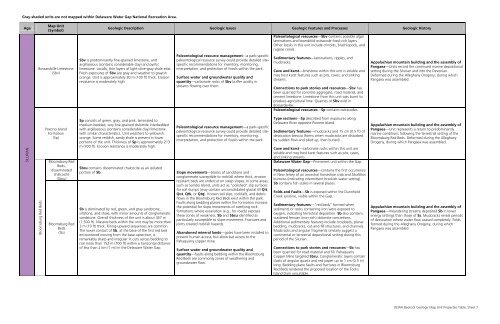
Gray-shaded units are not mapped within <strong>Delaware</strong> <strong>Water</strong> <strong>Gap</strong> <strong>National</strong> <strong>Recreation</strong> <strong>Area</strong>.<br />
Age<br />
Map Unit<br />
(Symbol)<br />
Bossardville Limestone<br />
(Sbv)<br />
Geologic Description Geologic Issues Geologic Features and Processes Geologic History<br />
Sbv is predominantly fine-grained limestone, and<br />
argillaceous (contains considerable clay) and pyritic<br />
limestone. Locally, thin layers of light-olive-gray shale exist.<br />
Fresh exposures of Sbv are gray and weather to grayish<br />
orange. Unit is approximately 30 m (100 ft) thick. Erosion<br />
resistance is moderately high.<br />
Paleontological resource management—a park-specific<br />
paleontological resource survey could provide detailed sitespecific<br />
recommendations for inventory, monitoring,<br />
interpretation, and protection of fossils within the park.<br />
Surface water and groundwater quality and<br />
quantity—carbonate rocks of Sbv buffer acidity in<br />
streams flowing over them.<br />
Paleontological resources—Sbv contains possible algal<br />
laminations and leoerditiid ostracode fossil-rich layers.<br />
Other fossils in this unit include crinoids, brachiopods, and<br />
rugose corals.<br />
Sedimentary features—laminations, ripples, and<br />
mudcracks.<br />
Cave and karst—limestone within this unit is soluble and<br />
may host karst features such as pits, caves, and sinking<br />
streams.<br />
Connections to park stories and resources—Sbv has<br />
been quarried for concrete aggregate, road material, and<br />
cement limestone. Limestone from this unit was burnt to<br />
produce agricultural lime. Quarries of Sbv exist in<br />
Bossardsville.<br />
Paleontological resources—Sp contains ostracodes.<br />
Appalachian mountain building and the assembly of<br />
Pangaea—Units record the continued marine depositional<br />
setting during the Silurian and into the Devonian.<br />
Deformed during the Alleghany Orogeny, during which<br />
Pangaea was assembled.<br />
SILURIAN<br />
Bloomsburg Red Beds<br />
Poxono Island<br />
Formation<br />
(Sp)<br />
Bloomsburg Red<br />
Beds,<br />
disseminated<br />
chalcocite<br />
(Sbcu)<br />
Bloomsburg Red<br />
Beds<br />
(Sb)<br />
Sp consists of green, gray, and pink, laminated to<br />
medium-bedded, very fine-grained dolomite interbedded<br />
with argillaceous (contains considerable clay) limestone<br />
with similar characteristics. Unit weathers to yellowish<br />
orange. Some reddish, sandy shale is present in lower<br />
portions of the unit. Thickness of Sp is approximately 213<br />
m (700 ft). Erosion resistance is moderately high.<br />
Sbcu contains disseminated chalcocite as an isolated<br />
portion of Sb.<br />
Sb is dominated by red, green, and gray sandstone,<br />
siltstone, and shale, with minor amounts of conglomeratic<br />
sandstone. Overall thickness of the unit is about 457 m<br />
(1,500 ft). Massive beds within the unit may be more than<br />
3 m (10 ft) thick. Fining-upward sequences are common.<br />
The lower contact of Sb, at the base of the first red bed<br />
encountered moving from the base upsection, is<br />
remarkably sharp and irregular. It cuts across bedding to<br />
rise more than 152 m (700 ft) within a horizontal distance<br />
of less than 2 km (1 mi) in the <strong>Delaware</strong> <strong>Water</strong> <strong>Gap</strong>.<br />
Paleontological resource management—a park-specific<br />
paleontological resource survey could provide detailed sitespecific<br />
recommendations for inventory, monitoring,<br />
interpretation, and protection of fossils within the park.<br />
Slope movements—blocks of sandstone and<br />
conglomerate susceptible to rockfall where thick, erosion<br />
resistant beds are undercut on steep slopes. In some areas,<br />
such as Sambo Island, units act as “polished” slip surfaces<br />
for soil slumps (may contain unconsolidated glacial till Qit,<br />
Qot, Qtk, or Qtq). Known soil slips, rockfalls, and debris<br />
flows in the Bloomsburg Red Beds exist within the park.<br />
Faults along bedding planes within the formation increase<br />
the potential for slope movements of overlying rock<br />
formations where excavation (e.g., for roads) exposes<br />
these zones of weakness. Sb and Sbcu identified as<br />
particularly susceptible to slope movement. Fractures and<br />
joints created rockfall hazards.<br />
Abandoned mineral lands—gates have been installed to<br />
prevent human access, but allow bat access to the<br />
Pahaquarry copper mine.<br />
Surface water and groundwater quality and<br />
quantity—faults along bedding within the Bloomsburg<br />
Red Beds are commonly zones of weathering and<br />
groundwater flow.<br />
Type sections—Sp described from exposures along<br />
<strong>Delaware</strong> River opposite Poxono Island.<br />
Sedimentary features—mudcracks and 15 cm (0.5 ft) of<br />
dessication breccia (forms when mudcracks are disturbed<br />
by sudden flow and piled up, then buried).<br />
Cave and karst—carbonate rocks within this unit are<br />
soluble and may host karst features such as pits, caves,<br />
and sinking streams.<br />
<strong>Delaware</strong> <strong>Water</strong> <strong>Gap</strong>—Prominent unit within the <strong>Gap</strong>.<br />
Paleontological resources—contains the first occurrence<br />
in New Jersey of an ancestral horseshoe crab and Skolithos<br />
burrows (indicating intermittent brackish-water setting).<br />
Sb contains fish scales in several places.<br />
Folds and Faults—Sb is exposed within the Dunnfield<br />
Creek syncline, visible within the <strong>Gap</strong>.<br />
Sedimentary features—“red beds” formed when<br />
sediments or rocks containing iron were exposed to<br />
oxygen, indicating terrestrial deposition. Sb also contains<br />
scattered ferroan (iron-rich) dolomite concretions.<br />
Additional sedimentary features include crossbeds, planar<br />
bedding, mudcracks, cut-and-fill structures, and channels.<br />
Mudcracks and angular fragments similarly suggest a<br />
continental or terrestrial depositional setting during this<br />
period of the Silurian.<br />
Connections to park stories and resources—Sb has<br />
been quarried for road material and fill. Pahaquarry<br />
Copper Mine targeted Sbcu. Conglomeratic layers contain<br />
clasts of angular quartz and red jasper up to 1 cm (0.5 in)<br />
long. Bedding plane faults and fractures in Bloomsburg<br />
Red Beds rendered the proposed location of the Tocks<br />
Island Dam unsuitable.<br />
Appalachian mountain building and the assembly of<br />
Pangaea—Unit represents a return to predominantly<br />
marine conditions following the terrestrial setting of the<br />
Bloomsburg Red Beds. Deformed during the Alleghany<br />
Orogeny, during which Pangaea was assembled.<br />
Appalachian mountain building and the assembly of<br />
Pangaea—meandering streams deposited Sb in lower<br />
energy settings than those of Ss. Mudcracks reveal periods<br />
of dessication where water flow ceased completely. Folds<br />
formed during the Alleghany Orogeny, during which<br />
Pangaea was assembled.<br />
DEWA Bedrock Geologic Map Unit Properties Table, Sheet 7