SS ETAL MANOR - INFOMAR
SS ETAL MANOR - INFOMAR
SS ETAL MANOR - INFOMAR

Create successful ePaper yourself
Turn your PDF publications into a flip-book with our unique Google optimized e-Paper software.
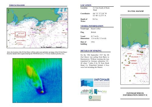
WRECK IMAGERY<br />
LOCATION<br />
Location 13.5 km South of Hook<br />
Head<br />
Coordinates -06° 53’ 57.518” W<br />
52° 00’ 12.273” N<br />
Depth of 54.5 m<br />
Water<br />
VE<strong>SS</strong>EL INFORMATION<br />
Vessel type Steam Collier<br />
Flag British<br />
Vessel 81.7 m (l),<br />
Dimensions 11.6 m (b), 5.5 m (d)<br />
Date of 1916<br />
building<br />
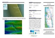
<strong>SS</strong> <strong>ETAL</strong> <strong>MANOR</strong><br />
Above the location of the <strong>SS</strong> Etal Manor off the south coast and below an image of the <strong>SS</strong> Etal Manor<br />
from the shaded relief acquired during the <strong>INFOMAR</strong> survey CV10_02, Southern priority area.<br />
DETAILS OF SINKING<br />
On the 19th September 1917 the <strong>SS</strong><br />
Etal Manor was sailing from Barry to<br />
Queenstown. Without warning she was<br />
torpedoed by German submarine UC-<br />
48 when 7 miles S by W from Hook<br />
Head, Co. Waterford, Ireland. 6 lives<br />
were lost including the Master.<br />
<strong>INFOMAR</strong> WRECK<br />
INFORMATION SHEET 15
VE<strong>SS</strong>EL HISTORY<br />
The <strong>SS</strong> Etal Manor was built in 1916 by J.<br />
Crown & Sons Ltd., Sunderland. At the time<br />
of her loss the <strong>SS</strong> Etal Manor was owned by J<br />
Fenwick & sons, London. The <strong>SS</strong> Etal Manor<br />
had two boilers and a triple expansion engine.<br />
DIVE INFORMATION<br />
Wrecks over 100 years old and archaeological<br />
objects found underwater are protected under<br />
the National Monuments (Amendment) Acts<br />
1987 and 1994. As the <strong>SS</strong> Etal Manor is over<br />
100 years old, it is protected and a license is<br />
required to dive the site which can be obtained<br />
from:<br />
www.archaeology.ie/servlet/apply_licence.jsp<br />
Under the legislation all diving on protected<br />
wreck sites or with the intention of searching<br />
for archaeological underwater material is<br />
subject to such licensing requirements.<br />
ABOUT <strong>INFOMAR</strong><br />
Covering some 125,000 square<br />
kilometres of underwater territory,<br />
<strong>INFOMAR</strong> (the INtegrated Mapping<br />
FOr the Sustainable Development of<br />
Ireland’s MARine Resource) project<br />
will produce integrated mapping<br />
products covering the physical,<br />
chemical and biological features of the<br />
seabed. <strong>INFOMAR</strong> will initially focus<br />
on 26 priority bays and three priority<br />
areas around the coast delivering:<br />
hydrographic maps, illustrating<br />
everything from sandbars to underwater<br />
canyons and cliffs; seabed classification<br />
maps showing the type of sediment on<br />
the seabed. <strong>INFOMAR</strong> provides key<br />
baseline data to support coastal and<br />
inshore development. Making this<br />
information available to the world aims<br />
to stimulate research and development<br />
of Ireland’s 220 million acres under the<br />
sea. The data will be of interest to<br />
fisheries managers, aquaculture<br />
operators, coastal zone managers and<br />
engineers, offshore engineering<br />
interests, licensing authorities and those<br />
carrying out environmental impact<br />
assessments. Indeed this unique dataset<br />
is of interest in its own right because of<br />
the sheer volume of data collected<br />
FURTHER READING/REFERENCES<br />
www.infomar.ie<br />
www.irishwrecksonline.net<br />
http://www.archaeology.ie/en/Shipwreck<br />
Database/<br />
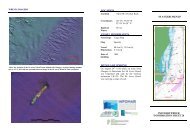
WRECK IMAGERY<br />
Above a 3D image of the <strong>SS</strong> Etal Manor using Caris Hips & Sips Hydrographic software and<br />
below a postcard of the