
You also want an ePaper? Increase the reach of your titles
YUMPU automatically turns print PDFs into web optimized ePapers that Google loves.
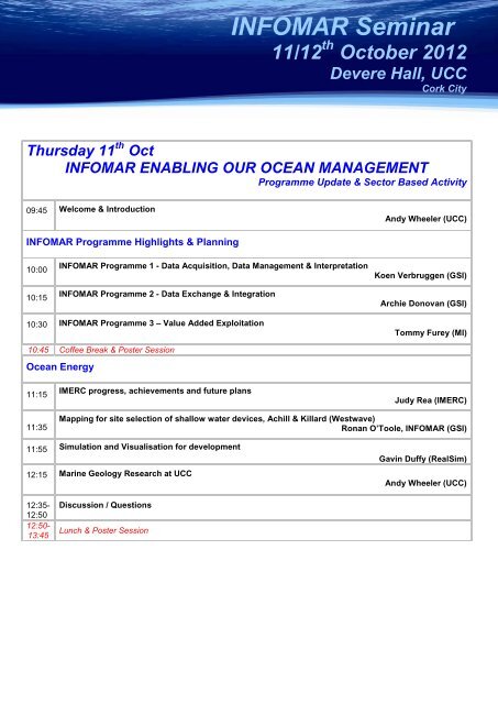
<strong>INFOMAR</strong> <strong>Seminar</strong><br />
11/12 th October 2012<br />
Devere Hall, UCC<br />
Cork City<br />
Thursday 11 th Oct<br />
<strong>INFOMAR</strong> ENABLING OUR OCEAN MANAGEMENT<br />
Programme Update & Sector Based Activity<br />
09:45 Welcome & Introduction<br />
Andy Wheeler (UCC)<br />
<strong>INFOMAR</strong> Programme Highlights & Planning<br />
10:00<br />
10:15<br />
<strong>INFOMAR</strong> Programme 1 - Data Acquisition, Data Management & Interpretation<br />
<strong>INFOMAR</strong> Programme 2 - Data Exchange & Integration<br />
Koen Verbruggen (GSI)<br />
Archie Donovan (GSI)<br />
10:30 <strong>INFOMAR</strong> Programme 3 – Value Added Exploitation<br />
Tommy Furey (MI)<br />
10:45 Coffee Break & Poster Session<br />
Ocean Energy<br />
11:15<br />
IMERC progress, achievements and future plans<br />
Judy Rea (IMERC)<br />
11:35<br />
Mapping for site selection of shallow water devices, Achill & Killard (Westwave)<br />
Ronan O’Toole, <strong>INFOMAR</strong> (GSI)<br />
11:55 Simulation and Visualisation for development<br />
12:15 Marine Geology Research at UCC<br />
Gavin Duffy (RealSim)<br />
Andy Wheeler (UCC)<br />
12:35-<br />
12:50<br />
12:50-<br />
13:45<br />
Discussion / Questions<br />
Lunch & Poster Session
<strong>INFOMAR</strong> <strong>Seminar</strong><br />
Thur 11 th October 2012<br />
UCC<br />
Cork<br />
Environmental & Habitat Mapping<br />
14.00<br />
Policy – New marine opportunities at the national and European levels: Harnessing Our Ocean Wealth<br />
and the EU Green Paper “from seabed mapping to ocean forecasting”<br />
Peter Heffernan, CEO Marine Institute<br />
14:20<br />
14.40<br />
15:00<br />
Marine Strategy Framework Directive Update<br />
UK Marine Conservation Zone<br />
<strong>INFOMAR</strong> Data - The International Context<br />
Pat Duggan (DCELG)<br />
Alex Callaway (CEFAS)<br />
Janine Guinan, <strong>INFOMAR</strong> (GSI)<br />
15:20 Coffee<br />
Aquaculture & Fisheries<br />
15:45<br />
16:05<br />
The deepsea project, offshore organic salmon farming<br />
Baseline mapping for modelling and site selection<br />
Ben Dallaghan (BIM)<br />
David Hardy, <strong>INFOMAR</strong> (GSI)<br />
16:25<br />
Seabed mapping in Norway – delivering information for coastal and ocean management<br />
Margaret Dolan (NGU)<br />
16:45<br />
Use of biological data to groundtruth <strong>INFOMAR</strong> seabed classification<br />
David O’Sullivan (MI)<br />
17:00<br />
17:15-<br />
17:30<br />
Seabed data interfacing with fisheries navigation technology<br />
John O’Mahony (Belco Marine Electronics)<br />
Presentation on Cosantóir Bradán, from Fisheries patrol to <strong>INFOMAR</strong> Survey<br />
Archie Donovan, <strong>INFOMAR</strong> (GSI)<br />
RESON SPONSORED RECEPTION<br />
Custom House, Cork City
<strong>INFOMAR</strong> <strong>Seminar</strong><br />
Fri 12 th October 2012<br />
UCC<br />
Cork<br />
Friday 12 th October<br />
<strong>INFOMAR</strong> ENABLING OUR OCEAN MANAGEMENT<br />
Operations, Heritage & Research<br />
Hydrography & Operations<br />
09:00<br />
Categorising our coastal waters, and progress on INIS Hydro, INTERREG IVA<br />
Sean Cullen, <strong>INFOMAR</strong> (GSI)<br />
09:20<br />
09:40<br />
<strong>INFOMAR</strong> - Mapping Irelands busiest waters<br />
Satellite bathymetry contributes to the coastal mapping challenge<br />
Kevin Sheehan, <strong>INFOMAR</strong> (MI)<br />
Helen Needham (Proteus)<br />
10:00<br />
Results and field trials of an automated vessel-waypoint planner for high resolution multibeam<br />
sonar surveys<br />
James Riordan (SonarSim)<br />
10:30 Morning Coffee / Networking Break & Poster Session<br />
Mapping our Heritage<br />
11:00<br />
11:20<br />
Visualising Shipwrecks in 3D<br />
Atlanterra, a 3D sea to shore view of our heritage<br />
Charise McKeon, <strong>INFOMAR</strong> (GSI)<br />
Eddie McMonagle (GSI)<br />
11:35<br />
Mapping Irelands Coastal Heritage and an Overview of the MSFD Marine Atlas<br />
Ali Robinson (Compass Informatics)<br />
11:55<br />
UC-42, remote discovery and investigations<br />
Eoghan Kieran (Moore Marine)<br />
<strong>INFOMAR</strong> – Applied Research<br />
12:15<br />
12:35<br />
<strong>INFOMAR</strong> – Applied Research Collaborations<br />
Research & Future Plans<br />
Xavier Monteys, <strong>INFOMAR</strong> (GSI)<br />
Koen Verbruggen (GSI)