

Report PDF (3.7 MB) - USGS
Report PDF (3.7 MB) - USGS
Report PDF (3.7 MB) - USGS

Create successful ePaper yourself
Turn your PDF publications into a flip-book with our unique Google optimized e-Paper software.
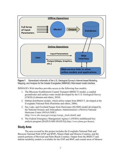
Figure 1. Generalized schematic of the U.S. Geological Survey's Internet-based Modeling,<br />
Mapping, and Analysis for the Greater Everglades (IMMAGE) Web-based model interface.<br />
IMMAGE's Web interface provides access to the following four models:<br />
1. The BIscayne SouthEastern Coastal Transport (BISECT) model, a coupled<br />
groundwater and surface-water model developed by the U.S. Geological Survey<br />
(<strong>USGS</strong>) (Lohmann and others, 2010).<br />
2. Habitat distribution models, which utilize output from BISECT, developed at the<br />
Everglades National Park (Pearlstine and others, 2006).<br />
3. Sea, Lake, and Overland Surges from Hurricanes (SLOSH) model developed by<br />
the National Oceanic and Atmospheric Administration’s (NOAA) National<br />
Hurricane Center (NOAA/NHC)<br />
(http://www.nhc.noaa.gov/ssurge/ssurge_slosh.shtml), and<br />
4. The Federal Emergency Management Agency’s (FEMA) multihazard loss<br />
analysis program [HAZUS-MH (HAZUS)] (http://www.fema.gov/hazus).<br />
Study Area<br />
The area covered by this project includes the Everglades National Park and<br />
Biscayne National Park (ENP and BNP), Miami-Dade and Monroe Counties, and the<br />
eastern portions of Broward and Palm Beach Counties. Output from the BISECT and<br />
habitat suitability models is available for the ENP and BNP, and coastal areas of Monroe<br />
3


