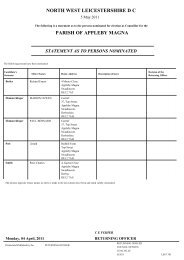
Appleby Magna, Measham and Oakthorpe Proformas and Map
Appleby Magna, Measham and Oakthorpe Proformas and Map
Appleby Magna, Measham and Oakthorpe Proformas and Map

You also want an ePaper? Increase the reach of your titles
YUMPU automatically turns print PDFs into web optimized ePapers that Google loves.
Parish<br />
As Ref<br />
Related/Previous Site<br />
References<br />
Site Description<br />
Strategic Housing L<strong>and</strong> Availability Assessment Proforma<br />
<strong>Appleby</strong><br />
Ap1<br />
PKA H36<br />
West of <strong>Measham</strong> Road, <strong>Appleby</strong><br />
<strong>Magna</strong>. Greenfield site adjacent to<br />
urban area.<br />
Grid<br />
Reference<br />
Site size<br />
X<br />
Y<br />
4.52 Ha<br />
Current Use Agriculture Adjacent Uses Resi / agriculture<br />
L<strong>and</strong> Type<br />
Greenfield<br />
Site Location<br />
<strong>Appleby</strong> <strong>Magna</strong><br />
Character of<br />
surroundings<br />
Edge of village. Mainly rural.<br />
Distance to Bus Stop<br />
from centre of site<br />
Distance to Primary<br />
School from centre of site<br />
Distance to Local Centre<br />
from centre of site<br />
Distance to Post Office<br />
from centre of site<br />
Distance to Health Centre<br />
from centre of site<br />
Distance to Secondary<br />
School from centre of site<br />
Distance to open space<br />
from centre of site<br />
Additional Accessibility<br />
information<br />
2970<br />
1140<br />
2540<br />
430<br />
2400<br />
9120<br />
640<br />
Accessibility<br />
Distance to Bus Stop from<br />
site access<br />
Distance to Primary School<br />
from site access<br />
Distance to Local Centre<br />
from site access<br />
Distance to Post Office<br />
from site access<br />
Distance to Health Centre<br />
from site access<br />
Distance to Secondary<br />
School from site access<br />
Distance to open space<br />
from site access<br />
Constraints<br />
Identified Red constraint Agricultural L<strong>and</strong> Grade 2<br />
Mitigatable<br />
Comments<br />
Contaminated L<strong>and</strong> No known issues<br />
Environmental<br />
Eastern extent falls within Highways Consultancy Zone<br />
70m from Conservation Area<br />
Agricultural L<strong>and</strong> Grade 2<br />
The site drains into the River Mease SAC<br />
Topographical<br />
20m from Aquifer Water Boundary -- “consult South Staffordshire Waterworks<br />
Company on unsewered development <strong>and</strong> l<strong>and</strong>fill / excavation”<br />
Planning Policy<br />
Agricultural L<strong>and</strong> classification<br />
Accessibility<br />
No known issues<br />
Ownership<br />
No known issues<br />
Can the constraints be<br />
mitigated<br />
Possible mitigation<br />
measures<br />
Market Interest<br />
Timeframe for development<br />
2910<br />
1160<br />
2480<br />
380<br />
2420<br />
9000<br />
Yes. Regarding the River Mease SAC a number of solutions are being examined<br />
<strong>and</strong> active discussions are taking place between the LPA, NE, EA <strong>and</strong> STW.<br />
Whilst a ‘solution’ has not yet been found there are realistic prospects of a solution<br />
given the active involvement of the statutory bodies.<br />
630<br />
Availability/ Achievability<br />
Non site specific although the rural areas of the District are in a strong<br />
housing market.<br />
2 nd 5 years
Estimated number of dwellings 135<br />
Estimated Density<br />
30 Dwellings per hectare<br />
Estimated Build Rate<br />
40 dwellings per annum<br />
Suitable<br />
Agricultural l<strong>and</strong> is a significant constraint but as is the case in Ashby, it<br />
would be unreasonable to exclude sites from consideration at this<br />
stage given the substantial amount of high quality agricultural l<strong>and</strong> in<br />
the District.<br />
Available<br />
Yes<br />
Achievable<br />
Yes<br />
Excluded from consideration<br />
To exclude the site is its entirety would be to give a zero allocation to<br />
<strong>Appleby</strong> <strong>Magna</strong> as all l<strong>and</strong> around the village is Grade 2 Agricultural<br />
L<strong>and</strong>.<br />
Comment<br />
Overall assessment<br />
Include<br />
Additional information
Parish<br />
As Ref<br />
Related/Previous Site<br />
References<br />
Site Description<br />
Strategic Housing L<strong>and</strong> Availability Assessment Proforma<br />
<strong>Appleby</strong><br />
Ap2<br />
PKA H49<br />
<strong>Measham</strong> Road, <strong>Appleby</strong> <strong>Magna</strong>.<br />
Greenfield site adjacent to existing<br />
urban area.<br />
Grid<br />
Reference<br />
Site size<br />
X<br />
Y<br />
0.41 Ha<br />
Current Use Agriculture / Scrubl<strong>and</strong> Adjacent Uses Resi<br />
L<strong>and</strong> Type<br />
Greenfield<br />
Site Location<br />
<strong>Appleby</strong> <strong>Magna</strong><br />
Character of<br />
surroundings<br />
Edge of village. Mainly rural.<br />
Distance to Bus Stop<br />
from centre of site<br />
Distance to Primary<br />
School from centre of site<br />
Distance to Local Centre<br />
from centre of site<br />
Distance to Post Office<br />
from centre of site<br />
Distance to Health Centre<br />
from centre of site<br />
Distance to Secondary<br />
School from centre of site<br />
Distance to open space<br />
from centre of site<br />
Additional Accessibility<br />
information<br />
3030<br />
1030<br />
2560<br />
290<br />
2460<br />
8170<br />
550<br />
Accessibility<br />
Distance to Bus Stop from<br />
site access<br />
Distance to Primary School<br />
from site access<br />
Distance to Local Centre<br />
from site access<br />
Distance to Post Office<br />
from site access<br />
Distance to Health Centre<br />
from site access<br />
Distance to Secondary<br />
School from site access<br />
Distance to open space<br />
from site access<br />
3040<br />
1020<br />
2580<br />
300<br />
2470<br />
8170<br />
Constraints<br />
Identified Red constraint Agricultural L<strong>and</strong> Grade 2<br />
Mitigatable<br />
Comments<br />
Contaminated L<strong>and</strong> No known issues<br />
Environmental Agricultural L<strong>and</strong> Grade 2<br />
Western extent of site falls within Highways Consultancy Zone<br />
Abuts Conservation Area<br />
300m from Archaeology Site / Ancient Monument<br />
Site drains into the River Mease SAC<br />
Topographical 50 west of FZ 2 & 3<br />
Planning Policy<br />
Previous rejection S78 appeal.<br />
Accessibility<br />
No known issues<br />
Ownership<br />
No known issues<br />
Can the constraints be<br />
mitigated<br />
Yes. Regarding the River Mease SAC a number of solutions are being examined<br />
<strong>and</strong> active discussions are taking place between the LPA, NE, EA <strong>and</strong> STW.<br />
Whilst a ‘solution’ has not yet been found there are realistic prospects of a solution<br />
Possible mitigation<br />
measures<br />
Market Interest<br />
540<br />
given the active involvement of the statutory bodies.<br />
Better quality submission would help taking into account character <strong>and</strong><br />
appearance of this part of the village given the S78 appeal.<br />
Availability/ Achievability<br />
Non site specific although the rural areas of the District are in a strong<br />
housing market.
Timeframe for development<br />
2 nd 5 years<br />
Estimated number of dwellings 12<br />
Estimated Density<br />
30 dwellings per hectare<br />
Estimated Build Rate<br />
One year<br />
Suitable<br />
Yes<br />
Available<br />
Yes<br />
Achievable<br />
Yes<br />
Excluded from consideration<br />
Comment<br />
Agricultural l<strong>and</strong> is an issue but this site is within limits to development<br />
<strong>and</strong> main constraints relate to difficulty of accommodating development<br />
that does not erode the character <strong>and</strong> appearance of the village. The<br />
appeal dismissal is not a reason to exclude the site from the SHLAA.<br />
Overall assessment<br />
Include<br />
Additional information
Parish<br />
As Ref<br />
Related/Previous Site<br />
References<br />
Site Description<br />
Strategic Housing L<strong>and</strong> Availability Assessment Proforma<br />
<strong>Appleby</strong><br />
Ap3<br />
PKA H37<br />
West of Church Street, <strong>Appleby</strong><br />
<strong>Magna</strong>. Greenfield site adjacent to<br />
existing built up area.<br />
Grid<br />
Reference<br />
Site size<br />
X<br />
Y<br />
4.20 Ha<br />
Current Use Agriculture Adjacent Uses Agriculture (W) / Resi<br />
L<strong>and</strong> Type<br />
Greenfield<br />
Site Location<br />
<strong>Appleby</strong> <strong>Magna</strong><br />
Character of<br />
surroundings<br />
Edge of village. Mainly rural.<br />
Distance to Bus Stop<br />
from centre of site<br />
Distance to Primary<br />
School from centre of site<br />
Distance to Local Centre<br />
from centre of site<br />
Distance to Post Office<br />
from centre of site<br />
Distance to Health Centre<br />
from centre of site<br />
Distance to Secondary<br />
School from centre of site<br />
Distance to open space<br />
from centre of site<br />
Additional Accessibility<br />
information<br />
3390<br />
3050<br />
2940<br />
190<br />
2730<br />
8590<br />
210<br />
Accessibility<br />
Distance to Bus Stop from<br />
site access<br />
Distance to Primary School<br />
from site access<br />
Distance to Local Centre<br />
from site access<br />
Distance to Post Office<br />
from site access<br />
Distance to Health Centre<br />
from site access<br />
Distance to Secondary<br />
School from site access<br />
Distance to open space<br />
from site access<br />
Constraints<br />
Identified Red constraint Agricultural L<strong>and</strong> Grade 2<br />
Mitigatable<br />
Comments<br />
Contaminated L<strong>and</strong> No known issues<br />
Environmental<br />
Eastern extent within Highways Consultancy Zone<br />
Agricultural L<strong>and</strong> Grade 2<br />
Southeastern extent within Conservation Area<br />
Within 100m of Archaeological Site<br />
The site drains into the River Mease SAC<br />
Topographical<br />
Western extent (c10%) within Aquifer Water Boundary -- “consult South<br />
Staffordshire Waterworks Company on unsewered development <strong>and</strong> l<strong>and</strong>fill /<br />
excavation”<br />
Planning Policy<br />
Agricultural l<strong>and</strong> quality<br />
Accessibility<br />
No known issues<br />
Ownership<br />
No known issues<br />
Can the constraints be<br />
mitigated<br />
Possible mitigation<br />
measures<br />
Market Interest<br />
3280<br />
2940<br />
2830<br />
120<br />
2830<br />
8460<br />
Yes. Regarding the River Mease SAC a number of solutions are being examined<br />
<strong>and</strong> active discussions are taking place between the LPA, NE, EA <strong>and</strong> STW.<br />
Whilst a ‘solution’ has not yet been found there are realistic prospects of a solution<br />
given the active involvement of the statutory bodies.<br />
Availability/ Achievability<br />
Non site specific<br />
290
Timeframe for development<br />
2 nd 5 years<br />
Estimated number of dwellings 126<br />
Estimated Density<br />
30 Dwellings per hectare<br />
Estimated Build Rate<br />
40 dwellings per annum<br />
Suitable<br />
Agricultural l<strong>and</strong> is a significant constraint. Any development would<br />
need to be carefully designed to ensure it retained or enhanced the<br />
character <strong>and</strong> appearance of the Conservation Area.<br />
Available<br />
Yes<br />
Achievable<br />
Yes<br />
Excluded from consideration<br />
To exclude the site is its entirety would be to give a zero allocation to<br />
<strong>Appleby</strong> <strong>Magna</strong> as all l<strong>and</strong> around the village is Grade 2 Agricultural<br />
L<strong>and</strong>.<br />
Comment<br />
Include<br />
Overall assessment<br />
Additional information
Parish<br />
As Ref<br />
Related/Previous Site<br />
References<br />
Site Description<br />
Strategic Housing L<strong>and</strong> Availability Assessment Proforma<br />
<strong>Appleby</strong><br />
Ap4<br />
AKA C16<br />
Grid<br />
X<br />
Reference Y<br />
L<strong>and</strong> off Top Street. Existing wide farm Site size<br />
access serving arable farm l<strong>and</strong>. Site<br />
is relatively flat <strong>and</strong> is enclosed by a<br />
low wall to its road frontage <strong>and</strong> a<br />
higher wall to the adjacent school to<br />
the west which is a Listed building.<br />
Other than the school the site is<br />
adjoined or faced on other sides by<br />
open l<strong>and</strong> mainly in agricultural use.<br />
1Ha<br />
There is a public footpath which<br />
crosses the rear part of the site.<br />
Current Use Agriculture Adjacent Uses Resi / Agri/ School.<br />
L<strong>and</strong> Type<br />
Greenfield<br />
Site Location<br />
<strong>Appleby</strong> <strong>Magna</strong><br />
Character of<br />
Agricultural/ Countryside. The site is not Urban Fringe.<br />
surroundings<br />
Accessibility<br />
Distance to Bus Stop<br />
Distance to Bus Stop from<br />
655<br />
from centre of site<br />
site access<br />
645<br />
Distance to Primary<br />
School from centre of site<br />
Distance to Local Centre<br />
from centre of site<br />
Distance to Post Office<br />
from centre of site<br />
Distance to Health Centre<br />
from centre of site<br />
Distance to Secondary<br />
School from centre of site<br />
Distance to open space<br />
from centre of site<br />
Additional Accessibility<br />
information<br />
Constraints<br />
Identified Red constraint<br />
Contaminated L<strong>and</strong><br />
Environmental<br />
Topographical<br />
Planning Policy<br />
Accessibility<br />
Ownership<br />
Can the constraints be<br />
mitigated<br />
95<br />
3480<br />
690<br />
415<br />
9235<br />
355<br />
Distance to Primary School<br />
from site access<br />
Distance to Local Centre<br />
from site access<br />
Distance to Post Office<br />
from site access<br />
Distance to Health Centre<br />
from site access<br />
Distance to Secondary<br />
School from site access<br />
Distance to open space<br />
from site access<br />
100<br />
3460<br />
650<br />
405<br />
9245<br />
No known issues<br />
Mitigatable<br />
Comments<br />
No known issues<br />
Western boundary adjoins a Grade 1 Listed Building<br />
Grade 2 Agricultural L<strong>and</strong><br />
The site drains into the River Mease SAC.<br />
No known issues<br />
Allocated as Countryside<br />
No known issues<br />
No known issues – site promoted by l<strong>and</strong>owner<br />
River Mease issues could be mitigated but as the site is not adjacent to any<br />
settlement limits it is not suitable for inclusion.<br />
310
Possible mitigation<br />
measures<br />
Availability/ Achievability<br />
Market Interest<br />
Timeframe for development<br />
Estimated number of dwellings 0<br />
Estimated Density<br />
Estimated Build Rate<br />
Suitable<br />
Available<br />
Achievable<br />
Excluded from consideration<br />
Yes<br />
Comment<br />
Overall assessment<br />
Additional information
Parish<br />
As Ref<br />
Related/Previous Site<br />
References<br />
Site Description<br />
Strategic Housing L<strong>and</strong> Availability Assessment Proforma<br />
<strong>Measham</strong><br />
M1<br />
PKA H41<br />
M2 in UCS<br />
Former Youth Club <strong>and</strong> l<strong>and</strong> west of<br />
High Street, <strong>Measham</strong>. Site forms part<br />
of the Canal basin proposed to be<br />
restored.<br />
Grid<br />
Reference<br />
Site size<br />
Current Use Youth Club / Countryside / Canal basin Adjacent Uses<br />
L<strong>and</strong> Type<br />
Site Location<br />
Character of<br />
surroundings<br />
Distance to Bus Stop<br />
from centre of site<br />
Distance to Primary<br />
School from centre of site<br />
Distance to Local Centre<br />
from centre of site<br />
Distance to Post Office<br />
from centre of site<br />
Distance to Health Centre<br />
from centre of site<br />
Distance to Secondary<br />
School from centre of site<br />
Distance to open space<br />
from centre of site<br />
Additional Accessibility<br />
information<br />
Identified Red constraint<br />
Contaminated L<strong>and</strong><br />
Environmental<br />
Topographical<br />
Planning Policy<br />
Accessibility<br />
Ownership<br />
Can the constraints be<br />
mitigated<br />
Mixed<br />
<strong>Measham</strong><br />
Mixed but strong urban character.<br />
130<br />
330<br />
100<br />
150<br />
100<br />
5810<br />
40<br />
Accessibility<br />
Distance to Bus Stop from<br />
site access<br />
Distance to Primary School<br />
from site access<br />
Distance to Local Centre<br />
from site access<br />
Distance to Post Office<br />
from site access<br />
Distance to Health Centre<br />
from site access<br />
Distance to Secondary<br />
School from site access<br />
Distance to open space<br />
from site access<br />
60<br />
240<br />
30<br />
90<br />
80<br />
5790<br />
120<br />
Site access taken to be from High Street despite topographical issues<br />
X<br />
Y<br />
Resi / Leisure centre /<br />
countryside<br />
Constraints<br />
None<br />
Mitigatable<br />
Comments<br />
No known issues<br />
Eastern extent of site (c15% of site) within Conservation Area<br />
Eastern extent of site within Highways Consultancy Zone<br />
Site within National Forest<br />
Agricultural L<strong>and</strong> Grade 3<br />
River Mease SAC<br />
No known issues<br />
No known issues<br />
No known issues<br />
No known issues<br />
Regarding the River Mease SAC a number of solutions are being examined <strong>and</strong><br />
active discussions are taking place between the LPA, NE, EA <strong>and</strong> STW.<br />
Possible mitigation<br />
measures<br />
Market Interest<br />
Availability/ Achievability<br />
Strong Market interest for the villages in North West Leicestershire
including <strong>Measham</strong><br />
Timeframe for development<br />
1 st 5 years<br />
Estimated number of dwellings 18<br />
Bakers estimated a density of 53 DPH. This is now considered to be<br />
Estimated Density<br />
too high given there is no market for high density apartments in<br />
particular. 40 DPH is more appropriate<br />
Estimated Build Rate<br />
1- 2 years<br />
Suitable<br />
Yes<br />
Available<br />
Yes<br />
Achievable<br />
Yes<br />
Excluded from consideration<br />
Comment<br />
Include<br />
Overall assessment<br />
Additional information
Parish<br />
As Ref<br />
Related/Previous Site<br />
References<br />
Strategic Housing L<strong>and</strong> Availability Assessment Proforma<br />
<strong>Measham</strong><br />
M2<br />
M3 in UCS<br />
Grid<br />
Reference<br />
Site Description<br />
Chapel Street, <strong>Measham</strong>. Backl<strong>and</strong><br />
site with public footpath adjacent.<br />
Significant slope from east to west.<br />
Site size<br />
0.77 Ha<br />
Poor access<br />
Current Use Scrubl<strong>and</strong> Adjacent Uses Resi / Countryside<br />
L<strong>and</strong> Type<br />
Greenfield<br />
Site Location<br />
<strong>Measham</strong><br />
Character of<br />
surroundings<br />
Residential<br />
Accessibility<br />
Distance to Bus Stop<br />
from centre of site<br />
Distance to Primary<br />
School from centre of site<br />
Distance to Local Centre<br />
from centre of site<br />
Distance to Post Office<br />
from centre of site<br />
Distance to Health Centre<br />
from centre of site<br />
Distance to Secondary<br />
School from centre of site<br />
Distance to open space<br />
from centre of site<br />
Additional Accessibility<br />
information<br />
Identified Red constraint<br />
Contaminated L<strong>and</strong><br />
Environmental<br />
Topographical<br />
Planning Policy<br />
Accessibility<br />
Ownership<br />
Can the constraints be<br />
mitigated<br />
200<br />
370<br />
130<br />
200<br />
300<br />
5610<br />
140<br />
Distance to Bus Stop from<br />
site access<br />
Distance to Primary School<br />
from site access<br />
Distance to Local Centre<br />
from site access<br />
Distance to Post Office<br />
from site access<br />
Distance to Health Centre<br />
from site access<br />
Distance to Secondary<br />
School from site access<br />
Distance to open space<br />
from site access<br />
130<br />
300<br />
80<br />
140<br />
270<br />
5630<br />
180<br />
Constraints<br />
None<br />
Mitigatable<br />
Comments<br />
No known issues<br />
Southeastern extent of site (c5%) falls within Conservation Area<br />
Site within National Forest<br />
Agricultural L<strong>and</strong> Grade 3<br />
River Mease SAC<br />
Significant slope on the site.<br />
No known issues<br />
Difficult but not impossible access.<br />
No known issues<br />
Yes<br />
X<br />
Y<br />
Possible mitigation<br />
measures<br />
Market Interest<br />
Timeframe for development<br />
Regarding the River Mease SAC a number of solutions are being examined <strong>and</strong><br />
active discussions are taking place between the LPA, NE, EA <strong>and</strong> STW.<br />
Availability/ Achievability<br />
Strong Market interest for the villages in North West Leicestershire<br />
including <strong>Measham</strong><br />
2nd 5 years due to access constraints
Estimated number of dwellings 31<br />
Estimated Density<br />
Bakers estimated a density of 40 DPH which is considered reasonable.<br />
Estimated Build Rate<br />
1- 2 years<br />
Suitable<br />
Yes<br />
Available<br />
Yes<br />
Achievable<br />
Yes<br />
Excluded from consideration<br />
Comment<br />
Include<br />
Overall assessment<br />
Additional information
Strategic Housing L<strong>and</strong> Availability Assessment Proforma<br />
Parish<br />
<strong>Measham</strong><br />
As Ref<br />
M3<br />
Related/Previous Site UCS – M6<br />
Grid<br />
X<br />
References<br />
PKA H69<br />
Reference Y<br />
Site Description<br />
New Street, <strong>Measham</strong>. Adjacent to Site size<br />
1.30 Ha<br />
A42 with appeal dismissed on noise<br />
gounds.<br />
Current Use Agriculture Adjacent Uses Resi / agri / highways<br />
L<strong>and</strong> Type<br />
Greenfield<br />
Site Location<br />
<strong>Measham</strong><br />
Character of<br />
surroundings<br />
Urban edge.<br />
Accessibility<br />
Distance to Bus Stop<br />
Distance to Bus Stop from<br />
180<br />
from centre of site<br />
site access<br />
180<br />
Distance to Primary<br />
School from centre of site<br />
Distance to Local Centre<br />
from centre of site<br />
Distance to Post Office<br />
from centre of site<br />
Distance to Health Centre<br />
from centre of site<br />
Distance to Secondary<br />
School from centre of site<br />
Distance to open space<br />
from centre of site<br />
Additional Accessibility<br />
information<br />
Identified Red constraint<br />
Contaminated L<strong>and</strong><br />
Environmental<br />
Topographical<br />
Planning Policy<br />
Accessibility<br />
Ownership<br />
Can the constraints be<br />
mitigated<br />
Possible mitigation<br />
measures<br />
760<br />
480<br />
660<br />
740<br />
5130<br />
510<br />
Distance to Primary School<br />
from site access<br />
Distance to Local Centre<br />
from site access<br />
Distance to Post Office<br />
from site access<br />
Distance to Health Centre<br />
from site access<br />
Distance to Secondary<br />
School from site access<br />
Distance to open space<br />
from site access<br />
Constraints<br />
790<br />
460<br />
620<br />
700<br />
5190<br />
Mitigatable<br />
Comments<br />
No known issues<br />
South <strong>and</strong> west extents fall within Highways Consultancy Zone<br />
Within National Forest<br />
Agricultural L<strong>and</strong> Grade 3<br />
River Mease SAC<br />
No known issues<br />
No known issues<br />
No known issues<br />
No known issues<br />
Noise can be mitigated as the Inspector at appeal did not consider the site<br />
unacceptable in principle.<br />
Regarding the River Mease SAC a number of solutions are being examined <strong>and</strong><br />
active discussions are taking place between the LPA, NE, EA <strong>and</strong> STW.<br />
Availability/ Achievability<br />
Market Interest Recent planning application refused on noise grounds. Site M6 in 2007<br />
Housing L<strong>and</strong> Availability Assessment.<br />
Timeframe for development<br />
1 st five years. No reason to believe the constraints on site cannot be<br />
addressed. The site is in a very sustainable location accessible to<br />
530
services <strong>and</strong> facilities within the centre of <strong>Measham</strong> <strong>and</strong> is within<br />
existing limits to development.<br />
Estimated number of dwellings 19<br />
Estimated Density<br />
34 dwellings to the hectare<br />
Estimated Build Rate<br />
2 to 3 years<br />
Suitable<br />
Yes<br />
Available<br />
Yes<br />
Achievable<br />
Yes<br />
Excluded from consideration<br />
Comment<br />
Reduced number of dwellings given necessary noise mitigation<br />
measures<br />
Overall assessment<br />
Suitable for 19 - include<br />
Additional information
Strategic Housing L<strong>and</strong> Availability Assessment Proforma<br />
Parish<br />
<strong>Measham</strong><br />
As Ref<br />
M4<br />
Related/Previous Site UCS – M8<br />
Grid<br />
X<br />
References<br />
PKA H70<br />
Reference Y<br />
Site Description<br />
Pot Kiln Farm, <strong>Measham</strong>. Relatively Site size<br />
1.20 Ha<br />
flat scrubl<strong>and</strong> off New Street.<br />
Current Use Agriculture Adjacent Uses Garage/ resi/<br />
agriculture<br />
L<strong>and</strong> Type<br />
Greenfield<br />
Site Location<br />
<strong>Measham</strong><br />
Character of<br />
surroundings<br />
Urban edge.<br />
Accessibility<br />
Distance to Bus Stop<br />
Distance to Bus Stop from<br />
90<br />
from centre of site<br />
site access<br />
90<br />
Distance to Primary<br />
School from centre of site<br />
Distance to Local Centre<br />
from centre of site<br />
Distance to Post Office<br />
from centre of site<br />
Distance to Health Centre<br />
from centre of site<br />
Distance to Secondary<br />
School from centre of site<br />
Distance to open space<br />
from centre of site<br />
Additional Accessibility<br />
information<br />
Identified Red constraint<br />
Contaminated L<strong>and</strong><br />
Environmental<br />
Topographical<br />
Planning Policy<br />
Accessibility<br />
Ownership<br />
Can the constraints be<br />
mitigated<br />
Possible mitigation<br />
measures<br />
550<br />
240<br />
530<br />
690<br />
5190<br />
130<br />
Distance to Primary School<br />
from site access<br />
Distance to Local Centre<br />
from site access<br />
Distance to Post Office<br />
from site access<br />
Distance to Health Centre<br />
from site access<br />
Distance to Secondary<br />
School from site access<br />
Distance to open space<br />
from site access<br />
Constraints<br />
510<br />
180<br />
470<br />
630<br />
5240<br />
Mitigatable<br />
Comments<br />
No known issues<br />
Southwestern extent falls within Highways Consultancy Zone<br />
Within National Forest<br />
Agricultural L<strong>and</strong> Grade 3<br />
River Mease SAC<br />
No known issues<br />
No known issues<br />
No known issues<br />
No known issues<br />
Regarding the River Mease SAC a number of solutions are being examined <strong>and</strong><br />
active discussions are taking place between the LPA, NE, EA <strong>and</strong> STW.<br />
Availability/ Achievability<br />
Market Interest<br />
Site identified in part in Bakers UCS. Strong Market interest for the<br />
villages in North West Leicestershire including <strong>Measham</strong><br />
Timeframe for development<br />
The constraints on site are likely to be addressed given ongoing work<br />
into the issue of the SAC. Highly sustainable location. 1 st five years.<br />
Estimated number of dwellings 36<br />
Estimated Density 30<br />
170
Estimated Build Rate<br />
Suitable<br />
Available<br />
Achievable<br />
Excluded from consideration<br />
Comment<br />
Overall assessment<br />
Additional information<br />
Built out within 5 years.<br />
Yes<br />
Yes<br />
Yes<br />
Part of site identified in 2007 Housing L<strong>and</strong> Availability Assessment<br />
Include
Strategic Housing L<strong>and</strong> Availability Assessment Proforma<br />
Parish<br />
<strong>Measham</strong><br />
As Ref<br />
M6 [part] – completely within whole M6 area<br />
Related/Previous Site PKA H33<br />
Grid<br />
X<br />
References<br />
Reference Y<br />
Site Description<br />
L<strong>and</strong> adjacent Atherstone Road, Site size<br />
34.77Ha<br />
<strong>Measham</strong>. Existing brickworks on<br />
southern edge of the village<br />
Current Use Residential Adjacent Uses Res / Highway<br />
L<strong>and</strong> Type<br />
Brownfield<br />
Site Location<br />
<strong>Measham</strong><br />
Character of<br />
surroundings<br />
Residential on the urban edge.<br />
Accessibility<br />
Distance to Bus Stop<br />
Distance to Bus Stop from<br />
1760<br />
from centre of site<br />
site access<br />
1750<br />
Distance to Primary<br />
School from centre of site<br />
Distance to Local Centre<br />
from centre of site<br />
Distance to Post Office<br />
from centre of site<br />
Distance to Health Centre<br />
from centre of site<br />
Distance to Secondary<br />
School from centre of site<br />
Distance to open space<br />
from centre of site<br />
Additional Accessibility<br />
information<br />
Identified Red constraint<br />
Contaminated L<strong>and</strong><br />
Environmental<br />
Topographical<br />
Planning Policy<br />
Accessibility<br />
Ownership<br />
Can the constraints be<br />
mitigated<br />
Possible mitigation<br />
measures<br />
Market Interest<br />
Timeframe for development<br />
1490<br />
1430<br />
1450<br />
1390<br />
6770<br />
1080<br />
Distance to Primary School<br />
from site access<br />
Distance to Local Centre<br />
from site access<br />
Distance to Post Office<br />
from site access<br />
Distance to Health Centre<br />
from site access<br />
Distance to Secondary<br />
School from site access<br />
Distance to open space<br />
from site access<br />
Constraints<br />
1470<br />
1410<br />
1470<br />
1370<br />
6770<br />
1070<br />
Mitigatable<br />
Comments<br />
As with all industrial uses there are potential contaminated l<strong>and</strong> issues. Non that<br />
cannot be resovled.<br />
Southwestern extent lies within Highways Consultancy Zone<br />
Within National Forest<br />
Agricultural L<strong>and</strong> Grade 3<br />
10m <strong>and</strong> 100m from historic l<strong>and</strong>fill sites<br />
60m from tip<br />
River Mease SAC<br />
No known issues<br />
Site entirely within UCS site M702<br />
No known issues<br />
No known issues<br />
Regarding the River Mease SAC a number of solutions are being examined <strong>and</strong><br />
active discussions are taking place between the LPA, NE, EA <strong>and</strong> STW.<br />
Availability/ Achievability<br />
Strong Market interest for the villages in North West Leicestershire<br />
including <strong>Measham</strong>.<br />
2 nd <strong>and</strong> 3 rd 5 years
Estimated number of dwellings<br />
Estimated Density<br />
Estimated Build Rate<br />
Suitable<br />
Available<br />
Achievable<br />
Excluded from consideration<br />
Comment<br />
Overall assessment<br />
Additional information<br />
39 DPH<br />
Bakers suggested 39 DPH which is reasonable.<br />
Bakers suggested build out within 5 years. It will probably take a bit<br />
longer than this given site assembly issues <strong>and</strong> no evidence of how<br />
many housbuilders would be building. 50 dwellings PA.<br />
Yes<br />
Yes<br />
Yes<br />
Site included as part of M702 2007 Housing L<strong>and</strong> Availability<br />
Assessment<br />
Include
Strategic Housing L<strong>and</strong> Availability Assessment Proforma<br />
Parish<br />
<strong>Measham</strong><br />
As Ref<br />
M7<br />
Related/Previous Site AKA C17<br />
Grid<br />
X<br />
References<br />
Reference Y<br />
Site Description<br />
Oaktree House, <strong>Measham</strong>. Site to the Site size<br />
0.4Ha<br />
south of the village immediately<br />
adjacent to the brick works.<br />
Current Use Residential Adjacent Uses Agri / Industrial<br />
L<strong>and</strong> Type<br />
PDL<br />
Site Location<br />
<strong>Measham</strong><br />
Character of<br />
surroundings<br />
Brick works <strong>and</strong> housing to the north.<br />
Accessibility<br />
Distance to Bus Stop<br />
from centre of site<br />
750 Distance to Bus Stop from<br />
site access<br />
755<br />
Distance to Primary<br />
School from centre of<br />
site<br />
Distance to Local<br />
Centre from centre of<br />
site<br />
Distance to Post Office<br />
from centre of site<br />
Distance to Health<br />
Centre from centre of<br />
site<br />
Distance to Secondary<br />
School from centre of<br />
site<br />
Distance to open space<br />
from centre of site<br />
Additional Accessibility<br />
information<br />
Identified Red constraint<br />
Contaminated L<strong>and</strong><br />
Environmental<br />
Topographical<br />
Planning Policy<br />
Accessibility<br />
Ownership<br />
Can the constraints be<br />
mitigated<br />
935 Distance to Primary School<br />
from site access<br />
940 Distance to Local Centre<br />
from site access<br />
1075 Distance to Post Office<br />
from site access<br />
875 Distance to Health Centre<br />
from site access<br />
6580 Distance to Secondary<br />
School from site access<br />
585 Distance to open space<br />
from site access<br />
950<br />
955<br />
1105<br />
885<br />
6595<br />
Constraints<br />
No known issues<br />
Mitigatable<br />
Comments<br />
No known issues<br />
Within the National Forest<br />
No known issues<br />
Allocated as Countryside<br />
Adjoins allocation M2 – potential redevelopment of site used for brick <strong>and</strong> pipe<br />
manufacturing<br />
Western boundary falls with the Highways Consultation Zone<br />
Grade 3 Agricultural L<strong>and</strong><br />
River Mease SAC<br />
No known issues<br />
No known issues – site promoted by l<strong>and</strong>owner<br />
Regarding the River Mease SAC a number of solutions are being examined <strong>and</strong><br />
active discussions are taking place between the LPA, NE, EA <strong>and</strong> STW.<br />
575<br />
Possible mitigation<br />
measures<br />
Availability/ Achievability
Market Interest<br />
Strong Market interest for the villages in North West Leicestershire<br />
including <strong>Measham</strong><br />
Timeframe for development<br />
As brickworks. Site would not be suitable for inclusion on its own <strong>and</strong> is<br />
only suitable with the brickworks.<br />
Estimated number of dwellings 11<br />
Estimated Density<br />
30 DPH<br />
Estimated Build Rate<br />
With brickworks but site on its won would be built out within a year.<br />
Suitable<br />
Yes (with Brickworks)<br />
Available<br />
Yes<br />
Achievable<br />
Yes<br />
Excluded from consideration<br />
Comment<br />
Overall assessment<br />
Include<br />
Additional information
Parish<br />
As Ref<br />
Related/Previous Site<br />
References<br />
Site Description<br />
Strategic Housing L<strong>and</strong> Availability Assessment Proforma<br />
<strong>Measham</strong><br />
M8<br />
PKA H31<br />
L<strong>and</strong> rear of Bosworth Road,<br />
<strong>Measham</strong>. Existing Nursey adjoined by<br />
housing <strong>and</strong> open countryside.<br />
Grid<br />
Reference<br />
Site size<br />
X<br />
Y<br />
2.55 Ha<br />
Current Use Nursery Adjacent Uses Resi / recreation<br />
L<strong>and</strong> Type<br />
Greenfield<br />
Site Location<br />
<strong>Measham</strong><br />
Character of<br />
Urban edge. Significant residential element.<br />
surroundings<br />
Distance to Bus Stop<br />
from centre of site<br />
Distance to Primary<br />
School from centre of site<br />
Distance to Local Centre<br />
from centre of site<br />
Distance to Post Office<br />
from centre of site<br />
Distance to Health Centre<br />
from centre of site<br />
Distance to Secondary<br />
School from centre of site<br />
Distance to open space<br />
from centre of site<br />
Additional Accessibility<br />
information<br />
Identified Red constraint<br />
Contaminated L<strong>and</strong><br />
Environmental<br />
Topographical<br />
Planning Policy<br />
Accessibility<br />
Ownership<br />
Can the constraints be<br />
mitigated<br />
620<br />
300<br />
400<br />
445<br />
500<br />
5670<br />
50<br />
Accessibility<br />
Distance to Bus Stop from<br />
site access<br />
Distance to Primary School<br />
from site access<br />
Distance to Local Centre<br />
from site access<br />
Distance to Post Office<br />
from site access<br />
Distance to Health Centre<br />
from site access<br />
Distance to Secondary<br />
School from site access<br />
Distance to open space<br />
from site access<br />
Constraints<br />
470<br />
110<br />
330<br />
420<br />
530<br />
5490<br />
Mitigatable<br />
Comments<br />
No known issues<br />
Proposed access road falls within Highways Consultancy Zone<br />
Within National Forest<br />
Agricultural L<strong>and</strong> Grade 3<br />
River Mease SAC<br />
No known issues<br />
No known issues<br />
No known issues<br />
No known issues<br />
Regarding the River Mease SAC a number of solutions are being examined <strong>and</strong><br />
active discussions are taking place between the LPA, NE, EA <strong>and</strong> STW.<br />
Possible mitigation<br />
measures<br />
Availability/ Achievability<br />
Market Interest<br />
Yes - Wilsons<br />
Timeframe for development<br />
1 st five years<br />
Estimated number of dwellings 76<br />
Estimated Density<br />
30 dwellings per hectare<br />
50
Estimated Build Rate<br />
Suitable<br />
Available<br />
Achievable<br />
Excluded from consideration<br />
Comment<br />
Overall assessment<br />
Additional information<br />
40 per annum<br />
Yes<br />
Yes<br />
Yes<br />
Site is suitable to include
Strategic Housing L<strong>and</strong> Availability Assessment Proforma<br />
Parish<br />
<strong>Measham</strong><br />
As Ref<br />
M9<br />
Related/Previous Site PKA H41<br />
Grid<br />
X<br />
References<br />
Reference Y<br />
Site Description Youth Club / Sports Ground / A42, Site size<br />
20.26 Ha<br />
<strong>Measham</strong>. Large area of l<strong>and</strong> enclosed<br />
by housing on three sites <strong>and</strong> the A42<br />
to the north west.<br />
Current Use Agriculture / Adjacent Uses Resi / Highways<br />
L<strong>and</strong> Type<br />
Mixed<br />
Site Location<br />
Character of<br />
Enclosed site with strong urban influences.<br />
surroundings<br />
Accessibility<br />
Distance to Bus Stop<br />
Distance to Bus Stop from<br />
800<br />
from centre of site<br />
site access<br />
890<br />
Distance to Primary<br />
School from centre of site<br />
Distance to Local Centre<br />
from centre of site<br />
Distance to Post Office<br />
from centre of site<br />
Distance to Health Centre<br />
from centre of site<br />
Distance to Secondary<br />
School from centre of site<br />
Distance to open space<br />
from centre of site<br />
Additional Accessibility<br />
information<br />
Identified Red constraint<br />
Contaminated L<strong>and</strong><br />
Environmental<br />
Topographical<br />
Planning Policy<br />
Accessibility<br />
Ownership<br />
Can the constraints be<br />
mitigated<br />
770<br />
540<br />
570<br />
470<br />
5700<br />
230<br />
Distance to Primary School<br />
from site access<br />
Distance to Local Centre<br />
from site access<br />
Distance to Post Office<br />
from site access<br />
Distance to Health Centre<br />
from site access<br />
Distance to Secondary<br />
School from site access<br />
Distance to open space<br />
from site access<br />
Constraints<br />
770<br />
540<br />
600<br />
480<br />
5890<br />
Mitigatable<br />
Comments<br />
No known issues<br />
Eastern extent within Conservation Area<br />
Ashby Canal runs through centre, registering as “Historic L<strong>and</strong>fill”<br />
2 Proposed Wildlife Sites (contiguous) fall within site boundary<br />
Abuts area of POS<br />
Agricultural L<strong>and</strong> Grade 3<br />
River Mease SAC<br />
No known issues<br />
No known issues (Safeguarded area for the Canal taken into account with yield)<br />
Access required onto Burton Road over County Council l<strong>and</strong>. Discussions ongoing<br />
<strong>and</strong> this unlikely to prevent development<br />
No known issues other than County Council l<strong>and</strong><br />
Yes. Regarding the River Mease SAC a number of solutions are being examined<br />
<strong>and</strong> active discussions are taking place between the LPA, NE, EA <strong>and</strong> STW.<br />
150<br />
Possible mitigation<br />
measures<br />
Market Interest<br />
Discussions ongoing regarding access.<br />
Availability/ Achievability<br />
Yes
Timeframe for development<br />
2 nd <strong>and</strong> 3 rd 5 years.<br />
Estimated number of dwellings 350-400<br />
Estimated Density<br />
Estimated Build Rate<br />
40 dwellings per annum minimum.<br />
Suitable<br />
Yes<br />
Available<br />
Yes<br />
Achievable<br />
Yes<br />
Excluded from consideration<br />
Comment<br />
Overall assessment<br />
Include – access <strong>and</strong> River Mease issues are unlikely to prevent<br />
development<br />
Additional information
Parish<br />
As Ref<br />
Related/Previous Site<br />
References<br />
Site Description<br />
Strategic Housing L<strong>and</strong> Availability Assessment Proforma<br />
<strong>Measham</strong><br />
M11<br />
Leicester Road / Grassy Lane,<br />
<strong>Measham</strong>. Ribbon of housing on the<br />
noerth eastern edge of the village<br />
abuts the site to the south.<br />
Grid<br />
Reference<br />
Site size<br />
Current Use Agriculture Adjacent Uses<br />
L<strong>and</strong> Type<br />
Site Location<br />
Character of<br />
surroundings<br />
Distance to Bus Stop<br />
from centre of site<br />
Distance to Primary<br />
School from centre of site<br />
Distance to Local Centre<br />
from centre of site<br />
Distance to Post Office<br />
from centre of site<br />
Distance to Health Centre<br />
from centre of site<br />
Distance to Secondary<br />
School from centre of site<br />
Distance to open space<br />
from centre of site<br />
Additional Accessibility<br />
information<br />
Identified Red constraint<br />
Contaminated L<strong>and</strong><br />
Environmental<br />
Topographical<br />
Planning Policy<br />
Accessibility<br />
Ownership<br />
Can the constraints be<br />
mitigated<br />
Greenfield<br />
Eastern <strong>Measham</strong><br />
Mainly rural although part urban edge.<br />
400<br />
360<br />
470<br />
690<br />
860<br />
5,230<br />
270<br />
Accessibility<br />
Distance to Bus Stop from<br />
site access<br />
Distance to Primary School<br />
from site access<br />
Distance to Local Centre<br />
from site access<br />
Distance to Post Office<br />
from site access<br />
Distance to Health Centre<br />
from site access<br />
Distance to Secondary<br />
School from site access<br />
Distance to open space<br />
from site access<br />
Constraints<br />
460<br />
230<br />
460<br />
640<br />
790<br />
5,320<br />
150<br />
X<br />
Y<br />
12.01 Ha<br />
Agriculture / Industrial<br />
/ Residential<br />
Mitigatable<br />
Comments<br />
No known issues<br />
Southeastern extent falls within Highways Consultancy Zone<br />
Site falls within National Forest<br />
Site c66% Agricultural L<strong>and</strong> Grade 3 / c33% Grade 4<br />
River Mease SAC<br />
No known issues<br />
No known issues<br />
No known issues<br />
No known issues<br />
Regarding the River Mease SAC a number of solutions are being examined <strong>and</strong><br />
active discussions are taking place between the LPA, NE, EA <strong>and</strong> STW.<br />
Possible mitigation<br />
measures<br />
Market Interest<br />
Availability/ Achievability<br />
Strong Market interest for the villages in North West Leicestershire<br />
including <strong>Measham</strong>.
Given the site would extend the village to the north <strong>and</strong> east <strong>and</strong> is not<br />
as well related to the existing urban form as other sites around the<br />
village it would only be appropriate to include the site for the latter part<br />
Timeframe for development<br />
of the plan period. This also reflects the fact that there is not<br />
housbuilder or l<strong>and</strong> agent promoting the site with no evidence of any<br />
infrastructure or other investigations.<br />
Estimated number of dwellings 360<br />
Estimated Density<br />
30 DPH<br />
Estimated Build Rate<br />
50 DPA<br />
Suitable<br />
Yes<br />
Available<br />
Yes<br />
Achievable<br />
Yes<br />
Excluded from consideration<br />
Comment<br />
Overall assessment<br />
Include<br />
Additional information
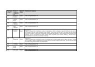
SHLAA 2010 - <strong>Measham</strong> <strong>and</strong> <strong>Appleby</strong> <strong>Magna</strong><br />
M3<br />
M5<br />
M4<br />
M10<br />
Oa1<br />
M11<br />
Oa2<br />
M9<br />
M2<br />
M1<br />
Stretton-en-le-Field<br />
<strong>Measham</strong><br />
M8<br />
M7<br />
M6<br />
Ap1<br />
Ap2<br />
Ap3<br />
<strong>Magna</strong><br />
Snarestone<br />
Key - SHLAA 2010<br />
Overlaying Areas<br />
Deleted Sites<br />
´<br />
0<br />
Ap4<br />
500<br />
1,000 2,000<br />
Meters<br />
North West Leicestershire District Council<br />
- Spatial Planning -<br />
Included Sites<br />
Reproduction from Ordnance 1:1250 mapping with permission of the Controller of HMSO<br />
Crown Copyright. Unauthorised reproduction infringes Crown Copyright <strong>and</strong> may lead to<br />
prosecution or civil proceedings Licence No: 100019329