Norton Common - Hertfordshire County Council
Norton Common - Hertfordshire County Council
Norton Common - Hertfordshire County Council

You also want an ePaper? Increase the reach of your titles
YUMPU automatically turns print PDFs into web optimized ePapers that Google loves.
Kite Way<br />
A1(M)<br />
1<br />
2<br />
3<br />
4<br />
5<br />
Arlesey New Road<br />
Icknield Way Path<br />
to Ivinghoe Beacon<br />
Stotfold Road<br />
Wilbury Hills Road<br />
Hitchin<br />
A<br />
Garden City Greenway<br />
Fearnhill<br />
School<br />
Stotfold Road<br />
Wilbur y Hills<br />
Icknield Way<br />
Stotfold Road<br />
Standalone Farm<br />
Wilbury Road<br />
Bedford Road<br />
Eldefield<br />
Icknield Infant &<br />
Nursery School<br />
Icknield Way Path<br />
Campfield<br />
Way<br />
Bursland<br />
Letchworth<br />
A505<br />
Valley Road<br />
Garden<br />
Garden City Greenway<br />
Standalone<br />
Farm<br />
Wilbury<br />
Junior School<br />
Chiltern View<br />
Runnalow<br />
Archers<br />
Icknield Way<br />
Burnell Rise<br />
High Avenue<br />
St Thomas More<br />
Primary School<br />
The Highfield School<br />
Briar Patch<br />
Lane<br />
Way<br />
Hitchin Road<br />
Campers<br />
Highfield<br />
City Greenway<br />
Stonehill School<br />
Southern<br />
Long mead<br />
Wilbury Road<br />
Bedford Road<br />
Redhoods Way W.<br />
Road<br />
Campers Avenue<br />
West View<br />
Oak Tree Close<br />
B C D E F G<br />
Southern Way<br />
Icknield Way Path<br />
Spirella<br />
Building<br />
Station Way<br />
Spring Road<br />
St Francis College<br />
Sollershott West<br />
Pasture<br />
Way<br />
Road<br />
Baldock Road<br />
Pasture Road<br />
Western<br />
Broadway<br />
Way<br />
Letchworth<br />
Golf Course<br />
Garden City Greenway &<br />
Great North Way - NCN Route 12<br />
to Stotfold, Henlow<br />
Broadway<br />
Garth Road<br />
Letchworth<br />
Gaunts Way<br />
Southfields<br />
Midhurst<br />
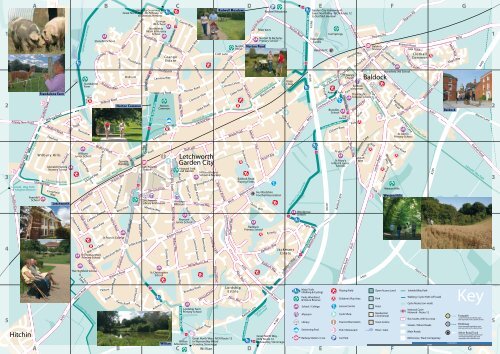
<strong>Norton</strong> <strong>Common</strong><br />
Hawthorn Hill<br />
Broadwater Avenue<br />
West View<br />
Bridge<br />
Rd<br />
Broadway<br />
Sollershott East<br />
Lane<br />
Grange<br />
Letchworth<br />
Station<br />
Grange<br />
JM School<br />
Northfields<br />
Infant & Nursery<br />
School<br />
Northfields<br />
Road<br />
Ordelmere<br />
Nevells Road<br />
Field Lane<br />
The<br />
Quadrant<br />
Danescroft<br />
<strong>Norton</strong><br />
<strong>Common</strong><br />
Icknield Way<br />
Gernon Road<br />
Letchworth<br />
Library & Museum<br />
St Christopher<br />
School<br />
Grange<br />
Estate<br />
Southfields<br />
Lammas Way<br />
Wilbury Road<br />
Leys Avenue<br />
Meadow Way<br />
South View<br />
Great North Way<br />
Aubreys<br />
Letchworth Lane<br />
Willian Road<br />
Open air<br />
Cloisters Road<br />
Aubreys<br />
Willian<br />
Sparhawke<br />
Northfields<br />
<strong>Norton</strong> Way South <strong>Norton</strong> Way South<br />
Rushby<br />
Howard Park<br />
and Garden<br />
Heritage<br />
Museum<br />
Pixmore<br />
Junior School<br />
Baldock Road<br />
Willian Way<br />
Eastern Way<br />
<strong>Norton</strong> Way North<br />
Mead<br />
Gaunts Way<br />
Willian<br />
Arboretum<br />
<strong>Norton</strong><br />
Lordship Farm<br />
Primary School<br />
Icknield Way Path<br />
Letchworth<br />
Garden City<br />
Hillshott<br />
Willian Way<br />
Great North Way<br />
Eastern Way<br />
Birds Hill<br />
Shott Lane<br />
Rushby<br />
Road<br />
<strong>Common</strong> View<br />
Mead<br />
Cashio Lane<br />
Ridge Avenue<br />
Lawrence Avenue<br />
Brandles Road<br />
Glebe Road<br />
Icknield Way<br />
Hillshott Infant<br />
School & Nursery<br />
Broughton Hill<br />
Pixmore Way<br />
Bowershott<br />
A505<br />
Whitethorn Lane<br />
Howard<br />
Willian Road<br />
Lordship<br />
Drive<br />
Lane<br />
Howard Drive<br />
Radwell Meadows<br />
Croft Lane<br />
Pixmore Avenue<br />
<strong>Norton</strong> Road<br />
North Avenue<br />
Great North Way - NCN Route 12<br />
to Wymondley Wood<br />
Graveley, Stevenage<br />
Willian<br />
<strong>Norton</strong><br />
Pond<br />
<strong>Common</strong> View<br />
Letchworth Gate<br />
Works Road<br />
B656<br />
Radburn Way<br />
Glebe Road<br />
Lordship<br />
Estate<br />
Penn Way<br />
Dunhams<br />
Lane<br />
Baldock Road<br />
Playing Fields<br />
Penn Way<br />
Avenue<br />
Baldock Road<br />
A505<br />
Green Lane<br />
Radburn<br />
Primary School<br />
Baldock Lane<br />
Nor ton<br />
<strong>Norton</strong> Road<br />
<strong>Norton</strong> Pond<br />
Great North Way<br />
One<br />
Quinn<br />
Radwell Meadows<br />
<strong>Norton</strong> St Nicholas<br />
Primary School<br />
Icknield Way Path<br />
Blackhorse Rd<br />
<strong>Hertfordshire</strong><br />
Football Association<br />
Way<br />
Second Ave<br />
Radburn Way<br />
Radburn<br />
Letchworth Gate<br />
Garden City<br />
Greenway<br />
Kyrkeby<br />
Way<br />
Works Road<br />
Great North Way -<br />
NCN Route 12<br />
to Graveley, Stevenage<br />
Jubilee Road<br />
Jack mans<br />
Estate<br />
A1(M)<br />
<strong>Norton</strong> Road<br />
Knap<br />
Close<br />
Radburn Way<br />
Garden City<br />
Garden City Greenway<br />
Baldock Road<br />
Greenway<br />
Great North Way<br />
B656<br />
Woolgrove<br />
School<br />
A1(M)<br />
A1(M)<br />
Pryor Way<br />
Garden City Greenway &<br />
Great North Way - NCN Route 12<br />
to Stotfold, Henlow<br />
Equestrian<br />
Centre<br />
Baldock Lane<br />
Great North Way<br />
Baldock FC<br />
Major Trails<br />
(Walking & Cycling)<br />
Ivel Springs<br />
Icknield Way Path<br />
West Avenue<br />
Pepys Wy<br />
Avenue Park<br />
Letchworth Road<br />
<strong>Norton</strong><br />
Road<br />
Brandles<br />
School<br />
Fire<br />
Station<br />
St Mary’s<br />
Church<br />
St Mary's<br />
Infant & Junior<br />
Schools<br />
Baldock Lane<br />
North Road<br />
Icknield<br />
Hitchin St<br />
Weston Way<br />
ChilversBank<br />
St<br />
Park St<br />
Weston Way<br />
London Road B197<br />
Way<br />
Baldock<br />
Museum<br />
Station Rd<br />
Pond Lane<br />
Orchard Rd<br />
Mary’s Way<br />
The Knights<br />
Templar School<br />
Mansfield Rd<br />
Crabtree<br />
Willian<br />
Way<br />
Whitehorse St<br />
Baldock<br />
Station<br />
Baldock<br />
A505<br />
Lane<br />
Bygrave Rd<br />
High Street<br />
NightingaleWay<br />
Icknield Way Path<br />
London Road<br />
Chalk Hills<br />
Royston Road<br />
California<br />
Grosvenor Rd<br />
Hartsfield JMI School<br />
1 mile<br />
A B C D E F G<br />
Parks, Woodland<br />
& Nature Reserve<br />
School / College<br />
Museum<br />
Library<br />
Swimming Pool<br />
Railway Station / Line<br />
Great North Way<br />
Playing Field<br />
Park<br />
Children’s Play Area<br />
Leisure Centre<br />
Cycle Shop<br />
Tourist Information<br />
Pub / Restaurant<br />
Car Park<br />
Drive<br />
Woodland<br />
Way<br />
Chiltern Road<br />
Clothall Road<br />
Pembroke<br />
Road<br />
Pinnocks Lane<br />
Weston Hills<br />
Open Access Land<br />
Park<br />
Field<br />
Residential<br />
Commercial<br />
Town Centre<br />
River / Lake<br />
Bygrave Rd<br />
Royston Road<br />
South Road<br />
Lime Kiln Lane<br />
St John's<br />
Primary School<br />
Pryor Road<br />
Weston Hills<br />
Sale Drive<br />
Clothall<br />
<strong>Common</strong><br />
Yeoma nry D rive<br />
Icknield Way Path<br />
Hatch Lane<br />
Icknield Way Path<br />
Wallington Road<br />
A507<br />
A505<br />
Walking / Cycle Path (off-road)<br />
Cycle Routes (on-road)<br />
National Cycle<br />
Network - Route 12<br />
Bus routes, with bus stop<br />
Streets / Minor Roads<br />
Main Roads<br />
Motorway / Dual Carriageway<br />
Saxon Way<br />
B656<br />
Aleyn Way<br />
Baldock<br />
1 kilometre<br />
A505<br />
Warren Lane<br />
Clothall Road<br />
Icknield Way Path<br />
Key<br />
Footpath<br />
(route normally marked by signs<br />
and waymarks with a yellow arrow)<br />
Bridleway<br />
(route normally marked by signs<br />
and waymarks with a blue arrow)<br />
Minor Road, Track<br />
(roads used as a public path route<br />
normally marked by signs and<br />
waymarks with a black arrow)<br />
1<br />
2<br />
3<br />
4<br />
5