Natura 2000 sites Map of Natura 2000 sites in the <strong>Macaronesian</strong> <strong>Region</strong> The list of Natura 2000 sites for the <strong>Macaronesian</strong> <strong>Region</strong> was the first to be adopted in December 2001 and later updated in January 2008. Altogether, within the <strong>Macaronesian</strong> <strong>Region</strong> there are 211 Sites of Community Importance (SCIs) under the Habitats Directive and further 65 Special Protection Areas (SPAs) under the Birds Directive. There is often considerable overlap between some SCIs and SPAs which means that the figures are not cumulative, nevertheless, it is estimated that together they cover more than a third of the total land area in this region. Number of habitat types in Annex I and species or sub-species in Annex II of the Habitats Directive. <strong>Region</strong> Habitat types Animals Plants Atlantic 117 80 52 Boreal 88 70 61 Continental 159 184 102 Alpine 119 161 107 Pannonian 56 118 46 Steppic 25 25 14 Black Sea 58 79 6 Mediterranean 146 158 270 <strong>Macaronesian</strong> 38 22 159 Source: European Topic Centre on Biological Diversity (European Environment Agency) http://biodiversity.eionet.europa.eu – The figures are not cumulative since many habitats and species occur in two or more biogeographical regions – Birds from Annex I of the Birds Directive are not listed as they are not categorized according to biogeographical region <strong>Region</strong> N° SCI Total area covered (km²) Terrestrial area covered (km²) % of total terrestrial area Source: European Topic Centre on Biological Diversity (European Environment Agency) http://biodiversity.eionet.europa.eu October 2008 – SPAs and SCIs are not cumulative as there is considerable overlap between them – Some sites are on the border between two regions, the database does not allow for the possibility to split sites between regions, therefore some sites may be counted twice – Percentage of marine areas not available – SPAs are not selected according to biogeographical region – SPA area for the Steppic <strong>Region</strong> are calculated according to available GIS data N° SPA Total area covered (km²) Terrestrial area covered (km²) % of total terrestrial area Atlantic 2,747 109,684 68,794 8.7 882 76,572 50,572 6.4 Boreal 6,266 111,278 96,549 12.0 1,165 70,341 54,904 6.8 Continental 7,475 150,014 135,120 10.8 1,478 147,559 128,432 12.4 Alpine 1,496 145,643 145,643 39.7 365 93,397 93,397 31.1 Pannonian 756 15,858 15,858 12.3 100 19,965 19,965 17.5 Steppic 34 7,210 7,210 19.4 40 8,628* 8,628 24.4 Black Sea 40 10,243 8,298 71.8 27 4,100 3,561 30.8 Mediterranean 2,928 188,580 174,930 19.8 999 147,358 142,350 16.0 <strong>Macaronesian</strong> 211 5,385 3,516 33.5 65 3,448 3,388 32.3 TOTAL 21,612 655,968 568,463 13.3 5,004 486,571 429,615 10.5 6 Natura 2000 in the <strong>Macaronesian</strong> <strong>Region</strong>
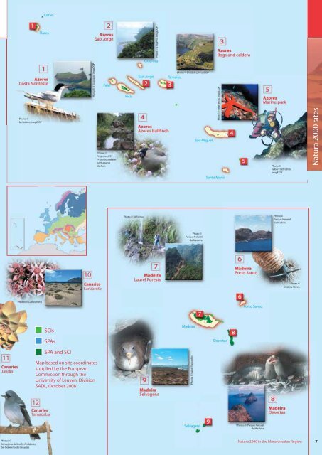
Natura 2000 sites SCIs SPAs SPA and SCI Map based on site coordinates supplied by the European Commission through the University of Leuven, Division SADL, October 2008 Natura 2000 in the <strong>Macaronesian</strong> <strong>Region</strong> 7