
You also want an ePaper? Increase the reach of your titles
YUMPU automatically turns print PDFs into web optimized ePapers that Google loves.
<strong>Canadian</strong> <strong>Rail</strong> ~<br />
No.410<br />
MAY-JUNE<br />
<strong>1989</strong>
74<br />
CANADIAN ~IL<br />
~--,-,----------------------------------------------- ISSN~'4 815 -----------<br />
PUB LISHED al·MONTHl Y BY THE CANAOIAN RAILROAD HISTORICAL ASSOCIATION<br />
EDITOR: Fred F. Angus<br />
For your membership in the CRHA w hich includes a<br />
CO-EDITOR : Douglas N. W. Smith subscription to <strong>Canadian</strong> <strong>Rail</strong> write 10:<br />
PRODUCTION : M. Peter Murphy CAHA, P.O. Box 148. St. Constant, Quebec J 5A 2G2<br />
CARTOGRAPHER: William A. Germaniuk Rates: in Canada ........ .......... ........ .... $27.<br />
LAYOUT: Fred F. Angus outside Canada: . . ...... $23. in U.S. FUNDS.<br />
TYPESETTING : Belvedere Pholo·GraphiQue Inc.<br />
PRINTING: Pracer Priming<br />
COVERS' Grant Printing<br />
~~~~~~L-----------TABLEOFCONTENTS-------------------.<br />
FIFTIETH ANNIVERSARY OF THE 1939 ROYAL TOUR<br />
THE NAKUSP & SLOCAN RAILWAY<br />
ALGOMA CENTRAL. 1982 ...<br />
PAGES FROM THE PAST (ANNIVE RSARI ES IN MAY - JUNE <strong>1989</strong>)<br />
RAIL TR ACK MILEAGE IN AL8ERTA 1883 - 1915<br />
RAIL CANADA DECISIONS<br />
8USINESS CAR<br />
DOUGLAS N.W. SMITH 75<br />
DOUGLAS N.W. SMITH<br />
GORDON TAYLOR<br />
..... ........ .. FRED ANGUS<br />
.... DESMOND H. BROWN<br />
DOUGLAS N.W. SMITH<br />
81<br />
89<br />
92<br />
97<br />
101<br />
106<br />
•<br />
<strong>Canadian</strong> Aall IS continually in need of news. slories. historical data. photos. maps and other reproduclibl e material. Please send atl<br />
con'"h"t,ons to the editor' Fred F, Angus. 3021 Trafalgar Ave. Montreal. P.O. H 3Y 1 H 3. N o payment can be milde for tontributions. but<br />
the conlr lhutor WIll l It: gIven credit for m atenal submiHed. Mate,, ~ 1 Will bf! returned to the contrib UlOr If requested. Remember . "KnOwledge is<br />
ot lin le v81ue unless rt is shared Wilh other\l"<br />
Frederick F. Angus<br />
R.C. Ballard<br />
Jack A. Suny<br />
Waller J . Sedbrook<br />
Alan C. Blackburn<br />
Charles Oe J ean<br />
Gerard Frechette<br />
• NATIONAL DIRECTORS·<br />
W illiam Hrynkow<br />
David W. Johnson<br />
J. Christopher Kyle<br />
Bernard Martin<br />
Robert V. V. Nicholls<br />
Andrew W. Panko<br />
Douglas N.W. Smith<br />
OelYk Sparks<br />
Oavid W. Strong<br />
laurence M . Unwin<br />
Richard Viberg<br />
A. Stephen Walbridge<br />
John C. Weir<br />
The CAHA h'" II number of IOC81 d lvis;Ot'Is IICroSS Ih e country. M,nv hord regular<br />
meetIngs and issue newslellers. Funher informal.on m ay be obt~il'le-d by WIlting to the<br />
dlviSI()n .<br />
• NEW f!~UNSWIC" DiVISION<br />
PO. S". 1162<br />
SI I ~t John.<br />
New Bnrnlwl(k E2l 4G7<br />
• SI . L/lWAENCE VALLE Y DiVISION<br />
P.O. Bo. 22 S'."on 'S'<br />
Mantrell. au. H3B 3 J~<br />
• RIDEAU VIlLLEY 01'115:00<br />
PO Su.962<br />
S","n, Fi n,. On.~r'" K-'''' SAS<br />
• "INGSTON O1'11SION<br />
P.O, 80_ 103. StillIon ~A <br />
"i"9lloo. OntarIo "7M 6P9<br />
• TOI1ONfO ... YORK OIVlSlON<br />
P,l) 80' 5849, T.rm,~. 1 A,<br />
TOfOntO.On""o M5W lP3<br />
• N1"'G ... AA DIVIS ION<br />
PO, 8" . 593<br />
$1. Cflhlnn". Onl."o UA I5we<br />
• """""OSOR ·ESSEX DIVISION<br />
300 C.blnl Atnd Eu •.<br />
W'_Of. Ontino N9G 1"'2<br />
• KEYSTOI\[ DIVISION<br />
14 Revnolrit 88V<br />
Wlnn'p"g. Ma MobiI R3I\ OM4<br />
• C"lGARV" SOUTH WESTERN DI'IIS ION<br />
60 - 6100. 41h A .... NE<br />
C.llIory, Albi!.t~ T2A 5ZB<br />
• AOCKY MOUNTA IN DIVI SIO N<br />
PO. 80. 61 02. 51.""" C.<br />
Edln Columl).. V6C 2P 1<br />
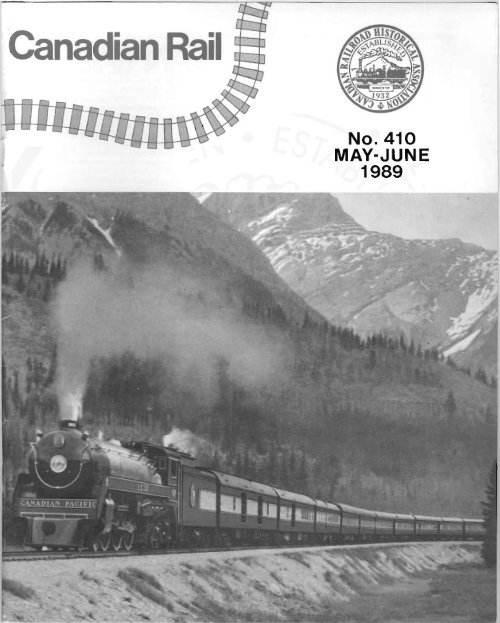
FRONT COVER:<br />
CP Huds-on 2850 if, dr_mg me Roy./ Tfllin<br />
rtItough '''' Hicking Horse Pus " Le,ncfl.oil.<br />
8",,*h Columbi, tuMe,fh Ih' .roow covered<br />
.umrmt. of Mount. VIU:OC .fJd i liff;' lind Chifflcellor<br />
Pe,A. 71>1S hond- coItxffIId view WIIS I.ken tN> MIJ'f<br />
28. 1939 ond ~.,ed (HI (h, ('ove~ 01 CP diNilg<br />
e.f m.mls.<br />
ColI,ellon of Doug/" N. W. Smlrh.<br />
71>, CRHA wisllrs /0 .cknow/'d(Je donillion~ by<br />
C.f.ld E. G, u{J/ ,nd Doug/.s N, W. Smlill wllich<br />
h'/p,d ID fund Ille . ddmon.1 costs of th" inul's<br />
",,/our COVfIf. 71>i$ m.rk, me "cond tim' in the<br />
hiJftlrf of m. As.sod.rion Ih'f C,m.dlltn <strong>Rail</strong> hilS<br />
hid , coIoUf COY".<br />
Alii pan o f its activities. Ihe CRHA operates<br />
the Canilfllan RilllwlIy Museum at Delson/ 51.<br />
Con5T~nt. a ueblt~ which t$ 14 mIles (23 Km .,<br />
from downtown Mont.eal . It is open d
80<br />
ROYAL TOUR<br />
REGAL in appearance, luxurious in<br />
interior decorations and appointments, the history-making royal train in which<br />
His Majesty King George VI and Her Majesty Queen Elizabeth travelled across<br />
Canada for a month was the most unusual home in which any British Sovereign<br />
ever resided for an extended period.<br />
The train was in every way a home and a palace. Its fittings included the<br />
newest developments in railway equipment and every known device calculated<br />
to assure the safety of Their Majesties and to make their long journey comfortable<br />
and enjoyable.<br />
<strong>Canadian</strong> Pacific <strong>Rail</strong>way locomotive 2850, which hauled the royal train from<br />
Quebec City to Vancouver, is one of the most efficient wheeled-powerhouses<br />
in the world. In accomplishing this journey of approximately 3,100 miles, with<br />
aid over only the steepest grades of the <strong>Canadian</strong> Rockies, and without mechanical<br />
trouble of any kind, locomotive 2850 established a notable record.<br />
No other <strong>Canadian</strong> locomotive eVer presented a more striking appearance<br />
than No. 2850 on the tour. A mass of shining stainless steel, relieved by royal<br />
blue, silver and gold, her semi-streamlined front bore the Royal Arms over the<br />
headlight; Imperial Crowns decorated each running board; the crest of the<br />
<strong>Canadian</strong> Pacific <strong>Rail</strong>way Company appeared beneath the window of the cab,<br />
and on the tender the Royal Arms, four feet high, were blazoned in relief.<br />
The <strong>Canadian</strong> Pacific <strong>Rail</strong>way Company proudly accepted the privilege of<br />
serving Their Majesties in a variety of ways. The Royal Visitors came to Canada<br />
in the <strong>Canadian</strong> Pacific liner Empress of Australia, travelled westward<br />
across the Continent over the Company's rail lines, rested for two days at Banff<br />
Springs Hotel in the <strong>Canadian</strong> Rockies, and attended sta~e luncheons and<br />
dinners in the Chateau Frontenac at Quebec City and the Empress Hotel in<br />
Victoria, British Columbia. They crossed from Vancouver to Victoria in the<br />
steamship Princess Marguerite of the Company's British Columbia coastal<br />
fleet and returned to England in the palatial Empress of Britain, flagship of<br />
the <strong>Canadian</strong> Pacific flee!. In radio, <strong>Canadian</strong> Pacific Communications were<br />
used by the <strong>Canadian</strong> Broadcasting Corporation to transmit and distribute<br />
graphic descriptions of events and scenes during the Royal Tour, and across<br />
<strong>Canadian</strong> Pacific wires and cables modern magic flashed telephotos of the<br />
Royal Visit.<br />
The Royal Tour was a truly historic event in which the <strong>Canadian</strong> Pacific<br />
<strong>Rail</strong>way Company played a notable part.<br />
CANADIAN PACIFIC<br />
World's Greatest Travel System<br />
Source: CPR Dmmg Car Menu : 1939.
81<br />
The Nakusp & Slocan <strong>Rail</strong>way:<br />
Early <strong>Rail</strong>way Days in the Kootenays<br />
by Douglas N .W . Smith<br />
On December 1,1988, the National Transportation Agency<br />
(the Agency) authorized CP to abandon its line between Nakusp<br />
and Rosebery ,BC, a distance of 27 miles . This abandonment is<br />
of more than passing interest as it marks the end of a colourful<br />
era when two titans of the Victorian railway world clashed over<br />
the shipments from the silver mines of the Western Kootenays.<br />
Late in the fall of 1891, a group of prospectors were enroute<br />
to Ainsworth, BC when they came across an outcropping of ore<br />
near Carpenter's Creek. The assay proved the ore to be rich in<br />
silver. The following year the rush commenced to exploit the<br />
Slocan district find . Ore production began in 1892 at the<br />
"Freddie Lee" mine near Sandon. The ore was packed on<br />
horses from Sandon to New Denver from where it was shipped in<br />
flat bottomed boats to the head of Slocan Lake. From there, it<br />
moved by pack train to Nakusp where it was forwarded to<br />
smelters on steamboats of the Columbia & Kootenay Steam<br />
Navigation Company . When the provincial government refused<br />
to built a 20 mile pack trail from Slocan Lake to Nakusp, the<br />
pack trains commenced to use the shorter trail to Kasl0.<br />
Up to the early 1890's, the Kootenay region had very<br />
rudimentary transportation arteries . The CPR transcontinental<br />
line passed to the north of the region and the Great Northern<br />
(GN) main line to the south in the United States. The only<br />
railway in the lower Kootenays was the Columbia & Kootenay<br />
<strong>Rail</strong>way (C&K) which extended from Nelson to Sproats<br />
Landing. The C&K had been chartered in 1890 and was built in<br />
1891 . CP had acquired the line under a 999 year lease in 1890 .<br />
Steamboats were the main means of transport through the<br />
region. They provided access to the CP line at Revelstoke, To<br />
GN line at Bonner's Ferry, Idaho, and to the Spokane Falls &<br />
Northern at Northport, Washington.<br />
Following the silver find , American capitalists quickly<br />
moved into the Kootenays. The trade of the region was<br />
inexorably drawn southwards. Given the lack of good transportation<br />
links to the BC coast, it appeared that this rich area would<br />
come completely with the American sphere of influence.<br />
These fears were magnified when construction began on the<br />
Nelson & Fort Sheppard <strong>Rail</strong>way (N &FS) began in 1893 . The<br />
N&FS would form the <strong>Canadian</strong> portion of a rail line between<br />
Nelson and Spokane, Washington. At Spokane, connections<br />
would be made with the Great Northern. As the first all-rail<br />
route into the Kootenays , the N &FS threatened to siphon all<br />
traffic of the region into the United States .<br />
J .A. Mara, MP for the Kootenay area wrote to the<br />
Dominion Minister of <strong>Rail</strong>ways and Canals, the Honourable<br />
John Haggart on April 20, 1893, "Already there is a rush into<br />
West Kootenay, but the whole ofthetrade is with the south. Not<br />
a man nor a pound of freight has gone into the country from<br />
Canada for over 5 months. Another year like this and Canada<br />
might as well throw up the sponge and let the Americans have<br />
what might be the most profitable business on the main line of the<br />
CPR . .. The contract is let for the Nelson & Fort Sheppard<br />
<strong>Rail</strong>way and the work is being pushed vigourously".<br />
The construction of the N &FS brought matters to a head.<br />
Faced with a tight financial situation and the ominous signs of an<br />
economic recession, the CPR could not afford to finance the<br />
construction of rail lines into the district. In 1893, under<br />
pressure from mining interests and the Vancouver Board of<br />
Trade which viewed with alarm the American advances into its<br />
trading hinterland, the BC government voted to guarantee the<br />
interest upon a construction cost of $ 25,000 per mile for the<br />
Nakusp & Slocan <strong>Rail</strong>way (N&S) provided the federal<br />
government accorded the N &S a subsidy of $ 3,200 per<br />
mile .<br />
In his letter of April 20, 1893, J.A. Mara, MP urged the<br />
Dominion Minister of <strong>Rail</strong>ways and Canals to have the federal<br />
government not to wait for a vote in Parliament but to pass an<br />
Order in Council approving the subsidy to the N &s. The BC<br />
Minister of Finance was on his way east to see if the bonds of the<br />
N&S could be floated. Financial markets would be more<br />
favourable to the N &S project if the federal subsidy money was<br />
committed. Mara noted, "The telegram you sent to the<br />
Lieutenant Governor served its purpose as without that the<br />
Provincial Government would have deferred action till the next<br />
session, but the telegram can not be used with capitalists nor<br />
would it be considered binding upon your government" .<br />
On August 3,1893, the N&S and CP signed an agreement<br />
whereby CP leased the line for 25 years with CP to take<br />
possession upon completion of the line. CP agreed to pay a<br />
rental equal to 40% of the line's revenues. With this agreement<br />
in hand, the N &S signed a contract with the Inland Construction<br />
and Development Company on August 16, 1893. The contract<br />
stipulated that the 38 miles line between Nakusp and Three<br />
Forks was to be completed by December 31, 1894 . In order to<br />
issue the bonds necessary to finance construction, the BC<br />
government agreed to guarantee the bonds provided the<br />
company deposited the equivalent of the expected federal<br />
railway subsidy in the Bank of British Columbia. The Dominion<br />
government voted the subsidy in July 1894.<br />
On October 3 1893, the steamer "Kootenai" brought leased<br />
CPR locomotive 403 on a scow from Revelstoke to Nakusp. By<br />
the end of 1893, track laying had commenced from Nakusp. On<br />
May 15, 1894, the Dominion Minister of <strong>Rail</strong>ways and Canals<br />
approved the request made on May 8th by the Inland
82<br />
Construction and Development Company to operate freight and<br />
passenger service over the completed portion of the line.<br />
Nelson's newspaper, "The Miner", reported on September<br />
22, 1894 that the N&S was completed from Nakusp to New<br />
Denver and on October 27th commented that the rails were<br />
within 114 miles of Three Forks . On November 24th, G .J.<br />
Desbarats, one of the Dominion Government's Inspecting<br />
Engineers, filed a report on the new line. This report is<br />
reproduced in Appendix I. On December 1st, "The Miner"<br />
stated that the first passenger train had passed over the entire<br />
N &S line carrying various officials of the CPR. On December<br />
20th, CP took the line over from the construction company.<br />
While the N &S was pushing on to Three Forks, CP had been<br />
taking steps to improve its access to the Kootenays. During the<br />
winter months when water levels in the Columbia River fell, the<br />
steamboats of the Columbia & Kootenay Steam Navigation<br />
Company (CKSN) had trouble reaching Revelstoke. In 1894,<br />
CP constructed a branch line along the Columbia to by-pass the<br />
worse stretches of the river. On September 18, 1894, Desbarats<br />
reported that the branch to Wigwam was nearing completion.<br />
The troubles with the Columbia River were not to be overcome<br />
so easily. An item in "The Miner" dated January 5, 1895 stated<br />
that the Columbia River was closed to navigation and ores<br />
moving from N akusp to Revelstoke were being handled by sled<br />
the 15 miles from the mouth of the Columbia to Wigwam.<br />
Having found the terminus at Wigwam unsuitable, CP let a<br />
contract in September 1895 to extend the branch from Wigwam<br />
to a community called Arrow Head at the mouth of the<br />
Columbia River . Desbarats report on the progress of the<br />
extension on December 14, 1895 is in Appendix II.<br />
In a subsequent report to the Dominion Government dated<br />
March 16, 1896, Desbarats stated that a 60 foot x 30 foot<br />
station and a 60 foot x 24 foot freight shed had been erected at<br />
Arrow Head. The spur track built on the wharf had a 2% grade<br />
to enable the boats to unload at any level of water. While<br />
ballasting was not yet completed, the line was deemed<br />
sufficiently safe to open if train speeds were kept to 12 miles per<br />
hour. Apparently, CP had started moving traffic over the line<br />
prior to this date as the February 8, 1896 issue of "The Miner"<br />
reported the "Nakusp" had been especially busy since the<br />
completion of the Arrow Head branch to the lake. As an<br />
example, it stated that on February 1st, the steamer took 240<br />
tons of ore to Arrow Head. The CKSN built the tug<br />
"Columbia" in 1896 to power rail car barges on the Arrow Lake<br />
service to relieve the steamboats of this duty.<br />
While the completion of the branch to Arrow Head<br />
eliminated the troubles from low water, the Columbia River was<br />
not completely vanquished. In June 1896, it flooded the Arrow<br />
Head Branch. The damage was so severe, the line was not<br />
reopened until the end of September.<br />
As had been the case at Revelstoke, low water levels in the<br />
Columbia River had made winter navigation very difficult to the<br />
C&K terminal at Sproats Landing. In 1895, the C&W built to<br />
0.7 mile spur off its main line to have a reliable year round<br />
connection with the steamboats. On December 14, 1895<br />
Desbarats reported that the spur was in operation and would be<br />
used only between December and April during the period oflow<br />
water.<br />
A view of the bustling burg of Nakusp from one of CP's steamers.<br />
On the wharf the consist of the mixed train awaits the arrival of the<br />
vessel to begin transferring freight, mail express and passengers.<br />
Credit: National Archives of Canada/PA 30830.<br />
Marking the end of the first phase of its expansion into the<br />
Kootenays, CP purchased the CKSN in December 1896 and<br />
took possession on February 1, 1897. The CKSN steamboats<br />
linked the Arrow Head branch totheN &S and the C&W as well<br />
to the new smelter at Trail.<br />
The owner of the smelter, Augustus Heinze, built the narrow<br />
gauge Trail Creek Tramway (TCT) to link his smelter to the<br />
mines in Rossland in 1896 . The following year, Heinze<br />
completed the Columbia & Western <strong>Rail</strong>way (C&W) from<br />
Trail to West Robson. This was the first section of a projected<br />
new railway to the BC coast. In comre the owner of the N &FS<br />
built an extension from the Nelson-Spokane line to Rossland.<br />
Known as the Red Mountain <strong>Rail</strong>way, this line reached<br />
Rossland in 1896.<br />
In 1897, CP began the construction of its line from<br />
Lethbridge to the Kootenays. Eventually, this would become<br />
CP's second line across BC . As part of this project, CP took<br />
over the C&W and TCT in 1898. Heinze insisted that CP<br />
purchase the smelter. Reluctantly, CP agreed and thus came<br />
into being CP's interest in the Consolidated Mining &<br />
Smeltering Company. The G N expanded its access to the region<br />
by acquiring the N&FS and Red Mountain in 1898 .<br />
While CP had been strengthening its system in the<br />
Kootenays, the Great Northern was not sitting idly by. The GN<br />
had completed its transcontinental line in 1893. GN President<br />
James Hill was out to secure all the traffic he could, while CP<br />
President Van Home was determined to best Hill . The Slocan<br />
district mine traffic proved to be one of the areas where these two<br />
locked horns.<br />
Round One seemingly went to Hill. In April 1895, he began<br />
construction of the Kaslo & Sandon <strong>Rail</strong>way (K&S). This three<br />
foot narrow gauge line was aimed right at the heart of the Slocan<br />
mining region. In order to link the K&S to his system, the GN
83<br />
organized the International Navigation & Trading Company in<br />
1895 . Its steamboats sailed from Kaslo to Bonners Ferry,<br />
Idaho where connections were made with the Great Northern<br />
main line and to the new smelter at Nelson.<br />
CP was not slow to meet this challenge. In June construction<br />
began on an extension of the N &S from Three Forks to Sandon.<br />
The K&S reached Sandon on October 23, ] 895, while the<br />
N&S arrived on December 12,1985 . The two companies were<br />
in combative mood. The K&S alleged the N &S was trepassing<br />
on its lands in Sandon. On the night of December 13th, K&S<br />
crews demolished the N&S station in Sandon. The events of<br />
that night came to be known as the" <strong>Rail</strong>way War at Sandon" .<br />
The account of the event as reported in "The Miner" is<br />
reproduced in Appendix III.<br />
In order to shorten the distance from the Sandon mines to the<br />
Nelson smelter, CP decided to build a 31 mile branch line from<br />
Slocan Junction on the C & W to Slocan City at the southern end<br />
of Slocan Lake. This line was built under the charter of the<br />
C&W. In February 1896, surveyors were in the field locating<br />
the line . Construction of a steamboat and car barge for use on<br />
Slocan Lake to connect the N &S and the new branch line as well<br />
as clearing land for the branch line commenced in January 1897.<br />
The laying of rails began in mind August. On November 20,<br />
1897, "The Miner" announced that the last rail had been laid on<br />
the branch. The line was opened for service on December 1st,<br />
but the official opening trip was delayed from December 1st to<br />
the 6th due to poor weather.<br />
CP built the steamboat" Slocan" in 1897. It was the first CP<br />
vessel on the Siocan Lake. The following year the passenger tug<br />
" Sandon" was launched and assumed the duties of moving the<br />
rail car barge between Slocan City and Rosebery. The<br />
"Sandon" was replaced in 1928 by a new passenger tug, the<br />
" Rosebery". The first "Rosebery" was replaced by another<br />
passenger tug of the same name in 1943. In 1956, CP retired the<br />
"Rosebery" . A new tug, the "In's G" , took over. This vessel<br />
was operated by a private firm under a contract with CP.<br />
The K&S, which initially handled the largest volume of ore<br />
shipments from the Slocan mines, was to have a short life span.<br />
In 1909, slides closed the line between McGuigan and Sandon.<br />
The following year, fires wiped out several of the major mines<br />
along the line leading to a suspension of service. The GN had<br />
formed the Kootenay <strong>Rail</strong>way & Navigation Company in 1898<br />
which had as its assets the K&S as well as the International<br />
Navigation & Trading Company steamboats. With the closure<br />
of the K&S , the GN withdrew from the steamboat business.<br />
Following an accident to the" Kaslo" in May 1910, the fleet of<br />
steamboats was laid up.<br />
Following the sale of the K&S to a group of local citizens, it<br />
re-opened in 1911. It was transferred to the provincial<br />
government in 1912 who turned it over to CP that year. CP built<br />
a line from Parapet, a point near Three Forks, to Zincton in<br />
1912. At Zincton a connection was made with the K&S. The<br />
K&S line from Zincton to Kaslo was converted to standard<br />
gauge. On July I, 1914, CP ran its first passenger train from<br />
Nakusp to Kaslo. Floods in 1955 lead to the abandonment of the<br />
line between Denver Canyon in 1957.<br />
Steamboat service over the Arrow Lakes between Arrow<br />
Head and Robson via Nakusp came to an end in April 1954<br />
Major <strong>Rail</strong> Lines in the Kootenays<br />
1897<br />
U SA<br />
TO SPOI
84<br />
CP had the steamer "Kootenay" built in the shipyards at Nakusp. It entered service in 1897 running from Arrow Head to Robson<br />
via Nakusp. The 184 foot long stem wheeler made a handsome sight as it forged together the railway system CP was pUlling<br />
together in the later 1890 's in the region. This view shows the "Kootenay" tied up at the wharf at its birthplace. The Nakusp<br />
station and freight shed are the buildings to the right of steamer.<br />
Credit: CP <strong>Rail</strong> Corporate Archives.<br />
when CP retired the steamboat "Minto" which had been built in<br />
1898 . In 1968, the branch line from Revelstoke to Arrow Head<br />
was abandoned.<br />
In 1974, CP applied to the <strong>Canadian</strong> Transport Commission<br />
(CTC) for permission to abandon the line between Denver<br />
Canyon and Nakusp. A year later, the CTC ruled thatCP could<br />
not abandon the line. Following a reconsideration of CP's<br />
application in 1980, the CTC permitted the abandonment of the<br />
4 miles between Denver Canyon to Rosebery but required the<br />
retention of the remainder of the line. The application was again<br />
reconsidered in 1984.<br />
In 1988, the CTC successor the National Transportation<br />
Agency (the Agency) again reviewed the decision . In 1987, the<br />
branch handled only 71 carloads and generated losses in excess<br />
of$550,000. Maximum speed over the branch line was 10 miles<br />
per hour. Train service was limited to one round trip per month.<br />
The major shipper over the line was a pole producing company in<br />
Nakusp. The reason for the retention of the rail line had been the<br />
limited clearances on the road to Nakusp which precluded<br />
shipments by large trucks. Tests in 1988 showed that trucks<br />
could move over the road. Based on this new information, the<br />
Agency ordered the line abandoned 30 days after its Decision<br />
which was released on December 1, 1988.<br />
The final run started on December 18th when GP9 8822,<br />
two empty log cars, a snowplow and caboose were moved by<br />
barge from Slocan City to Rosebery. On the 19th, the train was<br />
moved ofT the barge and up the branch to Nakusp. After the two<br />
log cars were loaded, the train returned to Rosebery and was<br />
placed on the barge on December 20th. The following day, the<br />
tug "Iris G" sailed down Slocan Lake closing out the 93 year<br />
history of rail barge movements on the lake.<br />
Appendix I<br />
Collingwood Schrieber, Esq.<br />
Chief Engineer, Government <strong>Rail</strong>ways<br />
Ottawa<br />
Sir,<br />
North Bend, B.C.<br />
November 24, 1894<br />
In accordance with your instructions of the 15 th inst. I have<br />
inspected the Nakusp and Slocan <strong>Rail</strong>way and beg to report as<br />
follows:<br />
Track is laid on the whole of the line from N alrusp to Three<br />
Forks, a distance of 36.8 miles.
85<br />
The roadbed throughout is of a substantial character. The<br />
embankments are built to a width of 12 feet at formation level<br />
and the cuttings are taken out to width of 16 feet in rock and 18<br />
feet in earth. The slopes are fair and are supported by cribwork<br />
at doubtful points.<br />
Most of the ballast is sand and gravel. At the Nakusp end<br />
about three miles are ballasted with sand, and some small pieces<br />
are ballasted with broken rock.<br />
The road runs through a wooded uninhabitied country and<br />
has been cleared for width of 100 feet. There are no fences or<br />
road crossings ...<br />
The bridge over Wilson's Creek consists of a 100 foot<br />
through Howe truss with trestle approach . . . Carpenter Creek is<br />
crossed on a deck truss of 80 feet span with trestle approach .. .<br />
Both of these bridges are of fir and are built according to the<br />
standard plans of the CPR.<br />
The track is laid with old steel rails taken from the main line of<br />
the CPR. Most of these rails weight 56 pounds to the yard, some<br />
of them weight 60 pounds per yard. The fishplates are also from<br />
the CPR main line and are of different patterns. Most of them are<br />
straight plates 18 inches long. About 4 miles of track at the<br />
Three Forks end of the line is only single bolted; two bolts to a<br />
joint, and some of the sidings are not full bolted.<br />
Good siding accommodation is provided at both terminals,<br />
Nakusp and Three Forks. There are also sidings at Summit<br />
Lake, Rosebery and the New Denver trail. At Nakusp there is a<br />
line to the wharf on Arrow Lake and at Rosebery a line runs to<br />
the wharf on Siocan Lake. The siding to the engine house at<br />
Three Forks is not laid and the grading is not completed.<br />
There are four standpipes, one at Nakusp, one at Three<br />
Forks, and the other two at intermediate points. The stand pipes<br />
are 8 inches in diameter and each one is cOTUlected 8 inch riveted<br />
pipe to a tank of 3,000 gallons capacity ...<br />
At Nakusp there is a very good station with waiting rooms,<br />
baggage room and office on the ground floor and living<br />
apartments above . A large freight shed adjoins the station and an<br />
engine house two engines is at the other end of the yard. At<br />
Rosebery a combined passenger station and freight shed has<br />
been built. At Three Forks there is a good passenger station and<br />
a large freight shed. All these buildings are of wood , are painted<br />
and completed .<br />
The turntables are not in place yet having only arrived at<br />
Nakusp on the 24th inst. There are two of these turntables, one<br />
for Nakusp and one for Three Forks. They are of wrought iron,<br />
55 feet long.<br />
The pit for the turntable at Nakusp is finished except the<br />
concrete foundation at the centre but the pit at Three Forks is not<br />
yet built.<br />
The CPR telegraph line from Revelstoke to Nelson is strung<br />
along the line of this railway and is connected to the stations ...<br />
There are two locomotives, two passenger cars and some<br />
freight cars on the line and a train is run daily from N akusp to<br />
Three Forks and back.<br />
I am, Sir,<br />
Your obedient servant,<br />
G.J. Desbarats<br />
Appendix II<br />
Collingwood Schrieber, Esq.<br />
Chief Engineer<br />
Department of <strong>Rail</strong>ways and Canals<br />
Ottawa<br />
Sir,<br />
North Bend, B.C.<br />
December 14,1895<br />
According to instructions I have inspected the Revelstoke &<br />
Arrow Lake Branch of the CPR, the extension of the Nakusp &<br />
Slocan <strong>Rail</strong>way to Sandon, and the spur of the Columbia &<br />
Kootenay <strong>Rail</strong>way and have the honour to report as follows:<br />
Revelstoke & Arrow Lake Branch<br />
This line was inspected last year to the 10th mile from<br />
Revelstoke at Station 514. The track is now laid to Station 904,<br />
a further distance of 7.38 miles.<br />
Of this distance, the first 5 \1 miles to the steamboat landing at<br />
Wigwam were built last year. Passenger trains ran last winter<br />
from Revelstoke to Wigwam and are now run to connect with the<br />
steamer for Kootenay points ...<br />
The ballast is generally coarse sand and gravel. The line<br />
north of Wigwam is well ballasted and is in good surface. South<br />
of Wigwam, the road was being ballasted at the date of<br />
inspection and required a few days work to complete it.<br />
The rails are old steel rails from the main line of the CPR . ..<br />
At Wigwam , there are some temporary sidings, a "Y" track<br />
and a spur to the wharf. When the line is fmished the steamers<br />
will land at the end of the line at Arrow Head and the temporary<br />
tracks will be removed.<br />
Work is in progress on the line beyond Station 904 to Arrow<br />
Head. South of Station 904 there are a number of rock bluffs<br />
extending about 3 miles. There is still some heavy work to be<br />
done here which will hardly be finished this month. Beyond this<br />
most of the grading is finished and some tracklaying has been<br />
done. A wharf is being built at Arrow Head.<br />
The telegraph line is built along the line of <strong>Rail</strong>way and there<br />
is a telegraph office at Wigwam .<br />
Extension of the Nakusp & Slocan <strong>Rail</strong>way<br />
This extension starts from the main of the Nakusp & Slocan<br />
<strong>Rail</strong>way at its terminus at Three Forks, continues the main line<br />
for 600 feet and then by a switchback turns up the valley of the<br />
South Fork of Carpenter's Creek.<br />
The line follows the bottom of this valley as far as Sandon, a<br />
distance of 4.17 miles, keeping about 20 feet above the stream<br />
which it crosses five times.<br />
The line rises continously from Three Forks to Sandon, the<br />
difference of level being 913 feet. This gives an average grade of<br />
4.15 per hundred, the maximum grade used being 4.8 per<br />
hundred.<br />
There is a 16 degree curve on an 0.8 per cent grade leaving<br />
the yard at Three Forks . The sharpest curve on the heavy grade<br />
is 12 degrees ...
86<br />
The rails are old steel rails from the main line of the CPR<br />
weighting 60 pounds per yard with strap fish plates 20 inches<br />
long . ..<br />
The yard at Sandon is on a grade of 3.8 per hundred . The<br />
track extends to the foot of the dump of the Kaslo & Siocan<br />
<strong>Rail</strong>way. This last <strong>Rail</strong>way claims that part of the yard is on<br />
their right of way. Disputes on this point have delayed work in<br />
the yard which is not in good shape yet.<br />
The station building 52' x 22' is being built and is well<br />
advanced and a freight shed is to be constructed.<br />
Two side tracks are laid in the yard giving a length of siding of<br />
996 feet .. .<br />
A safety switch with a siding of 1,100 feet is also provided 1.7<br />
miles from Sandon. At the time of inspection, the switch stand<br />
was not in place and the switch was not in working order.<br />
At Sandon, foundations are in for a wooden turntable and the<br />
siding to it is graded.<br />
The telegraph line is built along the line of railway, but will<br />
not be operated till the station at Sandon is finished . ..<br />
Appendix III<br />
I have the honour to be, Sir,<br />
Your obedient servant,<br />
G .J. Desbarats<br />
THE RAILWAY WAR AT SANDON<br />
THE K&S MEN TEAR UP THE N &S TRACKS<br />
Total Destruction of Buildings - The station Pulled Down By<br />
an Engine - What Officials Have to Say<br />
Sandon is about 4 miles from Three Forks on Carpenter<br />
Creek. The town at present consists of quite a number of hotels<br />
and stores on each side of street 30 feet wide, all the buildings<br />
but two below the line of the K&S <strong>Rail</strong>way, which at this point<br />
circles the upper end of the town to a point a little beyond the<br />
wagon road which goes up to the Slocan Star mine. The K&S<br />
people claim 150 feet from their line for siding and station<br />
purposes and the N &S people say they have no right to it and<br />
proceeded to put up a station, freight house and tracks on it.<br />
Hence the trouble . Injunctions have been issued from Victoria<br />
and dissolved and the K&S people this week brought the matter<br />
to a crisis.<br />
On Sunday night about 8 pm at Kaslo station, the K&S<br />
people assembled 60 or 70 strong, able- bodied men of several<br />
nationalities with tools of every description, and it was supposed<br />
they were going to repair a large bridge which had settled<br />
somewhere on the line. They, however, ultimately landed at<br />
Sandon, about 3 am on Monday, under the leadership of Mr.<br />
Ffolliot, manager for Messrs Foley Brothers & Guthrie, the<br />
contractors who built the K&S; Mr. McGraw, the superintendent<br />
of the line; and Mr. Miller.<br />
THE ATTACK<br />
The men employed by Mr. Clements, the contractor putting<br />
up the buildings for the N &S with Mr. Hamilton, the agent and<br />
the telegraph operator, were asleep in the boarding car, which<br />
was placed on the track at the point marked B on the sketch [see<br />
map] , and at the point A was a freight car to be loaded with ore<br />
from the Reco mine. The Kaslo people began operations by<br />
turning the switch and running the cars off. The freight car going<br />
first jumped the track at the switch, the boarding car bumping<br />
into it pretty roUghly . By the time the boarding car was started<br />
most of the occupants were awake, and as its motion increased<br />
Mr. Clements jumped and landed on some loose boards, getting<br />
severely bruised. The others stayed with the car until the<br />
collision, when the stove pinned the agent to the wall , making a<br />
large bruise on his leg. Fortunately the stove was cold. The other<br />
men in the car were badly shaken, but not seriously hurt.<br />
THE DESTRUCTION OF THE BUILDINGS<br />
The work of destruction was now begun. The freight shed was<br />
quickly torn down and the remains thrown upon lands the K&S<br />
do not claim. The bridge [point C on the map] forming the new<br />
road put in by the N &S was demolished and the posts sawed off.<br />
The platform [point D on the map], whiched blocked the way of<br />
the old government wagon road, was destroyed. The ties and<br />
rails to point E were torn up and also part of the platform, rails<br />
and ties at point F.<br />
The warriors now went to breakfast, while telegraph<br />
messages were sent to inform the various offidals of the<br />
trouble.<br />
Mr. Lawrence, roadmaster of the N&S, and Mr. Johnson<br />
were soon on the ground and with a small number of men<br />
attempted to re-Iay the track. The Napoleon of the K&S, Mr.<br />
Ffolliott, lined up his men at point E and, when the N &S men<br />
attempted to put a tie down, they were immediately upset with<br />
some small force and the tie thrown after them. The officials then<br />
attempted to go on the ground in dispute and were pushed back<br />
and technically assulted. The men employed by Mr. Clements<br />
went into the station and commenced work, but were immediately<br />
stopped and led carefully out. The station was now the only<br />
building left on the disputed ground. It was 50 x 22 feet and<br />
partly two storeys high.<br />
TELEGRAMS AND RUMOURS<br />
Telegrams in cipher were now the order of the day and every<br />
hotel in Sandon was filled with rumours. "Every official of the<br />
K&S was to be arrested", " Mr. Marpole was on his way from<br />
the main line and would be in Sandon by 9 am Tuesday with 400<br />
men", etc., but Monday passed off peacefully .<br />
THE WAR BEGINS AGAIN<br />
Tuesday there was great difficulty in hearing any news +<br />
from the outside, as the wires were reported to be down and the<br />
morning, which was cold, the thermometer registering about<br />
zero, passed off quietly.
87<br />
It<br />
I;<br />
\<br />
j);,\<br />
d;/;<br />
~.<br />
:~ ®<br />
.<br />
~<br />
I b $"<br />
k "<br />
I' "<br />
\8--_<br />
0 "----"-,-0<br />
~ \<br />
./ \<br />
-...!Z I<br />
\<br />
\<br />
:1<br />
~I<br />
:,<br />
"<br />
\ :,<br />
\ ",<br />
\1<br />
II<br />
~<br />
~,<br />
" o<br />
'"<br />
~VI<br />
-L EGEND-<br />
Aollwoy - -<br />
WaQon Rood ---<br />
Soutce'" Th, MinH" Nehon,B.C. Ole 21.18~~<br />
., :ve9<br />
A CP consolidation prepares to back an are train down the steep grade the four miles from Sandon to the switchback near Three<br />
Forks enrollte to the Alamo Extractor in 1920. This site was the seen of a bitter conflict between the Kaslo & Siocan and Nakusp &<br />
Siocan <strong>Rail</strong>ways which culminated in the destruction of the original N&S station.<br />
Credit: Provincial Archives of British Columbia, HP62371 .
88<br />
Dun'ng the early years of this century, the waterfront at Rosebery was a busy place. In this view, the "Slocan " awaiting passengers<br />
coming down on the Nakusp train seen steaming towards the wharf After making its stop at Rosebery, the passenger train will<br />
continue its southbound tn'p to Sandon. The passenger carrying tug "Sandon" is to the left of the rail car barge. The "Slocan" was<br />
placed in service in 1897 and "Sandon" one year later. Both were built at Rosebery.<br />
Credit: Provincial Archives of Bn'tish Columbia, HP 1460.<br />
Soon after 12 noon the K&S train arrived and a crowd of men<br />
swarmed out of the cars, under Superintendent McGraw. They<br />
at once attacked the station building with axes and hammers and<br />
the splinters flew on all sides. Remonstrances were made against<br />
the destruction by N &S officials on the ground, but were<br />
disregarded . It was now known by the N &S people that Mr.<br />
Marpole had left Three Forks and would be in Sandon in 30<br />
minutes and that he had no force of men with him . The business<br />
of destruction proceeded as fast as 60 or 70 men could work .<br />
Ropes were brought and fastened to the building, then led<br />
through a block attached to the engine, which went slowly ahead<br />
and amid the excited yells of the crowd the main building was<br />
pulled down 50 minutes from the commencement of the<br />
work .<br />
The whistle of the large engine of the N &S was now heard,<br />
and shortly afterwards the train came into the yard . Messrs<br />
Marpole, D . McGillivray, Lawrence, Johnson and a few<br />
passengers descended and quietly viewed the scene. Superintendent<br />
McGraw shouted for his men and told them to line up<br />
and throw anyone back who attempted to cross the line at point<br />
E, but no attempt was made to do so. After looking over the<br />
ground and apparently giving direction for the rearrangement of<br />
the tracks, etc. Mr. Marpole left about 3:30, and shortly<br />
afterwards the K&S train pulled out with the officials for Kaslo,<br />
leaving all quiet at the seat of war.<br />
Mr. Marpole was seen, but had nothing to communicate for<br />
publication. The courts would no doubt settle the difficulty. It<br />
was a pity such a great destruction of property had taken place,<br />
as an undertakening could have been given to leave things as<br />
they were until a legal decision was arrived at.<br />
MR. FFOLLIOTT'S VIEWS<br />
Mr. Ffolliott was also seen. He said he regretted the<br />
destruction of property, but had acted throughout under legal<br />
advice sent from Victoria. Had the N &S people agreed when<br />
asked on Monday to give an undertaking not to trespass until the<br />
matter could be decided in the courts, the pulling down the<br />
station building of the N&S would have been avoided, but he<br />
could get no promise and his instructions had to be carried out.<br />
The K&S company had bought the ground claimed and were<br />
fully entitled to it, and he could not see what right the N &S<br />
<strong>Rail</strong>way could possibly have to the property in question . It was<br />
vital to the proper working of the K&S that they should be able<br />
to make sidings which they could not possibly do if the N &S<br />
were allowed to divert the wagon road as they wanted to do.<br />
OPINION AT SANDON<br />
At Sandon, the feeling seemed to be that the K&S people<br />
were in the right, but at the same time it was thought that some<br />
arrangement might easily have been arrived at which would have<br />
prevented the destruction of so much valuable property .. .<br />
Source: "The Miner", December 21 , 1895 . Nelson, British Columbia.
89<br />
AlgoDla Central 1982<br />
by Gordon Taylor<br />
OUR MEMBER GORD TA YLOR has sent these views oj a trip on the Algoma Central <strong>Rail</strong>way on September 10 and 12 1982.<br />
Photo 1 shows train No. 1 loading at the station at Sault Ste. Marie. Note the black bear over the steam generator. Photos 2 and 3<br />
show the train crossing the Bellevue Valley trest/e, while photos 4 and 5 are oJtrains 3 and 4, the Agawa Canyon tour. Note the<br />
business car Agawa in photo 5.<br />
All photos by Gordon Taylor.
92<br />
Pages front the Past<br />
Some significant anniversaries in May and June <strong>1989</strong>.<br />
by Fred Angus<br />
125 YEARS AGO<br />
BELOEIL, CANADA EAST.<br />
WEDNESDAY, JUNE 291864<br />
In the 1860's immigration from Europe to North America<br />
was very heavy as people from many European countries left<br />
their crowded and politically agitated homelands for a new life in<br />
British North America as well as the United States. Although<br />
the latter country was embroiled in Civil war, by 1864 it<br />
appeared that peace was not far away and a new era of<br />
prosperity was ahead. North of the border the prospect of<br />
Confederation of the British colonies was approaching a reality,<br />
and in three more years a new nation, the Dominion of Canada,<br />
would be born. Certainly the new world looked very attractive to<br />
Europeans, and ships, both steamers and sailing vessels, came<br />
to American in large numbers carrying settlers.<br />
One such ship was the "Neckar", a German sailing vessel,<br />
which left Hamburg on May 18 1864 for Canada. On board<br />
were 538 immigrants, some bound for Canada, others enroute to<br />
Wisconsin and other points in the United States. On June 26 the<br />
" Neckar" arrived at Quebec and two days later all but 100 of the<br />
passengers (a total of 438) embarked at Pointe Levi on a special<br />
eleven-car train of the Grand Trunk <strong>Rail</strong>way. The immediate<br />
destination was Montreal, but almost one hundred of the<br />
traveJlers would not live to see that city. Of the eleven cars,<br />
seven were immigrant cars which were scarcely more than box<br />
cars with windows; small and crowded. None of the cars was<br />
equipped with air brakes for the simple reason that such had not<br />
yet been invented.<br />
All went well until the train arrived at Richmond where the<br />
line from Levis joined that from Portland. At Richmond<br />
engineer William Burney took over the controls of the<br />
locomotive of the special train, GTRnumber 168, "Ham" , one<br />
of a trio, "Ham", "Shem", "J apeth", built in Hamilton in<br />
1857. Burney did not want to take the train as he had never been<br />
over the line between Acton Vale and Montreal; however he was<br />
persuaded to go since locomotive foreman Thomas King had<br />
said he was short handed and there was no one else available. At<br />
1 :15 A.M. on June 29 the train started from a wood stop at St.<br />
Hilaire and headed down the grade into the Richelieu valley.<br />
Near the bottom there was (and still is) a sharp curve to the right<br />
on to the bridge across the Richelieu river between present day<br />
Otterburn Park and Beloeil. The train descended the grade and<br />
rounded the curve on to the bridge and, as the engineer looked<br />
ahead he saw a red signal; the drawbridge at the far end was<br />
open!<br />
At the drawbridge, Nicholas Griffin, the bridgetender, had<br />
opened the span to allow a tugboat and barges to pass through. It<br />
was a clear warm night and no scheduled trains were due. The<br />
first hint of trouble occurred when Gritrm thought he heard a<br />
train start somewhere to the east, at which point he checked the<br />
signals to be sure they were working. Soon the rumbling of the<br />
train was heard on the bridge and Griffin realized that it could<br />
not possibly stop in time. As the whistle blew frantically as a<br />
signal to tie down the brakes, the locomotive, actually pushed by<br />
the weight of the train behind it, reached the open span and feU<br />
in, landing on one of the barges. Inexorably the cars reached the<br />
gap and, one by one, also fell in. The last car, a brake van ,<br />
landed on the top of the wreckage, almost undamaged. The<br />
speed was not all that great, perhaps ten miles an hour, but the<br />
weight of the train, and the lack of sufficient brakes made the<br />
outcome inevitable. The sight of the smashing cars and the cries<br />
of the wounded and dying was horrible in the extreme, easily<br />
comparable to the great battles then being fought in the southern<br />
states near another Richmond.<br />
Rescue operations began almost at once but for almost one<br />
hundred persons it was too late. Special trains came from<br />
Montreal bearing doctors and others who could be of assistance<br />
to the injured. An interesting foot note concerns Dr. Thomas<br />
Roddick, then only eighteen years old, who was passing through<br />
Montreal enroute to Scotland. He was staying with Dr. Scott of<br />
McGill when word was received of the disaster. Roddickjoined<br />
the other doctors in helping the sufferers and later decided to stay<br />
in Montreal where he remained until he died in the 1920's. The<br />
Roddick gates at McGill are in his memory.<br />
The coroner's inquest found William Burney guilty of gross<br />
carelessness, but the real blame lay with the whole system which<br />
had tolerated sloppiness and breach of rules. Poor Burney was<br />
made a scapegoat and was ruined both mentally and physically.<br />
Even in the 1890's he was often pointed out as the engineer of<br />
the 1864 disaster. Witltin a few years George Westinghouse<br />
patented the air brake, a device which could have saved the train<br />
had it been in use.<br />
The fmal death toll was an even one hundred , including one<br />
curious passenger beheaded by a loose wire while looking out a<br />
train window a day or so later. It was, and still remains, the<br />
worst train wreck in <strong>Canadian</strong> history, and one hopes that it will<br />
always hold that record. A century and a quarter later, one still<br />
recalls, on passing the spot, the horror that occurred there on a<br />
warm June night in 1864.
A view of the wreckage after the Beloeil Bridge disaster of June 29, 1864. The brake van, lettered "G. T.R. No. 7", appears to have<br />
suffered little damage, but the rest of the train is a complete wreck.<br />
National Archives of Canada photo C-3286.<br />
93
94<br />
100 YEARS AGO<br />
MONTREAL QUEBEC TO SAINT JOHN NEW<br />
BRUNSWICK. JUNE 2 TO 3 1889<br />
During the 1880's the <strong>Canadian</strong> Pacific <strong>Rail</strong>way had built its<br />
main line to the west coast and by 1887 had an unbroken line<br />
from Quebec City to Vancouver. It then cast its sights eastward<br />
to Saint John N.B. By December 10 1888 the last gap in the<br />
"Short Line" had been closed as was outlined in <strong>Canadian</strong> <strong>Rail</strong><br />
for January-February <strong>1989</strong>. However it was almost six months<br />
before the line was finally ready for full operation. The<br />
innauguration of through passenger service had been long hoped<br />
for by the city of Saint John and, as the big day drew near,<br />
several of that city's newspapers sent reporters to Montreal to<br />
ride the first train and report on its progress.<br />
The evening of Sunday ,June 2 1889 was one of considerable<br />
activity at the CPR's new Windsor station in Montreal as<br />
several hundred people were on hand to witness the departure of<br />
the first through train on the" Short Line" . Engine 174 (an 1873<br />
Baldwin 4-4-0 formerly No. 25 of the Toronto Grey and Bruce)<br />
headed a four-car train consisting of a Crossen-built combination<br />
baggage-mail-express car, a combination colonist car and<br />
smoker, a first class buffet and, finally, the sleeping car<br />
"Calgary". At exactly 8:30 P.M. conductor John Cunningham<br />
shouted" all aboard" and engineer John Wells started the train<br />
amid the loud shouts of the well-wishers present.<br />
There were several delays and problems enroute but,<br />
considering that this was the inaugural run, things went quite<br />
well. Despite hot boxes which caused delays at Farnham and<br />
Magog, arrival in Sherbrooke at 12:25 A .M. was only eight<br />
minutes behind schedule. Yet another hot box caused arrival at<br />
Megantic to be 30 minutes late at which place engine 360 took<br />
the train to Brownville Junction which was reached, 25 minutes<br />
late, at 7:50 A.M. Here Dubs engine 28 was put on and nine<br />
minutes were made up by Mattawamkeag, the junction of the<br />
Maine Central, which was reached at 9:26 A.M. However a<br />
delay of 25 minutes ensued due to "the engine's works getting<br />
heated, owing to the rapid journey over the line". Between<br />
Mattawamkeag and McAdam there were several delays, not the<br />
least of which was due to an encounter with a hoard of<br />
caterpillars which swarmed over the tracks and, when crushed<br />
by the locomotive drivers, lubricated the wheels causing lack of<br />
traction. The weather had turned poor as a storm moved up from<br />
Pennsylvania. This was the same storm that had caused the<br />
disasterous Johnstown flood only two days before when rising<br />
waters had burst a dam in western Pennsylvania.<br />
Due to all these delays, departure from McAdam was one<br />
hour and thirty-eight minutes late, at 12:58, but engineer Tom<br />
McKenna and fireman Frederick McLellan made up 43 of the<br />
lost minutes during the 84 mile run to Saint John. The Loyalist<br />
City was reached at 3:15 P.M., just 55 minutes late, amid a<br />
crowd of 1500 people who had gathered to witness this<br />
SHORT LINE between Halifax and St. John, N. B., Zlnd Montreal.<br />
'II d hherb'K 'G': "'" J 2 ~l1~rb·.K<br />
[l xe . Exprea o .... xpreas ....... nne, 1839. E~rre!s E . Mixed. ~ tI} >. .... ", J- >.<br />
i~= _=_=_ ~ ~~jll!!!~~'~"r_<br />
iil!!!I!<br />
,. ...... .. •.. ......•.. t6 t5 pm 3931~fcAd8m .. ...... 151111t20Rm " , " . -.. -..- . 0 ;: ....: s:::- c.,.c:<br />
.... . ... ....... . . 610 .. S91IVeDcel>oro . ..... ~t211 " g;O!!(,)O&CIS~ I'<br />
........ .. ..... . c 8 i9 .. 336,Lambert Lake. '11050 .. .. ...... 0 t=~;; ,.,g- .<br />
••. ........ . ........ 661" S75, P'ore.t ............ 1093" ......... ...,;,,g0U'=D bO<br />
........... . ...... ~... 869 II 3;0 K&t-on.. ....... .... 1026 II ~P~'" c,t:'g,g i<br />
~ = 7 J8 .. S,O!Bsncruft ......... . + 955" ........ . -8;::1ID~Ec .. I ,;:<br />
........ .... ..... ... ? filS" 346 Cropsunt1ck .. . ... I<br />
+ 98. " ... . ..... !:. en ~ t... ... GC:<br />
::::::.' .. ................. ..... ....... .Del.) Z,.;.. 806" S.3'")MatLawamkeag . JM 915 II ......... ......... :~3b.Q.iQ)~.<br />
.............. ........... 9 SO .. 24J9 ~ SchoOdlc.......... 7,,5 'j ......... . :: •• :::: :S~~":> 0:0<br />
... ..... ..... . =:: z 960" 29S lJrOWnVllleJc.· .. t 7 SO" ......... ........ Go) >."o~_!!.<br />
......., . ................ U"i .. 1086" 275'Unawa...... ... .. 642 II .......... . ... . 1 ~t:lQ ~ t.l ~oJ<br />
4' 8 aa " 32g'lihener········ ···t 853 " ...•. .. ,. "t:I ' ... l-oo.c~" I'<br />
.... ... ........ .. .... .. " . .= 11 62 pm 24':A'kwlth .. ........ t 521" .................. ::: 5 ~t-o'" 0:'=<br />
'::.' ::::::::: ::::: :::: j ~~ 1~ ~:: lli : t~~!f.~~~:·:::::::+ : ~:: :::::::: :1::::: .. :: ;~~~~~~~<br />
................ II, c\ 11 SJ 195,Beattle ... .. ...... + S 5~ ............... .. '" "',,_ ~ e ..<br />
........ ........ t.I -= I 1 40" 191 Bonndary .. .. ... + 3 S5" ..... ....... .. ... . ct,,:, ~ 4)';
95<br />
This locomotive, CPR 360, pulled the first through train during the Megantic - Brownville Junction portion of the inaugural trip. It<br />
is here pictured at an unknown location, in either Maine or eastern Quebec, some time in the summer of either 1888 or 1889. Built<br />
in CP's Delorimier shops in 1886, this locomotive was later numbered 205, and still later 17, before being scrapped in June 1926.<br />
<strong>Canadian</strong> Pacific Corporate Archives.<br />
momentous event. The crowd broke into long and continued<br />
cheering, and the whistles of ships in the harbour, as well as<br />
locomotives in the railway yards , echoed the shouts of the<br />
people. It was a joyous occasion, long looked for and now a<br />
reality.<br />
In 1889 , and for more than a quarter century thereafter,<br />
through service was offered to Halifax and, accordingly, a<br />
locomotive of the Intercolonial <strong>Rail</strong>way coupled on to take the<br />
train on to Moncton and so to the Nova Scotia capital . This<br />
through service was discontinued during World War I, but two<br />
trains a day continued to operate on the CPR line between<br />
Montreal and SaintJohn. Then, in 1955 a single diesel-powered<br />
train, nos. 41 and 42, the" Atlantic Limited", replaced the two<br />
steam-hauled trains . <strong>Canadian</strong> Pacific service continued until<br />
1979 when VIA <strong>Rail</strong> Nos . 11 and 12, the "Atlantic" resumed<br />
through service between Montreal and Halifax via Saint John.<br />
The" Atlantic" fell victim to the 1981 cuts by the former<br />
Liberal government and was discontinued on November 15<br />
1981. For 1293 days there was no through train until the newlyelected<br />
Conservative government, which had promised in the<br />
1984 election campaign to restore service, ordered the train to<br />
be reinstated. Thus the second inaugural ofthe " Atlantic" took<br />
place on May 31 1985 as the first train left Montreal. Now, once<br />
again, the train is threatened . The federal government has<br />
ordered massive budget cuts for VIA and, despite greatly<br />
improved ridership, the" Atlantic" is again a prime candidate<br />
for discontinuance. Although it will undoubtedJy survive to have<br />
its one hundredth anniversary, it may not last much longer. Such<br />
a short-sighted policy on the part of government officials is most<br />
unfortunate for the travelling public of Canada.<br />
75 YEARS AGO<br />
RIMOUSKI QUEBEC. FRIDAY, MAY 291914<br />
At 4:30 P.M. on Thursday, May 28 1914, <strong>Canadian</strong><br />
Pacific's ocean liner" Empress of Ireland" sailed from Quebec<br />
City bound for Liverpool . On board were 1060 passengers and<br />
415 crew, a total of 1475 persons. Included in the passenger list<br />
were .almost 100 members of the Salvation Army who were on<br />
the way to England for a conference. In charge of the ship was<br />
Captain Henry George Kendall who had become famous in<br />
1910 when, as captain of the CPR ship "Montrose" had<br />
detected the notorious murderer Crippen who was fleeing from<br />
England to Canada.<br />
At Rimouski that night the transatlantic mails were put<br />
aboard and at Father Point the pilot was dropped at 1:30 A.M.<br />
on May 29 . The "Empress" then proceded at full speed and,<br />
after passing the Cook Point gas buoy, Captain Kendall sighted<br />
another ship. It was the Norwegian collier "Storstad" enroute<br />
up river with a full load of Nova Scotia coal. What happened<br />
next is best told in the words of Captain Kendall at the<br />
subsequent enquiry:<br />
"The Storstad was then about one point on my starboard<br />
bow . At that time I saw a slight fog bank coming<br />
gradually from the land and knew it was going to pass<br />
between the Storstad and myself. The Storstad was about<br />
two miles away at the time . Then the fog came and the<br />
Storstad lights disappeared. I rang full speed astern on my<br />
engines and stopped my ship. At the same time I blew
96<br />
, .<br />
"<br />
:.1· ." .<br />
I .<br />
~I ",<br />
The Empress of Ireland as she appeared soon after she went into<br />
service in 1906.<br />
HE IS THE PILOT IN A FOG<br />
A contemporary cartoon showing Death at the helm of the Storstad<br />
at the time of the Empress of Ireland sinking.<br />
, ~r POSITION<br />
"'ti~N ~/utfTCO<br />
,2NO POSITION<br />
COLL I SION<br />
three short blasts on the steamer's whistle meaning 'I am<br />
going full speed astern'. The Storstad answered with the<br />
whistle, giving me one prolonged blast. I then looked over<br />
the side of my ship into the water and saw my ship was<br />
stopped. I stopped my engines and blew two long blasts<br />
meaning 'my ship was under way but stopped and has no<br />
way upon her' . He answered me again with one prolonged<br />
blast. The sound was then about four points upon my<br />
starboard bow . It was still foggy . I then looked out to<br />
where the sound came from. About two minutes afterwards<br />
I saw his red and green lights. He would then be<br />
about one ship's length away from me. I shouted to him<br />
through the megaphone to go full speed astern as I saw the<br />
danger of collision was inevitable. At the same time I put<br />
my engines full speed ahead, with my helm hard aport,<br />
with the object of avoiding, ifpossible, the shock. Almost<br />
at the same time he came right in and cut me down in a line<br />
between the funnels".<br />
The result was sheer disaster. Under the momentum of the<br />
great mass of coal, the reinforced bow of the" Storstad" sliced<br />
into the starboard side of the "Empress" amidships and<br />
penetrated at least twelve feet. Since the "Storstad" had<br />
reversed its engines, it then pulled out of the huge hole, as a result<br />
of which the water rushed in . In a mere fourteen minutes the<br />
"Empress of Ireland" sank resulting in the death of 837<br />
passengers and 241 crew, a total of 1078 persons. It was the<br />
worst shipwreck in <strong>Canadian</strong> waters , approaching the death toll<br />
of the sinking of the "Titanic" two years before.<br />
£/"I",R1:SS OT<br />
IRt::LRI'IO<br />
A diagram showing the positions of the Empress and the Storstad<br />
just before and during the collision. Had both ships turned as<br />
shown in the first drawing the collision would have been avoided.<br />
In recent times divers have explored the wreck of the<br />
"Empress of Ireland" which lies on almost an even keel.<br />
Artifacts from the ship are on display at a maritime museum at<br />
Father Point on the lower St. Lawrence near Rimouski. They<br />
are a mute testimony of that night of horror on the river.<br />
FIFTY YEARS AGO<br />
CANADA. SPRING OF 1939.<br />
Their Majesties King George VI and Queen Elizabeth, with<br />
their daughters Elizabeth (now Queen Elizabeth II) and<br />
Margaret Rose, toured Canada largely by rail. An excellent<br />
account of this tour, written by Doug Smith, appears elsewhere<br />
in this issue, and the reader is referred to it.
97<br />
<strong>Rail</strong> Track Mileage in Alberta<br />
1883 1915<br />
by Desmond H. Brown<br />
Department of History The University of Alberta Edmonton, Alberta<br />
PURPOSE AND SCOPE OF THE WORK<br />
This essay and the railway map with which it is crossindexed,<br />
were prepared as part of a demographic study of<br />
Alberta . The essay proper consists of a "Note on Sources," a<br />
tabulated record of the annual rail track mileage laid down by the<br />
several railways chartered in Alberta from 1883 to 1915, an<br />
annex detailing the sources for the information in the tabular<br />
record and the names of the chartered railways, and a<br />
bibliography. 1915 was chosen to close the work because it was<br />
the first and last year in which the trains ofthree transcontinental<br />
systems rode the rails of their parent companies across Alberta.<br />
Before that year, the <strong>Canadian</strong> Northern Alberta <strong>Rail</strong>way line<br />
from Edmonton to the Yellowhead Pass, although complete,*<br />
was not open for traffic . In the following year , 1916, sections of<br />
it were merged with the parallel Grand Trunk Pacific <strong>Rail</strong>way<br />
line to form a single track on which ran trains of both<br />
systems .<br />
The map , which is held in the Map Collection of the<br />
Department of Geography of the University of Alberta,<br />
presents the same information as the essay, but in graphic form.<br />
Each annual increment of track is indicated by a line segment<br />
coloured differently from the preceeding and succeeding<br />
segments, and adjacent to each segment, written in the<br />
appropriate colour, is the year in which the track it represents<br />
was I aid down . Also included on the map is a smaller inset map<br />
of Alberta, on which the tracks of the several railways in Alberta<br />
are shown as they were in 1915, with each represented by a<br />
different colour and number. The name of any railway can be<br />
found by locating the number representing the system on the<br />
table of names under the inset map . A similar map can be<br />
reproduced easily from the tabular data, using coloured pencils<br />
and a seven by three foot Alberta <strong>Rail</strong>way Network map, which<br />
can be purchased from Maps Alberta, Department of Forestry ,<br />
Land and Wildlife, Land Information Services Division, 9945-<br />
108 Street, Edmonton, at a cost of $8.00.<br />
Data presented both in the essay and on the map were culled<br />
from a variety of sources and integrated to present the best<br />
available representation of historical fact. However, because of<br />
the several quite different data presentation systems that had to<br />
be reconciled, interpolation not infrequently had to be resorted<br />
to. Inevitably, the errors caused by this procedure will only<br />
become apparent after the work is subjected to critical<br />
examination. The writer can only apologize in advance for<br />
these, and hope that they will be few .<br />
• Georges R. Stevens, <strong>Canadian</strong> National <strong>Rail</strong>ways (Toronto : Clark,lrwin and<br />
Company Limited, 1962) II, 95-96.<br />
NOTES ON SOURCES<br />
In a work of this kind it is usual , after reading secondary<br />
sources such as company histories, to turn to government<br />
records. There are a profusion of these but, unfortunately, none<br />
which were located and used to compile this record present their<br />
data in a consistent and readily useful form . For example:<br />
although the annual Sessional Papers published by the Alberta<br />
Legislature first appeared in 1906 , the <strong>Rail</strong>way Department was<br />
not created until 1912, and its first Report did not appear in the<br />
Sessional Papers until the following year. Data given in this and<br />
following Reports are for a calendar year, and the total mileage<br />
for each raiiway is given annually. Thus, the track laid each year<br />
can be computed by simple subtraction. However, there is no<br />
indication where it was laid. In the absence of other information<br />
(which is available in most cases) regarding such mileage , one<br />
must start from a known point and simply layoff the incremental<br />
mileage along the known route of the railway. An excellent<br />
feature of the Reports, after 1914, is the annually updated<br />
railway map of Alberta which each contains. The Library of the<br />
Alberta Legislature has a complete collection of the Alberta<br />
Sessional Papers, and sets are held in most large university<br />
libraries.<br />
<strong>Rail</strong>way statistics for the Dominion were recorded in the<br />
Report of the Dominion Minister of <strong>Rail</strong>ways, which was<br />
included in the first <strong>Canadian</strong> Government Sessional Papers<br />
issued in 1867, and annually thereafter. However, as opposed to<br />
those detailed in the Alberta records, Dominion statistics are<br />
reported, not for a calendar year, but for an annual period<br />
beginning July 1, and ending June 30. Another drawback is that<br />
all track segments " which frequently began and ended at obscure<br />
sidings ranged over the whole of the Dominion, were recorded<br />
without their provincial designators . Furthermore, it was often<br />
the case that a segment of track began in one province and ended<br />
in another. Therefore, every place name had to be checked to<br />
establish whether or not it was in Alberta. The official Gazeteer<br />
of Canada, which is published in several volumes, provides one<br />
method of ascertaining this information, but it is difficult to<br />
work with, because it locates each place or feature by longitude<br />
and latitude. If it is used in conjunction with nineteenth century<br />
gazeteers, railway maps, and current highway maps however,<br />
most sites can be located . A useful, but often frustrating feature<br />
of the Reports were the separate, annual statements of the<br />
Deputy Minister and the Chief Engineer. These are usually in<br />
the form of an essay, and run to thirty or forty pages.<br />
Consequently, they tend to present data in a random, untabulated<br />
form, but such information, when found is valuable because
98<br />
specific dates and mileages are recorded. Another likely,<br />
although equally frustrating source of specific data are the items<br />
in the Deputy Minister's report relating to subsidies granted to<br />
railway companies. Usually, such items only contain information<br />
of a planned or projected route, but occasionally work is<br />
done specified. This information was not included after 1910.<br />
Dominion railway maps became an integral part of the Reports<br />
in 1890, but ceased to be so in 1902. Most railway volumes of<br />
the <strong>Canadian</strong> Sessional Papers are held in the Cameron Library<br />
at the University of Alberta. The Alberta Legislature Library<br />
has a complete set, as do large university collections in other<br />
provinces.<br />
"Construction of <strong>Rail</strong>ways in Canada," by M.L. Bladen<br />
(University of Toronto Studies - History and Economics,<br />
Contributions To <strong>Canadian</strong> Economics, Part I, vol. v, 1932;<br />
Part 2, vol. vii, 1934) is a systematic and detailed review of<br />
railway track construction in Canada from 1836 to 1932. Of<br />
particular value are the bibliographical essay (Part 1 ,pp. 43-44)<br />
and the list of all railraods chartered by the federal and<br />
provincial governments to the latter date (Part 2, pp. 104-07).<br />
However, for a provincial study, it sutTers from the same fault as<br />
the Dominion Government statistics, in that track segments<br />
often begin and end at obscure locations, and these are recorded<br />
without provincial designators .<br />
A most useful document, a "Statement showing dates on<br />
which track was first laid " in the Western Region of the<br />
<strong>Canadian</strong> National <strong>Rail</strong>ways, is held by the <strong>Canadian</strong> National<br />
<strong>Rail</strong>way Library, 935 Lagauchetiere Street, West, Montreal,<br />
Quebec. While this gives very precise information about dates<br />
tracks were laid, it sutTers from the fact that the data are<br />
tabulated by an alphabetical arrangement of CNR subdivision,<br />
of which there are approximately one hundred and<br />
fifty . Moreover, all places names are given without provincial<br />
designators. A more serious defect is that the statistics refer to<br />
tracks in use in 1968 (the apparent date of issue of the document)<br />
and so no mention is made of trackage tom up or abandoned.<br />
Nor, where a line has been rerouted, is there any record of that<br />
which it replaced.<br />
Volume II of George R. Stevens <strong>Canadian</strong> National<br />
<strong>Rail</strong>ways (Toronto: Clark Irwin, 1963) is useful for checking or<br />
confirming some data which are otherwise incomplete. But it<br />
cannot be used to generate basic information, because its tabular<br />
data are presented in a random and uncoordinated manner, and<br />
it is not much concerned with anything otT the main lines .<br />
However, it does contain the only specific data the writer could<br />
find concerning the parallel tracks from Edmonton to the<br />
Yellowhead.<br />
Preparing the map of the railways in Alberta, which, at first<br />
sight, looked to be a major task, was made comparatively easy,<br />
when the Appendix to A Statutory History 0/ the Steam and<br />
Electric <strong>Rail</strong>ways 0/ Canada 1836-1937 was found in the<br />
<strong>Canadian</strong> National <strong>Rail</strong>way Library. This useful document is a<br />
book of maps of all the railways in Canada, by region, and each<br />
railway is identified by the name under which its first charter was<br />
issued.<br />
Other publications which were of use in completing this work<br />
are cited in the bibliography.<br />
SOURCES OF INFORMATION<br />
FOR TABULAR RECORD<br />
A - Alberta. Sessional Papers.<br />
B - <strong>Canadian</strong> National <strong>Rail</strong>ways. "Western Region Data<br />
Sheet" .<br />
C - Canada. Sessional Papers .<br />
D - G.R. Stevens. <strong>Canadian</strong> National <strong>Rail</strong>ways, Vol. II .<br />
NAME UNDER WHICH CHARTER TO CONSTRUCT<br />
RAILWAY WAS ORIGINALLY GRANTED<br />
1 - Alberta Central <strong>Rail</strong>way<br />
2 - Alberta and Great Waterways <strong>Rail</strong>ways<br />
3 - Alberta Midland <strong>Rail</strong>way<br />
4 - Alberta <strong>Rail</strong>way and Coal Company<br />
5 - Calgary and Edmonton <strong>Rail</strong>way<br />
6 - <strong>Canadian</strong> Northern <strong>Rail</strong>way<br />
6 a - <strong>Canadian</strong> Northern Alberta <strong>Rail</strong>way<br />
7 - <strong>Canadian</strong> Northern Western <strong>Rail</strong>way<br />
8 - <strong>Canadian</strong> Pacific <strong>Rail</strong>way<br />
9 - Central Canada <strong>Rail</strong>way<br />
10 - Edmonton, Dunvegan and British Columbia <strong>Rail</strong>way<br />
11 - Edmonton and Slave Lake <strong>Rail</strong>way<br />
12 - Edmonton, Yukon and Pacific <strong>Rail</strong>way Company<br />
13 - Grand Trunk Pacific <strong>Rail</strong>way<br />
14 - Mountain Park Coal Company<br />
15 - North Western Coal and Navigation Company<br />
16 - St. Mary's River <strong>Rail</strong>way Company<br />
BIBLIOGRAPHY<br />
Alberta Provincial Legislature. Sessional Papers. Edmonton:<br />
King's Printer, 1913-1916.<br />
Bonar , James C. <strong>Canadian</strong> Pacific <strong>Rail</strong>way Company and its<br />
Contributions Towards the Early Development and to the<br />
Continued Progress 0/ Canada. No Publisher, 1950. 7<br />
vols., Vol. 7.<br />
Canada. Appendix to A Statutory History 0/ the Steam and<br />
Electric <strong>Rail</strong>ways o/Canada 1836-1937. Ottawa: King's<br />
Printer, 1948.<br />
____ . Gazetteer o/Canada. Ottawa: Queen's Printer,<br />
1968.11 vols.<br />
____ . Sessional Papers. Ottawa: Queen's Printer,<br />
1880-1916 .<br />
<strong>Canadian</strong> National <strong>Rail</strong>ways. "Statement showing dates on<br />
which track laid." No place, no date. (Held in CNR<br />
Library)<br />
___ _______ _ _ _ _ . Syntoptical History<br />
0/ Organization, Capital Stock, Funded Debt and Other<br />
General In/ormation. Montreal CNR, 1960.<br />
______________ . Tabulated History<br />
and <strong>Rail</strong>way Mileage 1836-1925. No place, no date. (Held<br />
in C.N.R. Library)<br />
Crosby, P.A. Lovell's Gazetteer 0/ British North America.<br />
Montreal: Jolm Lovell, 1873.<br />
Place Guide. Winnipeg: Sanford Evans Services Limited,<br />
1961 . 7 vols.<br />
Stevens, G . R. <strong>Canadian</strong> National <strong>Rail</strong>ways. Toronto: Clark,<br />
Irwin and Company Limited, 1962. 2 vols.<br />
-
99<br />
TABULATED STATEMENT SHOWING YEAR IN WHICH TRACK WAS LAID BY<br />
RAILWA YS IN ALBERTA, FROM 1883 TO 1915<br />
See Annex for<br />
See Annex Miles name under which<br />
for source of of charter was<br />
information From To track originally granted<br />
1883:<br />
C Walsh Kickinghorse Pass 316 8<br />
1885:<br />
C Dunmore Lethbridge 109 15<br />
1890:<br />
C Calgary Red Deer (mile 94) 94 5<br />
C Lethbridge Coutts 65 4<br />
1891 :<br />
C Calgary Mile 50, South of Calgary 50 5<br />
C Red Deer Edmonton 101 5<br />
1892:<br />
C Mile 50, South of Calgary McLeod 57 5<br />
1898:<br />
C Lethbridge Piegan 41 8<br />
1899:<br />
C Piegan Crowsnest 54 8<br />
1901:<br />
C Edmonton (Terminal Juct.) Mile 4 4 12<br />
C Stirling Spring Coulee 30 16<br />
1904:<br />
C Spring Coulee Cardiston 32 16<br />
1905:<br />
C Lacombe Stetler 47 5<br />
B Lloydminster Edmonton 164 6<br />
C Mile 4 (Edmonton) Edmonton (E.Y.P. Station) 3 12<br />
C Wetaskwin Daysland 47 5<br />
1906:<br />
B Edmonton Morinville 22 11<br />
1907:<br />
C Daysland Hardisty 44 5<br />
D Edmonton Stoney Plain 20 12<br />
1908:<br />
B Butze Irma 40 13<br />
1909:<br />
C Hardisty Hayter (Alta/Sask border) 63 8<br />
B Irma Chip . Lake 187 13<br />
C Kipp Carmanguay 28 8<br />
C Lethbridge McLeod (via Kipp) 32 8<br />
C Langdon Acme 39 8<br />
B Tofield Camrose (Barlee Junct.) 24 13<br />
B Vegreville Ryley 22 3
100<br />
1910:<br />
B Alta/Sask border Sibbald 5 6<br />
B Camrose Heatburg 60 13<br />
B Chip. Lake Entrance 103 13<br />
B Ferlow Junct. Drumheller 121 3<br />
B Ryley Camrose 25 3<br />
C Stetler Castor 35 5<br />
1911 :<br />
B Alix Briggs 45 7<br />
B Bickerdike Robb 32 13<br />
C Carmanguay Alderside 56 8<br />
C Castor Coronation 21 5<br />
B Drumheller Rosebudd 23 3<br />
B Entrance Yellowhead 66 13<br />
B Heatburg Lousana 21 13<br />
B St. Albert Bilby 22 6a<br />
C Irricanna Standard 36 8<br />
B Morinville Perryva1e 56 11<br />
B Warden Alix 21 7<br />
1912:<br />
C Bassano Standard 35 8<br />
B Briggs Otaway 46 7<br />
D Bilby Wolf Creek 90 6a<br />
B Edmonton (Terminal Junct.) Camrose 48 3<br />
A Edmonton Morinville 25 10<br />
B Lousana Beiseker 61 13<br />
B Michichi Munson Junct. 10 6<br />
B Perryvale Athabaska 17 11<br />
B Rosebudd Norkolk 46 3<br />
B Robb Foothills/Mountain Park 56 13/14<br />
B Sibba1d Watts 90 6<br />
1913:<br />
B Beiseker Calgary 36 13<br />
A Morinville Smith 106 10<br />
B Norfolk Calgary 14 3<br />
B Onoway Sangudo 31 7<br />
B Otaway Saunders 43 7<br />
B Watts Michichi 26 6<br />
D Wolf Creek Yellow head 120 6a<br />
1914:<br />
C Bassano Empress 118 8<br />
A Carbondale Boyle 75 2<br />
C Coronation Compeer 67 5<br />
C Forth Ullin 65 1<br />
C Gleichen Shepherd 41 8<br />
B Saunders Brazeau 17 7<br />
A Smith Aggie 109 10<br />
C Stirling Foremost 49 8<br />
C Suffield Lomond 84 8<br />
1915:<br />
A Aggie Rycroft 77 10<br />
A Byle Ten miles South of Conklin 100 2<br />
B Camrose Galahad 56 7<br />
A McLennan Peace River 49 9<br />
B Sangudo Robinsons 2 7
101<br />
by Douglas N. W. Smith<br />
CHANGES ALONG THE ST. LAWRENCE<br />
On March 9,<strong>1989</strong>, the Agency authorized CN to abandon<br />
the 39 mile portion of the Sorel Subdivision between Sorel and<br />
St . Gregoire, Quebec. This line has one of the most complex<br />
corporate and financial histories of any in the country.<br />
The first portion of the line to be built was the section from<br />
Sorel to Yamaska, a distance of 10 miles . This line was built as<br />
part of the main line ofthe Richelieu, Drummond & Arthabaska<br />
<strong>Rail</strong>way (RD&A). Chartered in 1869, the company completed<br />
the portion of its line from Sorel to Drummondville in 1871 . The<br />
RD&A was amalgamated with the South Eastern Counties<br />
Junction <strong>Rail</strong>way in 1872 to form the South Eastern <strong>Rail</strong>way<br />
(SER). CP acquired the SER in 1883 .<br />
In May 1882, the Great Eastern <strong>Rail</strong>way (GER) was<br />
incorporated. The charter of the GER authorized the construction<br />
of a line from the Intercolonial at Levis to Dundee on the<br />
Canada-U .S. border via Montreal. At this time, the GTR had<br />
the only line cOlUlecting the Intercolonial to Montreal. The<br />
major advantage of the GER would be that its line would be 10 to<br />
15 miles shorter than the GTR route and would be almost grade<br />
free compared to the heavy grades encountered on the GTR<br />
route. The promotors must have hoped make a quick profit by<br />
selling the GER to the government.<br />
While the GER would be sold a number oftimes, it would be<br />
almost fifty years before it fell into the hands ofthe government.<br />
In 1887, five years after it received its charter, the GER<br />
completed a 6 miles line from a junction with the SER at<br />
Yamaska to the banks of the St. Francis River. Writing to the<br />
Secretary of the Montreal Board of Trade in August 1897 ,<br />
Mayor N. Gill of Pierreville stated that the GER had operated<br />
trains over this line for a few weeks before the elections of 1887.<br />
After the elections, all operations had ceased and, during the<br />
ensuing years, most of the rails and ties were torn up .<br />
In 1887, the GER commenced construction from St.<br />
Gregoire, where a cOlUlection was made with the Grand Trunk<br />
branch line between Doucet's Landing and Victoriaville, to the<br />
Nicolet River. <strong>Rail</strong>s were laid on this segment in 1889. Regular<br />
service did not commence as the GER succumbed to financial<br />
problems in 1890. Shortly thereafter the GER was siezed by its<br />
creditors.<br />
The next stage in the development of the GER is linked to<br />
two railway companies: Montreal & Sorel <strong>Rail</strong>way (M&S) and<br />
the Atlantic & Lake Superior <strong>Rail</strong>way (A&LS). The M&S was<br />
a hard luck property. Completed from St. Lambert to<br />
Armstrong, a point on the west bank of the Richelieu opposite<br />
Sorel, in 1882, it was first leased to the SER and later to the<br />
Grand Trunk (GTR) . Neither the SERorthe GTR were able to<br />
find any profit in the line. As the line ran along the south shore of<br />
the St. Lawrence, most shippers found it cheaper to use send out<br />
their goods and agricultural produce by steamboat. In fact<br />
during the five years under the GTR lease, the line was shut<br />
down for more than two years awaiting repairs. In 1889, the<br />
GTR washed its hands of the M&S. The lease was picked up by<br />
the GER. When the GER encountered financial difficulties in<br />
1890, the M&S fell into the hands of a receiver. Three years<br />
later, it was acquired by the Tourville Syndicate to form a<br />
component of the their South Shore <strong>Rail</strong>way.<br />
The South Shore <strong>Rail</strong>way received a charter to build from<br />
Montreal to Levis in 1894. Between Sorel and Levis, it would<br />
have duplicated the route ofthe GER. In order to eliminate this<br />
possible competitor and to acquire the subsidies voted to the<br />
GER by the provincial and dominion governments, the<br />
Tourville Syndicate planned to acquire the GER. On May 5,<br />
1894, the promoter of the GER, C.N. Armstrong signed a<br />
contract with the Tourville Syndicate to sell them the GER once<br />
its title was cleared. The Tourville Syndicate made arrangements<br />
with the GER's creditors, the principal one being railway<br />
contractor H.J. Beemer, to pay off the $70,000 debts of the<br />
line.<br />
M.P. Georges Ball provided a very lucid and candid<br />
commentary on these dealings in a speech he gave in the House<br />
of Commons on May 15,1901 . During the course of his address<br />
he stated, "In 1894 the syndicate applied to the Quebec<br />
legislature for a charter to build a railway to be called the South<br />
Shore <strong>Rail</strong>way, from a point near St. Lambert to Levis. As there<br />
was then a charter for a railway in the same direction, called the<br />
Great Eastern <strong>Rail</strong>way, and work was done at Yamaska and<br />
Nicolet, I opposed that Bill. We came together: Mr. Tourville<br />
and Mr. Beauchemin representing the syndicate, Mr. Beemer [ a<br />
railway contractor] and I representing the creditors of the Great<br />
Eastern Company, the members for Nicolet, the Hon Mr.<br />
Beaubien, then Minister of Agriculture and the Hon Mr.<br />
Nantel, Minister of <strong>Rail</strong>ways and Public Works. It was<br />
understood then that we should allow the syndicate to obtain the<br />
charter, and in consideration they were to purchase the Great<br />
Western at a cost of $70,000 . . . "
102<br />
Important <strong>Rail</strong> Lines on the South Shore of the<br />
St. Lawrence River<br />
RAILWAYS<br />
CP<br />
CV<br />
D8H<br />
DCR<br />
ERV<br />
GER<br />
GTR<br />
I CR<br />
LBM<br />
MaS<br />
<strong>Canadian</strong> Pacific<br />
Central Vermont<br />
Delaware 8 Hudson<br />
Drummond CounlY<br />
East Richelieu Volley<br />
Greal Eastern<br />
Grand Trunk<br />
I nlercolonic I<br />
Loboliniere B Meganlic<br />
Monlreal 8 Sorel<br />
OM 8 S Quebec,Monlreol B Sou thern<br />
OS<br />
Quebec Southern<br />
R DBA Richel ieu, Drummond B Ar!hobosko<br />
RUT RlJl land<br />
SER<br />
SS<br />
UC<br />
South Easlern<br />
Soulh ShOre<br />
United Counties<br />
/0 10 }O 60lun<br />
~!==~===-'~~====='~-===--~'<br />
o U EBE C<br />
JC T .<br />
U.S.A.<br />
NEW YORK VERMONT<br />
,I<br />
(<br />
_.-.-.-('<br />
I<br />
I<br />
I<br />
/<br />
I<br />
I<br />
\<br />
\<br />
.;<br />
(<br />
)<br />
I<br />
j ........<br />
~. '1<br />
t"". " •<br />
\'_.1 I<br />
/ NEW<br />
HAMPSHIRE<br />
\<br />
I<br />
I<br />
I<br />
I<br />
I<br />
I<br />
I<br />
I<br />
I<br />
I<br />
I<br />
I<br />
I
103<br />
While the identification is not available, this photo probably is of the daily except Sunday passenger train which ran from Montreal<br />
to Victoria ville via Sorel and Nicolet. Ready to leave St. Lambert, Pacific 5507 heads up the two car consist of Train 138-140. In<br />
1960, this passenger service was abandoned.<br />
Credit: Paterson George Collection.<br />
"Another condition was that Mr. Beemer and myself should<br />
become directors of that road [the South Shore]. We see in the<br />
preamble of the Act incorporating the South Shore <strong>Rail</strong>way<br />
Company the names ofthe Hon Louis Tourville, Joel Leduc, J.<br />
M. Fortier and J. R. Wilson, of Montreal, H . J . Beemer,<br />
contractor of Montreal, H . Beauchemin, of Sorel , and Georges<br />
Ball, of Nicolet. At that time the Montreal & Sorel <strong>Rail</strong>way .. .<br />
belonged to Messrs Tourville and Leduc, but they had not the<br />
title of sale."<br />
"They contrived to seize the road and have it sold so as to<br />
obtain a title to it. So when the bargain to which I have referred<br />
took place, we decided to have the Montreal & Sorel sold by<br />
auction as well as the Great Eastern <strong>Rail</strong>way. Mr. Armstrong<br />
[the promotor of the Great Eastern] was to purchase the Great<br />
Eastern for the costs of the court and Mr. Tourville was to get<br />
the Montreal & Sorel for the costs of the court".<br />
The first part of the plan was executed according to the plan.<br />
Tourville bought the M&S for $1,500. A few days later the<br />
Great Eastern came under the Sheriff's hammer. A rival bidder<br />
showed up and forced Armstrong's bid up to $20,000.<br />
Armstrong threw the entire process into confusion as he did not<br />
have $ 20,000 to get clear title. The Syndicate offered to pay the<br />
sum, but Armstrong refused their offer.<br />
It is most likely that Armstrong never intended to part with<br />
the GER under the terms of his agreement with the Tourville<br />
Syndicate, but viewed this as a quick way to clear the title to the<br />
property . In April 1893, he had obtained a charter for the<br />
Atlantic & Lake Superior <strong>Rail</strong>way which was to link Gaspe to<br />
Lake Huron. In 1894, he acquired control of the bankrupt Baie<br />
des Chaleurs <strong>Rail</strong>way between Matapedia and Caplan. He<br />
planned to acquire running rights over the Intercolonial from<br />
Matapedia to Diamond Junction,just west ofChamy, where he<br />
would connect with the GER. The A&LS project started to<br />
unravel when it became known in the London money markets<br />
that the Dominion government refused to guarantee interest on<br />
the bonds to finance the construction. In 1896, Armstrong had<br />
practically completed the rehabilitation of the line between St.<br />
Gregoire and Nicolet when his funds dried up. It would require<br />
yet another three years to settle the fate of the GER. By this<br />
time, the Dominion government had acquired the Drummond<br />
County <strong>Rail</strong>way to extend the ICR eastwards from Levis to<br />
Montreal.<br />
As Mr. Armstrong never paid the court for the line, the<br />
courts ordered it to be sold in 1899. A director of the South<br />
Shore, Mr. Prefontaine, was the only bidder. He secured the<br />
GER for $510 . Prefontaine was sitting as a Member of<br />
Parliament. In 1899, he obtained from the Dominion government<br />
a $ 3,200 per mile subsidy for the South Shore <strong>Rail</strong>way<br />
from Sorel down to Lotbiniere as well as $ 35 ,000 for the bridge<br />
at Sorel; $50,000 for the bridge at Yamaska; $50,000 for the<br />
bridge over the St. Francis, and $15,000 for the Nicolet bridge.<br />
In 1891, floods washed out the CP bridge over the Yamaska<br />
River. This lead to CP 's abandonment of the fomer RD&A line<br />
between Drummondville and St. Robert Junction. This action<br />
completely isolated the GER line from Yamaska to the St.<br />
Francis River. CP's decision to abandon its trackage through<br />
Yamaska could well have precipitated the lifting of the rails from<br />
the GER line between Yamaska and the St. Francis River.
104<br />
CP's abandonment of the Drummondville-St. Robert<br />
section of the old RD &A line left the 5 mile segment between<br />
St. Robert Junction and Sorel disconnected from the rest of the<br />
CP system. This section was retained for the use of the United<br />
Counties <strong>Rail</strong>way (UC). When the UC began service to Sorel in<br />
1894 , its line stretched from Oberville to St. Robert Junction.<br />
The UC extended its operations southwards from Iberville to<br />
Noyan in 1898 when it inaugurated service over the justcompleted<br />
East Richelieu Valley <strong>Rail</strong>way (ERV) . The two<br />
railways were amalgamated to form the Quebec Southern<br />
<strong>Rail</strong>way in 1900.<br />
In 1896, the South Shore completed its bridge over the<br />
Richelieu River at Sorel and laid 2!--2 miles of track necessary to<br />
effect a connection with the UC. While construction subsidies<br />
for the South Shore were only approved in 1899 by the<br />
Dominion government , payment was made retroactively for this<br />
work . In 1900, the South Shore completed its line from Sorel to<br />
the west bank of the St. Francis River. While it is unclear from<br />
the available documentation, it is probable that the South Shore<br />
took over the short stub CP trackage between Sorel and St.<br />
Robert Junction (which was renamed Bellevue Junction) and<br />
laid the rest of the line on the old alignment of the RD&A.<br />
This activity was due to an infusion of capital from a new<br />
quarter. In 1901, it was publicly announced that the South<br />
Shore and QS had come within the sphere of the New York<br />
Central. At this time, the New York Central (NYC) had a<br />
controlling interest in the Rutland <strong>Rail</strong>road . With the blessings<br />
of the NYC, the Rutland planned to inaugurate through<br />
Montreal-N ew York and Montreal-Boston services . In order to<br />
do so, it built a new a line northwards from Burlington,<br />
Vermont to Noyan, Quebec . As the Vanderbilt and CP interests<br />
were working together to compete with the GTR, CP provided<br />
the Rutland with running rights into its terminal facilities in<br />
Montreal. The QS attracted the attention of the Rutland as it<br />
provided a ready-made link between the Rutland at Noyan and<br />
CP at Iberville. Once it had acquired control of the QS, the<br />
Rutland began to operate a through Sorel-Boston coach and St.<br />
Hyacinthe-Boston sleeping car on its Montreal-Boston overnight<br />
train.<br />
Profitability, however, continued to elude the property.<br />
Reflecting the sparesenss of on-line traffic, train service was<br />
confined to a pair of daily except Sunday mixed trains . For the<br />
12 month period ending, June 30, 1901, the South Shore had<br />
cleared only $18,800 more than its operating expenses. Given<br />
this poor financial position, the Rutland allowed the South<br />
Shore and QS to enter receivership in 1904.<br />
During the reorganization, the South Shore and the QS<br />
merged to form the Quebec, Montreal & Southern <strong>Rail</strong>way<br />
(QM&S) . Ownership of the QM&S was acquired by the<br />
Delaware & Hudson <strong>Rail</strong>way (D&H) in 1905 . By using the<br />
Grand Trunk trackage and bridge over the Richelieu River, the<br />
D&H made a connection between the QM&S at Noyan<br />
Junction and its tracks at Rouses Point, New York . The D&H<br />
acquired the QM&S to Chamy to form a through route for pulp<br />
wood shipments from Northern Quebec to paper mills located<br />
along the line of the D&H in New York State. To bring these<br />
plans to fruitition, the D&H planned to extend the QM&S to<br />
Charny where it would have access to the Quebec Bridge, then<br />
under construction.<br />
In 1906, the D &H signed $ 2 million in contracts to complete<br />
the 15 mile missing section between the St. Francis and Nicolet<br />
Rivers and to build 27 miles eastwards from St. Gregoire to<br />
Fortierville. Once this work was completed, there would be only<br />
a 40 mile section left to build. The QM&S, however, never did<br />
reach Charny. In August 1907, the Quebec Bridge collapsed.<br />
Ten years would elapse before the structure was completed.<br />
During this hiatus, the D&H reassessed the project and decided<br />
to shelve the plans for the extension.<br />
In 1929, local MP's pushed through a bill in the House of<br />
Commons to have CN take over the QM&S. The sustained<br />
financial losses by the QM&S were making the D&H restive.<br />
By incorporating the QM&S into CN, the MP's were hoping<br />
that political considerations would keep the line open. Thus<br />
even though it was a proven money loser, CN was forced to take<br />
the line over. The government's rationale for that take over was<br />
to avoid double tracking the Montreal-Charny line via<br />
Drummondville which at this time was the third busiest on the<br />
CN system. By extending the QM&S line twenty miles<br />
eastwards from Fortierville, CN would have a new main line<br />
with only a 0.4% grade. The maximum grade on the Drummondville<br />
line was 1 %. When questioned by members of the<br />
opposition, the Honourable C.H. Dunning, Minister of<br />
<strong>Rail</strong>ways stated he had no information on the earnings of the<br />
QM&S . Quite a surprising statement as the government spent<br />
$6 million to purchase the line.<br />
The onslaught of the depression put a quick end to any plans<br />
to upgrade the QM&S. Amongst the first lines ever abandoned<br />
by CN were large segments of the QM&S. The trackage<br />
between Noyan and St. Hyacinthe was abandoned in 1931 and<br />
that between St. Gregoire and Fortierville in 1934.<br />
A fire destroyed a portion of the Pierreville bridge in 1976.<br />
From that time, CN ceased to provide train service from a point<br />
just east of Sorel [Mile 47.16] to Nicolet. CN made arrangements<br />
with shippers located along the shut down portions of the<br />
line to move their commodities by truck to the nearest railhead<br />
with CN compensating them for any increases in their costs . The<br />
remaining segments in 1987 generated 1,847 carloads . The<br />
largest shipper on the portion of the line that CN applied to<br />
abandon is Sorel Elevators located at Tracy .<br />
Based upon the evidence provided by shippers, the Agency<br />
concluded that the eastern and western ends of the Sorel-St.<br />
Gregoire line could become profitable with the levels of traffic<br />
projected by shippers. Accordingly, the Agency ruled that CN<br />
had to retain the 1.7 mile section of line between Tracy and Sorel<br />
and the 7.2 miles of line between Nicolet and St. Gregoire as<br />
well as the 0.3 mile Becancoeur Spur at St. Gregoire . The 30<br />
miles oftrackage between Sorel and Nicolet were authorized for<br />
abandonment.<br />
SHORT TURNS<br />
On March 3 , <strong>1989</strong>, the Agency authorized CP to abandon<br />
two lines which cross the New Brunswick-Maine border.<br />
Authority was given to abandon the 5 mile portion of the<br />
Aroostock Subdivision between Aroostock and the border and<br />
the 5 mile portion of the Houlton Subdivision between Debec<br />
Junction and the border. In a future issue of "<strong>Canadian</strong> <strong>Rail</strong>",<br />
the history of these two lines will be considered.
105<br />
In the days before Penn Central, the<br />
Canada Southern was a major line<br />
involved in the movement offreight and<br />
passengers between the American Northeast<br />
and Midwest. Built with the<br />
backing of the Vanderbilt family, the<br />
Canada Southern <strong>Rail</strong>way was to be an<br />
integral part of their New York Central<br />
system. Operations of the Canada<br />
Southern was entrusted to another NYC<br />
controlled line, Michigan Central <strong>Rail</strong>road,<br />
for many years. In this circa 1915<br />
view, a Pacific leads a 9 car MCR train<br />
across the impressive viaduct over Kettle<br />
Creek on the outskirts of St. Thomas,<br />
Ontario.<br />
Credit: Merrilees Collection,<br />
National Archives of Canada/<br />
PA-166758.<br />
CP's application to abandon the 7 miles north of Temiscaming,<br />
Quebec was approved by the Agency on March 30, <strong>1989</strong>. This<br />
part of the line was built by the Interprovincial and James Bay<br />
<strong>Rail</strong>way in 1912-1913. In 1987, the line handled a total of34<br />
carloads and experienced a loss of $148,000.<br />
As part of its decision regarding the Sorel Subdivision, the<br />
Agency ruled on CN's application to abandon the Desormeaux<br />
Spur which currently extends 0.3 miles northwards from St.<br />
Gregoire. The line was completed by the Grand Trunk in<br />
December 1864. Originally it extended from Victoriaville<br />
through St. Gregoire to Doucet's Landing a point on the banks<br />
of the St. Lawrence River opposite Trois-Rivieres. CN<br />
abandoned almost all of the track north of St. Gregoire after<br />
1960. The Agency decision of March 9, <strong>1989</strong> authorized the<br />
removal of the spur. The section between St. Gregoire and<br />
Acton Junction remains in service.<br />
Included in this issue is a retropective article on the history of<br />
the Nakusp & Slocan <strong>Rail</strong>way and the role it played in the<br />
development of the CP rail lines and steamboat system in the<br />
Kootenays in the 1890's. The motivation for this article was the<br />
December 1988 decision by the Agency to permit CP to<br />
abandon the last extant section of the Nakusp & Slocan.<br />
CLARIFICATION: CONRAIL IN<br />
SOUTHERN ONTARIO<br />
I would like to thank John Godfrey for bringing to my<br />
attention the contradictory statements concerning Conrail's<br />
ownership of the former Canada Southern line which occurred in<br />
this section in the November-December 1988 issue. While<br />
Conrail had acquired the Canada Southern from Penn Central it<br />
never received more than temporary permission to provide<br />
service over the line nor was its ownership ever officially<br />
sanctioned.<br />
When the Consolidated <strong>Rail</strong> Corporation came into being in<br />
1976. it notified the <strong>Canadian</strong> Transport Commission (CTC) of<br />
its intention to acquire the following <strong>Canadian</strong> properties from<br />
the trustees of the Penn Central:<br />
1. the St. Lawrence & Adirondack <strong>Rail</strong>way,<br />
2 . the Canada Southern <strong>Rail</strong>way,<br />
3 . the Detroit River Tunnel Company, and<br />
4 . the Niagara River Bridge Company.<br />
After a lengthy investigation of the matter, the CTC declined<br />
to make a final decision on whether to allow Conrail to acquire<br />
these lines. Conrail was given temporary authorization to<br />
operate the lines . In an interim decision dated March 14,1980,<br />
the CTC stated, "Conrail still has a considerable distance to go<br />
to persuade us that the proposed acquisition would not be<br />
prejudical to the public interest" . Further clarification of the<br />
CTC's position was shown in the interim decision dated August<br />
13,1981: "We are firmly convinced that the time has now come<br />
for Conrail to make a realistic assessment of its obligations , and<br />
operate the <strong>Canadian</strong> properties itself or produce an entity that<br />
will do so .. . "<br />
The CTC's concerns centred upon Conrail's performance<br />
with regard to train service, car supply and treatment of<br />
<strong>Canadian</strong> employees . Following its take over of the Penn<br />
Central properties, Conrail had diverted much of the freight<br />
traffic moving between the east coast and midwestern United<br />
States from the Canada Southern to its lines in the United<br />
States. As a result of this step, train service over the Canada<br />
Southern had been slashed which resulted in shipper complaints<br />
about infrequent service and the dismissal of many <strong>Canadian</strong><br />
employees .<br />
In April 1983, Conrail entered into a contract for the sale of<br />
all the <strong>Canadian</strong> properties excepting the St. Lawrence &<br />
Adirondak <strong>Rail</strong>way to CN and CP. In December 1984, the<br />
CTC found that the sale of these properties to CN and CP would<br />
be in the public interest and authorized the transaction.
106<br />
~usiness ca~<br />
VIA RAIL CUTS COMING<br />
The <strong>1989</strong> Federal budget, leaked on April 26 and officially<br />
announced on April 27, confinned what had long been<br />
expected; the federal subsidies to VIA <strong>Rail</strong> are being cut by<br />
approximately $ 100 million per year until 1994. Thus the<br />
subsidy level of about $641 million paid in 1988 will be reduced<br />
to $541 in <strong>1989</strong> and to about $250 million by the fiscal year<br />
1993 -1994. Subsequently, on May 3, Denis de Belleval, the<br />
President of VIA, resigned (or was fired, depending on your<br />
point of view) and was replaced by Ronald Lawless, the<br />
President of <strong>Canadian</strong> National. In some ways, the appointment<br />
of Mr. Lawless will be a positive step since his record in turning<br />
CN into a profitable corporation is an impressive one. The fact<br />
remains, however, that the vastly reduced subsidy must<br />
undoubtedly mean the reduction and elimination of many trains.<br />
One opinion has it that the $250 million per year will be only<br />
enough to maintain the nine routes (in northern areas where no<br />
other transportation is available) that the government is<br />
committed to maintain. This may well be so unless the complete<br />
picture of VIA finances is studied and modified to eliminate the<br />
many inefficiencies in spending that now exist. It will be far<br />
better to look into ways of securing the best value for each dollar<br />
spent, as well as new sources of income for VIA. An example of<br />
the latter is the contract to carry the mail, such as is done on<br />
Amtrak in the U. S. A. A more flexible fare structure, in which<br />
fares are raised on routes that are usually sold out, would<br />
certainly be in order, as would the selling of some routes to<br />
Provincial governments or private operators. It is hoped that<br />
service reductions and train discontinuances will be used only as<br />
the last resort after all other means of cost reduction have been<br />
exhausted.<br />
The position of the government is that $641 million per year<br />
is too much to pay for a service that is under-used. No mention<br />
is, of course, made of the costs of airports, nor the vast highway<br />
subsidy paid by all levels of government. Undoubtedly $641<br />
milJion IS too much, but it is hoped that service cuts will be kept<br />
to a minimum. The proposed plan of action is to be announced in<br />
June, and it is very likely that trains will be discontinued starting<br />
in September. CRHA members would be advised to write their<br />
members of Parliament giving constructive suggestions for<br />
preserving as much of VIA as can be done under the<br />
circumstances.<br />
RAILWAY SOCIETY ARGUES<br />
FOR LRT BY 1994<br />
by Bill Cleverly<br />
The Greater Victoria Electric <strong>Rail</strong>way Society would like to<br />
see light rapid transit (LRT) brought to Victoria and thinks the<br />
1994 Commonweath Games would be a good time to launch a<br />
system's start.<br />
The society last month formed a committee to study LRT and<br />
hopes to have a preliminary proposal to the Commonwealth<br />
Games Committee sometime in January, president Bill<br />
MacDonald said Wednesday.<br />
"We've got to do something," MacDonald said. "We can't<br />
keep relying on the automobile to transport people in an<br />
ineffective way. Eventually we're going to have to look at some<br />
sort of light rail ... Our highways are clogged now and we need<br />
to concern ourselves environmentally a lot more than what we<br />
have in the past.<br />
"I think eventually it is going to come. It is just a matter of<br />
when ."<br />
No routes have been identified yet and cost estimates will not<br />
be ready for the January proposal, MacDonald said .<br />
"We hope to make some sort of contact to see what the<br />
Commonwealth Games Committee has in mind for improved<br />
transportation with the coming of the Games."<br />
MacDonald said possible routes could be out to Swartz Bay<br />
and to Langford and beyond .<br />
Use of the Esquimalt and Nanaimo <strong>Rail</strong>way line should also<br />
be considered , he said.<br />
"That could be updated to LRT as well .. . We've talked<br />
about this at our meetings. This kind of thing could be extended<br />
all the way up to Shawnigan Lake and right through to Duncan."<br />
He noted that when the games were held in Edmonton, that<br />
city launched light rapid transit.<br />
"It's become very popular and it is a very well-used<br />
system. "<br />
Sources: Times-Colonist<br />
Friday, December 23, 1988.<br />
CN. CP TEST REMOTE SYSTEM<br />
THAT QUICKLY STOPS TRAINS<br />
Ottawa (CP) - CN <strong>Rail</strong> and CP <strong>Rail</strong> are developing<br />
computer-operated systems for monitoring the movement of<br />
freight trains that could bring a lOO-car train to a halt with the<br />
push of a button.
107<br />
The system is called advanced train control and both<br />
railwuys arc testing version~ of il.<br />
It will become {be main lOOl of train d isP Btchc~ who coordinate<br />
the movement of trains Over hundrcd~ of kilometres of<br />
track.<br />
A veniio n still under development would enable dispatchers<br />
to push a bullon on their computer 10 tell a computer on the<br />
traiJ\'s locomotive to put on the brakes.<br />
Development of the §)'stems got a big boost from the judicial<br />
report inlo the 1986 crash of a eN fre ight train and a Via<br />
passenger train at Hinton, Alta., that killed 26 people .<br />
The report said the accident might have been prevented if<br />
automatic train controls had been available. The system would<br />
have sensed the eN train was speeding and ignoring signals to<br />
stop and warned the dispatcher.<br />
H e cou ld have told the eN crew by radio 10 slop and warned<br />
the oncoming Via train.<br />
Trains now are cOl1lrolled either by signalJights that work like<br />
city traffic lightS or under orders usually sent by radio from the<br />
disp3lCher to the locomotive engineer. The government set up a<br />
S I4.S-million program 10 help pay some of the development<br />
costs of the new systems, which federal officials believe<br />
represent a S500-mi]lion market for <strong>Canadian</strong> companies .<br />
CN official Roger Cameron say~ the railway and three<br />
companies it is working with to develop the conlrol system are<br />
setting up a $ J4- milJion pilOl project on part of the line between<br />
Jasper, Alta .. and Prince George, B.C.<br />
Ottawa will contribute $4. 1 million towards the projects<br />
which is supposed to be in operation by the end of next year.<br />
It will involve direct data communication between the<br />
locomotive and the dispatchcr, replacing the conventional radio<br />
link.<br />
CP <strong>Rail</strong> official James Forbes said his company has<br />
computerized the train dispatch opcration~ on the 80 per cent of<br />
its Jines that aren 't contfol1ed by signal lights. The computer<br />
keeps track of alJ trains and hclps co-ordinate lheir movcmenl"<br />
to prevent accidents.<br />
The system involves a series of sensors under and alongside<br />
tracks that can detect oncoming trains and detennioe lheir<br />
speed. The infonnation is fed to the dispatcher's computer<br />
which determines whether the train is travelling at the correct<br />
speed.<br />
ONTARIANS PRESS FOR HIGH-SPEED TRAIN<br />
Hamilton (CP) - Jan van den Andel's answer to trafficjams<br />
and traiu tie-ups is a multibiUion-dollar, high-speed commuter<br />
service. But first he bas to con\'ince a provincial government<br />
whose priority is roads . not railways.<br />
Van den Andel's proposed service: , arriving and departing<br />
every 30 minutes between Toronto and Kitcheoer, Ont., would<br />
incorporate the latest European technology in a 150·kilometrean<br />
-hour electric train .<br />
The semi-retired engineer says it's the ultimate people <br />
mover in Canada's ultimate people place - southem Ontario.<br />
But he and other members ofthc Think. <strong>Rail</strong> Group fear it won 't<br />
materialize if the Ontario government doesn't challAe its rocus.<br />
,. EVerybody talks about choked roads these days," said vat)<br />
den Andel. " Everybody knows what a chaotic mess it is, that we<br />
have air pollution and congcstion.·'<br />
Premier David Peterson indicated last week lbere will be<br />
more mooey in his government' s Apri l budget for transit systems<br />
to allow people to live outside Toronto and commute.<br />
The proposal is being considered by lhe Ontario Ministry of<br />
Transportation, says official Nonn Mealing.<br />
"It's a fairl y substantial document and it requires a lot of<br />
analysis," Mealing said.<br />
The plan's first phase would cost 53.35 billion over 10 yem<br />
to fi nance a new rail network around what is known as the<br />
Golden Horseshoe, with connections to Kitchener- Waterloo,<br />
Guelph, Oshawa. Niagara Fa}]s and London.<br />
The second phase would extend service to places like<br />
Cambridge, Stratford and Barrie. Thc rail Service would<br />
replace all existing passenger trains.<br />
Source: The Montreal Gazette, Monday Feb. 20, <strong>1989</strong>.<br />
FUTURE OF WAKEFIELD STEAM TRAIN<br />
CWUDED BY WORRIES OVER FUNDING<br />
by Anne Tolson<br />
A promoter of the Wakefield steam train project says Quebec<br />
may be backtracking on its promise to help fund the defunct rail<br />
line.<br />
John Trent, president of the Hull-La P!che Tourist<br />
Development Council, said Tuesday it was never his understanding<br />
thai provincial fmancing for the project could be<br />
dependent upon federalrunds.<br />
Qu~bec Tourism Minister Michel Gratton said Monday at a<br />
press conference the province won't foot the bill for the whole<br />
project if the rederal govcrnment decides not to pay half its S 2.8-<br />
million cost.<br />
The money is needed to revive a 27 -lcilomclJ'e stretch of the<br />
rail line ~ween Wakefield and Hull . CP closed the money<br />
Ioaing line in 1986 .<br />
"The Quebec government cannot go ahead alone with the<br />
S2.8 million." Marc Toupin, Gratton's spok:esman , said<br />
Tuesday. " The federal govemment has to do its share."<br />
Toupin said it's impossible to say whether the province will<br />
stilJ fork out $1.4 million if the federal government doesn '{ pay<br />
its share.<br />
Sautee: The Onawa Citizen, Thursday , April 27, <strong>1989</strong>.<br />
BACK COVER:<br />
On h.n~ 1, 1889 Ihl' Jim through lrain ron from Mon/rea/lo Saint Johl! by the niW "Short Line" acrors lIorthem Maine. TAis<br />
photo was taken uacl/y n''Ifly-six years latl'r. on June 2. 1985 as V1A No. 11, Ihe "A llantic" SlOpS 01 Van«boro Maint jim<br />
IN:fon cross;n, Iht border bad: ;"ro Canada. This was OItly aliI' da, qfter thr "Allonnc" urvict! was rtrumed /ollowing Ihe<br />
198/ cuu.<br />
Phola by Fred A"ps.
<strong>Canadian</strong> <strong>Rail</strong><br />
P.o. Box 148 St. Constant, Que., Canada<br />
J5A 2G2<br />
Postmast.,: 11 undelivered wtthln<br />
10 days return to sender, pos1aoe guaranteed.