Chediston Hall - Waveney District Council
Chediston Hall - Waveney District Council
Chediston Hall - Waveney District Council

You also want an ePaper? Increase the reach of your titles
YUMPU automatically turns print PDFs into web optimized ePapers that Google loves.
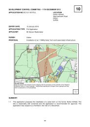
DEVELOPMENT CONTROL COMMITTEE – 11 DECEMBER 2012<br />
APPLICATION NO DC/12/1119/FUL<br />
EXPIRY DATE 6 January 2013<br />
APPLICATION TYPE Full Application<br />
LOCATION<br />
Land Adjacent To Bonners Farm<br />
Mill Road<br />
Wissett<br />
Suffolk<br />
11<br />
APPLICANT<br />
<strong>Chediston</strong> <strong>Hall</strong> 1 Solar Park Limited<br />
PARISH<br />
PROPOSAL<br />
Wissett<br />
Installation of a 12.3MW solar farm and associated infrastructure<br />
DO NOT SCALE<br />
Reproduced from the Ordnance Survey mapping with the permission of the Controller of Her Majesty’s<br />
Stationery Office © Crown Copyright. Unauthorised reproduction infringes Crown copyright and may<br />
lead to prosecution or civil proceedings.<br />
SUMMARY<br />
1.1 The proposal is for a “solar farm”, consisting of 50,376 photovoltaic panels on land to the<br />
west of the village of Wissett, adjoining the district boundary. Landscape impact is likely to<br />
be the main issue, but there are also outstanding issues with archaeology. The application<br />
was the subject of a members site visit on 3 December.<br />
SITE DESCRIPTION<br />
2.1 The site comprises 24.9 hectares of agricultural land to the west of Mill Lane, Wissett. The<br />
site is approximately 1.5 kilometres north west of Halesworth. A public footpath runs along<br />
98
the south western boundary of the site (which also forms the boundary with Suffolk Coastal<br />
district). A further public footpath runs along part of the northern boundary of the site.<br />
2.2 There are two small areas of woodland adjacent to the site, an area known as “The Spring”<br />
which forms part of the north east boundary of the site and a smaller unnamed area adjacent<br />
to the south east boundary.<br />
PROPOSAL<br />
3.1 The proposal is for the installation of a “solar farm” comprising approximately 50,376 solar<br />
panels generating up to 12.3MW of electricity to feed into the electricity grid network. The<br />
application states that this could supply up to 3,041homes with their annual electricity<br />
requirements.<br />
3.2 The application is accompanied by:<br />
• A Planning and Environmental Report<br />
• A Flood Risk Assessment<br />
• A Design and Access Statement.<br />
3.3 The solar panels would be mounted on “tables” with a front height of 0.6 metres and a back<br />
panel height of up to 2.2 metres. The panels would be set in rows 4-5 metres apart. Eight<br />
inverter cabins are proposed at intervals throughout the site. A “point of connection facility”<br />
would be provided at the southern end of the site. 2 metre high security fencing would be<br />
provided with CCTV cameras at intervals of 100 metres, mounted on four metres high pillars.<br />
3.4 Access would be taken from <strong>Chediston</strong> Street – the B1123 – the access point is in fact within<br />
Suffolk Coastal district – with an access road joining existing farm roads close to <strong>Chediston</strong><br />
<strong>Hall</strong>. The total distance between the site and the public highway would be approximately<br />
1300 metres.<br />
CONSULTATIONS/COMMENTS<br />
4.1 Neighbour consultation/representations: two objections have been received, on the<br />
grounds of loss of view, loss of property value and potential damage to boundary trees.<br />
4.2 Wissett Parish <strong>Council</strong> Comments: The parish council met to discus the planning<br />
application for <strong>Chediston</strong> <strong>Hall</strong> solar farm. The decision was to approve the solar farm,<br />
however there were some concerns that councillors felt it was necessary to address. These<br />
are listed below:<br />
• Assurance that the solar panels will not be higher than 2.2 metres as stated in the plans.<br />
Concerns were raised that the panels would be mounted on tables which would be<br />
graduated and therefore higher than that stated.<br />
• Assurance that no other solar farms are planned for this area.<br />
• Request that mature indigenous hedging be planted<br />
• We have been informed that the electricity grid will be at maximum capacity. Will this<br />
affect individual households from installing solar panels?<br />
4.3 <strong>Chediston</strong> Parish <strong>Council</strong> comments awaited<br />
Consultees<br />
4.4 Suffolk Wildlife Trust: We have read the ecology section of the Planning and Environmental<br />
report and note the findings of the ecological consultant. We request that the ecological<br />
recommendations made within the report are implemented in full, via a condition of planning<br />
99
consent, should permission be granted. In addition to the recommendations included within<br />
the Planning and Environmental report we have the following comments:<br />
4.5 Existing woodland and hedges: The site is currently surrounded by hedges and two small<br />
woodlands, we request that all these features are retained and that they are suitably buffered<br />
from the solar panels and any associated development. The wildlife value of hedges is<br />
largely dependent on their subsequent management and this in turn will depend on sufficient<br />
room being allowed for hedges to fill out and have a graded tall herb edge. If hedges need to<br />
be close clipped with short grass to the base their value will be largely visual rather than to<br />
the benefit of wildlife. We therefore recommend that sufficient gaps are left between the<br />
edges of the panel rows and the hedges. Management of these gaps should allow a graded,<br />
tall herb edge to develop up to the hedge.<br />
4.6 Enhancements: Developments such as solar farms offer opportunities to provide ecological<br />
enhancements on the site. We would support the planting of new native hedges and the<br />
‘gapping up’ of the existing hedgerows where this is necessary. In addition to the proposed<br />
hedges we would also suggest that opportunities to establish additional areas of scrub are<br />
explored. This would provide additional habitat for bird species such as turtle dove. As the<br />
current outbreak of ash die back (Chalara fraxinea) highlights it is important that only locally<br />
grown plants from seed of local provenance are used in planting schemes.<br />
4.7 It is also understood that this site and the surrounding land are in various environmental<br />
stewardship schemes (Natural England Nature on the Map website). We would suggest that<br />
further ecological enhancements at this site could be guided by the types of habitats already<br />
being targeted through these schemes.<br />
4.8 Management: We would recommend that, should permission be granted, a management<br />
plan for the site is produced prior to the commencement of any works and that its<br />
implementation is secured by condition. We would recommend that this management plan<br />
includes the strip of land to the south west of the proposed solar farm, outside of the<br />
proposed security fence but within the red line boundary shown on the proposed site layout<br />
plan drawing.<br />
4.9 Suffolk County - Archaeological Unit This application concerns the installation of a solar<br />
farm. The site of the proposed development has high potential for the discovery of important<br />
hitherto unknown heritage assets of archaeological interest in view of its large size and<br />
location close to a number of sites recorded in the County Historic Environment Record. This<br />
includes a number of multi-period findspots (CHD 050, CHD 069, WSS 007). However, the<br />
site has not been the subject of previous systematic investigation.<br />
4.10 Given the potential, lack of previous investigation and large size of the proposed<br />
development area, I recommend that, in order to establish the full archaeological implications<br />
of this area and the suitability of the site for the development, the applicant should be<br />
required, prior to determination of the application, to provide an archaeological evaluation of<br />
the site. The proposed development area cannot be assessed or approved in our view until a<br />
full archaeological evaluation has been undertaken, and the results of this work will enable<br />
us to accurately quantify the archaeological resource (both in quality and extent). This is in<br />
accordance with paragraphs 128 and 129 of the National Planning Policy Framework.<br />
4.11 Decisions on the suitability of the site, and also the need for, and scope of, any further work<br />
should there be any below-ground archaeological finds of significance, will be based upon<br />
the results of the evaluation.<br />
4.12 A geophysical survey should be undertaken in the first instance. The results of this work<br />
would then inform the archaeological mitigation strategy for the development area, which is<br />
likely to involve trial trenching and/or monitoring of any groundworks. The results of the<br />
evaluation must be presented in the application, along with a detailed strategy for further<br />
investigation. The results should inform the development to ensure preservation in situ of any<br />
100
previously unknown nationally important archaeological remains within the development<br />
area.<br />
4.13 Suffolk Preservation Society I am writing on behalf of the Suffolk Preservation Society with<br />
regard to the above application.<br />
4.14 This application highlights the need for county-wide guidance to assist decision-making in<br />
order to prevent land subject to competing uses for dwellings, agriculture, tourism, and<br />
recreation being inappropriately diverted to what is, in essence, an industrial use, thereby<br />
leading to the unnecessary blighting of the Suffolk landscape. As noted by Natural England,<br />
‘Careful site selection and design is the best way to avoid or minimize potential adverse<br />
landscape and visual impacts’. (‘Solar Parks: maximizing environmental benefits’, TIN101,<br />
p.4, italics added.)<br />
4.15 The location for this proposed solar park is a gently rolling landscape of ancient fields,<br />
hedges, copses, footpaths, and small villages. The site falls into two categories that Natural<br />
England has designated as reducing the chance that solar parks can be accommodated in<br />
the landscape – the presence of small scale historic settlement, roads and tracks; and<br />
physically or perceptually remote, peaceful or tranquil. (TIN101, p. 6, Table 1.)<br />
4.16 The proposed installation is considerably more dominant than anticipated by TIN101’s<br />
guidance. It is almost 25 hectares vs 2-15 hectares. Its solar panels will stand 4.4 metres<br />
from the ground when the total height of the panels and supporting tables are calculated, as<br />
opposed to the 1.5 - 2.5 metres contemplated by Natural England. To appreciate impact, one<br />
needs also take account of the collective industrial infra-structure – panels, access tracks,<br />
fencing (described as ‘deer’ but perhaps more likely to be industrial style weld mesh for<br />
security reasons), cameras, housing for transformer and metering stations.<br />
4.17 The grade of agricultural land requires clarification – is it 3A or 3B? If the former, then it<br />
would be considered ‘best and most versatile agricultural land’, which is discouraged from<br />
being taken out of agriculture production for sustained periods – in this case 25 years.<br />
(TIN101, p. 2, citing TIN049.)<br />
4.18 Suffolk has ample brown field sites, including former airbases, which would be optimal for<br />
siting solar farms, not to mention industrial roof space. There is no evidence in the<br />
applicant’s proposal of a sequential approach to site selection.<br />
4.19 NPPF, P. 98, confirms that, although solar park proposals should not be required to prove<br />
the benefits of sustainable energy, approval is contingent upon the impact of such proposals<br />
being acceptable or capable of being made acceptable.<br />
4.20 The principles for evaluating this application are contained in the <strong>Waveney</strong> Landscape<br />
Character guidelines and the <strong>Council</strong>’s policies CS02 and CS16 which seek to preserve and<br />
enhance local landscape character and biodiversity.<br />
4.21 Landscape Character The field lies within the Landscape Type I1 Saints Plateau West<br />
Farmed Plateau Clayland; the relevant objectives for this landscape are set out in Para I121<br />
and I122 (italics added):<br />
4.22 I1.21 The primary strategic objective for this character area is to conserve and enhance the<br />
small scale historic landscape pattern which persists at points and to conserve the low key,<br />
well wooded settlements, maintaining the tranquil, rural and remote character of the area.<br />
4.23 Landscape Management: ‘I1.22 Principal landscape management objectives are to reinforce<br />
existing native hedgerows with appropriate species in order to enhance landscape structure<br />
and opportunities for connectivity. New native hedgerow tree planting should also be<br />
considered as part of the long term approach to hedgerow management and enhancement.<br />
Conserve and enhance the remaining examples of co axial field boundaries.’<br />
101
4.24 Core Strategy Policies Policy CS02 High Quality and Sustainable Design. ‘All development<br />
proposals must demonstrate a high quality and sustainable design that positively improves<br />
the character, appearance and environmental quality of an area’.<br />
4.25 ‘Proposals for development are expected to retain and add to local distinctiveness, retain<br />
tranquility, avoid fragmentation of habitats and seek to enhance wildlife corridors and<br />
networks. In addition, proposals should conserve and contribute towards the enhancement of<br />
the landscape character, biodiversity and geodiversity of the <strong>District</strong>…’<br />
4.26 CS 16 Natural Environment: “The <strong>District</strong> <strong>Council</strong> will work with partners such as the Suffolk<br />
Wildlife Trust, Suffolk Biodiversity Partnership, Suffolk Coast and Heaths Project, the Broads<br />
Authority and the community to protect and enhance the natural and historic environment in<br />
the <strong>District</strong>. Proposals for development are expected to retain and add to local<br />
distinctiveness, retain tranquility, avoid fragmentation of habitats and seek to enhance wildlife<br />
corridors and networks.’<br />
4.27 Applying the above principles to the application, we note a lack of rigour in assessing the<br />
proposal’s impacts on landscape character and quality of the field and location. We have not<br />
been able to locate a summary of the LVIA (Landscape and visual impact assessment)<br />
carried out. Whilst we recognize that this is not EIA development, a summary would be<br />
helpful in identifying the level of impacts on the quality and views of this arable landscape.<br />
4.28 The submitted Planning and Environmental Statement (Para 5.89) does refer to the<br />
landscape impact as being detrimental with the scheme introducing an artificial element into<br />
the landscape. ‘Overall, this will result in a moderate adverse effect on the landscape<br />
character of the local context with effects diminishing further over time as a result of the<br />
growth of new boundary hedgerow planting…’<br />
4.29 The Design and Access Statement (Paragraphs 4.17 and 4.18) clarifies that Solarcentury is<br />
relying on the new hedging to align the solar park with planning principles. The proposed<br />
new hedging will ‘effectively hide the development from view. This includes new hedgerow to<br />
be planted along the south western and north eastern boundaries to obscure the site from<br />
the public rights of way that adjoin the site, coupled with hedgerow reinforcement on the<br />
eastern boundaries’.<br />
4.30 However, achieving mitigation depends on the height, depth and bulk of hedging. The new<br />
hedging relied on to screen the solar panels from neighbouring footpaths and property could<br />
take, at minimum, half the lifetime of the panels to reach young maturity.<br />
4.31 In addition, without prejudice to our position on the choice of site, we provide the following<br />
comments on the proposed hedging.<br />
• The hedge species mix contains no tree species despite the recommendations of the<br />
Ecologist report (Avian Ecology Para 6.69). We assume this is due to shading concerns.<br />
• Some species (guilder rose and midland thorn) are unlikely to grow naturally at this<br />
location. All hedgerow schemes should use the Parish hedgerow survey as a reference<br />
point for ensuring that suitable species mixes are chosen, which was not done here.<br />
• If mature ash trees currently provide any screening, these may succumb to die back. The<br />
Landscape Institute recent guidelines on assessing impact in this event should be noted<br />
and taken into account.<br />
• It is disappointing that no additional hedges are proposed to break up the scale of the<br />
proposal and provide internal buffer spaces.<br />
• In terms of buffer zones the submitted aerial photograph shows wide field margins that<br />
perhaps are part of a farm stewardship scheme. However the current application is for<br />
panels to be sited within 4/5 metres of the hedgerows seemingly reducing these wider<br />
margins. Scope for wider buffer zones, with fences kept further from perimeter<br />
102
hedgerows, are advisable to ensure protection of hedgerows and trees and minimizing<br />
their shading impacts.<br />
4.32 In sum, an objection on grounds of impact and unsuitable large proposal in high quality<br />
landscape. Given that solar energy is universally available, and the County’s topography is<br />
slight, it cannot be demonstrated that solar PV at <strong>Chediston</strong> presents any public benefit<br />
beyond that of other sites. The applicant has thus failed to demonstrate that alternative sites<br />
would not be sequentially preferable or that the conflict with <strong>Waveney</strong> Core Strategies is<br />
justified or necessary.<br />
4.33 County Planning Officer was consulted on the 19 October 2012.<br />
4.34 Natural England: From the information provided with this application, it does not appear to<br />
fall within the scope of the consultations that Natural England would routinely comment on.<br />
The lack of specific comment from Natural England should not be interpreted as a statement<br />
that there are no impacts on the natural environment, but only that the application is not likely<br />
to result in significant impacts on statutory designated sites, landscapes or species. It is for<br />
the local authority to determine whether or not this application is consistent with national or<br />
local policies on biodiversity and landscape and other bodies and individuals may be able to<br />
help the Local Planning Authority (LPA) to fully take account of the environmental value of<br />
this site in the decision making process, LPAs should seek the views of their own ecologists<br />
when determining the environmental impacts of this development.<br />
4.35 We would, in any event, expect the LPA to assess and consider the possible impacts<br />
resulting from this proposal on the following issues when determining this application:<br />
4.36 Protected species: If the LPA is aware of, or representations from other parties highlight the<br />
possible presence of a protected or Biodiversity Action Plan (BAP) species on the site, the<br />
authority should request survey information from the applicant before determining the<br />
application. The Government has provided advice1 on BAP and protected species and their<br />
consideration in the planning system.<br />
4.37 Natural England Standing Advice is available on our website to help local planning<br />
authorities better understand the impact of this particular development on protected or BAP<br />
species should they be identified as an issue at particular developments. This also sets out<br />
when, following receipt of survey information, the authority should undertake further<br />
consultation with Natural England.<br />
4.38 Local wildlife sites: If the proposal site could result in an impact on a Local Site, Local Nature<br />
Reserve (LNR) or priority habitat the authority should ensure it has sufficient information to<br />
fully understand the impact of the proposal on the local site before it determines the<br />
application, ensuring that it does so in conformity with the wording of paragraph 168 of the<br />
National Planning Policy Framework. For further information on Local Sites, your authority<br />
should seek views from your ecologist, or the Local Sites designation body in your area.<br />
4.39 Biodiversity enhancements: This application may provide opportunities to incorporate<br />
features into the design which are beneficial to wildlife, such as the incorporation of roosting<br />
opportunities for bats or the installation of bird nest boxes. The authority should consider<br />
securing measures to enhance the biodiversity of the site from the applicant, if it is minded to<br />
grant permission for this application. This is in accordance with Paragraph 118 of the NPPF.<br />
Additionally, we would draw your attention to Section 40 of the Natural Environment and<br />
Rural Communities Act (2006) which states that ‘Every public authority must, in exercising its<br />
functions, have regard, so far as is consistent with the proper exercise of those functions, to<br />
the purpose of conserving biodiversity’. Section 40(3) of the same Act also states that<br />
‘conserving biodiversity includes, in relation to a living organism or type of habitat, restoring<br />
or enhancing a population or habitat’.<br />
103
4.40 Local Landscape: This proposal does not appear to be either located within, or within the<br />
setting of, any nationally designated landscape. All proposals however should complement<br />
and where possible enhance local distinctiveness and be guided by your Authority’s<br />
landscape character assessment where available, and the policies protecting landscape<br />
character in your local plan or development framework.<br />
4.41 Should the proposal be amended in a way which significantly affects its impact on the natural<br />
environment then, in accordance with Section 4 of the Natural Environment and Rural<br />
Communities Act 2006, Natural England should be consulted again.<br />
4.42 Suffolk County - Highways Department: recommends that any permission should include<br />
a condition requiring a HGV Deliveries Management Plan.<br />
4.43 The Ramblers Association The Ramblers Association, currently, have no policies with<br />
regard to solar farms providing the Rights of Way remain open and are restored to their<br />
original condition. Please note Footpaths 3 and 5 (Wissett) are close to this development.<br />
4.44 Suffolk County - Rights Of Way Thank you for your consultation dated 19 October 2012<br />
concerning the above application. Public Footpath No. 5 is adjacent to the development site,<br />
and Public Footpath No. 3 provides access to it.<br />
4.45 The Public Rights of Way do not appear to be directly affected by this application and we<br />
have no objection to the proposed works, but would make the following points in respect of<br />
public rights of way:<br />
1. There must be no interference with the surface of the right of way as a result of the<br />
development.<br />
2. The right of way must be kept clear and unobstructed for users and no structures placed<br />
upon the right of way.<br />
3. Any damage to the surface of the route as a result of the development must be made<br />
good by the applicant.<br />
4. The Highways Authority is not responsible for maintenance and repair of the route beyond<br />
the wear and tear of normal use for its status and it will seek to recover the costs of any<br />
such damage that it has to remedy.<br />
There are four different statuses of public rights of way:<br />
• Public footpath – this should only be used by people on foot, or using a mobility<br />
vehicle.<br />
• Public bridleway – in addition to people on foot, bridleways may also be used by<br />
someone on a horse or someone riding a bicycle.<br />
• Restricted byway – this has similar status to a bridleway, but can also be used by a<br />
‘non- motorised vehicle’, for example a horse and carriage.<br />
• Byway open to all traffic (BOAT) – these can be used by all vehicles, including<br />
motorised vehicles as well as people on foot, on horse or on a bicycle.<br />
5. The Area Rights of Way Office must approve any proposed works to the surface of the<br />
routes.<br />
6. The applicant should have private rights to take motorised vehicles over the public right of<br />
way. Without lawful authority it is an offence under the Road Traffic Act 1988 to take a<br />
motorised vehicle over a public right of way other than a byway. We do not keep records<br />
of private rights.<br />
7. If the public right of way is temporarily affected by works which will require it to be closed,<br />
a Traffic Regulation Order will need to be sought from the County <strong>Council</strong>. A fee is<br />
payable for this service.<br />
8. There may be other public rights of way that exist over this land that have not been<br />
registered on the Definitive Map. These paths are either historical paths that were never<br />
claimed under the National Parks and Access to the Countryside Act 1949, or paths that<br />
have been created by public use giving the presumption of dedication by the land owner<br />
whether under the Highways Act 1980 or by Common Law. This office is not aware of any<br />
such claims.<br />
104
9. Public rights of way are protected by law. If you wish to build upon, block, divert or<br />
extinguish a right of way within the development area marked on the planning application<br />
an order must be made, confirmed and brought into effect by the local planning authority,<br />
using powers under s257 of the Town and Country Planning Act 1990.<br />
4.46 Suffolk Coastal <strong>District</strong> <strong>Council</strong> was consulted on the 25 October 2012.<br />
PUBLICITY<br />
4.47 The application has been the subject of the following press advertisement:<br />
Category Published Expiry Publication<br />
Major Application, 19.10.2012 08.11.2012 Beccles and Bungay<br />
Public Right of Way<br />
Affected,<br />
Journal<br />
Major Application,<br />
Public Right of Way<br />
Affected,<br />
19.10.2012 08.11.2012 Lowestoft Journal<br />
SITE NOTICES<br />
4.48 The following site notices have been displayed:<br />
WDC General Site Notice<br />
Reason for site notice: Major Application, In the Vicinity of<br />
Public Right of Way, Date posted 01.11.2012 Expiry date<br />
21.11.2012<br />
PLANNING POLICY<br />
5.1 The <strong>Waveney</strong> Core Strategy was adopted in January 2009. Policy CS02 requires high<br />
quality and sustainable design. Policy CS16 commits the <strong>Council</strong> to protect and enhance the<br />
natural and historic environment of the <strong>District</strong>.<br />
5.2 The Development Management policies were adopted in January 2011. Policy DM03<br />
deals with renewable energy and so is the most relevant policy for the determination of this<br />
application. It is considered in detail in the following section of this report.<br />
5.3 Policy DM02 sets design principles for new development. Policy DM27 deals with the<br />
protection of landscape character.<br />
5.4 The National Planning Policy Framework is also relevant to the application and is referred<br />
to below.<br />
PLANNING CONSIDERATIONS<br />
6.1 The starting point for the consideration of this application is planning policy, both National<br />
and Local.<br />
6.2 The National Planning Policy Framework sets out an approach that is proactive towards<br />
renewable energy developments. Paragraph 98 states that applications should be approved<br />
if impacts are, or can be, made acceptable unless material considerations indicate<br />
otherwise.<br />
6.3 Development Management policy DM03 states that:<br />
“Proposals for stand alone energy generation and other CO2 reductions will generally be<br />
supported. The <strong>District</strong> is seeking new renewable energy generation capacity to deliver an<br />
105
appropriate contribution towards the UK Government's binding renewable energy target.<br />
Therefore targets for <strong>Waveney</strong> <strong>District</strong> include:<br />
• Approximately 30% electricity from renewable sources by 2021<br />
• Approximately 12% heat from renewable sources by 2021.<br />
Renewable energy schemes will be permitted where:<br />
• There are no significant adverse effects or cumulative adverse effects upon the<br />
landscape, townscape and historic features;<br />
• There are no significant adverse effects on the amenities of nearby residents by way of<br />
noise, dust, odour or increases in traffic; and<br />
• The wider environmental, economic, social and community benefits directly related to<br />
the scheme outweigh any potentially significant adverse effects.<br />
In areas of national importance, large-scale renewable energy infrastructure will not be<br />
permitted unless it can be demonstrated that the objectives of the designation are not<br />
compromised. Small-scale developments will be permitted where they are sympathetically<br />
designed and located, include any necessary mitigation measures and meet the criteria<br />
above.<br />
When the permitted technology is no longer operational there is a requirement to<br />
decommission, remove the facility and complete a restoration of the site to its original<br />
condition.”<br />
6.4 In is clear that the proposal will contribute towards meeting the <strong>District</strong>’s energy targets set<br />
out in policy DM03 with the energy generated being transferred directly into the national grid.<br />
The renewable energy proposal is consistent with the <strong>District</strong> overall aim of improving<br />
sustainability and contributing towards Suffolk becoming the ‘Greenest County’. Policy DM03<br />
supports renewable energy installations where they are proposed in appropriate locations<br />
where they will not have significant adverse impacts on the amenity of local people, historic<br />
features or on the environment. The wider economic, social and environmental benefits of<br />
the proposal should be considered against any significant impacts of the surrounding area.<br />
6.5 In terms of impact of the development, the main potential impacts to be considered are<br />
therefore:<br />
• Landscape and visual impact<br />
• Impact on wildlife and ecology<br />
• Impact on built heritage and archaeology and<br />
• Construction impacts, principally traffic.<br />
6.6 In terms of landscape impact, the NPPF also places strong emphasis on the protection of<br />
the environment, particularly landscapes that are protected. The area of land to be covered<br />
by the solar PV array is significant. However the structural form of the solar PV array is low<br />
level. In addition an appropriate screening scheme could be implemented to minimise impact<br />
on the character of the area when observed from ground level.<br />
6.7 There are hedges around part of the site, as well as the small areas of woodland noted<br />
above, but the eastern side is generally more open. The gently rolling landform will also<br />
provide visibility of the site from some locations.<br />
6.8 The site is not in a designated landscape. However part of it does fall within the “Blyth<br />
Tributary Valley Farmland” Landscape Character Assessment Area. Policy DM27 states<br />
that:<br />
“Development affecting the…Tributary Valley Farmland areas will not be permitted unless it<br />
can be demonstrated there is an overriding national need for development and no alternative<br />
site can be found.”<br />
106
6.9 The development is likely to have a life of around 25 years, and when decommissioned there<br />
should be no lasting effects on the landscape. In addition the opportunities for additional<br />
screening to reinforce the existing hedges and the limited overall height of the panels with<br />
also reduce the landscape impact.<br />
6.10 Nevertheless the objection from the Suffolk Preservation Society (paragraphs 4.13 to 4.32<br />
above) has some merit.<br />
6.11 The Design and Access Statement proposes new hedgerow planting along the south<br />
western and north eastern boundaries, and reinforcing the hedgerows on the eastern<br />
boundary.<br />
6.12 The <strong>Council</strong>’s Landscape Adviser recommends conditions requiring this new hedgerow<br />
planting, with species to be agreed.<br />
6.13 The agricultural land that makes up the site is classified as Grade 3, indicating that the site is<br />
of moderate quality but is not high quality for crop growing.<br />
6.14 Suffolk Wildlife Trust has provided recommendations to enhance the biodiversity of the site,<br />
which could be secured by a planning condition.<br />
6.15 In respect of built heritage and archaeology, there are no listed buildings sufficiently close to<br />
the site to be affected, the nearest being “Millcroft”, approximately 400 metres from the site<br />
boundary and “Whitehouse Farm”, approximately 330 metres from the site boundary; both<br />
are on Mill Lane. However Suffolk Archaeology considers that an archaeological evaluation<br />
of the site is required before the application is determined. Decisions on the suitability of the<br />
site, and also the need for, and scope of, any further work should there be any below-ground<br />
archaeological finds of significance, would then be based upon the results of the evaluation.<br />
This work had not been commenced as this report was written.<br />
6.16 Construction impacts are primarily traffic. The Design and Access Statement indicates that<br />
the construction of the solar farm would require 192 HGV trips to the site (so 384<br />
movements in total), with 18 movements per day. The County <strong>Council</strong> has recommended a<br />
condition requiring a HGV Deliveries Management Plan.<br />
CONCLUSION<br />
7.1 There is no doubt that this will be a significant development. Landscape impact is likely to be<br />
the most critical issue, but bearing in mind the low-level nature of the development, the<br />
existing landscape and topography, and the potential for mitigation is it not considered that<br />
this will be so significant as to outweigh the benefit of the renewal energy that will be<br />
provided.<br />
7.2 However at the time of writing this report archaeology remains an outstanding issue.<br />
RECOMMENDATION<br />
A verbal recommendation will be made depending on the position with archaeology at the time of<br />
the Committee meeting.<br />
If the pre-determination archaeological investigation has not been completed, then the application<br />
will be recommended for refusal on the grounds of potential impact on archaeology.<br />
Similarly, if the investigation reveals that the development will affect significant archaeological<br />
remains the application will be recommended for refusal.<br />
However should the pre-determination investigation be completed prior to the meeting, and<br />
confirms that that is no reason why permission should not be granted (with conditions if necessary)<br />
then the application will be recommended for approval subject to the following conditions:<br />
107
1. The development hereby permitted shall be begun within a period of three years beginning<br />
with the date of this permission.<br />
Reason: In accordance with Section 91 of the Town and Country Planning Act 1990 as<br />
amended.<br />
2. The development hereby permitted shall not be brought into use until it has been completed<br />
in all respects strictly in accordance with drawing reference SAVIL-CHEDI-001-100, SAVIL-<br />
CHEDI-001-120 rev B, SAVIL-MULTI-001-201, SAVIL-MULTI-001-210, SAVIL-MULTI-001-<br />
211, SAVIL-MULTI-001-212, SAVIL-MULTI-001-213, SAVIL-MULTI-001-214, SAVIL-MULTI-<br />
001-216, SAVIL-MULTI-222 and BPI-368398-2001 rev C received 8 October 2012, for which<br />
permission is hereby granted or which are subsequently submitted to and approved in<br />
writing by the Local Planning Authority and in compliance with any conditions imposed by<br />
the Local Planning Authority.<br />
Reason: To secure a properly planned development.<br />
3. The planning permission is for a period from the date of this permission until the date<br />
occurring 25 years after the date of commissioning of the development. Written confirmation<br />
of the date of commissioning of the development shall be provided to the Local Planning<br />
Authority no later than 1 calendar month after that event.<br />
(“Commissioning” is defined as the point at which the solar farm is put into active service or<br />
becomes “active”, or is in use or useable condition)<br />
Reason: To ensure that the landscape impact of the development exists only for the lifetime<br />
of the development.<br />
4. If the solar farm hereby permitted ceases to operate for a continuous period of 6 months<br />
then, unless otherwise agreed in writing by the Local Planning Authority, a scheme for the<br />
decommissioning and removal of the panels and any other ancillary equipment, shall be<br />
submitted to and agreed in writing by the Planning Authority within 3 months of the end of<br />
the cessation period. The scheme shall include details for the restoration of the site. The<br />
scheme shall be implemented within 12 months of the date of its agreement by the Local<br />
Planning Authority.<br />
Reason: To ensure that the landscape impact of the development exists only for the lifetime<br />
of the development.<br />
5. In relation to the construction of the development hereby permitted; no machinery shall be<br />
operated, no process shall be carried out and no construction traffic shall enter or leave the<br />
site between the hours of 08.00 hours and 18.00 hours Monday to Friday, nor between the<br />
hours of 8.00 hours and 13.00 hours on Saturdays, nor at any time on Sundays or Bank<br />
Holidays unless approved in writing in advance with the Local Planning Authority.<br />
Reason: In the interests of the amenity of the area<br />
6. All HGV traffic movements to and from the site over the duration of the construction period<br />
shall be subject to a Deliveries Management Plan which shall be submitted to the planning<br />
authority for approval a minimum of 28 days before any deliveries of materials commence.<br />
No HGV movements shall be permitted to and from the site other than in accordance with<br />
the routes defined in the Plan. The site operator shall maintain a register of complaints and<br />
record of actions taken to deal with such complaints at the site office as specified in the Plan<br />
throughout the period of occupation of the site.<br />
Reason: To reduce and / or remove as far as is reasonably possible the effects of HGV<br />
traffic in sensitive areas.<br />
108
7. Before any development is commenced details of measures to enhance the biodiversity of<br />
the site shall be submitted to and approved by the local planning authority. The approved<br />
scheme shall be implemented within 12 months of the commencement of development.<br />
Reason: to preserve and enhance the biodiversity of the site.<br />
8. In accordance with advice set out in British Standard BS5837:2012 Trees in relation to<br />
design, demolition and construction - Recommendations. No development shall take place<br />
until full details of both hard and soft landscape works have been submitted to and approved<br />
in writing by the Local Planning Authority and these works shall be carried out as approved.<br />
These details shall include proposed finished levels or contours; means of enclosure; hard<br />
surfacing materials; proposed and existing functional services above and below ground (e.g.<br />
drainage power, communications cables, pipelines etc indicating lines, manholes, supports<br />
etc); retained historic landscape features and proposals for restoration, where relevant. Soft<br />
landscape works shall include planting plans; written specifications (including cultivation and<br />
other operations associated with plant and grass establishment); schedules of plants, noting<br />
species, plant sizes and proposed number/densities where appropriate; implementation<br />
programme.<br />
Reason: To ensure the provision of amenity afforded by appropriate landscape design.<br />
9. In accordance with advice set out in British Standard BS5837:2012 Trees in relation to<br />
design, demolition and construction - Recommendations. The landscaping scheme shall be<br />
completed within six months from the date when the solar farm is brought into use, or such<br />
other date as may be agreed in writing with the Local Planning Authority. Any trees or plants<br />
which die during the first 5 years shall be replaced during the next planting season.<br />
Reason: To ensure the provision of amenity afforded by appropriate landscape design.<br />
10. Notwithstanding the submitted details, security lighting shall be infra red only.<br />
Reason: to avoid interference with bats and other nocturnal animals.<br />
BACKGROUND PAPERS<br />
CONTACT<br />
Case File DC/12/1113/FUL. Contact Development<br />
Management, The Marina Centre, Lowestoft.<br />
Richard Amor tel. 01502 523018 or<br />
richard.amor@waveney.gov.uk<br />
109