Download this article (PDF) - Inside GNSS
Download this article (PDF) - Inside GNSS
Download this article (PDF) - Inside GNSS

Create successful ePaper yourself
Turn your PDF publications into a flip-book with our unique Google optimized e-Paper software.
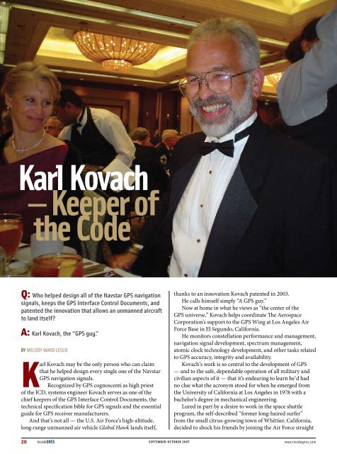
Karl Kovach<br />
— Keeper of<br />
the Code<br />
Q: Who helped design all of the Navstar GPS navigation<br />
signals, keeps the GPS Interface Control Documents, and<br />
patented the innovation that allows an unmanned aircraft<br />
to land itself?<br />
A: Karl Kovach, the “GPS guy.”<br />
by Melody Ward Leslie<br />
Karl Kovach may be the only person who can claim<br />
that he helped design every single one of the Navstar<br />
GPS navigation signals.<br />
Recognized by GPS cognoscenti as high priest<br />
of the ICD, systems engineer Kovach serves as one of the<br />
chief keepers of the GPS Interface Control Documents, the<br />
technical specification bible for GPS signals and the essential<br />
guide for GPS receiver manufacturers.<br />
And that’s not all — the U.S. Air Force’s high-altitude,<br />
long-range unmanned air vehicle Global Hawk lands itself,<br />
thanks to an innovation Kovach patented in 2003.<br />
He calls himself simply “A GPS guy.”<br />
Now at home in what he views as “the center of the<br />
GPS universe,” Kovach helps coordinate The Aerospace<br />
Corporation’s support to the GPS Wing at Los Angeles Air<br />
Force Base in El Segundo, California.<br />
He monitors constellation performance and management,<br />
navigation signal development, spectrum management,<br />
atomic clock technology development, and other tasks related<br />
to GPS accuracy, integrity and availability.<br />
Kovach’s work is so central to the development of GPS<br />
— and to the safe, dependable operation of all military and<br />
civilian aspects of it — that it’s endearing to learn he’d had<br />
no clue what the acronym stood for when he emerged from<br />
the University of California at Los Angeles in 1978 with a<br />
bachelor’s degree in mechanical engineering.<br />
Lured in part by a desire to work in the space shuttle<br />
program, the self-described “former long-haired surfer”<br />
from the small citrus-growing town of Whittier, California,<br />
decided to shock his friends by joining the Air Force straight<br />
20 <strong>Inside</strong><strong>GNSS</strong> september/october 2007 www.insidegnss.com
HUMAN<br />
Engineering<br />
out of UCLA. But instead of<br />
going to the space shuttle, the<br />
newly minted 2nd Lt. Kovach<br />
was assigned to the Navstar GPS<br />
Joint Program Office (JPO),<br />
where he helped put together<br />
the specifications for production<br />
prototype user equipment<br />
contracts.<br />
“There were tons of obstacles,<br />
from figuring out what a GPS<br />
receiver actually needs to do,<br />
to getting a minimum set of<br />
configurations defined to satisfy the peculiar needs of all<br />
those military user platforms: aircraft, ships, tanks, and<br />
handhelds,” he says.<br />
But the most daunting obstacle was that so many people<br />
simply didn’t believe in GPS in the late 1970s.<br />
Kovach remembers that the biggest opportunities<br />
came from NATO and other military customers, and from<br />
exploiting the incredible growth in digital processing<br />
circuitry. “The strategy was a lot of hard work by a lot of<br />
talented folks, and not giving up when GPS kept getting<br />
canceled,” he says.<br />
Make Way for GPS<br />
In 1980, the first user equipment contracts were awarded.<br />
It was not a small accomplishment. Kovach remembers<br />
carrying an X-set in 1979, when it was the top-of-the-line<br />
GPS receiver. It weighted about 60 pounds —not including<br />
the computer, which doubled the weight— and had to be<br />
cooled with dry ice for flight tests. “Now you can get more<br />
powerful GPS capability in a watch,” he said.<br />
In 1979, the top of the line GPS<br />
receiver package weighted 120<br />
pounds and had to be cooled with<br />
dry ice for flight test. Now you get<br />
more GPS capability in a watch.<br />
Since then Kovach’s career has rocketed along almost<br />
at the same breakneck speed as the absorption of GPS<br />
technology into industry and society at large.<br />
He capped eight years’ active duty as commander of<br />
the GPS Control Segment at California’s Vandenberg Air<br />
Force Base. In that position, he directed the Initial Control<br />
System operations, managed the deployment of the current<br />
Operational Control System (OCS), and guided the transition<br />
of the OCS to Colorado’s Schriever Air Force Base.<br />
In 1986, Kovach moved to ARINC. Founded in 1929<br />
as Aeronautical Radio, the private company is now owned<br />
COMPASS POINTS<br />
Nickname:<br />
K 2 or “K Squared”<br />
Engineering specialty<br />
GPS system engineering.<br />
Favorite Equation<br />
“M = T + E” where “M” is the measurement, “T” is the truth, and “E” is<br />
the error. (“One of the hardest problems engineers face is in getting<br />
the algebraic sign right – <strong>this</strong> equation is a good one for that. I like that<br />
the “M = T + E” equation works for the terms in the broadcast navigation<br />
messages from the on-orbit Navstar satellites.”)<br />
“If I could get away with it, I’d say “t = $” where “t” is time and “$” is<br />
money.”<br />
First heard about GPS<br />
He showed up at Los Angeles Air Force Station in 1978 and was assigned<br />
to the Navstar GPS JPO. “They told me GPS stood for something like<br />
‘General Purpose Satellite’ (they weren’t too sure), and that I had better<br />
get myself on over there to sign in.”<br />
<strong>GNSS</strong> mentor<br />
Lieutenant Colonel Mel Birnbaum, Navstar GPS chief engineer 1979<br />
— 1981.<br />
“My first real boss and one helluva engineer.”<br />
Influences of engineering on his daily non-work life<br />
“I guess I think like an engineer. It just seems natural to use technology<br />
to make my life easier/better. I’m not much of a ‘gadget freak’ though<br />
— except when it comes to cool toys for my daughter. “<br />
His Compass Points<br />
Number One. “My daughter Karlie helps me to remember the world is a<br />
wonder-full place with lots of fun to be had.”<br />
<strong>GNSS</strong>. “Friends and colleagues remind me I’m a small cog in a big<br />
machine and that it takes a lot of cogs pushing together to make<br />
progress.”<br />
Memories of my parents. “My father passed away several years ago,<br />
and the older I get, the wiser I realize he was.”<br />
Knew <strong>GNSS</strong> Had Arrived When . . .<br />
. . . soldiers in the field during the first Gulf War asked their families<br />
back in the States to buy and send them civil GPS receivers to use.<br />
Popular Notion About <strong>GNSS</strong> That Most Annoys<br />
“My pet peeve is on dropping the proper name ‘Navstar,’ because<br />
Navstar is the name of the best global positioning system in the world.”<br />
What’s Next?<br />
“The whole connectivity thing (information everywhere at all times)<br />
and new human-machine interfaces to exploit it. <strong>GNSS</strong> is just the spatial<br />
and temporal underlayment for the information superhighway.”<br />
www.insidegnss.com september/october 2007 <strong>Inside</strong><strong>GNSS</strong> 21
HUMAN ENGINEERING<br />
Back in 1983, Karl meets a Navy F-4, call<br />
sign “Bloodhound 93,” and does his best<br />
“Top Gun” impersonation.<br />
by the major U.S. airlines and provides transportation<br />
communications and systems engineering for airports,<br />
aviation, the U.S. military, and the federal government.<br />
There Kovach served as senior principal engineer, then<br />
technical director, and finally as a fellow in the company’s<br />
Space Systems GPS program.<br />
In 2007, he left ARINC for Aerospace Corporation, a<br />
federally funded research and development center for the<br />
U.S. Department of Defense. Aerospace had conducted<br />
the early studies on GPS during the 1960s that laid the<br />
foundation for the current system.<br />
In 2003, the same year as his Global Hawk UAV patent,<br />
the U.S. Institute of Navigation honored Kovach with the<br />
Weems Award, given to one person each year for extensive<br />
and continuous contributions” to the development,<br />
operation, and use of GPS. That honor crowned a string<br />
of awards beginning with a 1982 “Special People Award”<br />
from the Air Force Association up through ARINC’s first<br />
Chairman’s Award given to Kovach in 2000.<br />
A Full Portfolio<br />
Industry insiders agree that Kovach’s multiple achievements,<br />
including authoring or coauthoring some 80 technical papers<br />
(25 of which are classified), put him head and shoulders<br />
above the crowd.<br />
U.S. Air Force Colonel Mark Crews, chief engineer of the<br />
GPS Wing, listed Kovach’s “monumental” contributions to<br />
GPS in an email to <strong>Inside</strong> <strong>GNSS</strong>:<br />
• Developed the original GPS signal interface specification.<br />
• Authored the first Precise Positioning<br />
Service Performance Standard (PPS<br />
PS).<br />
• Led the Defense Department’s PPS<br />
receiver certification effort for safetyof-flight<br />
operations in civil-controlled<br />
airspace.<br />
• Performed the first comprehensive<br />
integrity failure mode and effects<br />
analysis (IFMEA) for GPS.<br />
• Conceived and developed the Notice<br />
Advisory to Navstar Users (NANU),<br />
the GPS equivalent to a NOTAM<br />
– the “Notice to Airmen” that alerts<br />
flyers to hazards en route.<br />
• Created and oversaw implementation<br />
of the SatZap procedure, the standard<br />
method used by the Operational<br />
Control Segment for rapidly taking a<br />
satellite off-line for potential integrity<br />
failures.<br />
Crews describes Kovach as “one of<br />
the most accessible and friendly” engineers he’s ever worked<br />
with, able to motivate and inspire others with an “easy-going<br />
and collaborative style.”<br />
Most recently, after drafting much of the language for<br />
the updated PPS Performance Standard, Crews said Kovach<br />
fielded well over a hundred<br />
reviewers’ comments “like a<br />
seasoned diplomat.”<br />
But for Kovach, the real<br />
payoff is hearing about new<br />
ways that GPS is helping save<br />
lives, whether it’s reducing<br />
collateral damage in war<br />
zones or pinpointing the<br />
best place to dig in order to<br />
free coal miners trapped by a<br />
landslide.<br />
On his own time, the 52-<br />
year-old single dad enjoys<br />
camping getaways with<br />
daughter Karlie, age five, on<br />
their 40 undeveloped acres<br />
in wine-growing country<br />
near Temecula, a city in<br />
California’s Inland Empire<br />
region.<br />
“One of the dreams I’ve<br />
been keeping for when I<br />
finally grow up is to put<br />
Winner of the Institute of<br />
Navigation’s 2003 Weems<br />
Award.<br />
22 <strong>Inside</strong><strong>GNSS</strong> september/october 2007 www.insidegnss.com
Karl and Karlie in the back<br />
of their circa 1907 Redondo<br />
Beach house<br />
in some grapes,” he says.<br />
“Maybe one day I’ll be<br />
standing atop the hill with<br />
my horse, watching those<br />
vines grow.” He recently<br />
played around with GPS to<br />
stake out prime spots for<br />
particular varieties including<br />
his favorite, Sangiovese, a<br />
light, peppery Tuscan red<br />
that loves hot, dry locales.<br />
Only one thing pinches a<br />
nerve for the affable Kovach,<br />
and that’s the move away from<br />
using the name “Navstar”<br />
when referring to GPS. For<br />
many leading engineers of<br />
Kovach’s generation, keeping<br />
the Navstar name alive is a<br />
way of honoring those who<br />
came before.<br />
Kovach’s coordinates:<br />
33° 55’ 06.5” North/118° 22’ 49.9” West<br />
“It’s like keeping true to the Gospels as you learned them<br />
when you were a kid,” he explains. “And it’s cool—we’re<br />
still guiding human kind by the stars. They’re man-made<br />
navigation stars, but they’re still up in the heavens and we<br />
still call it a constellation of satellites.”<br />
Human Engineering is a regular feature that highlights some of the<br />
personalities behind the technologies, products, and programs of the<br />
<strong>GNSS</strong> community. We welcome readers’ recommendations for future<br />
profiles. Contact Glen Gibbons, glen@insidegnss.com.<br />
www.insidegnss.com september/october 2007 <strong>Inside</strong><strong>GNSS</strong> 23