Download a summary page of this project. (.pdf) - Intelligent Space
Download a summary page of this project. (.pdf) - Intelligent Space
Download a summary page of this project. (.pdf) - Intelligent Space
You also want an ePaper? Increase the reach of your titles
YUMPU automatically turns print PDFs into web optimized ePapers that Google loves.
case study<br />
transport planning<br />
Clear Zone Walking Initiative<br />
An evaluation <strong>of</strong> wayfinding within the<br />
Clear Zone and suggested improvement<br />
measures.<br />
For Camden Borough Council, London 2004<br />
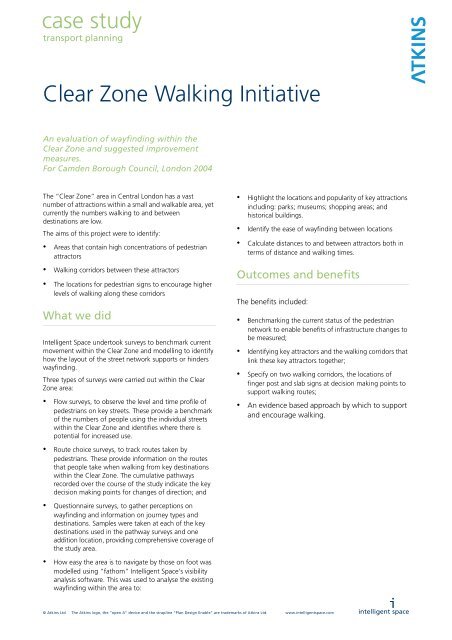
The “Clear Zone” area in Central London has a vast<br />
number <strong>of</strong> attractions within a small and walkable area, yet<br />
currently the numbers walking to and between<br />
destinations are low.<br />
The aims <strong>of</strong> <strong>this</strong> <strong>project</strong> were to identify:<br />
• Areas that contain high concentrations <strong>of</strong> pedestrian<br />
attractors<br />
• Walking corridors between these attractors<br />
• The locations for pedestrian signs to encourage higher<br />
levels <strong>of</strong> walking along these corridors<br />
What we did<br />
<strong>Intelligent</strong> <strong>Space</strong> undertook surveys to benchmark current<br />
movement within the Clear Zone and modelling to identify<br />
how the layout <strong>of</strong> the street network supports or hinders<br />
wayfinding.<br />
Three types <strong>of</strong> surveys were carried out within the Clear<br />
Zone area:<br />
• Flow surveys, to observe the level and time pr<strong>of</strong>ile <strong>of</strong><br />
pedestrians on key streets. These provide a benchmark<br />
<strong>of</strong> the numbers <strong>of</strong> people using the individual streets<br />
within the Clear Zone and identifies where there is<br />
potential for increased use.<br />
• Highlight the locations and popularity <strong>of</strong> key attractions<br />
including: parks; museums; shopping areas; and<br />
historical buildings.<br />
• Identify the ease <strong>of</strong> wayfinding between locations<br />
• Calculate distances to and between attractors both in<br />
terms <strong>of</strong> distance and walking times.<br />
Outcomes and benefits<br />
The benefits included:<br />
• Benchmarking the current status <strong>of</strong> the pedestrian<br />
network to enable benefits <strong>of</strong> infrastructure changes to<br />
be measured;<br />
• Identifying key attractors and the walking corridors that<br />
link these key attractors together;<br />
• Specify on two walking corridors, the locations <strong>of</strong><br />
finger post and slab signs at decision making points to<br />
support walking routes;<br />
• An evidence based approach by which to support<br />
and encourage walking.<br />
• Route choice surveys, to track routes taken by<br />
pedestrians. These provide information on the routes<br />
that people take when walking from key destinations<br />
within the Clear Zone. The cumulative pathways<br />
recorded over the course <strong>of</strong> the study indicate the key<br />
decision making points for changes <strong>of</strong> direction; and<br />
• Questionnaire surveys, to gather perceptions on<br />
wayfinding and information on journey types and<br />
destinations. Samples were taken at each <strong>of</strong> the key<br />
destinations used in the pathway surveys and one<br />
addition location, providing comprehensive coverage <strong>of</strong><br />
the study area.<br />
• How easy the area is to navigate by those on foot was<br />
modelled using “fathom” <strong>Intelligent</strong> <strong>Space</strong>'s visibility<br />
analysis s<strong>of</strong>tware. This was used to analyse the existing<br />
wayfinding within the area to:<br />
© Atkins Ltd The Atkins logo, the “open A” device and the strapline “Plan Design Enable” are trademarks <strong>of</strong> Atkins Ltd. www.intelligentspace.com<br />
i<br />
intelligent space
UNDERGROUND<br />
UNDERGROUND<br />
UNDERGROUND<br />
UNDERGROUND<br />
UNDERGROUND<br />
UNDERGROUND<br />
UNDERGROUND<br />
UNDERGROUND<br />
UNDERGROUND<br />
UNDERGROUND<br />
UNDERGROUND<br />
UNDERGROUND<br />
UNDERGROUND<br />
UNDERGROUND<br />
UNDERGROUND<br />
UNDERGROUND<br />
UNDERGROUND<br />
case study<br />
transport planning<br />
healthcare<br />
CLEAR ZONE WALKING INITIATIVE<br />
WALKING CORRIDORS<br />
i<br />
intelligent space<br />
1<br />
1<br />
2<br />
4<br />
2<br />
3<br />
3<br />
5<br />
6<br />
8 7<br />
4 5<br />
6<br />
9<br />
11<br />
13<br />
12<br />
10<br />
7<br />
14<br />
15<br />
9<br />
17<br />
10<br />
8<br />
16<br />
18<br />
22<br />
12<br />
thames<br />
11<br />
19<br />
20<br />
21<br />
XX<br />
© intelligent space partnership 2005 intelligent space partnership 81 rivington street london EC2A 3AY t 020 7739 9729 f 020 7739 9547 info@intelligentspace.com www.intelligentspace.com<br />
XX<br />
Tube Station<br />
Suggested Slab Sign Location<br />
Slab Sign Number<br />
Suggested Fingerpost Location<br />
Key Walking Route<br />
Secondary Walking Route<br />
Attraction Number<br />
© Atkins Ltd The Atkins logo, the “open A” device and the strapline “Plan Design Enable” are trademarks <strong>of</strong> Atkins Ltd. www.intelligentspace.com<br />
1. Kings Cross / St. Pancras / British Library<br />
2. Euston Station<br />
3. University College London<br />
4. Tottenham Court Road / Charlotte Street<br />
5. British Museum and the Museum District<br />
6. Hatton Garden<br />
7. Oxford Street<br />
8. Regent Street<br />
9. Covent Garden<br />
10. King’s College<br />
11. Trafalgar Square / Leicester Square /<br />
National Gallery<br />
12. Somerset House<br />
i<br />
intelligent space


