

Download 28.1 Mb pdf - IRIS
Download 28.1 Mb pdf - IRIS
Download 28.1 Mb pdf - IRIS

Create successful ePaper yourself
Turn your PDF publications into a flip-book with our unique Google optimized e-Paper software.
T h e I R I S P r o p o s a l
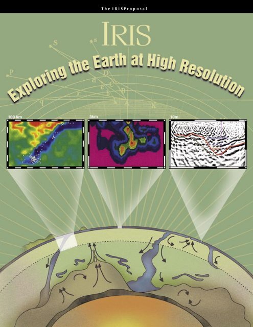
About the Cover<br />
From 100-kilometer structures in the mantle to 1-meter features within a paleochannel, the images on our<br />
cover span five orders of magnitude and illustrate how <strong>IRIS</strong> instrumentation and facilities are improving our<br />
ability to explore the Earth at high resolution and at all scales.<br />
Bottom figure: This cartoon cross-section through the Earthʼs interior illustrates possible dynamics of the<br />
deep mantle. Depth to the dense layer in the lower mantle ranges from ~1600 km in some areas to ~2700<br />
km near the core/mantle boundary, where it is deflected by downwelling slabs. Plumes rise from local high<br />
spots, carrying recycled slab material and some primordial material. High resolution PASSCAL and GSN<br />
data are used to study scattered waves and S-and P-wave velocity anomalies in the deep mantle, thus advancing<br />
our understanding of this region.<br />
From: Kellogg, L. H., B. H. Hager and R.D. van der Hilst, Compositional Stratification in the Deep<br />
Mantle, Science, 283, 1881-1884, 1999.<br />
Left inset: This image depicts an east-west vertical cross-section of P-wave velocity across the Lau ridge<br />
and the Tonga arc. In a two-year deployment, 12 PASSCAL broad-band instruments were used to increase<br />
seismic coverage south of the <strong>IRIS</strong> GSN station AFI on Samoa. Earthquakes within a 40-km width from the<br />
cross-section are shown as white circles. P-wave velocity perturbation ranges from -6% (red) to 0% (green)<br />
and 6% (blue). This study provides evidence that the geodynamic systems associated with back-arc spreading<br />
are related to deep processes such as the convective circulation in the mantle wedge and deep dehydration<br />
reactions in the subducting slab.<br />
From: Zhao, D., Y. Xu, D. Wiens, L. Dorman, J. Hildebrand, S. Webb, Depth Extent of the Lau Back-Arc<br />
Spreading Center and its Relation to Subduction Processes, Science, 278, 254-257, 1997.<br />
Middle inset: This figure shows the dynamic slip distribution for the 16 October 1999 Hector Mine earthquake<br />
in the Mojave Desert of Southern California. It illustrates how regional and teleseismic broadband<br />
data may be used to determine the kinematic parameters of large earthquakes. The model fault plane in this<br />
figure extends 60 km SE-NW and 20 km in the dip direction. Through inversion of the broadband data, the<br />
spatial extent of the fault rupture can be determined. In this figure, each color gradation is equivalent to slip<br />
increments of 1 m. The inversion reveals a peak slip of 8 meters (red), while the distribution of slip shows<br />
that the event had a bilateral rupture.<br />
From: Dreger, D. S., and A. Kaverina, Seismic Remote Sensing for the Earthquake Source Process and<br />
Near-Source Strong Shaking: A Case Study of the October 16, 1999 Hector Mine Earthquake, Geophysical<br />
Research Letters, (in press) 2000.<br />
Right inset: This high resolution seismic profile was used to map groundwater contamination at Hill Air<br />
Force Base, Utah. The pre-stack depth migrated seismic section is 35 meters long and extends to a depth of<br />
17 meters. The seismic data were acquired using a 60 channel <strong>IRIS</strong> Geometrics and a 60 channel Rice Bison<br />
portable seismograph. Geophones were spaced at 30-cm intervals along the profile. Pre-stack depth migration<br />
and depth focusing analysis produced clear images of a paleochannel (red line). The site is contaminated<br />
by a dense non-aqueous phase liquid (DNAPL) solvent that resides at the base of a shallow (
“Exploring the Earth at High Resolution”<br />
the <strong>IRIS</strong> Proposal<br />
July 1, 2001 - June 30, 2006<br />
submitted to the<br />
National Science Foundation<br />
Division of Earth Sciences<br />
Instrumentation and Facilities Program<br />
by the<br />
96 Member Research Institutions<br />
of the<br />
<strong>IRIS</strong> Consortium<br />
Incorporated Research Institutions for Seismology<br />
1200 New York Avenue, NW, Suite 800<br />
Washington, D.C. 20005<br />
August, 2000
ABOUT THIS PROPOSAL<br />
This proposal was produced by the <strong>IRIS</strong> Executive Committee on behalf of the <strong>IRIS</strong> Board of Directors, who in<br />
turn, represent the full membership of the Consortium. Developing a single proposal that represents the collective<br />
scientific interests of almost 100 research institutions is a complex task. It requires identifying the common vision,<br />
agreeing upon the next generation of data needs, choosing methodologies, and setting priorities across a broad range<br />
of scientific sub-disciplines. Although the formal process of this proposal development began in the Spring of 1999,<br />
the review, auditing, and self-evaluation that forms the background for this proposal has been an on-going process<br />
within <strong>IRIS</strong>. Text in this proposal has been contributed by members of the 1999 <strong>IRIS</strong> workshop, the <strong>IRIS</strong> Science Task<br />
Force, the Standing Committees, the Coordinating Committee, the Planning Committee, members of the Executive<br />
Committee and <strong>IRIS</strong> staff.<br />
This proposal consists of three main sections:<br />
The main proposal includes an overview of the <strong>IRIS</strong> Consortium and facilities, the role of <strong>IRIS</strong> in supporting<br />
research and education, a description of our resource needs, and a brief outline of our five-year funding request.<br />
Appendix I is a review of our accomplishments over the last 5 years. It includes more than 120 one-page contributed<br />
vignettes, which describe projects that have made use of <strong>IRIS</strong> facilities and resources, and a one-year example of<br />
publications based on <strong>IRIS</strong> data.<br />
Appendix II is an overview of core <strong>IRIS</strong> facilities. This section contains a review of the development and evolution<br />
of these facilities and descriptions of plans and resource requests for each of the <strong>IRIS</strong> programs.<br />
------------------------------------------------------------------------------------------------------------<br />
Executive Committee Standing Committee Chairs Senior Staff<br />
Anne Meltzer,<br />
Chair, Lehigh Univerisity<br />
Goran Ekstrom,<br />
Vice Chair, Harvard University<br />
Michael Wysession,<br />
Secretary, Washington University<br />
Thomas Jordan,<br />
University of Southern California<br />
Stephen Malone,<br />
University of Washington<br />
Gary Pavlis,<br />
Indiana University<br />
Peter Shearer,<br />
University of California, San Diego<br />
Clifford Thurber,<br />
University of Wisconsin, Madison<br />
Lawrence Braile,<br />
E&O, Purdue University<br />
Roy Johnson,<br />
PASSCAL, University of Arizona<br />
Alan Levander,<br />
DMS, Rice University<br />
Barbara Romanowicz,<br />
GSN, University of<br />
California, Berkeley<br />
David Simpson,<br />
President<br />
Gregory van der Vink,<br />
Director of Planning<br />
Timothy Ahern,<br />
DMS Program Manager<br />
Rhett Butler,<br />
GSN Program Manager<br />
James Fowler,<br />
PASSCAL Program Manager<br />
Catherine Johnson,<br />
E&O Program Manager<br />
Candy Shin,<br />
Business Manager
EXPLORING THE EARTH AT HIGH RESOLUTION<br />
THE <strong>IRIS</strong> PROPOSAL<br />
Table of Contents<br />
PROJECT DESCRIPTION<br />
• Integrating Facilities and Research ............................................................. 1<br />
• Science Supported by <strong>IRIS</strong> Facilities ......................................................... 9<br />
• What is Proposed ........................................................................................ 19<br />
• Program Implementation ............................................................................ 25<br />
APPENDIX 1 – THE IMPACT OF <strong>IRIS</strong> ON THE GEOSCIENCES<br />
• Introduction................................................................................................. i<br />
• Table of Contents......................................................................................... ii<br />
• One-Page Descriptions................................................................................ I-1<br />
• Sample Publication List............................................................................... I-129<br />
APPENDIX 2 – <strong>IRIS</strong> PROGRAMS<br />
• Overview..................................................................................................... II-1<br />
• The Global Seismographic Network........................................................... II-5<br />
• The PASSCAL Program.............................................................................. II-15<br />
• The Data Management System................................................................... II-27<br />
• The Education and Outreach Program........................................................ II-37
PROJECT DESCRIPTION<br />
Integrating Facilities and Research...................................................................... 1<br />
Introduction.................................................................................................. 1<br />
<strong>IRIS</strong> – A Brief Overview.............................................................................. 2<br />
Facility Themes............................................................................................ 3<br />
The Need for Higher Resolution...................................................... 4<br />
The Need for Long-Term Coverage................................................. 5<br />
High Performance............................................................................ 7<br />
Linking Facilities, Research and Education .................................... 7<br />
Science Supported by <strong>IRIS</strong> Facilities .................................................................. 9<br />
Lithospheric Structure and Dynamics.......................................................... 9<br />
Volcanic Processes and Magmatism............................................................ 11<br />
Global Tomography and Mantle Convection............................................... 13<br />
Heterogeneity in the Lowermost Mantle and Core...................................... 15<br />
Earthquakes, Faults and Deformation .......................................................... 16<br />
What is Proposed.................................................................................................. 19<br />
Primary Budget Components....................................................................... 19<br />
Core Operations............................................................................... 19<br />
Upgrade and Replacement of Previous Investments....................... 20<br />
Addition of New Resources ............................................................ 21<br />
Integrated Activities ........................................................................ 22<br />
Program Implementation...................................................................................... 25<br />
Consortium Governance and Management.................................................. 25<br />
Facility Management........................................................................ 25<br />
Program Planning............................................................................. 27<br />
Fiscal and Audit Controls................................................................. 27<br />
Community Activities .................................................................................. 27<br />
Evolution of <strong>IRIS</strong> Funding........................................................................... 29
INTEGRATING FACILITIES AND RESEARCH<br />
INTRODUCTION<br />
From Galileoʼs telescope and Leeuwenhoekʼs<br />
microscope to the high technologies of the present day,<br />
many of the great discoveries in science have come from<br />
new tools that sharpen our images of nature. In just the<br />
last decade, the Hubble Space Telescope has extended the<br />
range of optical astronomy toward the outer reaches of the<br />
Universe, revealing its turbulence in the wake of the Big<br />
Bang. Atomic-force microscopes are being used to map<br />
the topography of individual atoms on material surfaces,<br />
enabling rapid progress in nanotechnology. Medicine<br />
is advancing through computer-aided tomography and<br />
magnetic-resonance imaging of the<br />
human body. Multispectral cameras<br />
aboard satellites and multibeam<br />
sonars on ships are enhancing our<br />
views of the terrestrial surface over<br />
the land and beneath the sea.<br />
In a similar way, the new tools<br />
of seismological imaging are<br />
revolutionizing the study of the solid<br />
Earth. Earthquakes and controlled<br />
sources such as underground<br />
explosions generate elastic waves<br />
that encode an immense amount<br />
of information about the Earth<br />
through which they propagate. This<br />
information can be captured on arrays<br />
of seismic sensors and digitally<br />
processed into three-dimensional<br />
images of Earth structure and moving<br />
pictures of earthquake ruptures.<br />
Seismology thus gives geoscientists<br />
the eyes to observe fundamental<br />
processes within the depths of our<br />
planetʼs interior.<br />
Seismology provides the highest<br />
resolution techniques available for<br />
exploring the interior of the Earth and connecting surface<br />
geological observations to deeper Earth structure. By doing<br />
so, we can begin to develop a systems approach that ties<br />
the complexity of surface tectonics with phenomena deep<br />
in the Earth. Continued progress, however, requires both<br />
data with higher resolution and the perspective provided by<br />
long-term coverage. Studies of the Earthʼs dynamic systems<br />
requires a commitment to observations that are:<br />
• high-performance – to capture the full fidelity of Earthʼs<br />
signals,<br />
• long-term – to allow observations of change and unique<br />
rare events, and<br />
• high-resolution – to allow observation of detailed<br />
structure.<br />
Combined, these observational resources provide<br />
scientists with the tools to study the dynamic processes<br />
that reveal the way in which the planet is structured and<br />
Global Coverage<br />
The Global Seismographic Network has been a major contributor, in partnership<br />
with other national and international networks, in creating a global 2000-km grid of<br />
permanent seismological observatories, covering the continents and most of the<br />
worldʼs oceans.<br />
evolves, at a variety of temporal and spatial scales.<br />
As the National Science Foundation (NSF) celebrates<br />
its 50 th anniversary, it has identified “People, Ideas,<br />
Tools” as the cornerstones of its new Strategic Plan. The<br />
explicit commitment to facilities as an underpinning of<br />
NSF-supported research is echoed in both the Geoscience<br />
Directorateʼs “NSF Geosciences Beyond 2000” and “GEO<br />
Facilities Long-Range Plan”. These documents reflect a<br />
1
Global Data<br />
Delivery<br />
Open and free<br />
access to data<br />
from the Global<br />
Seismographic<br />
Network, PASSCAL<br />
and cooperating<br />
networks are<br />
provided through<br />
the <strong>IRIS</strong> Data<br />
Management System<br />
to researchers and<br />
educators anywhere<br />
in the world.<br />
growing awareness of the Foundationʼs need to balance<br />
its support of basic research with a commitment to the<br />
observational and data management tools required to<br />
stimulate and support research and exploration. At the same<br />
time, by including “People” as a key element in its Strategic<br />
Plan, NSF underscores its commitment to the educational<br />
process, and emphasizes the importance of communicating<br />
our data, results, and experience to the public in ways that<br />
are stimulating and accessible.<br />
Under the three previous five-year Cooperative<br />
Agreements between the <strong>IRIS</strong> Consortium and NSF, we<br />
have established core facilities – the tools of seismology<br />
– that have become an essential part of the fabric of<br />
domestic and international research in seismology and<br />
the Earth sciences. The <strong>IRIS</strong> facilities were established<br />
with a commitment to high-performance in quality of<br />
instrumentation, data resources and user services. Through<br />
careful planning and constant re-evaluation, these tools<br />
have evolved and grown in response to the changing needs<br />
of the research community. In this proposal, we present a<br />
plan that continues that tradition of excellence; extends the<br />
facilities to higher resolution; establishes a pathway to an<br />
enduring, long-term commitment to global observations and<br />
preservation of data resources; and encourages public and<br />
educational involvement in the excitement of seismological<br />
discovery.<br />
<strong>IRIS</strong> – A BRIEF OVERVIEW<br />
<strong>IRIS</strong>, a consortium of 96 universities and research<br />
organizations, has become a cornerstone of academic<br />
research in seismology. <strong>IRIS</strong> maintains and operates<br />
national and global facilities: permanent networks for longterm<br />
monitoring, portable instruments for high-resolution<br />
imaging, and a data archive that makes seismic data<br />
available to a broad spectrum of scientists and educators.<br />
These facilities enable cutting-edge research at academic<br />
institutions across the US, from traditional major research<br />
institutions, to universities with combined research and<br />
education missions, to four-year liberal arts and technical<br />
colleges.<br />
<strong>IRIS</strong> operates on the foundation of shared resources and<br />
a consortium philosophy that is inherent to the science of<br />
seismology. Little can be done with data from a single<br />
seismogram. While each individual earthquake and<br />
experiment contributes towards unraveling our Earthʼs<br />
structure, collectively they provide the opportunity to<br />
build a more complete and coherent understanding of<br />
whole Earth structure and dynamic processes. Sharing<br />
resources, instruments and data maximizes the return on<br />
capital investments, but also promotes intellectual discourse<br />
and scientific interactions.<br />
Fifteen years ago, only about a half-dozen research<br />
institutions in the US could support the facilities required<br />
for advanced observational seismology. The technical<br />
requirements for maintaining instruments, fielding<br />
experiments, and handling large data sets prohibited all<br />
but a few from having access to high-quality data sets and<br />
state-of-the-art instrumentation. Today, a new generation<br />
of scientists has been empowered by <strong>IRIS</strong>. Every scientist<br />
and student with a connection to the Internet now has<br />
access to data from global, regional, and local networks<br />
around the world. Any individual investigator can now<br />
propose an experiment without the burden of establishing<br />
an in-house technical capability. The past infrastructure<br />
barriers to seismology have been torn down – making our<br />
science and data available to new audiences of researchers<br />
and educators.<br />
This proposal requests funds from the National Science<br />
Foundation to maintain and operate the core <strong>IRIS</strong> programs<br />
as an integrated, state of the art, national facility in support<br />
of seismological research. The core <strong>IRIS</strong> programs<br />
include:<br />
The Global Seismographic Network (GSN)<br />
– a permanent worldwide network of over 130 broadband<br />
seismological observatories,<br />
The Program for the Array Seismic Studies of the<br />
Continental Lithosphere (PASSCAL) – a program of<br />
portable instruments for use by individual scientists for<br />
high-resolution experiments in areas of special interest,<br />
The Data Management System (DMS) – a data system<br />
2
Crustal Scale Faulting<br />
PASSCAL instruments have been used in a<br />
number of experiments both on land and in<br />
“onshore - offshore” confi gurations recording<br />
both explosions and earthquakes to study<br />
the structure of the western margin of the US<br />
from California to Alaska. The top map and<br />
cross section show velocity, seismic refl ectivity<br />
(black), and seismicity (white) across the San<br />
Andreas Fault system south of the Mendocino<br />
Triple Junction in northern California. Offsets<br />
can be seen in the lower crustal layer beneath<br />
the surface expression of the San Andreas<br />
fault system. (Figure provided by Alan<br />
Levander, Rice University).<br />
The lower cross sections show similar results<br />
obtained along the San Andreas Fault in<br />
southern California using teleseismic receiver<br />
functions and active source profi ling. (Figure<br />
provided by Lupei Zhu, Caltech)<br />
These images provide evidence that the faults<br />
of the transform system cut through the entire<br />
crustal column to the mantle at high angle and<br />
are associated with both brittle faulting in the<br />
upper crust and ductile deformation at depth.<br />
Additional details are provided in Appendix I.<br />
125W 124W 123W<br />
40 00'N<br />
39 30'N<br />
Depth (km)<br />
for collecting, archiving, and distributing data from <strong>IRIS</strong><br />
facilities, as well as a number of other national and<br />
international networks and agencies, and<br />
The Education and Outreach Program (E&O) – a<br />
program that integrates research and education by making<br />
our data and science widely accessible through a variety<br />
of innovative programs and partnerships.<br />
The GSN and PASSCAL are complementary programs<br />
and the primary tools for the acquisition of new data,<br />
designed for global coverage with flexible resolution. The<br />
GSN, along with other cooperating networks, provides a<br />
baseline coverage of approximately 2000 kilometers on<br />
the continents and oceanic islands worldwide. Denser<br />
deployments of PASSCAL instruments allow investigations<br />
of specific targets with resolution on the order of 100s of<br />
kilometers down to the sub-meter scale. The DMS and<br />
E&O are also complementary programs and the primary<br />
means of distributing data for research and education. By<br />
combining and distributing data from different sources,<br />
the DMS allows individual investigators to assemble data<br />
products tailored to their research objectives. The DMS<br />
also serves as a forum to coordinate international<br />
cooperation, set data and software standards, and promote<br />
data exchange. The E&O program integrates seismological<br />
data with educational programs and public outreach,<br />
making our data available and useable, not only for research<br />
seismologists, but also for educational institutions and the<br />
interested public. The E&O program plays an important<br />
role in translating scientific results on Earth structure and<br />
dynamics into terms meaningful and accessible to the<br />
general public.<br />
0<br />
10<br />
20<br />
30<br />
Land shots<br />
Offshore shots<br />
Modeled offshore shot<br />
OBS locations<br />
Land receivers<br />
Onshore-offshore receivers<br />
Earthquakes<br />
SAF<br />
MF<br />
W<br />
SAF Coast MF BSF E<br />
-100 -75 -50 -25 0 25 50 75 100<br />
BSF<br />
1.5 3.5 5.5 7.5 8.5<br />
P-wave seismic velocity (km/s)<br />
4 Zh u<br />
Depth (km)<br />
∆g (mgal)<br />
Depth (km)<br />
A<br />
LAB<br />
0<br />
-10<br />
-20<br />
-30<br />
-40<br />
0.2<br />
SAF<br />
0.2<br />
Mojave Desert<br />
-50<br />
-40 -30 -20 -10 0 10 20 30 40 50 60 70 80 90 100<br />
B<br />
-60<br />
-80<br />
-100<br />
-120<br />
LAB<br />
0<br />
-10<br />
-20<br />
-30<br />
-40<br />
SMF<br />
Under its Cooperative Agreement with the National<br />
Science Foundation, the <strong>IRIS</strong> Consortium accepts the<br />
obligation to establish and maintain the observational<br />
resources required to support NSF-funded research in<br />
seismology, and to enhance those resources in response<br />
to the evolving needs of the research community. As the<br />
0.1<br />
0.1<br />
0.1<br />
0.1<br />
0.1<br />
0.2<br />
ECSZ<br />
-0.150 -0.100 -0.050 0.000 0.050 0.100 0.150<br />
Amplitude<br />
VCT<br />
SAF<br />
Mojave Desert<br />
Upper Crust<br />
Lower Crust<br />
Upper Mantle<br />
Moho<br />
ECSZ<br />
-50<br />
-40 -30 -20 -10 0 10 20 30 40 50 60 70 80 90 100<br />
Figure 3. (A) The amplitude and v ariance (giv en b y the con tours)<br />
except that the surface<br />
Distance from<br />
top<br />
fault<br />
ograph<br />
trace,<br />
ykmis<br />
ampli ed b y a factor of<br />
Basin. (B) Crustal structure along the pro le based on A. The t<br />
v elo cit y discon tin uities. SMF: Sierra Madre F ault; V CT: Vicen<br />
the pro le b et w een 1981and 1998. Green lines are the crustal re<br />
the upp er man tle represen ts the T ransv erse Range high v ectors elo cit<br />
on theFACILITY top are the THEMES observ ed Bouguer gra vit y anomaly [23, ] and th<br />
determined Moho top ograph y (dashed line) and the Airy is<br />
0.2<br />
3
CB<br />
20<br />
40<br />
Proterozoic<br />
Archean<br />
60<br />
80<br />
LVZ<br />
infertile<br />
peridotite<br />
LVZ<br />
multiples<br />
100<br />
120<br />
layered<br />
eclogite<br />
fertile<br />
peridotite<br />
New Analytical Techniques<br />
New techniques are being developed to image the lower crust<br />
and upper mantle by extracting P-to-S converted and scattered<br />
phases from the incident wavefi eld of teleseismic events,<br />
recorded on arrays of broadband PASSCAL instruments. The<br />
image on the left is an application of an enhanced migration<br />
scheme applied to a magnitude 6.3 South American subduction<br />
zone event recorded by the Lodore array of broadband<br />
PASSCAL instruments in northwestern Colorado (Figure<br />
provided by Gary Pavlis, Indiana University).<br />
The image on the right shows both P- and S-velocity<br />
perturbations derived from simultaneous inversion of scattered<br />
teleseismic P-waves from 30 earthquakes recorded on the<br />
E-W Cascadia profi le in central Oregon. (Figure from Michael<br />
Bostock, University of British Columbia) More information on<br />
both techniques is provided in Appendix I.<br />
members of the <strong>IRIS</strong> Consortium have been engaged in<br />
the development of this proposal, four general themes have<br />
emerged to guide our activities over the next five years:<br />
Higher Resolution – Against a backdrop of global<br />
tectonic fabric, the PASSCAL program has demonstrated<br />
the importance and practicality of high-resolution seismic<br />
imaging to illuminate structures and processes at local<br />
and regional scales. Combined with other geological and<br />
geophysical techniques, and with enhanced interpretative<br />
tools, seismology is poised to make significant new<br />
contributions to investigating Earth structure. This requires<br />
an investment in additional instrumentation to meet the<br />
growing demands for higher density observations of<br />
different tectonic environments and the deeper Earth.<br />
Long-term Coverage - The Global Seismographic<br />
Network has now reached its design goal of uniform<br />
coverage over the continents and much of the worldʼs<br />
oceans. The <strong>IRIS</strong> Data Management System has constructed<br />
the hardware and software resources that ensure long-term<br />
return on PASSCAL and GSN investments in data collection,<br />
through effective means for quality control, archiving and<br />
distribution. With our partners in the US Geological Survey,<br />
we need to ensure the long-term operation and maintenance<br />
of these resources. This will require a commitment, on our<br />
part as operators, to manage these facilities efficiently,<br />
and, on the part of NSF and USGS as funding agencies,<br />
to provide the required financial support for operation and<br />
maintenance.<br />
High Performance – The instruments that <strong>IRIS</strong> provides<br />
through its core programs must evolve and be upgraded<br />
to maintain the highest technical standards and to take<br />
advantage of emerging technologies. At the same time, the<br />
full facility – including personnel, management, software,<br />
training, operational support and membership services<br />
– must continue to serve the research community in an<br />
effective and efficient manner. This requires the continued<br />
investment in tools, technology, and people to maintain the<br />
excellence and quality associated with a national facility.<br />
Linking Facilities, Research and Education – The<br />
<strong>IRIS</strong> Consortium, whether through the data resources of<br />
its facilities or the intellectual resources of its members,<br />
has a responsibility and a unique opportunity to bring the<br />
excitement and intellectual challenges of earthquakes and<br />
seismology to the public and the classroom. This requires<br />
investments in education to communicate our scientific<br />
results in meaningful ways to a broad audience and to<br />
make the data acquired through <strong>IRIS</strong> facilities accessible<br />
to non-scientists in ways that are useful.<br />
The Need for Higher Resolution<br />
Just as the first microscopes revealed that a seemingly<br />
simple drop of clear pond water was in fact a complex ocean<br />
teaming with microscopic life, detailed seismographic<br />
studies are now beginning to show us a fabric within the<br />
Earthʼs interior that previously lay hidden within the coarser<br />
scales of earlier studies. A fundamental goal of the <strong>IRIS</strong><br />
program is to provide the seismological community with<br />
the necessary instrumentation to image the internal structure<br />
4
of the Earth with sufficient resolution to answer important<br />
geoscience questions. There is an increasing recognition<br />
that 2-D transects, while important, are insufficient to<br />
describe the inherent complexity of Earth systems. 3-D<br />
observations are required to fully explore the rich diversity<br />
of lithospheric and deep Earth structure. With current limits<br />
on the numbers and complexity of instruments, investigators<br />
must generally choose between 3-D experiments with<br />
insufficient resolution, or 2-D experiments with good<br />
resolution but whose interpretation requires simplifying<br />
assumptions about Earth structure.<br />
Recent studies utilizing high-resolution seismic data<br />
illustrate the power of adequate resolution in understanding<br />
solid Earth systems and their interactions. PASSCAL<br />
experiments in the western US, South America, and Asia<br />
have shown that high topography, previously believed to be<br />
supported by low density crustal roots, is instead supported<br />
by low-velocity mobile mantle material. Crustal scale<br />
strike-slip faulting and pervasive, orogen-wide detachment<br />
faults penetrate the underlying mantle, implying a degree<br />
of mantle control on crustal structure in orogenic belts<br />
and along plate boundaries. At the same time, recycling of<br />
crustal material and de-watering within subduction zones,<br />
and delamination and phase change of mafic lower crust<br />
beneath orogenic belts, exert crustal control on upper mantle<br />
structures. Measurements of anisotropy in the crust, where<br />
caused by fluid filled cracks, can be used to infer current<br />
tectonic stress, and where caused by rock fabric, to indicate<br />
past crustal strain. Tantalizing images suggest the presence<br />
of melts and aqueous fluids in the crust, which may be<br />
important factors in controlling lithospheric structure and<br />
dynamics.<br />
Where high resolution data are available, imaging of<br />
fault zones, characterizations of fault zone processes, and<br />
mapping of fault networks provide a better understanding<br />
of the complexity of earthquake nucleation, rupture, and<br />
propagation, and provide data for input into earthquake<br />
simulations. In magmatic systems, tomographic images<br />
utilizing dense ray-path coverage have resolved conduits<br />
and magma chambers and high-precision earthquake<br />
locations have been used to map magma migration.<br />
Systematic application of 2-D profiling, vertical seismic<br />
profiling, 3-component acquisition, and 3-D data analysis<br />
in the near-surface for detailed structural, environmental,<br />
and groundwater studies, provide the best opportunity<br />
to characterize velocity and density variations and<br />
unequivocally link these parameters directly to subsurface<br />
geology, groundwater saturation, and flow paths.<br />
In the deeper Earth, high-resolution data sets from both<br />
PASSCAL and GSN trace the plumes associated with<br />
hotspots deep into the mantle. We can image descending<br />
slabs well into the mid-mantle, and in some cases tie them<br />
to structures near the core-mantle boundary. Measurement<br />
of in-situ anisotropy, reflecting the influence of strain on<br />
the alignment of olivine crystals, can be used to map<br />
deformation patterns in the mantle lithosphere and flow<br />
of the sub-lithospheric mantle. Core-diffracted seismic<br />
5<br />
phases suggest regions of possible partial melt just above<br />
the core-mantle boundary.<br />
The complex assemblages of crust and mantle rock that<br />
make up the continental lithosphere exhibit a great degree<br />
of lateral and vertical heterogeneity. The scarcity of highresolution<br />
data has forced us to average and extrapolate<br />
observations over large distances. To fully understand<br />
the dynamic processes that shape the Earth and to link<br />
observations made at the Earthʼs surface with underlying<br />
structure requires recording an unaliased wavefield in<br />
three dimensions. This requires denser sampling of the<br />
wavefield in both the temporal and spatial domain as well<br />
as advances in imaging science that take advantage of<br />
the wealth of information recorded in the full wavefield.<br />
Today, regardless of the scale of the investigation, there<br />
is a real need for high-resolution data as we expand both<br />
ends of the imaging spectrum from investigation of nearsurface<br />
environments on the scale of meters to images<br />
encompassing the whole lithosphere and deeper Earth. Our<br />
goal is to achieve the desired resolution routinely in three<br />
dimensions. Recent advances in instrumentation that take<br />
advantage of new technology to produce cheaper and easier<br />
to deploy instruments make reaching this goal feasible.<br />
The Need for Long-Term Coverage<br />
Each time a significant earthquake occurs, we have an<br />
opportunity to learn about tectonic processes, and sample<br />
part of the Earthʼs interior, as the waves produced by the<br />
earthquake travel to seismic stations around the world.<br />
Although the public perceives earthquakes as unusual<br />
events, on a global scale they occur often enough to<br />
allow a facility that monitors the Earth on a time-scale<br />
of decades to resolve in four-dimensions processes such<br />
as the highly variable rates (decades to days) at which<br />
magma accumulates and migrates in the upper mantle and<br />
crust, the possible differential rotation of the inner core,<br />
and the processes through which strain accumulates over<br />
decades in fault systems and is released in seconds through<br />
earthquakes.<br />
The scientific value of long-term operation of a global<br />
network of seismographic stations is realized in several<br />
ways. Seismographic stations are necessary for the<br />
detection, location, and characterization (e.g., size, focal<br />
mechanism and rupture process) of earthquakes. A time<br />
series of earthquake activity, accumulated over years,<br />
decades or centuries of observations, is the key datum for<br />
studies of seismicity patterns, seismic cycles, and, more<br />
generally, regional tectonic loading and deformation. Highquality<br />
observations and long time series are both essential<br />
for these investigations. In addition, studies of large and<br />
otherwise rare or unusual earthquakes are particularly<br />
important for providing constraints on the earthquake<br />
generation process.<br />
It is worth noting that there have been no truly large<br />
(M≥8.5) earthquakes during the last 25 years (1976-2000),<br />
while there were six in the period 1950-1975, among them<br />
the M=9.5 Chile and M=9.2 Alaska earthquakes. With the
instrumentation available at the time, none of these very<br />
large earthquakes were recorded on-scale, and their source<br />
processes are correspondingly poorly understood. These<br />
infrequent but large events are the major contributors<br />
to the energy and strain release during an earthquake<br />
cycle. The GSN will, by design, be able to capture the<br />
next M=9.0 earthquake on-scale across the entire seismic<br />
frequency band, providing a unique data set for studies of<br />
the earthquake source process.<br />
Long-term observations are necessary to collect the<br />
large data sets of travel times and waveforms that are<br />
necessary for global tomographic studies. The nonuniform<br />
distribution of seismic sources in both time and<br />
Number of Earthquakes<br />
Unique within 1 degree<br />
Unique within 2 degrees<br />
Unique within 5 degrees<br />
0 5 10 15 20 25<br />
YEARS<br />
Unique Events<br />
Earthquakes generally occur where earthquakes have occurred<br />
in the past. In this fi gure, a ʻuniqueʼ event is defi ned as one that<br />
does not have an earlier neighbor within 1, 2, and 5 degrees,<br />
based on earthquakes with moment magnitudes greater than 6<br />
in the Number Harvard of M>6 CMT earthquakes catalog. in Time the Harvard is measured CMT catalog, from for the eachstart of<br />
the year, CMT that catalog occurred in more 1975. than A 1, similar 2, or 5 pattern degrees away would from be all expected for<br />
other previous time periods. M>6 earthquakes In terms in the of catalog. sampling ʻuniqueʼ paths through<br />
the Earth and providing new information for tomographic studies,<br />
the value of a station or network is greatest during the fi rst 10-15<br />
years of operation. The distribution has a long tail, however,<br />
demonstrating the value of long-term operation. More than 50<br />
<strong>IRIS</strong> GSN stations have operated for less than 5 years. (Figure<br />
provided by Goran Ekstrom, Harvard University)<br />
space constitutes a major challenge to studies that image<br />
the three-dimensional structure of the Earthʼs interior. At<br />
present, the GSN comes close to providing the optimal<br />
station coverage that can be achieved, with land-based<br />
observatories, for moderate global-scale resolution of<br />
Earth structure. Global seismicity patterns now control the<br />
frequency at which paths through the Earth are illuminated<br />
and, correspondingly, the rate at which information about<br />
the three-dimensional structure accumulates. This rate<br />
is difficult to quantify, as the information that can be<br />
derived from a single earthquake depends not only on its<br />
location, but also its size and focal mechanism, as well as<br />
characteristics of stations that record the earthquake, such<br />
as typical noise levels. For example, <strong>IRIS</strong> GSN stations on<br />
remote island sites in the Pacific Ocean are providing unique<br />
new travel time, dispersion, and attenuation measurements<br />
for seismic wave paths through the Pacific mantle. Typical<br />
surf conditions at these islands, however, make the stations<br />
noisy, and only large earthquakes are well-recorded.<br />
While each well-recorded earthquake provides important<br />
constraints on Earth structure, new observations accumulate<br />
slowly and long-term observations are required to realize<br />
the benefits of the special station location.<br />
Long-term operation of seismographic observatories<br />
is also needed to record the seismic signals from rare<br />
earthquakes or other unexpected events. Such rare events<br />
may be nuclear tests and other man-made explosions, as well<br />
as natural phenomena such as volcanic eruptions, rock-falls,<br />
and meteoritic impacts, all of which have been observed<br />
and studied using GSN data. Long-term observations have<br />
recently been crucial for the discovery of Earthʼs continuous<br />
long-period oscillations, a phenomenon which probably is<br />
caused by the elastic coupling of the atmosphere or ocean<br />
with the solid Earth. Long-term global observations of<br />
seismic as well as other geophysical signals, such as<br />
barometric pressure, temperature, wind, currents, etc., are<br />
necessary to increase our understanding of how the various<br />
Earth systems interact.<br />
Experience has shown that the value of seismic networks<br />
and data archives grows with time. Even today, data from<br />
the 1960s WWSSN instruments and other analog networks<br />
are often “mined” for historical earthquakes with ray paths<br />
through structures that have not yet been sampled by more<br />
modern stations. The first images of the Farallon plate under<br />
North America were obtained from WWSSN data, as was<br />
some of the first evidence for discontinuous layering and<br />
ultra-low velocity zones above the core-mantle boundary.<br />
Researchers have searched records from old seismic stations<br />
in Alaska and Sweden for valuable clues regarding inner<br />
core rotation. In the long term, the easy access to modern<br />
digital archives will make GSN data even more valuable<br />
than those from the older stations.<br />
The GSN network is nearing its goal of global coverage.<br />
The PASSCAL program is providing high-quality<br />
instruments to over 50 experiments each year. The <strong>IRIS</strong><br />
DMC annually responds to tens of thousands of requests<br />
for data. If properly maintained, the scientific value of these<br />
programs and their potential to fuel new discoveries will be<br />
realized for decades to come. A significant part of the funding<br />
requested in this proposal is to ensure the long-term health<br />
of the investments made in the data collection and archival<br />
components of <strong>IRIS</strong>. That health will be maintained through<br />
carefully planned operation and maintenance of the existing<br />
facilities, attention to data quality, and improvements in<br />
operating procedures.<br />
High Performance<br />
Modern technology has given us the instrumental<br />
capabilities to sense, record, and store the full spectrum<br />
6
and dynamic range of ground motions from earthquakes<br />
and explosions. The standards established for <strong>IRIS</strong><br />
instrumentation and data handling have become a measure<br />
of “high performance” at the technical level for both<br />
national and international seismology. The Consortium<br />
continues to stimulate the application of new hardware<br />
and software to improve the quality of <strong>IRIS</strong> data and the<br />
efficiency of their collection and distribution. An important<br />
component of this proposal is to continue this tradition of<br />
high-performance. We will encourage the development of<br />
a new generation of portable instruments that are lighter<br />
in weight, lower in power consumption, and more robust.<br />
Emerging technologies for global and local telemetry will<br />
be used to extend the standards for high performance for<br />
data flow “from sensor to desktop”.<br />
An example of recent <strong>IRIS</strong> support of high performance<br />
technology is the PASSCAL telemetered broadband array,<br />
which demonstrates the advantages of real-time seismology<br />
for increasing efficiency, reducing cost, and improving data<br />
quality. Once installed in the field and operational, data<br />
from the array are transmitted via radio-modem or other<br />
communications channels to a central hub where they are<br />
linked to the Internet. The data and network performance<br />
then can be viewed and monitored in real-time from any<br />
location with an Internet connection, and instrument<br />
parameters can be modified remotely. Frequent visits for<br />
data recovery are not required and field visits need take<br />
place only when truly necessary. Data from the entire array<br />
are consolidated immediately, obviating the need for the<br />
time-consuming process of merging data from separate<br />
recorders, and data can flow seamlessly to the <strong>IRIS</strong> Data<br />
Management Center for archiving. The array can be used<br />
to locate seismicity in real-time, both within the experiment<br />
area and worldwide, and analysis can begin immediately<br />
to assure that science goals are being met.<br />
High performance must be maintained throughout <strong>IRIS</strong><br />
programs – not just through investment in instruments<br />
and equipment, but through the full resources that the<br />
Consortium provides, including data flow, data access,<br />
software support, education and outreach, and membership<br />
services.<br />
Linking Facilities, Research and Education<br />
Seismology is a scientific discipline that appeals<br />
to individuals of all ages. Through images of Earthʼs<br />
internal structure, seismology provides a look into the<br />
inner-workings of our planet. Earthquakes are spectacular<br />
events and the public is curious about where and why<br />
they occur and what they tell us about our Earth. Media<br />
attention to earthquakes can help the public recognize the<br />
importance of research in seismology and related Earth<br />
science. A strong public awareness of the Earth sciences<br />
is important in reducing risks and mitigating losses from<br />
earthquakes and from other natural hazards. The exciting<br />
and immediate aspect of earthquake seismology provides<br />
an educational gateway into broader aspects of the Earth<br />
and physical sciences.<br />
As a consortium of educational institutions with<br />
research interests in seismology, <strong>IRIS</strong> is in a unique<br />
position to establish and stimulate links between the<br />
Earth science research community and education. <strong>IRIS</strong><br />
members represent the highest level of national expertise<br />
in teaching seismology at the undergraduate and graduate<br />
level. Furthermore, many <strong>IRIS</strong> members are active in local<br />
outreach programs to primary and secondary schools and<br />
are a resource to radio, television and print media. As a<br />
national university consortium, <strong>IRIS</strong> can partner with NSF<br />
and other organizations at the national level, and with its<br />
members at the local level, to:<br />
• articulate major research results in seismology and the<br />
solid Earth sciences to the broader public,<br />
• provide a clearing house for educational materials<br />
related to seismology, and<br />
• help a variety of institutions to improve Earth science<br />
education in general, and seismology in particular.<br />
In 1997, <strong>IRIS</strong> initiated an Education and Outreach<br />
(E&O) program that contributes to formal and informal<br />
science education at all educational levels. <strong>IRIS</strong> E&O<br />
activities focus on integrating research and education<br />
in seismology and include research experiences for<br />
students, professional development for K-12 teachers<br />
and college faculty, collaborations with several major<br />
US museums, and the development of hard copy and<br />
electronic educational materials and resources. The <strong>IRIS</strong><br />
E&O program operates at both the national and local level:<br />
local initiatives are facilitated through involvement of the<br />
<strong>IRIS</strong> membership. For example, <strong>IRIS</strong> E&O sponsors<br />
workshops to introduce research seismologists to inquirybased,<br />
hands-on approaches to teaching Earth science at the<br />
K-12 level. Participants in these workshops can then assist<br />
in professional development of local teachers.<br />
The goals and activities of the <strong>IRIS</strong> E&O program<br />
are consistent with the 1996 National Science Education<br />
Standards that emphasize providing quality science<br />
education for all students at all levels of the curriculum,<br />
and involving students in learning science by doing science.<br />
In the next five years, we will continue our efforts to make<br />
seismological data easily accessible and more educationally<br />
useful, and to reach a significantly larger audience.<br />
7
Southern Africa Seismic Experiment<br />
P-Wave Velocity Perturbations<br />
Zimbabwe Craton ZIMBABWE<br />
~2.5-3.0 Ga<br />
20 o S<br />
NAMIBIA BOTSWANA<br />
20 o S<br />
Limpopo Mobile Belt<br />
~2.7 Ga<br />
Bushveld<br />
Complex<br />
~2.05 Ga<br />
Kheiss<br />
25 o S Thrust Belt<br />
25 o S<br />
~2.0 Ga<br />
20 o S<br />
25 o S<br />
SOUTH<br />
Kaapvaal Craton<br />
30 o S AFRICA<br />
~2.7-3.6 Ga<br />
30 o S<br />
30 o S<br />
Namaqua-Natal Mobile Belt<br />
~1.1-1.9 Ga<br />
Cape Fold Belt <strong>IRIS</strong>/GSN permanent<br />
~0.3 Ga<br />
<strong>IRIS</strong>/PASSCAL: Year 1<br />
<strong>IRIS</strong>/PASSCAL: Years 1 & 2<br />
35 o S <strong>IRIS</strong>/PASSCAL: Year 2 35 o S<br />
<strong>IRIS</strong>/PASSCAL: Kimberley BB<br />
20 o E 25 o E 30 o E 35 o E<br />
SAF99a1_P<br />
Depth = 200 km<br />
20 o E 25 o E 30 o E 35 o E<br />
35 o S<br />
-5000 -4000 -3000 -2000 -1000 0 1000 2000 3000 4000<br />
Topography (m)<br />
-1.0 -0.8 -0.6 -0.4 -0.2 0.0 0.2 0.4 0.6 0.8 1.0<br />
Velocity Perturbation (%)<br />
ROOTS OF ANCIENT CRATONS<br />
The southern Africa seismic experiment, summarized in the four<br />
fi gures shown here, was the largest broadband experiment ever<br />
undertaken at its time of deployment. The experiment was part of<br />
the multidisciplinary Kaapvaal Project, designed to enhance our<br />
understanding of continental formation, evolution and dynamics.<br />
Analysis of the broadband seismic data has produced dramatic<br />
high resolution images of the continental lithosphere and<br />
deeper mantle beneath the ancient core of southern Africa. The<br />
seismic studies were closely coordinated with geochemical and<br />
petrologic investigations of mantle samples rafted to the surface<br />
in kimberlite pipes. These integrated studies are revealing for<br />
the fi rst time the detailed anatomy of ancient continental roots,<br />
showing not only that they extend to depths as great as 250-300<br />
km, but also that they are highly depleted chemically relative to<br />
the rest of the mantle and that they are as old as the overlying<br />
crust.<br />
The map fi gure in the upper left shows locations of broadband<br />
stations deployed during 1997-1999 superimposed on principal<br />
geologic provinces and topography. The upper right fi gure is a<br />
horizontal section of velocity perturbations at 200 km depth. Blue<br />
indicates postive velocity anomalies and red indicates negative<br />
anomalies. Velocity structure was obtained from the tomographic<br />
analysis of teleseismic travel time delays for about 8000 P-<br />
wave rays recorded on the 82 stations of the broadband array.<br />
The two fi gures on the right are perspective views of volumes<br />
enclosing high and low P-wave velocity anomalies, plotted from<br />
75 to 670 km depth. The high-velocity regions are enclosed by<br />
blue surfaces, and the low-velocity regions by red surfaces.<br />
View of top image is from directly above the target region and<br />
shows boundaries of geologic provinces (yellow lines) as well<br />
as broadband station locations (white boxes). The view of the<br />
bottom image is from the southeast and above ground level.<br />
The tectospheric roots of the ancient (~3 Ga) Kaapvaal and<br />
Zimbabwe cratons are shown clearly as high velocity volumes<br />
extending 200 to 300 km beneath the surface expression of the<br />
Archean cratons. Low velocities in the upper mantle are seen<br />
beneath the Phanerozoic Cape Fold Belt of southernmost South<br />
Africa. The disruptive effect of the massive Bushveld layered<br />
intrusion (2.05 Ga) is evident as an intermediate velocity (neither<br />
blue nor red) E-W swath cutting through the northern region of<br />
the Kaapvaal craton.<br />
(Figure provided by Matt Fouch, John VanDecar, and David<br />
James, Department of Terrestrial Magnetism, Carnegie Institution<br />
of Washington)<br />
Cape Fold<br />
Belt<br />
Cape Fold<br />
Belt<br />
Namaqua-Natal<br />
Mobile Belt<br />
Namaqua-Natal<br />
Mobile Belt<br />
75 km<br />
Kaapvaal<br />
Craton<br />
Kaapvaal<br />
Craton<br />
670 km<br />
Zimbabwe<br />
Craton<br />
Bushveld<br />
Terrane<br />
Bushveld<br />
Terrane<br />
Zimbabwe<br />
Craton<br />
8
SCIENCE SUPPORTED BY <strong>IRIS</strong> FACILITIES<br />
While this proposal directly requests funding for the<br />
facilities of the <strong>IRIS</strong> programs, these facilities are of value<br />
to NSF and the scientific community primarily through the<br />
scientific research they support. In this section, we present<br />
examples of several questions and research directions<br />
that will be central to the Earth sciences during the next<br />
decade, and to which seismological research and the <strong>IRIS</strong><br />
facilities contribute significantly. The one-page vignettes<br />
that accompany this document, all contributed by users<br />
of <strong>IRIS</strong> facilities, provide a more comprehensive view<br />
of the wide range of scientific investigations which have<br />
developed as a result of NSFʼs investment in <strong>IRIS</strong>.<br />
LITHOSPHERIC STRUCTURE AND DYNAMICS<br />
Plate tectonics works well to explain the structure and<br />
dynamics of oceanic plates, but it does not provide an<br />
encompassing theory for evolution of the continents. The<br />
architecture of the lithosphere, acquired over the lifetime<br />
of the planet, records 95% of Earth history. The long-lived<br />
inherited structures and compositional variations modulate<br />
modern tectonic processes, and likely play a role in<br />
determining the patterns of the global convection system.<br />
A wide range of seismic methods from high-resolution<br />
seismic reflection profiling of the near surface to<br />
lithospheric-scale imaging with both active and passive<br />
source array experiments are now standard tools for<br />
extending geologic observations made at the surface to<br />
depth. In the past decade, the PASSCAL program has<br />
allowed for a remarkable increase in the deployment of<br />
experimental programs to understand the tectonic evolution<br />
of continents; how they have been assembled, disassembled,<br />
and altered with time; how the lithosphere is connected<br />
to the deeper mantle in global convection models; and<br />
how coupled surface and deep tectonic processes modify<br />
the lithosphere. These results, integrated with potential<br />
field, geochemical, and geologic data, point to previously<br />
unknown processes involved in continental dynamics.<br />
Surface wave studies using both GSN and PASSCAL<br />
data suggest that the base of the lithosphere extends to 200-<br />
250 km beneath most stable continental interiors, reaching<br />
depths as great as 300-400 km beneath some cratons. Such<br />
estimates are consistent with heat flow data and petrologic<br />
studies of mantle xenoliths. In places, this cool, chemically<br />
buoyant upper mantle material is mechanically coupled<br />
to overlying cratonic crust. In other places, the upper<br />
mantle merely acts as the edifice upon which a series of<br />
detached crustal sheets ride. Generally, it appears that the<br />
tectospheric mantle is mechanically decoupled from the<br />
underlying mantle and the mantle transition zone. The<br />
variability in lateral extent and thickness of lithospheric<br />
roots, both globally and within tectonic domains, suggests<br />
that continental lithosphere is formed by a complex set<br />
of processes that include modification by volcanism and<br />
tectonism through time, such as lithospheric stacking during<br />
collisional events, basal erosion during rifting, and small<br />
scale convection associated with plate motion.<br />
The Himalayan region, the site of ongoing continental<br />
collision, provides a unique opportunity to determine the<br />
active processes associated with collisional orogenesis.<br />
Seismological studies, using a variety of GSN and<br />
PASSCAL resources, have been used in concert with other<br />
geological and geophysical techniques in multi-disciplinary<br />
investigations to unravel the structure and evolution of<br />
continental collision. Understanding modern collisional<br />
belts provides insights to help us interpret the record left<br />
behind in older orogens. Both passive and active seismic<br />
source PASSCAL experiments in Tibet point to lateral<br />
heterogeneity and complexities on all scales. Low P-wave<br />
velocity mantle, inefficient Sn wave propagation, and high<br />
Poissonʼs ratio in the crust suggest that the Asian lower crust<br />
beneath northern Tibet is partially molten. Strong P-to-S<br />
conversions in wide-angle active source data, bright spots in<br />
vertical incidence reflection data, receiver function analysis<br />
of teleseismic data, and magnetotelluric observations all<br />
suggest that fluids (partial melt, true magma, or aqueous)<br />
also lie under part of southern Tibet. Collectively these<br />
results indicate that the lower crust may be very weak and<br />
capable of significant flow and hydrostatic effects.<br />
PASSCAL experiments in east Africa show evidence of<br />
large-scale crustal underplating during the early stages of<br />
rifting with the mantle lithosphere thinning considerably<br />
more than the crust. At the same time, the adjacent Tanzanian<br />
craton seems to have retained its identity, suggesting the<br />
presence of a continental keel that has survived intact<br />
for over 2.5 Ga including the recent 30 million years of<br />
rifting and plume activity. Global tomography indicates an<br />
underlying low-velocity region that may extend to the coremantle<br />
boundary. GSN data suggest that the low-velocity<br />
areas under Africa are caused by upwelling of the lower<br />
mantle, which, in turn, results in large surface uplifts.<br />
In the western US, seismology has contributed to a<br />
number of multidisciplinary projects stimulating major<br />
re-thinking of the architecture and dynamics of continental<br />
9
The MOMA Experiment<br />
The 1995-1996 Missouri to Massachusetts<br />
Broadband Seismometer Experiment<br />
(MOMA) was designed to use sources<br />
in the southwest Pacifi c to investigate<br />
structure at the base of the mantle, and in<br />
the lithosphere beneath the eastern US.<br />
The lower fi gure shows receiver functions<br />
on a background of velocity anomalies<br />
from the NA98 model combining data<br />
used by Van der Lee and Nolet [1997] with<br />
waveforms recorded by the MOMA array.<br />
The receiver functions show a discontinuity<br />
at roughly 280 km in the mantle outside<br />
the sub-cratonic lithospheric keel and a<br />
discontinuity at 320 km beneath the keel,<br />
both of which may represent the base of<br />
a low velocity zone. No signifi cant long<br />
wavelength topography exists on the 410<br />
km velocity discontinuity across the keelʼs<br />
eastern margin. At stations located above<br />
the keel, shear-wave splitting fast directions<br />
(top fi gure) are roughly parallel to each<br />
other and to the direction of absolute North<br />
American Plate motion, but fast directions<br />
are much more variable outside the keel.<br />
The crust thins(middle fi gure) by roughly<br />
5 km just to the west of the Appalachian<br />
Mountains. (Figure provided by Karen<br />
Fischer and Matt Fouch, Brown University).<br />
Additional details and studies are described<br />
in Appendix I.<br />
lithosphere across complex tectonic provinces. PASSCAL<br />
data from the Sierra-Nevada show that the mountain range<br />
has no significant crustal root but rather is supported by the<br />
underlying mantle. PASSCAL experiments in the Basin<br />
and Range show that the crust is still relatively thick (30<br />
km), despite having undergone at least 100% extension.<br />
In the Wyoming craton, PASSCAL experiments found<br />
that the Archean crust, over 50 km thick in places, has<br />
an unusually thick, high velocity lower crust, suggesting<br />
that an underplating process has altered the lower crust in<br />
this region. Different crustal terranes have different upper<br />
mantle structures and, despite similar Archean ages, almost<br />
as much variation is found within the cratonic crust as<br />
between it and adjacent younger crust. Moreover the<br />
transition from cratonic tectospheric mantle to tectonically<br />
mobile upper mantle occurs over a relatively short lateral<br />
distance (~150km) and is associated with a Proterozoic<br />
age suture.<br />
Collectively these results suggest a degree of interplay<br />
between the crust and tectonic mantle lithosphere not<br />
previously recognized, and challenge the Earth science<br />
community to develop new ideas and more comprehensive<br />
models of how the Earthʼs lithosphere and upper mantle<br />
work at ever-finer scales. Where high-resolution<br />
observations are available, we see that mantle structure is<br />
extremely heterogeneous. Trends in surface features often<br />
correlate with mantle structure, indicating that surface<br />
exposures and topographic detail are frequently, although<br />
not always, the manifestation of deeper-seated geologic<br />
processes.<br />
Seismic studies frequently use a variety of information<br />
– travel-times, amplitudes, spectra, multiple phases, and<br />
multiple components – to determine details of structure,<br />
composition, and physical properties of the subsurface.<br />
Recent advances in observational capabilities and<br />
analytical techniques have improved our ability to discern<br />
and image structural details, and characterize heterogeneity<br />
on a variety of scales. These advances are fueled by data<br />
from the flexible pool of PASSCAL instruments, which<br />
can be deployed in a focused manner to address key<br />
issues of lithospheric structure, evolution, and dynamics.<br />
New insights from these dense deployments and highresolution<br />
studies lead to a healthy positive feedback<br />
between experiment design, data analysis, and instrument<br />
development.<br />
In the next five years, <strong>IRIS</strong> facilities will make possible<br />
higher-resolution observations from a diverse range of<br />
local, regional, and global scale studies. These observations,<br />
integrated with other geophysical and geologic data, will<br />
link crustal tectonic provinces with dynamic topography<br />
and underlying mantle structure; determine how lithospheric<br />
mantle is coupled to sub-lithospheric mantle, determine<br />
rheological properties and lateral heterogeneity within and<br />
between orogenic belts, plateaus, rifts, and cratons; and<br />
constrain mass flow and lithospheric deformation during<br />
mountain building and continental rifting.<br />
VOLCANIC PROCESSES AND MAGMATISM<br />
Volcanoes are obvious surface expressions of deep-seated<br />
10
Imaging Volcanoes<br />
An array of 29 PASSCAL instruments has been used to<br />
augment the Hawaiian Volcano Observatory network in an<br />
investigation of the rift-fl ank system of Kilauea volcano, Hawaii.<br />
A tomographic model of Kilaueaʼs East Rift Zone (ERZ) shows<br />
a low velocity region centered at about 9 km depth that appears<br />
to be the seismic expression of a deep magma body that has<br />
been steadily infl ating over at least the past 25 years, causing<br />
rapid seaward movement of Kilaueaʼs South Flank at a rate<br />
greater than 10 cm/yr. This infl ation is mechanically coupled<br />
with earthquakes and aseismic slip on a decollement fault<br />
beneath the South Flank, and volcanic intrusions and eruptions<br />
along the ERZ. (Figure provided by Cliff Thurber, University of<br />
Wisconsin - Madison.)<br />
Earth processes. Throughout geologic time, volcanism<br />
and other magmatic processes have played a central role<br />
in the formation and modification of both oceanic and<br />
continental crust and lithosphere. Although melting is<br />
clearly necessary for magmatic activity, the prerequisites<br />
for melting and melt behavior remain enigmatic.<br />
While active volcanoes are a natural hazard, they<br />
also are a source of geothermal energy and ultimately<br />
of mineral resources. From a natural hazard reduction<br />
perspective, seismology has played a major role in the<br />
successful prediction of volcanic eruptions.<br />
Results from passive and active source experiments<br />
in the Valles Caldera, and recent observations of large<br />
mid-crustal magma bodies under the Rio Grande Rift<br />
and the Altiplano-Puna Volcanic Complex in Bolivia<br />
show that magmatic underplating is a common way to<br />
build continental crust. Active source seismic data have<br />
been used for direct wavefield imaging of wet basaltic<br />
intrusion in the lower crust in northernmost California<br />
and for imaging silicic melt, or silicic/aqueous fluids in<br />
upper-middle crust of the Tibetan Plateau. The former case<br />
shows surprisingly complicated reflections, akin to deep<br />
crustal reflectivity patterns in extensional terranes, whereas<br />
the latter are surprisingly simple and perhaps widespread.<br />
However, the frequent lack of association of regions of<br />
magmatic underplating with shallower volcanic activity<br />
remains puzzling. Buoyancy is thought to control magma<br />
levels in oceanic lithosphere, but the factors important in<br />
continental settings are not yet well understood.<br />
In the Andes, a classical convergent margin setting,<br />
PASSCAL and other studies have produced images of<br />
the subduction zone which suggest a relationship between<br />
thickness of the mantle wedge and the ability to produce<br />
melt, but the role of slab devolatilization requires further<br />
investigation. PASSCAL studies of the Tonga-Fiji back-arc<br />
region have found very low seismic velocities and strong<br />
attenuation which, based on comparisons with laboratory<br />
data, is consistent with the presence of partial melt to depths<br />
of 100 km. Further work on the relationship between seismic<br />
velocities and temperature will help to identify regions of<br />
partial melt in the back-arc setting, and elsewhere.<br />
Active volcanoes are natural targets for PASSCAL<br />
experiments since they involve geophysical processes that<br />
take place on spatial and temporal scales amenable to realtime<br />
field experiments. Physical changes within a volcanic<br />
system occur over time scales much shorter than changes in<br />
a tectonic system, yet much longer than a single earthquake,<br />
allowing for the observation of a complete cycle – from<br />
quiescence, through reawakening, eruption and a return to<br />
quiescence. The small spatial scale of an individual volcano<br />
or volcanic complex makes possible the high-resolution<br />
imaging of entire volcanic systems. At Mammoth Mountain<br />
a PASSCAL deployment recorded temporal changes in<br />
the Vp/Vs structure under the volcano, and at Karymsky<br />
Volcano degassing explosions and periodic tremor have<br />
been observed and characterized over time. While many<br />
geophysical and geological observations of this process<br />
are important, seismic observations often are the most<br />
extensive, covering the largest temporal and spatial extent<br />
with continuous sampling.<br />
11
Composition of the Lower Mantle<br />
Recent studies give the surprising result that, in the lower mantle, shear velocity perturbations appear to be anti-correlated with bulk sound<br />
velocity perturbations. On the left is a 3-D image of shear velocity perturbations from 1200 km depth to the core-mantle boundary, determined<br />
from model MK12 of Su and Dziewonski using the four gravest spherical harmonic coeffi cients (a very low-pass fi ltered image). Negative<br />
anomalies (low velocities) are shown in red, positive anomalies (fast velocities) are shown in blue A major negative velocity anomaly under<br />
the center of the Pacifi c is surrounded by a circle of positive velocity anomalies, coinciding with the Pacifi c rim and associated with subduction.<br />
The remnants of cold subducted plates appear at the core mantle boundary and a large upwelling occurs at the center implying a thermal<br />
origin for the anomalies: slow is hot, fast is cold.<br />
The picture on the right shows a similar representation of the bulk sound velocity. The color scheme is the same, however the patterns are<br />
reversed – a positive anomaly in the center is ringed by negative anomalies associated with the Pacifi c rim. The anti-correlation of shear<br />
and bulk sound velocities in the lower mantle justifi es consideration of compositional variations, or some very anomalous ratio of thermal<br />
perturbations in the bulk modulus to perturbations in density. The picture shown here was obtained using a combination of waveform (GSN)<br />
data and traveltime data obtained from the ISC Bulletin; the work of Masters et al. and of Ishii and Tromp, who confi rmed these fi ndings, was<br />
based entirely on waveform data collected principally at the stations of the GSN. (Figure provided by Adam Dziewonski, Harvard University).<br />
Seismology, in conjunction with other geophysical<br />
and geochemical measurements, can contribute to our<br />
understanding of the eruption process. Earthquakes<br />
within a volcanic system can provide evidence of<br />
an impending eruption, map the pathway of magma<br />
through the crust, and provide sources of waves for<br />
tomographic studies of the internal structure of the<br />
volcano. Tomographic imaging of the 3-D structure<br />
of the magmatic plumbing system has been carried<br />
out in such locations as the Toba Caldera, the Valles<br />
Caldera, Yellowstone, and Kilauea Volcano, providing<br />
detailed pictures across several tectonic settings of<br />
how magmatic additions to the crust are made. Other<br />
examples of important areas of volcano-seismology<br />
research include analysis of converted seismic waves,<br />
the study of eruption dynamics using seismic and<br />
acoustic wave recordings, determination of the state<br />
of stress from source mechanisms and shear-wave<br />
anisotropy, and the study of harmonic tremor and lowfrequency<br />
seismic sources (long-period earthquakes<br />
and very-long period events, up to 1000s).<br />
Volcano studies provide a natural avenue for<br />
interdisciplinary research efforts to investigate the<br />
history and current state of volcanoes and calderas.<br />
Experiments in such locations are ideal candidates for<br />
close coordination with observation campaigns in related<br />
fields: igneous petrology, isotope geochemistry, gas<br />
chemistry, acoustics, gravity, and geodetic investigations<br />
including tilt, GPS, and InSAR. These measurements can<br />
be made simultaneously with seismological observations,<br />
in some cases across a full volcanic cycle, and, increasingly,<br />
in real time.<br />
Next-generation PASSCAL instruments will greatly<br />
facilitate volcano seismology studies. New data acquisition<br />
systems (smaller, lighter weight, and especially lower<br />
power) will significantly improve deployment capability<br />
in difficult volcanic terrain. Rugged, low-power, broadband<br />
sensors will improve observations of low-frequency<br />
waves from long-period earthquakes and other “exotic”<br />
seismic sources. The capability for multiple data streams<br />
from a variety of sensors would be extremely valuable,<br />
permitting the recording of acoustic, temperature, wind<br />
speed and other atmospheric conditions. Telemetry and<br />
real-time field processing are essential for monitoring<br />
and eruption prediction efforts as well as for changing<br />
experimental plans during eruption sequences. The value<br />
of seismology as a tool for understanding and managing<br />
volcanic hazards will continue to increase as these diverse<br />
observations are linked, and as we gain further experience<br />
with real-time field processing.<br />
12
Linking Core and Lithosphere<br />
Comparison of a number of recent tomographic images of the<br />
structure of the mantle from the South Atlantic, across southern<br />
Africa and into Arabia, shows a tilted low velocity layer extending<br />
from the core-mantle boundary to the upper mantle beneath<br />
eastern Africa. This anomaly suggests that Cenozoic fl ood basalt<br />
volcanism in the Afar region and active rifting beneath the East<br />
African Rift is linked to an extensive thermal anomaly at the CMB<br />
more than 45 degrees away. The data used in these tomographic<br />
studies come from the GSN and other international networks.<br />
(Figure provided by Jeroen Ritsema, Caltech)<br />
GLOBAL TOMOGRAPHY AND MANTLE<br />
CONVECTION<br />
Understanding mantle convection is central to a wide<br />
range of Earth science topics, from the driving forces of<br />
plate tectonics to the longevity of geochemical reservoirs<br />
and the overall heat budget of our planet. Seismology<br />
has long provided important constraints on models of<br />
present-day mantle convection. Recent global and regional<br />
tomography models have provided dramatic images of<br />
subducting slabs and mantle upwellings, downgoing<br />
and upgoing limbs of the convective flow. Variations in<br />
seismic velocities indicate density differences and are<br />
used by geodynamicists, in combination with gravity data<br />
and surface topography, to model convection and estimate<br />
the viscosity of the mantle. It is now clear that subducting<br />
slabs often penetrate well into the midmantle, and that the<br />
660 km discontinuity is, at best, a partial barrier to mantle<br />
flow. New seismic observations of the amplitude and<br />
topography of the discontinuities near 410 and 660 km<br />
depth are broadly consistent with mineral physics results<br />
for the appropriate phase boundaries in olivine. Detailed<br />
comparisons are beginning to resolve the chemical and<br />
thermal structure of the transition zone. Observations of<br />
upper mantle anisotropy, derived from shear-wave splitting<br />
and directional travel time variations, are starting to provide<br />
new types of maps and images of a mantle fabric related to<br />
the flow and strain associated with convection.<br />
<strong>IRIS</strong> facilities and data have been crucial for the<br />
improvements in quality and resolution of mantle<br />
tomographic images realized over the last decade. Surface<br />
wave observations from the GSN are vital to resolving<br />
velocity heterogeneity and anisotropy of the thermal<br />
boundary layer in the upper mantle, because in this region<br />
travel time data, such as provided by the ISC, do not have<br />
adequate depth resolution to address the problem. Higher<br />
resolution can be achieved by more closely spaced stations.<br />
PASSCAL experiments in a number of regions have been<br />
used to probe upper mantle structure and anisotropy.<br />
Imaging the plumes that presumably underlie hotspots<br />
has proven challenging. Recently, several PASSCAL<br />
experiments have delineated apparent low velocity zones<br />
beneath hotspots that extend to depths greater than 200 km.<br />
This is geodynamically important because while subducting<br />
slabs are observed to be the dominant mode of convective<br />
downwelling, the amount of upwelling that occurs in the<br />
form of mantle plumes, as opposed to passive, broad returnflow<br />
upwelling, is still very poorly constrained.<br />
Weak reflections from the upper mantle discontinuities<br />
have been imaged by stacking thousands of GSN<br />
seismograms; these images show that the 410 and 660<br />
km<br />
13
4 recent S Velocity Models<br />
Grand<br />
HRV: S362D1<br />
BRK: SAW24B16<br />
SIO: SB4L18<br />
% dVs/Vs<br />
-1.6 -1.4-1.2 -1.0-0.8 -0.6-0.4 -0.20.0 0.2+0.4 0.6+0.8 1.0+1.2 1.4+1.6<br />
Earth Slices<br />
Slices through four recent models of shear velocity heterogeneity in the mantle. Seismic images such as these provide important<br />
constraints on geochemical and geodynamical models of mantle convection. In the images shown here, subducting slabs can<br />
be traced well into the lower mantle, suggesting a signifi cant degree of whole mantle convection. The most dominant features in<br />
the lowermost mantle are two seismically slow anomalies that are centered beneath Africa and the Central-West Pacifi c Ocean.<br />
These anomalies are often described as the seismic expression of two ascending superplumes. Controversies as to the origin and<br />
signifi cance of these mid- and deep-mantle structures will be resolved as models improve, based on data of the highest possible<br />
quality from networks such as the GSN.<br />
The models shown here are from Steve Grand at UT Austin, (Grand), Gu et al. at Harvard (HRV), Megnin et al. at UC Berkeley (BRK)<br />
and Masters et al. at Scripps(SIO). The Grand model is based on only body wave travel times. The Berkeley model is derived from<br />
modeling long period waveforms. The Harvard group uses a mixture of travel time and surface wave data and mantle waveforms and<br />
the Scripps group uses travel times, surface wave and free oscillation data. Despite differences in data and analytical techniques,<br />
these models have converged considerably compared to the last generation of models less than a decade ago. There is now general<br />
agreement that a long-wavelength 3-D reference Earth model is within reach.<br />
A detailed comparison of these models is summarized on the Reference Earth Model web page: http://mahi.ucsd.edu/Gabi/rem.html.<br />
(Figure provided by Gabi Laske, U.C. San Diego)<br />
14
Geography of the Base of the Mantle<br />
Map of the P-wave velocity at the base of the mantle,<br />
made using an inversion of GSN PKP-Pdiff data.<br />
The strong correlation between this map and the<br />
history of Mesozoic and Cenozoic paleosubduction<br />
suggests whole-mantle cycling of the lithosphere.<br />
While complete imaging of the core-mantle boundary<br />
is diffi cult because the reduced amount of both<br />
seismicity and continents in the southern hemisphere,<br />
the use of long-range core-diffracted Pdiff data from<br />
a global network of seismometers has overcome this<br />
handicap. While fi rst-generation tomographic images<br />
like this are tantalizing, greater resolution (attained<br />
with continued seismic monitoring) will help us better<br />
understand the details of the structure and evolution<br />
of the deep Earth. (Figure provided by Michael<br />
Wysession, Washington University).<br />
LATITUDE<br />
AFRICAN<br />
PLUME<br />
CHINA HIGH<br />
TETHYS TROUGH<br />
EQUATORIAL PLUME<br />
GROUP<br />
LONGITUDE<br />
PANGEA<br />
TRENCH<br />
-1.5 0.0 1.5<br />
% Change in P-velocity<br />
discontinuities are ubiquitous features with topographic<br />
variations of 20 to 30 km. Receiver function analyses of<br />
GSN and PASSCAL data have revealed detailed topography<br />
on the upper mantle discontinuities; these variations are<br />
surprisingly large at short scales, suggesting that chemical<br />
as well as thermal structure may be an important factor in<br />
the transition zone. In the mid and lower mantle, seismic<br />
tomography results image broad slow regions, in puzzling<br />
contrast to convection simulations which typically predict<br />
much narrower plumes. In the lower mantle, the anticorrelation<br />
of shear and bulk sound lateral variations<br />
indicate a complex relationship between temperature and<br />
elastic properties of mantle materials.<br />
As seismic images and mineral physics results continue<br />
to improve, it will become increasingly important to<br />
combine these studies into self-consistent models of mantle<br />
composition and thermal structure. Advances in seismology<br />
will involve bridging the resolution gap between local and<br />
regional studies and the global-scale tomography models,<br />
as well as objectively integrating diverse data sources, such<br />
as surface waves, body waves and normal modes.<br />
<strong>IRIS</strong> facilities will help address a number of unresolved<br />
issues: What is the relationship between deep continental<br />
roots and the surrounding convective regime? What role<br />
do the transition zone phase boundaries play in mantle<br />
convection? Are there compositional boundaries in the<br />
lower mantle that may sometimes prevent the penetration<br />
of subducting slabs to the CMB? Do plumes originate<br />
in the lower mantle, and how important are they in the<br />
convective process?<br />
HETEROGENEITY IN THE LOWERMOST<br />
MANTLE AND CORE<br />
Many of the fundamental questions concerning the history<br />
and evolution of our planet, from core segregation to the<br />
genesis of hotspots, are related to the chemical and thermal<br />
structure of the deep mantle and core. While seismology<br />
provides the most direct images of the deep Earth, a full<br />
understanding of this region requires interactions with<br />
geomagnetists, geochemists geodynamicists and mineral<br />
physicists. For example, there will be continuing challenges<br />
to reconcile the geochemical evidence for isolated mantle<br />
reservoirs with the increasing seismic evidence for deep<br />
mantle convection and to unravel the complex nature of<br />
the thermal and chemical boundary layers that exist at the<br />
CMB – the boundary that divides the silicate mantle from<br />
the iron core.<br />
Increases in the amplitudes of velocity variations in<br />
the lowermost mantle, as compared with the rest of the<br />
lower mantle, are a robust feature of global tomographic<br />
models. Recent studies of smaller regions near the coremantle<br />
boundary using precursors to core phases recorded<br />
at both GSN and PASSCAL stations have demonstrated<br />
the presence of smaller scale velocity anomalies, including<br />
radial and azimuthal anisotropy and ultra-low velocity<br />
zones (ULVZs). The global distribution of ULVZs is not<br />
yet known, but the continued mapping of such anomalies<br />
over the coming decade will help to determine the<br />
relationship between these high-amplitude, small-scale<br />
structures and the longer wavelength velocity lows, seen<br />
in the tomographic images, with which they appear to<br />
be associated. Establishing the relationship between the<br />
observed long- and short-wavelength heterogeneity will<br />
provide important clues to the dynamic behavior of the<br />
deep Earth. It will also be important to determine whether<br />
the observed anomalies are likely to be the result of strong<br />
thermal anomalies, partial melting, or perhaps of chemical<br />
heterogeneity. Results constraining the Vp/Vs ratios<br />
observed at the scale of the ULVZs have been interpreted<br />
to favor either partial melting or compositional variations.<br />
PASSCAL experiments designed for deep-Earth studies are<br />
revealing a complex vertical structure across the bottom<br />
few hundred kilometers of the mantle, analogous to the<br />
15
0<br />
1<br />
2<br />
3<br />
CrossFault Profile Vs=km/s within fault zone<br />
3.5<br />
Vs=1.0 km/s Q=20<br />
Vs=1.8 km/s Q=30<br />
3 Vs=2.1 km/s Q=35<br />
Depth (km)<br />
4<br />
5<br />
6<br />
7<br />
8<br />
9<br />
10<br />
2 1 0 1 2<br />
Distance (km)<br />
2.5<br />
2<br />
1.5<br />
Vs=2.3 km/s Q=45<br />
Vs=2.5 km/s Q=60<br />
Structure inside Faults<br />
Details of the velocity structure and temporal changes in the post-earthquake characteristics of faults can be obtained from high<br />
resolution observations of seismic waves trapped within the fault zone. Dense arrays of instruments across the fault using the<br />
special set of PASSCAL instruments reserved for RAMP (Rapid Array Mobilization Plan) and the multi-channel PASSCAL recorders<br />
are well-suited for these studies.<br />
Left: Fault-zone parallel component seismograms recorded by 36 PASSCAL instruments in a 3-km long line across the rupture zone<br />
of the 1992 M7.4 Landers earthquake for an aftershock occurring within the rupture zone at 5 km depth. Middle: Low-pass fi ltered<br />
seismograms (red) show 3-5 Hz fault-zone trapped waves at stations located within the rupture zone. 3-D fi nite-difference synthetic<br />
trapped waves (green) fi t observations well. Right: The model used for 3-D synthetics, showing a depth-dependent structure of the<br />
Landers rupture zone. (Figure provided by Y-G Li and John Vidale, University of California, Los Angeles)<br />
variations observed in the crust and lithosphere. Further<br />
input from geochemists and mineral physicists will be<br />
critical for resolving this issue.<br />
In the inner core, a cylindrical pattern of anisotropy has<br />
now been confirmed by a variety of seismological methods,<br />
but the question of its origin remains unanswered. Recent<br />
studies have shown a time dependence in the pattern of<br />
core-phase travel time anomalies, with a possible superrotation<br />
of the inner core with respect to the mantle.<br />
Splitting functions determined from free oscillations excited<br />
by earthquakes occurring over several decades show a<br />
smaller time dependence; recordings from GSN stations<br />
have approximately doubled the length of time for which<br />
this type of analysis is possible. Waveform and travel time<br />
studies have shown the existence of lateral variations in<br />
velocity, attenuation and anisotropy in the inner core, with<br />
some raypaths appearing especially anomalous. All of<br />
these observations, as they are confirmed and refined, will<br />
place constraints on the poorly known physical processes –<br />
maintenance of the geodynamo and the growth and potential<br />
convection of the inner core, for example – operating in<br />
this most remote region of the Earth.<br />
Future progress in deep Earth seismology will depend,<br />
in part, on reconciling the results obtained with global<br />
scale studies (e.g., mantle tomography models) with those<br />
derived from high-resolution imaging of particular regions<br />
(e.g., ULVZ studies). Problems of spatial aliasing inherent<br />
in global analyses will be reduced as source coverage<br />
improves through long-term monitoring and earthquakes<br />
occur in rarely sampled regions. Theoretical advances are<br />
needed, as well, to take full advantage of all of the available<br />
information in the <strong>IRIS</strong> waveform archives, including<br />
amplitude and polarization data and the scattered energy<br />
that arrives between the major phases. Together, advances<br />
in data coverage and analysis methods will facilitate rapid<br />
progress on a number of fundamental questions: How do<br />
large-scale patterns of mantle convection relate to ULVZs,<br />
anisotropy, and the thermal boundary layer at the CMB?<br />
How important is compositional heterogeneity in the<br />
lowermost mantle and how long can geochemically distinct<br />
regions persist in the mantle? What do the differing scales<br />
of mantle structure tell us about the dynamics and evolution<br />
of the deep Earth? What effect does mantle structure have<br />
on core processes? What do observations of inner core<br />
anisotropy and heterogeneity reveal about the formation<br />
and evolution of Earthʼs core and the energy source for<br />
the geodynamo?<br />
EARTHQUAKES, FAULTS AND DEFORMATION<br />
How earthquakes nucleate and seismic ruptures grow<br />
are fundamental questions in earthquake seismology.<br />
Becuase most large earthquakes do not occur in areas of<br />
dense seismographic instrumentation, data from the GSN<br />
are often used to determine the characteristics of earthquake<br />
ruptures. These studies have typically concluded that<br />
in most earthquakes the distributions of slip and stress<br />
drop are highly heterogeneous. It is not yet clear to what<br />
extent this heterogeneity can be explained in terms of fault<br />
properties, including geometrical segmentation, previous<br />
earthquake slip, and the random effects of a complex<br />
dynamic rupture.<br />
16
Recent research has highlighted the complex nature<br />
of strain release associated with compressional and<br />
transpressional plate boundaries and the mechanics of strain<br />
partitioning. On a global scale, the GSN provides the data<br />
necessary to analyze seismicity in terms of fundamental<br />
earthquake parameters, such as location, focal mechanism,<br />
and seismic moment. Several PASSCAL deployments have<br />
provided similar, but more complete, regional data sets.<br />
These source parameters constitute an earthquake strain<br />
record for the Earthʼs crust and mantle that can be used<br />
in conjunction with geodetic and geological observations<br />
to constrain modes of tectonic deformation, and directly<br />
address questions about strain localization and fault<br />
interaction.<br />
It is well recognized that the interaction of one<br />
earthquake with another may reveal fundamental aspects<br />
of earthquake generating processes. Aftershock sequences<br />
provide observations of the temporal history of stress<br />
migration in a recently stressed (or de-stressed) medium,<br />
and current research indicates that relatively simple models<br />
of stress triggering based on Coulomb stress calculations<br />
can explain some of the aftershocks following some<br />
earthquakes; however, negative results are also quite<br />
common. The rapid deployment of PASSCAL RAMP<br />
(Rapid Array Mobilization Plan) instruments to regions<br />
of recent large earthquakes has been very useful for the<br />
collection of high-quality aftershock data, and data from<br />
future events are likely to further constrain models of<br />
earthquake interaction.<br />
Knowledge of the geometry of faults at depth and the<br />
detailed structure of faults and fault systems is needed to<br />
understand earthquakes and tectonic deformation, and is<br />
particularly useful for determining earthquake hazards.<br />
Both active and passive source seismology are used to<br />
image fault systems on a variety of scales. On a scale of<br />
meters to tens of meters, shallow very-high-resolution<br />
reflection and refraction imaging has unveiled the recent<br />
history of near-surface faulting via the disruption and offset<br />
of sedimentary layers. On a scale of tens of meters to tens<br />
of kilometers, passive source and active source reflection,<br />
refraction and wide-angle reflection profiling have been<br />
used to determine large scale morphology of major fault<br />
systems, and local and regional velocity heterogeneity<br />
within and adjacent to the fault zones. For example, recent<br />
seismic investigations have shown that the San Andreas<br />
fault in northernmost and in southern California extends<br />
through the entire crust, offsetting the Moho. Fault zones<br />
are often characterized by heterogeneous seismic velocities<br />
in spatially complex patterns, with high velocities likely<br />
related to fault asperities and low velocities related to fault<br />
gouge and possibly the presence of fault zone fluid. On a<br />
somewhat larger scale, the irregular geometries of fault<br />
bounded basins and other structures can have significant<br />
effects on strong motion amplification and attenuation.<br />
Explaining the nature of earthquakes at great depth within<br />
the Earthʼs mantle remains a challenge to seismologists,<br />
geophysicists and materials scientists. How shear failure of<br />
an apparently brittle nature can occur under the confining<br />
pressures that prevail in the upper mantle has not yet been<br />
resolved. The successful recording by GSN and PASSCAL<br />
instruments of the great 1994 Bolivia and the 1994 Tonga-<br />
Fiji earthquakes allowed the rupture processes of two<br />
large deep earthquakes to be imaged in great detail, and<br />
these results put new, strict constraints on models that<br />
attempt to explain the earthquake process at depth. For<br />
example, results from several groups show that the Bolivia<br />
earthquake involved rupture on a horizontal plane that cuts<br />
across the descending slab. An important implication is<br />
that, once initiated, seismic ruptures are not confined to<br />
the cold, potentially metastable olivine at the core of the<br />
sinking lithosphere. Energy calculations based on seismic<br />
records of the 1994 Bolivia earthquake have also been used<br />
to argue that melting of mantle material may be an important<br />
component of the faulting process. Through studies of<br />
multiple earthquakes, it has become apparent that, though<br />
similar in many regards, deep earthquakes display a great<br />
variability in the details of the rupture process. Continued<br />
and improved observations of future deep earthquakes<br />
will provide new constraints on any general mechanism<br />
for deep seismicity.<br />
Under the National Earthquake Hazards Reduction<br />
Program, NSF supports fundamental earthquake studies,<br />
research on global seismicity, and earthquake source<br />
physics. Advancing our understanding of earthquakes and<br />
faults requires substantial multi-disciplinary and interagency<br />
efforts. <strong>IRIS</strong> facilities and university research<br />
programs are only part of the technical and intellectual<br />
resources required to understand the mechanism and<br />
hazards of earthquakes. These studies make extensive<br />
use of GSN and PASSCAL data. On a global scale, GSN<br />
data are key to the determination of Centroid Moment<br />
Tensor (CMT) solutions, which, together with the global<br />
distribution of seismicity, provide the fundamental basis<br />
for the plate-tectonic framework of earthquake hazards.<br />
Although regional seismic monitoring networks, and the<br />
Advanced National Seismic System will fill the essential<br />
long-term monitoring role in major seismically active<br />
regions, PASSCAL instruments are a key community<br />
resource for carrying out focused studies with dense<br />
station deployments. In partnership with the USGS, the<br />
lead NEHRP agency in earthquake hazard assessment,<br />
PASSCAL instruments have been used in a number of<br />
aftershock studies, including 1989 Loma Prieta, California,<br />
1994 Northridge, California, and 1999 Izmit, Turkey.<br />
17
km<br />
0 500<br />
Real-time telemetered data return PASSCAL experiments without telemetry<br />
<strong>IRIS</strong>-PASSCAL BBARRAY<br />
ACTIVE EXPERIMENTS PNW-98<br />
Montana 1999-present<br />
PNW-99<br />
Mendocino- 94<br />
Lodore 1997-1998<br />
PNW-95wa<br />
Mendocino- 93<br />
ISIS - CNSS & USNSN combined<br />
PNW-91wa<br />
Mendocino- OBS<br />
w/ Montana BBARRAY<br />
Analog<br />
PNW-91or<br />
Non-Proliferation<br />
Broadband<br />
SSCD<br />
CDROM-reflection<br />
LARSE-land<br />
LARSE2<br />
REGIONAL NETWORKS (CNSS)<br />
Analog<br />
LARSE-sea<br />
Tyrone<br />
Broadband<br />
Ruby Mt.<br />
Hill AFB<br />
Selected PASSCAL and<br />
RISC<br />
PASSIVE EXPERIMENTS<br />
CDROM-refraction Cascadia-broadband<br />
DeepProbe<br />
Sierran Paradox<br />
related experiments in the<br />
Western United States<br />
Rocky Mt. Front<br />
Co. Plateau/Great Basin<br />
SSCD<br />
Coso<br />
UCSC broadband<br />
Deep Probe<br />
La Ristra<br />
Cape Mendocino After.<br />
Loma Prieta Aftershock<br />
Landers Aftershock<br />
Joshua Tree Aftershock<br />
Northridge Aftershock<br />
Experiments using PASSCAL instruments in the Western US have played an important role in recent advances in understanding<br />
the structure and evolution of this region of varied and complex continental structure. Colored lines and triangles designate<br />
active source experiment sites and colored stars show passive experiments. Circles are regional network stations. This map<br />
shows how temporary PASSCAL deployments are complementary to permanent regional networks. The regional networks are<br />
optimized for monitoring of seismicity and are concentrated in regions of high activity. PASSCAL experiments can have a variety<br />
of experimental confi gurations.<br />
The stations marked in purple are an excellent example of how real-time telemetry can benefi t experiment design and encourage<br />
data exchange and multi-institutional cooperation. As described in more detail in the short report in Appendix II (pg. II- 83),<br />
stations (purple circles) from a number of permanent regional networks, the USGS National Seismic Network and stations of<br />
the PASSCAL broadband array deployed in Montana, have merged in a project to study the structure of the Yellowstone area,<br />
the western Rockies and the Basin and Range. A variety of real-time data systems, developed by the USGS, cooperating<br />
universities and <strong>IRIS</strong>, have been combined to form a “virtual seismic network”.<br />
Together with the USGS and regional network operators , we propose to further develop the technologies to support this type of<br />
data-sharing. (Figure provided by Frank Vernon and Jennifer Eakins, UC San Diego).<br />
18
WHAT IS PROPOSED<br />
This section provides an overview of the essential<br />
components of what is proposed over the next five years<br />
and shows how these components are linked in the context<br />
of the four themes discussed earlier: higher resolution, longterm<br />
observations, high performance, and linking facilities<br />
for research and education. In Appendix II of this proposal,<br />
we provide detailed descriptions of the core <strong>IRIS</strong> programs,<br />
their current capabilities and 5-year program plans. The<br />
budget section provides details on the activities and costs<br />
for each program.<br />
The primary building blocks for the core facilities, as<br />
outlined in the original 1984 <strong>IRIS</strong> proposal, are in place<br />
– through NSF investment in <strong>IRIS</strong>, the seismology research<br />
community now has modern digital facilities for recording,<br />
archiving and distributing high fidelity ground motion data<br />
from permanent and portable stations. As documented in<br />
the preceding pages and in Appendix I, the scientific results<br />
based on that investment are impressive and growing. The<br />
support requested under this proposal is primarily for the<br />
continued operation and maintenance of the core facilities;<br />
amortization of existing instruments to protect previous<br />
investments; integrative program activities that merge and<br />
consolidate the resources of the core programs, especially in<br />
areas of telemetry and data communication; and, in the case<br />
of PASSCAL, new instrumentation to complete the facility<br />
in response to strong pressures for field programs.<br />
PRIMARY BUDGET COMPONENTS<br />
The table below presents an overview of the nominal first<br />
year budget profile, by core program. The total five-year<br />
request, including a inflationary 3% per year increase, is<br />
$76.3 million. Year-by-year budgets and explanatory details<br />
are found in the budget section of the proposal.<br />
Core Operations<br />
The infrastructure and human resources that provide<br />
operational and maintenance support and various user<br />
services are an essential component of any facilities<br />
program. A substantial portion of the budget for each of<br />
the <strong>IRIS</strong> core programs is for support of infrastructure and<br />
personnel at the main facility locations:<br />
• GSN – The Global Seismographic Network (GSN) is a<br />
cooperative venture between <strong>IRIS</strong>/NSF and the US<br />
Geological Survey (USGS). The <strong>IRIS</strong> component of<br />
the GSN is operated and maintained through <strong>IRIS</strong><br />
partnership with the IDA group at the University of<br />
California, San Diego for support of maintenance<br />
facilities and approximately 13 employees. The rest<br />
of the GSN is operated by the USGS Albuquerque<br />
Seismological Laboratory, and support for O&M is<br />
provided directly by the USGS. While the USGS<br />
is responsible for support of infrastructure and<br />
37 personnel at the Albuquerque Seismological<br />
Laboratory, <strong>IRIS</strong> provides support for costs related to<br />
station enhancements and upgrades. Support is also<br />
provided for activities at US universities that cooperate<br />
in the operation of GSN stations as part of regional<br />
networks. <strong>IRIS</strong> also supports the charges for ongoing,<br />
real-time communication links to GSN stations.<br />
• DMS – The Data Management System (DMS) operates<br />
through a combined structure of <strong>IRIS</strong> employees,<br />
subawards, and partnerships. The Data Management<br />
19
Center (DMC) in Seattle is an independent <strong>IRIS</strong><br />
facility, operated and staffed by 11 <strong>IRIS</strong> employees,<br />
including the DMS Program Manager. The University<br />
of Washington serves as a host institution for the<br />
DMC, providing local scientific and technical advice<br />
and direct access to the Internet backbone. The data<br />
collection functions associated with the GSN are part<br />
of the DMS responsibility and are carried out through<br />
a partnership with the USGS and through a subaward<br />
to the University of California, San Diego. Smaller<br />
awards to other university groups and consultants are<br />
included to support quality control and programming<br />
activities.<br />
• PASSCAL – The primary maintenance and support<br />
activities are carried out through the PASSCAL<br />
Instrument Center in Socorro, New Mexico which is<br />
housed in a dedicated facility provided by the New<br />
Mexico Institute of Mining and Technology. Personnel<br />
support for 12 FTEʼs is provided under subaward to<br />
New Mexico Tech. All permanent equipment and most<br />
supplies are purchased directly though <strong>IRIS</strong>. An on-site<br />
<strong>IRIS</strong> Program Manager oversees the activities of the<br />
Instrument Center. Subawards also are made to the<br />
University of Texas, El Paso for support of portable<br />
instrumentation and to the University of California, San<br />
Diego for support and development of the PASSCAL<br />
Broadband Array.<br />
• E&O – The <strong>IRIS</strong> Education and Outreach Program<br />
(E&O) provides the interface between <strong>IRIS</strong> resources,<br />
<strong>IRIS</strong> facilitated research and the general public. The<br />
E&O program enables audiences beyond research<br />
seismologists to access and use seismological data<br />
for educational purposes. The E&O program acts as<br />
a catalyst to stimulate educational activities in the<br />
other <strong>IRIS</strong> programs and with member universities.<br />
Funding through this proposal to the Earth Science<br />
Instrumentation and Facilities Program will provide<br />
support for a Program Manager and a program assistant<br />
who will plan and implement activities that encourage<br />
the use of <strong>IRIS</strong> data and resources in the classroom and<br />
museums. Teacher training and student internships are<br />
carried out in cooperation with member universities.<br />
Additional support for specific projects comes from<br />
other NSF awards in Geosciences and Education and<br />
Human Resources (e.g. Digital Libraries).<br />
• Management - <strong>IRIS</strong> Headquarters is housed in the<br />
American Association for the Advancement of Science<br />
Building in Washington, DC. A senior management<br />
team (President, Director of Planning, Director of<br />
Operations, and Business Manager) and staff of five<br />
employees provides overall facility and consortium<br />
management and support for business activities. In<br />
addition, the Program Managers for the GSN and<br />
E&O programs also operate from the Washington<br />
Office. Costs include: salary and office expenses for<br />
the headquarters office; meeting expenses for the<br />
Executive, Planning and Coordinating Committees and<br />
Board of Directors; accounting and legal consultant<br />
services; insurance; publications; Workshops; and<br />
other consortium activities.<br />
The continued investment in a coordinated, but<br />
distributed infrastructure and a competent and responsive<br />
staff (whether direct <strong>IRIS</strong> employees or through subawards)<br />
has been a primary resource in the development of the<br />
<strong>IRIS</strong> facilities and are critical to their continued success.<br />
To ensure that maximum benefit is derived from these<br />
significant investments in infrastructure and personnel,<br />
<strong>IRIS</strong> committees and staff engage in on-going review and<br />
assessment of the activities within and between the core<br />
programs.<br />
Upgrade and Replacement of Previous<br />
Investments<br />
One of the advantages of modern digital technology is<br />
that much of the equipment is modularized and amenable to<br />
gradual upgrade and replacement at the level of individual<br />
components. As technology evolves, disks can be upgraded<br />
with new devices that are higher capacity, more reliable,<br />
and more energy efficient, or replaced with telemetry.<br />
Timing systems in all <strong>IRIS</strong> instruments have already been<br />
upgraded to receive GPS time. Most new generations of<br />
hardware are smaller and lower power, so that in addition<br />
to improved data quality, upgrades usually lead to reduced<br />
cost and increased ease of use.<br />
Now that the GSN is essentially complete, a significant<br />
component of the hardware costs requested for the GSN<br />
will be used to develop a badly needed pool of parts for<br />
replacement and upgrade. With more than $18 million<br />
invested in GSN equipment (including seismometers, data<br />
acquisition systems, power subsystems, clocks, telemetry<br />
and ancillary equipment) at over 100 remote sites, it is<br />
inevitable that components fail because of age, lightning<br />
and power surges, harsh physical conditions, etc. A regular<br />
program for replacement of aging components is needed to<br />
maintain the network and protect NSFʼs investment in these<br />
seismological observatories. This proposal requests funds<br />
to amortize replacement of GSN hardware at approximately<br />
5% of capital costs per year. We note that this is about half<br />
of the normal business standard of 10% capital replacement<br />
costs per year.<br />
The hardware infrastructure at the Data Management<br />
Center is also based on modularized components. There<br />
is a continual downward migration of computers and disk<br />
resources within the DMC architecture, with newer, more<br />
advanced hardware being incorporated for critical high-end<br />
processes, as older equipment migrates to lower levels. The<br />
major hardware element at the DMC is the multi-terabyte<br />
mass store system. The current device was purchased<br />
in 1998 with support from the NSF Major Research<br />
Instrumentation program, the W.M. Keck Foundation and<br />
SUN Microsystems. The current mass store will reach the<br />
end of its planned life expectancy in two years. An expanded<br />
mass store will be necessary to meet existing archival<br />
20
CTAO BHZ<br />
TAU BHZ<br />
KIP BHZ<br />
GUMO BHZ<br />
MGOD SHZ<br />
TATO BHZ<br />
PET BHZ<br />
YSS BHZ<br />
SOL HHZ<br />
RDM HHZ<br />
LVA2 HHZ<br />
CRY HHZ<br />
BZN HHZ<br />
FRD HHZ<br />
SND HHZ<br />
KNW HHZ<br />
PFO HHZ<br />
INCN BHZ<br />
KBM SHZ<br />
TUC BHZ<br />
CDD SHZ<br />
AUH SHZ<br />
OPT SHZ<br />
CNP SHZ<br />
ILS SHZ<br />
INE SHZ<br />
NNL SHZ<br />
RDN SHZ<br />
NKA SHZ<br />
CKL SHZ<br />
SSN SHZ<br />
KAI SHZ<br />
CFI SHZ<br />
KNK SHZ<br />
VLZ SHZ<br />
SSP SHZ<br />
CUT SHZ<br />
SCM SHZ<br />
KLU SHZ<br />
PNL SHZ<br />
GLB SHZ<br />
BAL SHZ<br />
ANMO BHZ<br />
CTG SHZ<br />
PLCA BHZ<br />
KTH SHZ<br />
PAX SHZ<br />
BWN SHZ<br />
WRH SHZ<br />
TMW SHZ<br />
DOT SHZ<br />
COLA BHZ<br />
MDM SHZ<br />
PPD SHZ<br />
FYU SHZ<br />
NNA BHZ<br />
ULN BHZ<br />
LPAZ BHZ<br />
ULHL BHZ<br />
BDFB BHZ<br />
TKM2 BHZ<br />
KBK BHZ<br />
CHM BHZ<br />
UCH BHZ<br />
AAK BHZ<br />
USP BHZ<br />
EKS2 BHZ<br />
AML BHZ<br />
SUR BHZ<br />
BOSA BHZ<br />
LBTB BHZ<br />
KONO BHZ<br />
BGCA BHZ<br />
Filter: 1.0 LP, Amp: Auto<br />
BRTT dbpick: new fiji1_unaligned.ps vernon Thu Dec 3 15:07:57 1998<br />
CTAO BHZ<br />
TAU BHZ<br />
KIP BHZ<br />
GUMO BHZ<br />
MGOD SHZ<br />
TATO BHZ<br />
PET BHZ<br />
YSS BHZ<br />
SOL HHZ<br />
RDM HHZ<br />
LVA2 HHZ<br />
CRY HHZ<br />
BZN HHZ<br />
FRD HHZ<br />
SND HHZ<br />
KNW HHZ<br />
PFO HHZ<br />
INCN BHZ<br />
KBM SHZ<br />
TUC BHZ<br />
CDD SHZ<br />
AUH SHZ<br />
OPT SHZ<br />
CNP SHZ<br />
ILS SHZ<br />
INE SHZ<br />
NNL SHZ<br />
RDN SHZ<br />
NKA SHZ<br />
CKL SHZ<br />
SSN SHZ<br />
KAI SHZ<br />
CFI SHZ<br />
KNK SHZ<br />
VLZ SHZ<br />
SSP SHZ<br />
CUT SHZ<br />
SCM SHZ<br />
KLU SHZ<br />
PNL SHZ<br />
GLB SHZ<br />
BAL SHZ<br />
ANMO BHZ<br />
CTG SHZ<br />
PLCA BHZ<br />
KTH SHZ<br />
PAX SHZ<br />
BWN SHZ<br />
WRH SHZ<br />
TMW SHZ<br />
DOT SHZ<br />
COLA BHZ<br />
MDM SHZ<br />
PPD SHZ<br />
FYU SHZ<br />
NNA BHZ<br />
ULN BHZ<br />
LPAZ BHZ<br />
ULHL BHZ<br />
BDFB BHZ<br />
TKM2 BHZ<br />
KBK BHZ<br />
CHM BHZ<br />
UCH BHZ<br />
AAK BHZ<br />
USP BHZ<br />
EKS2 BHZ<br />
AML BHZ<br />
SUR BHZ<br />
BOSA BHZ<br />
LBTB BHZ<br />
KONO BHZ<br />
BGCA BHZ<br />
02:50:00.000<br />
1998319<br />
02:52:00.000<br />
1998319<br />
02:44:00.000<br />
1998319<br />
02:54:00.000<br />
1998319<br />
02:44:10.000<br />
1998319<br />
Filter: 1.0 LP, Amp: Auto<br />
BRTT dbpick: new fiji1_aligned.ps vernon Thu Dec 3 15:05:22 1998<br />
02:56:00.000<br />
1998319<br />
02:44:20.000<br />
1998319<br />
02:58:00.000<br />
1998319<br />
03:00:00.000<br />
1998319<br />
02:44:30.000<br />
1998319<br />
03:02:00.000<br />
1998319<br />
02:44:40.000<br />
1998319<br />
03:04:00.000<br />
1998319<br />
02:44:50.000<br />
1998319<br />
Real-Time Integration of<br />
Seismic Data from Regional<br />
Seismic Networks, Arrays,<br />
and the <strong>IRIS</strong> Global<br />
Seismic Network<br />
Alaska<br />
ANZA<br />
UCB<br />
UNR<br />
KNET<br />
KIMB<br />
IDA / ASL<br />
60˚<br />
30˚<br />
0˚<br />
-30˚<br />
-60˚<br />
ANZA<br />
UCB<br />
UNR<br />
200 km<br />
# of stations<br />
ANZA (18)<br />
ANZA<br />
UCB (6) ORB<br />
UNR (26)<br />
CalNev<br />
ORB<br />
KNET (10)<br />
44°<br />
N<br />
42°<br />
KNET<br />
ORB<br />
Events from CA-NV, centered at 37:-117<br />
Events from KNET, centered at AAK<br />
ANZA / CalNev<br />
ORB merge<br />
60˚<br />
30˚<br />
0˚<br />
ANZA<br />
KNET<br />
GSN<br />
ALASKA<br />
KIMB<br />
Virtual<br />
Seismic<br />
Network<br />
(VSN)<br />
ORB<br />
Global Events Recorded on VSN<br />
-30˚<br />
180˚ 240˚ 300˚ 0˚ 60˚ 120˚ 180˚<br />
LISS/NRTS real-time GSN stations<br />
GSN stations for future inclusion<br />
72° E 74° 76° 78°<br />
40°<br />
IDA (14)<br />
ASL (24)<br />
GSN<br />
ORB<br />
-60˚<br />
180˚ 210˚ 240˚ 270˚ 300˚ 330˚ 0˚ 30˚ 60˚ 90˚ 120˚ 150˚ 180˚<br />
21.52 S, 176.52 W, 145.6 km,<br />
11/15/1998 (319) 2:44:12.000, 5.70 mb Fiji<br />
ALASKA (45)<br />
Alaska<br />
ORB<br />
KNET<br />
ANZA<br />
ALASKA<br />
Events from Alaska, centered at 60:-150<br />
200 km<br />
25°<br />
S<br />
KIMB (31)<br />
30°<br />
KIMB<br />
ORB<br />
ANZA<br />
KNET ALASKA<br />
20° E 25°<br />
30°<br />
Events from Kimberley, centered at BB18<br />
Virtual Seismic Network<br />
Starting at the end of 1998, a feasibility test has been conducted for real-time data integration from multiple, disparate, seismic networks.<br />
Data from the <strong>IRIS</strong> GSN, the PASSCAL Broadband Array (deployed at that time in Kimberly, South Africa), four US regional networks<br />
(Universities of Alaska, California at Berkeley and San Diego, and Nevada, Reno), and the Kyrgyzstan National Broadband Network were<br />
integrated into one common data processing system. Data latency, even for the Kyrghyz network, was typically measured in seconds and<br />
data recovery was well in excess of 90%. Processing included standard real-time functions of data assembly, automated phase picking,<br />
event location, and display of event location and magnitude information. This test demonstrated that over 150 seismic stations from<br />
seven different primary data collection centers could be accessed through the Internet and processed in real-time using one SUN Ultra<br />
60 workstation. (Figure provided by Frank Vernon, U.C. San Diego).<br />
requirements and to support new data acquisition programs.<br />
The anticipated cost for this upgrade of approximately $1M<br />
is budgeted in this proposal as installments of $200K/year<br />
over five years. In negotiation of final funding arrangements<br />
under a new Cooperative Agreement, we will request that<br />
this be funded as a single item in the second year, since,<br />
unlike the amortization of GSN and PASSCAL equipment,<br />
the mass storage device will be a one-time replacement of<br />
a single component.<br />
Especially for the portable instruments used by<br />
PASSCAL, we are entering a phase where the simple<br />
mechanical aging of equipment in a harsh operational<br />
environment results in decreased performance and<br />
failure. The average age of the PASSCAL field systems<br />
is approaching eight years. All of the instruments have<br />
been shipped numerous times to remote locations, often<br />
involving multiple trans-shipments via less-than-ideal<br />
modes of transport. As a result, the instruments now require<br />
more intensive maintenance between experiments, a costly<br />
and time consuming exercise with an inventory of over 600<br />
instruments. In this proposal, we request funds to replace<br />
the more vulnerable and key hardware components (data<br />
acquisition systems and seismometers) of the existing<br />
PASSCAL field equipment inventory. The request is based<br />
on amortizing the existing capital costs at approximately<br />
5% per year. Where appropriate, old components will be<br />
“retired” to less rigorous use, for example in permanent<br />
installations or for educational purposes.<br />
Addition of New Resources<br />
The GSN has reached the number of instruments required<br />
to provide uniform global coverage of the continents and<br />
part of the oceans. The DMS has established the core<br />
infrastructure required to handle the types and quantities<br />
of data being produced by <strong>IRIS</strong> data sources. For GSN,<br />
the additional resources, beyond core operations and<br />
21
amortization, requested under this proposal primarily<br />
consist of incremental improvements and maintenance<br />
of the current facility to provide enhanced capability in<br />
areas such as telemetry, additional geophysical sensors at<br />
GSN stations and cooperation in the development of ocean<br />
bottom stations.<br />
PASSCAL has been extremely successful in stimulating<br />
the development of instrumentation that has revolutionized<br />
the way in which seismic data are collected in portable field<br />
experiments. While there is widespread support for the<br />
quality of the instruments and the support that PASSCAL<br />
provides, the PASSCAL facility remains significantly below<br />
its original design goals of 1000 field systems with 6000<br />
channels. The pressure of instrument demand from funded<br />
NSF projects clearly shows a pressing need to expand the<br />
number of field systems. The existing PASSCAL pool of<br />
instruments is in near-constant use and there is a two-tothree<br />
year waiting period to fill requests for broadband<br />
instruments to be used by funded projects. In this proposal,<br />
we place a high priority on adding new equipment to<br />
increase the instrument base of portable PASSCAL field<br />
systems. As described in more detail in the PASSCAL<br />
program and budget sections, an investment in new<br />
equipment of $1M per year for five years will complete the<br />
PASSCAL facility, with a complement of over 1000 short<br />
period instruments for active source and microearthquake<br />
studies and 500 instruments for long deployment, passive<br />
source studies.<br />
Integrated Activities<br />
As the <strong>IRIS</strong> programs mature, we seek to encourage<br />
opportunities for expanded interaction and integration<br />
between programs. Long-term deployments of portable<br />
broadband instruments blur the distinction between the<br />
PASSCAL and GSN programs. Using common formats<br />
and tools for data access means that researchers can make<br />
requests to the DMS without concern for the original<br />
source of the data. These interactions not only enhance the<br />
data resources and technical capabilities available to the<br />
research community, but they also can lead to efficiencies<br />
in operation. Many of the software tools and telemetry<br />
techniques now being developed to enhance real-time data<br />
collection find application to both GSN and PASSCAL. It<br />
is anticipated that the next generation of field hardware<br />
– including seismometers and data acquisition systems<br />
– will increasingly involve components that can be used<br />
in both permanent (GSN) and portable (PASSCAL)<br />
programs. These <strong>IRIS</strong> efforts to encourage integrated data<br />
collection and distribution will also have important impact<br />
on other developments in observational seismology – e.g.<br />
the USGS Advanced National Seismic System (ANSS),<br />
regional and national networks in the US and abroad, and<br />
the USArray component of EarthScope. More complete<br />
integration of <strong>IRIS</strong> data collection and distribution services<br />
– “from sensor to desktop” – will also benefit users outside<br />
of the research community, including mission-oriented<br />
activities such as the reporting of earthquakes by the USGS<br />
National Earthquake Information Service and regional<br />
centers, the monitoring of nuclear test-ban treaties by US<br />
and international agencies, and the use of seismology in<br />
education and public outreach.<br />
Telemetry and enhanced resources for real-time data<br />
communication and distribution are themes that run through<br />
all of the <strong>IRIS</strong> programs. The GSN and PASSCAL are the<br />
primary data producers of the <strong>IRIS</strong> facilities. From the<br />
userʼs perspective, the GSN operates in a passive mode<br />
(with data emerging from an independently operated<br />
network of stations) and PASSCAL in an active mode<br />
(with direct PI involvement in the siting and operation of<br />
stations). Through standards developed and established<br />
across the <strong>IRIS</strong> facilities, there is growing opportunity<br />
to integrate data from diverse sources, both within <strong>IRIS</strong><br />
and from other national and international facilities. When<br />
accessing data from the <strong>IRIS</strong> DMC, archival data from<br />
PASSCAL, GSN, the FDSN and regional networks can<br />
be merged in a single request. As technologies for global<br />
communication become more common, it will be possible<br />
to create a personal “Virtual Seismic Network” (VSN),<br />
merging data in real-time from regions of special interest<br />
for research and teaching.<br />
While real-time analytical techniques may lead to new<br />
research discoveries based on real-time data, a primary<br />
reason for pursuing these developments, from a facility<br />
perspective, is decreased operation and maintenance<br />
costs and improvements in data quality. A GSN with<br />
full and continuous telemetry will be less reliant on<br />
operator intervention and failure-prone mechanical disk<br />
drives. Any problems in station operation will be quickly<br />
identified, improving total network performance. One of<br />
the major costs of operating a PASSCAL experiment is<br />
the servicing of disks, often in remote and expensive-toreach<br />
field locations. In anticipation of universal Internet<br />
access and emerging satellite technology, even in remote<br />
foreign locations, PASSCAL is experimenting with various<br />
technologies, including radio, cell phone and satellite, to<br />
allow researchers to bring data from field locations directly<br />
to their desktop.<br />
Real-time data collection also has advantages in hazard<br />
reporting and ineducation and outreach. The USGS National<br />
Earthquake Information Service routinely incorporates realtime<br />
data from the GSN in its location and reporting of<br />
national and global earthquakes. The Pacific and Alaskan<br />
Tsunami Warning Centers use real-time GSN data in<br />
monitoring and evaluating earthquakes for tsunamis.<br />
The Spring/Summer, 1999 issue of the <strong>IRIS</strong> Newsletter<br />
featured a series of articles on “Planet Earth On-Line” and<br />
introduced the concept of the “Virtual Seismic Network”,<br />
which draws on a number of developments in real time data<br />
collection that have emerged from the GSN, PASSCAL,<br />
DMS and related programs. A recent test, involving<br />
collaboration between <strong>IRIS</strong>, USGS, regional networks<br />
and individual experiments, has demonstrated both the<br />
feasibility and utility of the VSN concept. Over the next<br />
22
five years, a major direction for <strong>IRIS</strong> will be to implement<br />
the VSN concept as an integrative activity between all<br />
programs. Telemetry will be extended as an integral part of<br />
all GSN and PASSCAL data collection efforts. Real time<br />
data distribution will be enhanced through the DMC, and<br />
the E&O program will bring to the classroom and museums<br />
the excitement of real time observations of “the pulse of<br />
the Earth”.<br />
RELATED PROGRAMS<br />
While our proposal focuses on the <strong>IRIS</strong> facilities, there<br />
are other seismology and Geoscience initiatives currently<br />
underway. <strong>IRIS</strong> participates in each of these programs<br />
through the exchange of data, the coordination of siting<br />
for new instrumentation, and the long-term planing and<br />
oversight. Other existing and proposed programs in<br />
observational seismology that interact directly with <strong>IRIS</strong><br />
facilities include:<br />
USArray, a component of EarthScope, is designed<br />
to systematically map the deep structure of the North<br />
American continent at high resolution using a transportable<br />
array of broadband instruments over an 8 to 10 year period.<br />
USArray is being proposed as part of EarthScope (which also<br />
includes the San Andreas Fault Observatory at Depth, the<br />
Plate Boundary Observatory and InSAR) through the Major<br />
Research Equipment (MRE) account of the National Science<br />
Foundation. When funded, it is proposed that the USArray<br />
part of EarthScope will be operated by <strong>IRIS</strong>. All USArray<br />
data will be archived and distributed through the <strong>IRIS</strong> Data<br />
Management System. USArray funding, however, will not<br />
support or offset costs included in this proposal for the <strong>IRIS</strong><br />
core programs.<br />
The Advanced National Seismic System (ANSS) is an<br />
initiative of the US Geological Survey and operators of local<br />
seismic networks to upgrade and improve US capabilities to<br />
monitor local and regional earthquake activity, especially<br />
the strong motions associated with large events. The goals<br />
and strategy of this proposed program are different from<br />
those of USArray. USArray focuses more on systematic<br />
coverage to coherently map Earth structure through portable<br />
instrument deployments. ANSS focuses primarily on urban<br />
hazards. The ANSS networks will not be operated by <strong>IRIS</strong>,<br />
although <strong>IRIS</strong> may have a role in coordinating data access<br />
and archiving data.<br />
The International Monitoring System (IMS) includes<br />
a network of 170 seismic stations, whose locations and<br />
specifications were negotiated as part of the Comprehensive<br />
Nuclear Test-Ban Treaty. The network is designed to provide<br />
a baseline global coverage of possible nuclear testing for all<br />
nations party to the treaty. Over 50 <strong>IRIS</strong> stations are designated<br />
for participation in the IMS. <strong>IRIS</strong> also receives data from the<br />
other IMS stations. In addition to providing stations for use<br />
in the IMS, <strong>IRIS</strong> works to ensure that all seismological data<br />
related to the monitoring of the Comprehensive Nuclear-Test<br />
Ban Treaty are openly available. <strong>IRIS</strong> receives no funding<br />
from the IMS for the operation of IMS-designated GSN<br />
stations.<br />
The Enhanced Atomic Energy Detection System (AEDS)<br />
Network is a network designed to meet US national security<br />
requirements defined in a Presidential Decision Directive<br />
for monitoring compliance with the Comprehensive Nuclear<br />
Test-Ban Treaty. Although the enhanced AEDS network and<br />
the IMS network share common stations, the AEDS network<br />
is designed to provide additional coverage of nuclear testing<br />
23
A UNIVERSITY BASED CONSORTIUM<br />
THROUGH FACILITIES FOR<br />
INSTRUMENTATION<br />
AND<br />
DATA COLLECTION, ARCHIVING AND DISTRIBUTION<br />
WITH FUNDING PROVIDED BY<br />
THE NATIONAL SCIENCE FOUNDATION AND<br />
THE AIR FORCE OFFICE OF SCIENTIFIC RESEARCH<br />
Image produced at IGPP, U. C. San Diego by L. Astiz, P. Earle and P. Shearer<br />
This is an image of over 27,500 stacked 3-component broadband seismograms from 834 earthquakes with M > 5.7 and depth < 70 km that occurred from 1988 to 1994. Seismic phases are shown<br />
with different colors depending on their polarization. Blue shows vertical motion, green is radial-horizontal and red is transverse-horizontal motion. The data were recorded by the <strong>IRIS</strong> Global<br />
Seismographic Network (GSN) at stations operated by the United States Geological Survey, Albuquerque Seismological Laboratory and Project IDA, IGPP, University of California, San Diego.<br />
For more information plsease contact: The <strong>IRIS</strong> Consortium 1200 New York Avenue, NW, Suite 800 Washington, DC 20005 (202) 682-2220 www.iris.edu<br />
<strong>IRIS</strong> Publications<br />
60<br />
EXPLORING THE EARTH THROUGH SEISMOLOGY<br />
50<br />
40<br />
Time (minutes)<br />
30<br />
20<br />
10<br />
0<br />
0 30 60 90 120 150 180<br />
Distance (degrees)<br />
INCORPORATED<br />
RESEARCH INSTITUTIONS FOR SEISMOLOGY<br />
FOUNDED IN 1984<br />
SUPPORTING RESEARCH IN SEISMOLOGY<br />
<strong>IRIS</strong> Publications<br />
<strong>IRIS</strong> produces a range of publications both for educational purposes and for program planning and development. <strong>IRIS</strong> posters<br />
and one-pagers are designed to answer common questions about earthquakes and seismology, and to complement the<br />
educational resources of the <strong>IRIS</strong> websites and museum displays. The Newsletter, which is organized around topical issues,<br />
highlights emerging opportunities for seismology. The Annual report serves as a summary of <strong>IRIS</strong> activities and program status.<br />
24
PROGRAM IMPLEMENTATION<br />
CONSORTIUM GOVERNANCE AND<br />
MANAGEMENT<br />
The <strong>IRIS</strong> governance and management structure is<br />
an interface between the scientific community, funding<br />
agencies and the programs of <strong>IRIS</strong>. The structure is designed<br />
to ensure close involvement of the research community in<br />
the development of <strong>IRIS</strong> facilities, to focus scientific talent<br />
on common objectives, to encourage broad participation,<br />
and to effectively manage <strong>IRIS</strong> programs. Community<br />
involvement in the governance and management of<br />
<strong>IRIS</strong> has been a key to the success of the Consortium.<br />
Each year, over 50 scientists from more than 30 research<br />
institutions participate in the management of <strong>IRIS</strong> through<br />
seven committees, five subcommittees, and a series of ad<br />
hoc advisory groups. These scientists work with a small<br />
professional staff consisting of the President, Director of<br />
Planning, Director of Operations, Business Manager, and<br />
four Program Managers to administer <strong>IRIS</strong> programs.<br />
<strong>IRIS</strong> is governed by a Board of Directors consisting of<br />
representatives from each of the 96 member institutions.<br />
Operational policies are set by a seven-member Executive<br />
Committee elected for rotating three-year terms by<br />
the Board of Directors. The Executive Committee, in<br />
turn, receives information and advice from a series of<br />
advisory Committees. The Planning Committee develops<br />
Program Coordination Committee<br />
Director of Operations<br />
Standing<br />
Committee<br />
Program Manager<br />
Socorro, NM<br />
PASSCAL<br />
Program<br />
Subawards<br />
New Mexico Tech.<br />
Standing<br />
Committee<br />
Program Manager<br />
Washington, DC<br />
Global<br />
Seismographic<br />
Network<br />
UCSD Subawards<br />
USGS partnership<br />
Data Collection<br />
NSF Funding and Oversight<br />
96 Member Institutions<br />
Board of Directors<br />
Executive Committee<br />
<strong>IRIS</strong> President<br />
Standing<br />
Committee<br />
Program Manager<br />
Seattle, WA<br />
Data<br />
Management<br />
System<br />
<strong>IRIS</strong> Employees<br />
Univ. Subawards<br />
Standing<br />
Committee<br />
Program Manager<br />
Washington, DC<br />
Education<br />
&<br />
Outreach<br />
Data Distribution<br />
Planning Committee<br />
<strong>IRIS</strong> Employees<br />
Univ. Subawards<br />
new initiatives and coordinates <strong>IRIS</strong> research activities<br />
with related programs in fields such as earthquake<br />
hazard mitigation and nuclear monitoring. The Program<br />
Coordination Committee integrates activities such as<br />
telemetry and software development that cross-cut the<br />
individual programs. Four separate Standing Committees<br />
provide detailed oversight of the four core programs: the<br />
Global Seismographic Network (GSN), the Program for<br />
Array Seismic Studies of the Continental Lithosphere<br />
(PASSCAL), the Data Management System (DMS), and<br />
the Education and Outreach Program (E&O). It is the role<br />
of all appointed Committees to develop recommendations<br />
for the Executive Committee, which in turn, evaluates and<br />
acts upon such recommendations on behalf of the Board<br />
of Directors.<br />
In addition, the President and the Executive Committee<br />
appoint special advisory committees and ad hoc working<br />
groups for specific tasks. Four subcommittees of the <strong>IRIS</strong><br />
Executive Committee have special responsibility in areas<br />
of: 1) budget and finance (whose members work with the<br />
<strong>IRIS</strong> business manager) 2) meetings and publications, 3)<br />
membership and 4) legal affairs.<br />
The Executive Committee meets at least twice per year<br />
to review the status of <strong>IRIS</strong> programs, prepare and approve<br />
annual budgets and develop long-term program directions.<br />
Each of the four Standing Committees meets<br />
twice per year to review program-specific<br />
activities and makes recommendations for<br />
improvements and future developments.<br />
Chairs of the Standing Committees participate<br />
in Executive Committee meetings on a nonvoting<br />
basis.<br />
Director of Planning<br />
Dir. of Business<br />
& Finance<br />
Washington, DC<br />
Business<br />
Office<br />
Business &<br />
Admin. Staff<br />
Facility Management<br />
<strong>IRIS</strong> management is under the direction<br />
of a full-time President, appointed by the<br />
Executive Committee. Senior staff consists of a<br />
Director of Planning, a Director of Operations,<br />
four Program Managers and a Director of<br />
Business and Finance. In addition to senior<br />
personnel, the total <strong>IRIS</strong> staff consists of five<br />
support staff at Headquarters in Washington<br />
DC and eleven technical staff at the <strong>IRIS</strong> Data<br />
Management Center in Seattle, Washington.<br />
25
PARTICIPATION<br />
Since 1984, the following members of the community have served as officers or committee members.<br />
Geoffrey Abers, Boston University<br />
Duncan Agnew, University of California<br />
Keiti Aki, University of Southern California<br />
Shelton Alexander, Pennsylvania State University<br />
Charles Ammon, Saint Louis University<br />
Don Anderson, California Institute of Technology<br />
Charles Archambeau, University of Colorado, Boulder<br />
Milo Backus, University of Texas, Austin<br />
Jeffrey Barker, SUNY Binghamton<br />
Susan Beck, University of Arizona<br />
Harley Benz, US Geological Survey, Golden<br />
Jon Berger, University of California, San Diego<br />
Eric Bergman, US Geological Survey, Denver<br />
Gregory Beroza, Stanford University<br />
Tom Boyd, Colorado School of Mines<br />
Gilbert Bollinger, Virginia Polytechnic Institute<br />
Larry Braile, Purdue University<br />
Tom Brocher, US Geological Survey, Menlo Park<br />
Rhett Butler, University of Hawaii<br />
Ray Buland, US Geological Survey, Denver<br />
Alan Chave, Woods Hole Oceanographic Institution<br />
Ken Creager, University of Washington<br />
Robert Crosson, University of Washington<br />
F.Anthony Dahlen, Princeton University<br />
Paul Davis, University of California, Los Angeles<br />
Peter Davis, University of California, San Diego<br />
Diane Doser, University of Texas, El Paso<br />
Doug Dreger, University of California, Berkeley<br />
Ken Dueker, University of Colorado, Boulder<br />
Adam Dziewonski, Harvard University<br />
Göran Ekström, Harvard University<br />
William Ellsworth, US Geological Survey, Menlo Park<br />
Robert Engdahl, US Geological Survey, Denver<br />
John Filson, US Geological Survey, Reston<br />
Karen Fischer, Brown University<br />
Fred Followill, Lawrence Livermore National Laboratory<br />
Don Forsyth, Brown University<br />
Clifford Frohlich, University of Texas, Austin<br />
Kaz Fujita, Michigan State University<br />
Lind Gee, University of California, Berkeley<br />
Freeman Gilbert, University of California, San Diego<br />
Peter Goldstein, Lawrence Livermore National Laboratory<br />
Steve Grand, University of Texas, Austin<br />
Michelle Hall-Wallace, University of Arizona<br />
Egilll Hauksson, California Institute of Technology<br />
Tom Heaton, California Institute of Technology<br />
Donald Helmberger, California Institute of Technology<br />
Tom Henyey, University of Southern California<br />
Eugene Herrin, Southern Methodist University<br />
William Holt, SUNY Stony Brook<br />
Heidi Houston, University of California, Los Angeles<br />
Eugene Humphreys, University of Oregon<br />
Bob Hutt, US Geological Survey, Albuquerque<br />
David James, Carnegie Institution of Washington<br />
Lane Johnson, University of California, Berkeley<br />
Roy Johnson, University of Arizona<br />
Arch Johnston, University of Memphis<br />
Thomas Jordan, University of Southern California<br />
Hiroo Kanamori, California Institute of Technology<br />
Randy Keller, University of Texas, El Paso<br />
Monica Kohler, University of California, Los Angeles<br />
Glenn Kroeger, Trinity University<br />
John Lahr, US Geological Survey, Denver<br />
Charles Langston, University of Memphis<br />
Thorne Lay, University of California, Santa Cruz<br />
Jonathan Lees, Yale University<br />
Art Lerner-Lam, Lamont Doherty Earth Observatory<br />
Alan Levander, Rice University<br />
Peter Malin, Duke University<br />
Stephen Malone, University of Washington<br />
DMS, PAS<br />
GSN<br />
PAS<br />
EX*, DMS**<br />
GSN<br />
EX<br />
JSP<br />
DMS<br />
EO<br />
GSN<br />
DMS, GSN<br />
JSP, GSN<br />
GSN<br />
GSN<br />
SEC<br />
SEC, PAS<br />
EX, PAS**, EO**, COCOM<br />
PAS<br />
GSN<br />
GSN<br />
GSN<br />
DMS<br />
DMS<br />
GSN<br />
PAS<br />
GSN<br />
PAS<br />
GSN<br />
PAS<br />
EX**, GSN**, PCOM<br />
DMS, JSP, GSN**, EX*, COCOM**<br />
PAS<br />
DMS**<br />
JSP<br />
EX, DMS, EO<br />
PAS<br />
GSN**<br />
DMS<br />
GSN<br />
SEC, EO<br />
EX<br />
DMS<br />
GSN<br />
EO<br />
PAS<br />
GSN<br />
GSN<br />
PAS<br />
GSN<br />
DMS<br />
GSN<br />
EX, PAS<br />
EO<br />
PAS<br />
DMS**, GSN**<br />
PAS**, COCOM<br />
EX<br />
EX<br />
GSN, EX<br />
EX*, COCOM**<br />
DMS<br />
EO<br />
EO<br />
GSN, JSP<br />
EX, GSN<br />
DMS<br />
JSP, GSN, PAS<br />
EX*, DMS**, COCOM<br />
PAS, DMS<br />
DMS, EX<br />
Kurt Marfurt, University of Houston<br />
PAS<br />
Robert Massé, US Geological Survey, Denver<br />
GSN<br />
Guy Masters, University of California, San Diego<br />
EX<br />
Tom McEvilly, University of California, Berkeley<br />
EX**, GSN, COCOM<br />
Susan McGeary, University of Delaware<br />
SEC<br />
George McMecham, University of Texas, Dallas<br />
PAS<br />
Robert Mellors, San Diego State University<br />
EO<br />
Anne Meltzer, Lehigh University,<br />
PAS**, EX**, COCOM, PCOM<br />
William Menke, Lamont Doherty Earth Observatory<br />
PAS, DMS<br />
Robert Meyer, University of Wisconsin<br />
PAS<br />
Kate Miller, University of Texas, El Paso<br />
PAS<br />
Brian Mitchell, Saint Louis University<br />
TRES, GSN<br />
Bernard Minster, University of California, San Diego<br />
JSP, DMS<br />
Walter Mooney, US Geological Survey, Menlo Park<br />
PAS<br />
John Nabelek, Oregon State University<br />
DMS, PAS<br />
Keith Nakanishi, Lawrence Livermore National Lab.<br />
DMS, JSP<br />
Guust Nolet, Princeton University<br />
EX, EO<br />
Bob North, Geological Survey of Canada<br />
GSN<br />
Emile Okal, Northwestern University<br />
GSN<br />
David Okaya, University of Southern California<br />
PAS, DMS<br />
John Orcutt, University of California, San Diego<br />
EX**, DMS, PCOM<br />
Tom Owens, University of South Carolina<br />
PAS, EX, DMS<br />
Jeffrey Park, Yale University<br />
EX**, SEC, JSP<br />
Gary Pavlis, Indiana University<br />
TRES, DMS, EX, PAS**, COCOM<br />
Robert Phinney, Princeton University<br />
PRES, EX**, PAS**, JSP<br />
Thomas Pratt, University of Washington<br />
PAS<br />
Paul Richards, Lamont Doherty Earth Observatory<br />
JSP**, EX*, DMS<br />
Steve Roecker, Rensselaer Polytechnic Institute<br />
PAS<br />
Barbara Romanowicz, University of California, Berkeley GSN**, PCOM, COCOM<br />
Larry Ruff, University of Michigan<br />
DMS<br />
Selwyn Sacks, Carnegie Institution of Washington<br />
PAS<br />
Martha Savage, Victoria University of Wellington<br />
DMS<br />
Susan Schwartz, University of California, Santa Cruz<br />
DMS**, COCOM<br />
Peter Shearer, University of California, San Diego<br />
EX<br />
Anne Sheehan, University of Colorado, Boulder<br />
GSN<br />
Paul Silver, Carnegie Institution of Washington<br />
EX**, PAS, JSP<br />
David Simpson, Lamont Doherty Earth Observatory<br />
PRES, PAS, JSP<br />
Stuart Sipkin, US Geological Survey, Golden<br />
GSN<br />
Robert Smith, University of Utah<br />
EX, PAS.PCOM<br />
Stewart Smith, University of Washington<br />
PRES, JSP**<br />
Sean Solomon, Carnegie Institution of Washington<br />
GSN**<br />
Seth Stein, Northwestern University<br />
EX<br />
Brian Stump, Los Alamos National Laboratory<br />
JSP, PAS<br />
Fumiko Tajima, University of California, Berkeley<br />
DMS<br />
Toshiro Tanimoto, California Institute of Technology<br />
DMS<br />
Steve Taylor, Los Alamos National Laboratory<br />
DMS<br />
Ta-laing Teng, University of Southern California<br />
EX, GSN<br />
George Thompson, Stanford University<br />
EX<br />
Clifford Thurber, University of Wisconsin, Madison<br />
EX, PAS, SEC<br />
Anne Trehu, Oregon State University<br />
PAS**, EX<br />
Rob van der Hilst. Massachusetts Institute of Technology<br />
DMS<br />
Frank Vernon, University of California, San Diego<br />
PAS, JSP<br />
John Vidale, University of California, Los Angeles<br />
EX<br />
Terry Wallace, University of Arizona<br />
EX**, GSN**, DMS. PCOM**<br />
Douglas Wiens, Washington University<br />
EX, GSN<br />
Richard Williams, University of Tennessee<br />
TRES, PAS<br />
John Woodhouse, Oxford University<br />
DMS<br />
Robert Woodward, US Geological Survey, Albuquerque<br />
EO<br />
Francis Wu, SUNY Binghamton<br />
DMS**<br />
Michael Wysession, Washington University<br />
GSN, SEC<br />
George Zandt, University of Arizona<br />
PAS<br />
EX = Executive Committee<br />
COCOM = Coordinating Committee<br />
DMS = Data Management System<br />
PCOM = Planning Committee<br />
EO = Education and Outreach<br />
TRES = Corporate Treasurer<br />
GSN = Global Seismographic Network<br />
SEC = Executive Committee Secretary<br />
PAS = Program for Array Seismic Studies of the<br />
PRES = President<br />
Continental Lithosphere Committee (PASSCAL)<br />
** = Chair<br />
JSP = Joint Seismic Program<br />
* = Vice Chair<br />
26
Operation of all other <strong>IRIS</strong> facilities are carried out under<br />
subaward to <strong>IRIS</strong> member universities. Each of the four<br />
core programs have a standardized management and<br />
oversight structure consisting of a Program Manager and<br />
Standing Committee, but each program operates through its<br />
own unique combination of direct employees, subawards,<br />
and partnerships. Although <strong>IRIS</strong> has only 24 full-time<br />
employees on its payroll, more than 80 full-time scientists<br />
and technicians are involved, through subawards and<br />
in cooperation with the USGS, in the operation of <strong>IRIS</strong><br />
facilities and support of <strong>IRIS</strong> programs.<br />
Program Planning<br />
The primary mechanism for <strong>IRIS</strong> support has been a<br />
series of five-year Cooperative Agreements between <strong>IRIS</strong><br />
and the National Science Foundation. These awards are<br />
based on proposals, such as this one, which review the<br />
current state of the facility and outline the goals for activities<br />
for the next five years. Both the <strong>IRIS</strong> proposal and the<br />
annual program plans and budgets are developed through<br />
a systematic process designed to distill the collective<br />
scientific interests and priorities of close to 100 research<br />
institutions.<br />
In developing each yearʼs priorities and budgets, the<br />
<strong>IRIS</strong> Committees continually review program operations<br />
and management. For example, a review of the <strong>IRIS</strong><br />
management structure by an ad hoc committee of former<br />
Executive Committee chairs led to the formation of the<br />
<strong>IRIS</strong> Planning and Program Coordination Committees. A<br />
competition for the <strong>IRIS</strong> Data Management Center resulted<br />
in the Center being moved from an interim location at the<br />
University of Texas to its current location at the University<br />
of Washington. A competition for the PASSCAL Instrument<br />
Center lead to the consolidation of the previous two centers<br />
at Stanford and Lamont to a single new location at the New<br />
Mexico Institute of Mining and Technology. The GSN was<br />
reviewed in 1990 with a published “Technical Plan” and<br />
went through an extensive internal audit in 1996. The GSN<br />
was reviewed again in 1998 when the White House Office<br />
of Science and Technology Policy appointed a special<br />
panel of the National Science and Technology Council to<br />
evaluate the GSN in the context of other global networks.<br />
The DMS Standing Committee is currently conducting a<br />
self-study to review the appropriateness of work now being<br />
done by the DMS and to recommend future activities.<br />
The E&O program has actively sought guidance from the<br />
seismological and education communities, and various<br />
components of the E&O program, including teacher<br />
workshops and the summer internship program, have been<br />
assessed through questionnaires, personal interviews and<br />
participant evaluations.<br />
Fiscal and Audit Controls<br />
<strong>IRIS</strong> is a 501(c)(3) non-profit corporation, incorporated<br />
under the laws of the State of Delaware in 1984. The<br />
Consortium is governed by By-Laws, which have been<br />
updated and reviewed by action of the Board of Directors.<br />
A 501(c)3 corporation is limited under US tax laws as to the<br />
type of fiscal, legal and political activities in which it can<br />
engage. In addition to internal management and governance<br />
oversight, <strong>IRIS</strong> is required, as part of its Cooperative<br />
Agreement with NSF, to undergo annual external audit of<br />
finances and business practices. Office of Management and<br />
Budget (OMB) Circular A-133, “Audits of States, Local<br />
Governments, and Non-Profit Organizations,” requires<br />
non-Federal entities that expend $300,000 or more in<br />
a year in Federal awards to have an audit conducted in<br />
accordance with the Circular. Since 1992, Arthur Andersen<br />
has been performing A-133 audits of <strong>IRIS</strong> and issuing<br />
their independent auditorsʼ reports on <strong>IRIS</strong> financial<br />
statements, and compliance and internal controls related<br />
to Federal programs. Arthur Andersen reported no findings<br />
or questioned costs as a result of audits of <strong>IRIS</strong> under the<br />
current Cooperative Agreement.<br />
<strong>IRIS</strong> also is responsible for an inventory of equipment,<br />
with a total value of more than $25 million, which has been<br />
purchased for <strong>IRIS</strong> facilities with NSF funds. Title to all<br />
equipment remains with the National Science Foundation,<br />
but <strong>IRIS</strong> tracks and maintains complete inventory of all<br />
permanent equipment items.<br />
COMMUNITY ACTIVITIES<br />
The Consortium activities include meetings of the<br />
Executive Committee, the Planning Committee, and<br />
the Program Coordination Committee. It also includes<br />
the development of topical workshops, the annual <strong>IRIS</strong><br />
workshop, the <strong>IRIS</strong> Newsletter, other publications, and<br />
membership services. Interactions with the broader <strong>IRIS</strong><br />
membership take place at an Annual Board of Directors<br />
meeting, a three day Annual Workshop and miscellaneous<br />
special purpose workshops. The membership is kept<br />
informed of <strong>IRIS</strong> activities through publication of a<br />
Newsletter and Annual Report and through an extensive<br />
web site with access to various facilities and services.<br />
In addition to program oversight and administration,<br />
the Consortium also serves the role of an on-going forum<br />
for exchanging ideas, setting community priorities, and<br />
fostering cooperation. To enhance this role, <strong>IRIS</strong> engages<br />
the broader Geoscience community through its Newsletter<br />
and workshops. The Newsletter, which is widely distributed<br />
without charge, is organized around topical issues that<br />
highlight emerging opportunities for seismology. The<br />
annual workshop is used to assess the state of the science,<br />
introduce <strong>IRIS</strong> programs, and provide training. Through a<br />
student grant program, young scientists attend the workshop<br />
at little or no cost, and become introduced to the programs<br />
and services of the Consortium.<br />
The Fall/Winter 1998 <strong>IRIS</strong> Newsletter, “New<br />
Opportunities, New Directions”, for example, featured<br />
articles on USArray and the Plate Boundary Observatory<br />
27
EVOLUTION OF FUNDING STRUCTURE<br />
35<br />
30<br />
GSN Acceleration<br />
25<br />
$ in Millions<br />
20<br />
15<br />
10<br />
Program w/ former Soviet Union<br />
Other<br />
USGS (NSTC)<br />
Congress<br />
NSF Original<br />
NSTC<br />
5<br />
0<br />
1986<br />
1987<br />
1988<br />
1989<br />
1990<br />
1991<br />
1992<br />
1993<br />
1994<br />
1995<br />
1996<br />
1997<br />
1998<br />
1999<br />
2000<br />
Cooperative Agreement I Cooperative Agreement II Cooperative Agreement III<br />
1986-1990 - First Cooperative Agreement. NSF provides funding for program planning and development.<br />
Standards, specifi cations and prototypes were developed and tested and the <strong>IRIS</strong> core facilities were<br />
established.<br />
1991-1995 - Second Cooperative Agreement. NSF provides core funding of $8 million per year.<br />
NSF funding was used to expand the GSN (beginning with upgrades of existing IDA and USGS<br />
stations), purchase PASSCAL instruments, and establish the DMC.<br />
1988-1993 - Congress provides $29 million (over six years) for a joint program with the Soviet Union.<br />
Following the Natural Resources Defense Councilʼs success in gaining permission to install temporary<br />
seismic stations in the Soviet Union, <strong>IRIS</strong> approached the Soviet Academy of Sciences to install GSN<br />
stations throughout this previous inaccessible area of the world. Congress provided funding to <strong>IRIS</strong><br />
through the Department of Defense for developing a joint program with the Soviet Union. Congress<br />
declared the <strong>IRIS</strong> project a “program of special congressional interest”.<br />
1994-1996 - Congress provides $42.5 million to accelerate installation of the Global Seismographic Network in<br />
time for the signing of the Comprehensive Nuclear-Test Ban Treaty.<br />
Following the 1990 review of the Nuclear Nonproliferation Treaty, pressure for a Comprehensive<br />
Nuclear Test-Ban Treaty (CTBT) began to mount within Congress. Congress recognized that the Global<br />
Seismographic Network could contribute to the CTBT monitoring system. Congress provided <strong>IRIS</strong><br />
(through NSF) with $42.5 million over three years to accelerate the installation of the GSN for treaty<br />
monitoring. Over 50 GSN stations were eventually included within the treaty as part of the offi cial<br />
monitoring system. According to the Chairman of the Congressional Budget Committee ”It has been<br />
our intention to advance the <strong>IRIS</strong> programs in order to provide a cost-saving, sustainable, multi-use<br />
resource not only for monitoring a future comprehensive test ban treaty, but also for monitoring global<br />
seismicity to mitigate earthquake hazards and to advance Earth science.”<br />
1996-2000 - Third Cooperative Agreement. NSF increases core support for <strong>IRIS</strong> by almost $4 million per year ($11.4<br />
million) following a review by a special panel of the National Science and Technology Council.<br />
Beginning in FY97, NSF included “nuclear monitoring” in their budget justifi cation as part of <strong>IRIS</strong>ʼ<br />
mission and enhanced the <strong>IRIS</strong> budget request in response to the new requirement. The Director of<br />
the NSF and the Director of the USGS described <strong>IRIS</strong> as “a blueprint for scientific programs that not<br />
only advance our understanding of the physical world, but also address the needs of our society.”<br />
1998-2000 - The USGS established a new $3.8 million budget line for the Global Seismographic Network following<br />
a review by the NSF/USGS convened panel of the National Science and Technology Council.<br />
The USGS uses GSN data for the developing reports from the National Earthquake Information Center,<br />
and those reports, in turn, are used by various national and international agencies for earthquake<br />
response. Within its budget justifi cation, the USGS also states that many of the GSN stations are<br />
part of the offi cial monitoring system for the CTBT, and that the entire GSN contributes to the United<br />
Statesʼ independent capability to monitor the treaty.<br />
28
that became integrated into EarthScope, the NSFʼs Major<br />
Research Equipment account request for fiscal year 2001.<br />
The Spring/Summer 1999 Newsletter “Planet Earth On-<br />
Line” presented a series of articles on real-time data access<br />
and processing methods that are now being integrated into<br />
<strong>IRIS</strong> operations. Results from the 1999 <strong>IRIS</strong> Workshop<br />
were used to set the science priorities highlighted in this<br />
5-year proposal. Meetings at the 2000 workshop are already<br />
beginning to identify some of the scientific priorities for<br />
the USArray regional deployments.<br />
As a large consortium, <strong>IRIS</strong> also serves as a representative<br />
for the Geoscience community. <strong>IRIS</strong> staff and Committee<br />
members serve on White House Committees, State<br />
Department Advisory Boards, US Geological Survey<br />
panels, and testify before Congress. Such broad interactions<br />
raise the profile of Geoscience and provide a direct<br />
societal return from the federal investment in <strong>IRIS</strong>. Such<br />
interactions also result in a practical benefit to seismology<br />
by creating opportunities to leverage funding.<br />
In addition to representing the interests of the Geoscience<br />
community, <strong>IRIS</strong> also serves the complementary role of<br />
providing information about science policy matters to the<br />
scientific community. In other words, we strive not only to<br />
increase the scientific literacy of policy makers, but also the<br />
political literacy of scientists. Through featured newsletter<br />
articles and electronic mail announcements <strong>IRIS</strong> educates<br />
the scientific community on the state of federal programs<br />
that effect scientific research and education. As a result of<br />
this “feed-back” to the scientific community, many <strong>IRIS</strong><br />
members have become more engaged in debates on topics<br />
ranging from arms control verification and hazards reduction<br />
to the development of national science priorities.<br />
International Monitoring System for the Comprehensive<br />
Test Ban Treaty.<br />
While <strong>IRIS</strong> has benefited, and continues to benefit,<br />
from these additional funding sources, none of them are<br />
sustainable without the strong support from NSF for the<br />
core <strong>IRIS</strong> facilities. NSFʼs funding has allowed us to<br />
develop and maintain facilities at the highest technical level,<br />
thus making them attractive for use by other agencies and<br />
groups. The support from other organizations, in turn, has<br />
allowed us to expand our facilities beyond what we could<br />
accomplish with NSF funding alone. Although we now have<br />
responsibilities beyond our own particular data needs (for<br />
example, <strong>IRIS</strong> must also take into account the needs of the<br />
nuclear monitoring and earthquake hazards community),<br />
we have more facilities, the facilities are more sustainable,<br />
and we benefit directly from the development that occurs<br />
within those other communities.<br />
The history of <strong>IRIS</strong> funding (see box) clearly shows how<br />
NSF support has been leveraged in the development and<br />
enhancement of <strong>IRIS</strong> programs By making the resources<br />
available for other applications, <strong>IRIS</strong> has broadened the<br />
base of support for its programs, making them more<br />
sustainable and creating new opportunities.<br />
EVOLUTION OF <strong>IRIS</strong> FUNDING<br />
<strong>IRIS</strong> programs have been built through a combination<br />
of strong NSF support for core program activities;<br />
financial and “in-kind” partnerships with universities,<br />
government agencies and international network operators;<br />
and augmented funding based on unique opportunities for<br />
multi-use applications. In particular, significant program<br />
funding, in addition to the core support from NSF, has come<br />
from special appropriations by members of Congress and<br />
the Administration who recognized the value of expanding<br />
<strong>IRIS</strong> facilities into multi-use systems that serve not only<br />
academic research, but also earthquake hazard mitigation,<br />
nuclear test monitoring, and education.<br />
As a result of <strong>IRIS</strong>ʼs expanded mission, we now have<br />
a broad base of support that extends beyond academic<br />
research. Following a review by the National Science<br />
and Technology Council, conducted at the request of<br />
NSF and USGS during our last Cooperative Agreement,<br />
the NSF provided increased funding to <strong>IRIS</strong>. In addition,<br />
the US Geological Survey developed a new budget line<br />
to help support the Global Seismographic Network. The<br />
Department of Defense is also working with <strong>IRIS</strong> to<br />
provide data from non-<strong>IRIS</strong> stations that are part of the<br />
29


