
Create successful ePaper yourself
Turn your PDF publications into a flip-book with our unique Google optimized e-Paper software.
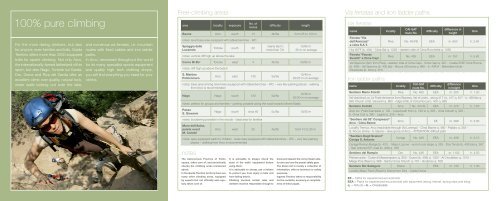
100% pure climbing<br />
For the more daring climbers, but also<br />
for anyone, even families and kids, Garda<br />
Trentino offers more than 2000 equipped<br />
trails for sports climbing. Not only Arco,<br />
the internationally-famed fatherland of this<br />
sport, but also Nago, Torbole sul Garda,<br />
Dro, Drena and Riva del Garda offer an<br />
excellent climb over quality, natural rock,<br />
sheer walls looking out over the lake,<br />
and numerous via ferratas, i.e. mountain<br />
routes with fixed cables and iron ladder<br />
paths.<br />
In Arco, renowned throughout the world<br />
for its many specialist sports equipment<br />
and quality high tech clothing shops,<br />
you will find everything you need for your<br />
climbs.<br />
Free-climbing areas<br />
area locality exposure<br />
notes<br />
The Autonomous Province of Trento<br />
equips, takes care of, and periodically<br />
checks the climbing areas mentioned<br />
above.<br />
In the Garda Trentino territory there are<br />
many other climbing areas, equipped<br />
by experts but not officially and regularly<br />
taken care of.<br />
It is advisable to always check the<br />
state of the walls’ equipment before<br />
using them.<br />
It is advisable to always use a helmet<br />
to protect you from injury in falls and<br />
from falling debris.<br />
No. of<br />
routes<br />
<strong>Climbing</strong> involves certain risks and<br />
climbers must be responsible enough to<br />
difficulty<br />
know and respect the correct basic safety<br />
rules and use the proper safety gear.<br />
The above list is merely a collection of<br />
information, with no technical or safety<br />
purposes.<br />
Ingarda Trentino takes no responsibility<br />
for the contents, accuracy or completeness<br />
of these pages.<br />
length<br />
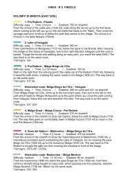
Baone Arco south 13 4b/6a from 25 to 100 m<br />
notes: level base area equipped with tables/benches - WC<br />
Spiaggia delle<br />
Lucertole<br />
Torbole south 20<br />
notes: vertical cliff high up above the lake<br />
mainly 6a/7c<br />
more than 7/b<br />
15/60 m<br />
30 m on average<br />
Corno Di Bo’ Torbole west 4 4b/5a 50/60 m<br />
notes: cliff high up above the beach<br />
S. Martino<br />
Policromuro<br />
Arco east 130 5a/9a<br />
15/40 m<br />
20/25 m on average<br />
notes: base area among olive trees equipped with tables/benches – WC – very few parking places - walking<br />
from Arco is recommended<br />
Nago Nago south 120 5a/8a<br />
notes: perfect for groups and families – parking possible along the road towards Monte Baldo<br />
Passo<br />
S. Giovanni<br />
15/40 m<br />
25/30 m on average<br />
Nago south circa 40 5c/8a 10/25 m<br />
notes: bouldering possible in the woods - ideal area for families<br />
Muro dell’Asino,<br />
parete ovest<br />
M. Colodri<br />
Arco west 35 4a/6b from 10 to 25 m<br />
notes: easy equipped walls for children - base area equipped with tables/benches – WC – very few parking<br />
places – walking from Arco is recommended<br />
Via ferratas and iron ladder paths<br />
Via ferratas<br />
name<br />
Ferrata “Via<br />
dell’Amicizia”<br />
a cima S.A.T.<br />
locality<br />
CAI-SAT<br />
route No.<br />
difficulty<br />
difference in<br />
height<br />
time<br />
Riva No. 404/B EEA m. 650 h. 2.40<br />
Hut W.FF (b. 404) - Cima Sat q. 1246 – eastern side of Cima Rocchetta q. 1250<br />
Ferrata “Fausto<br />
Susatti” a Cima Capi<br />
Riva No. 405 EEA m. 757 h. 5.40<br />
Val Sperone (3km from Riva) – eastern side of Cima Capi - Cima Capi q. 907 - Cresta S/SE Cima Rocca<br />
(b. 406) - Val Sperone (b. 405 bis) - Bocca d’Enzima q. 880 – b. 404/A - Belvedere Grola -<br />
Penstocks (b. 404) q. 373<br />
Iron ladder paths<br />
name<br />
locality<br />
CAI-SAT<br />
route No.<br />
difficulty<br />
difference<br />
in height<br />
Sentiero Mario Foletti Riva No. 460 EEA m. 205 h. 1.20<br />
Val Vasòtina/Loc Le Frate (entrance from Biacesa, Val di Ledro, along 417 ) b. 417 q. 617 - b. 460/bis q.<br />
840 Church of St. Giovanni q. 860 - ridge S/SE of Cima Rocca b. 405 q. 880<br />
Sentiero Colodri Arco No. 431/B EEA m. 270 h. 1.50<br />
Arco loc. Prabi/Campsite q. 100 – roped path from q. 190 to q. 325 - cima Colodri q. 325 -<br />
b. Cima Colt q. 360 - Laghel q. 220 – Arco<br />
“Sentiero del 92° Congresso”<br />
Arco - Cima Baone<br />
time<br />
Arco - EE m. 389 h. 3.00<br />
Locality Tremoz, Arco (reachable through Via Lomego) - Cima Baone q. 480 - Padaro q. 353 -<br />
S. Rocco shrine - b. Baone – olive grove of Arco – ATTENTION: difficult path<br />
“Sentiero Degli Scaloni”<br />
Ceniga S. Antonio<br />
Ceniga No. 428 EEA m. 408 h. 2.10<br />
Ceniga/Roman Bridge (b. 431) - Maso Lizzone - end of rock steps q. 325 - Dos Tondo (b. 428 bis) q. 507<br />
- San Antonio/S.P. road (b. 408) q. 766<br />
Sentiero del Rampin Dro No. 426 EEA m. 1102 h. 4.50<br />
Pietramurata - Coste di Massampiano q. 850 - Duson (b. 408) q. 1350 - Al Crocefisso q. 1215 -<br />
Malga Poia (Naon) q. 986 - Santa Croce Church q. 757 - Godenzo q. 558<br />
Sentiero Rio Sallagoni Drena - EEA m. 130 h. 1.30<br />
Locality Maso Trenti (Road to Drena from Dro) - Castle Drena<br />
EE = Paths for experienced excursionists<br />
EEA = Paths for experienced excursionists with equipment (string, helmet, spring-clips and sling)<br />
q. = Altitude – b. = Crossroads