UNITED ARAB EMIRATES
UNITED ARAB EMIRATES
UNITED ARAB EMIRATES

You also want an ePaper? Increase the reach of your titles
YUMPU automatically turns print PDFs into web optimized ePapers that Google loves.
DoD 2005.1-M<br />
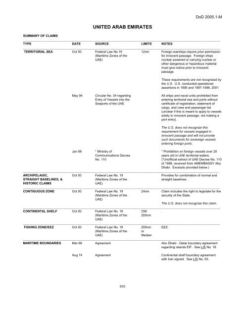
<strong>UNITED</strong> <strong>ARAB</strong> <strong>EMIRATES</strong><br />
SUMMARY OF CLAIMS<br />
_______________________________________________________________________________________________________________<br />
TYPE DATE SOURCE LIMITS NOTES<br />
_______________________________________________________________________________________________________________<br />
TERRITORIAL SEA Oct 93 Federal Law No.19<br />
(Maritime Zones of the<br />
UAE)<br />
12nm<br />
Foreign warships require prior permission<br />
for innocent passage. Foreign ships<br />
nuclear powered or carrying nuclear or<br />
other dangerous or hazardous material<br />
must give notice prior to innocent<br />
passage.<br />
These requirements are not recognized by<br />
the U.S. U.S. conducted operational<br />
assertions in 1995 and 1997-1998, 2001<br />
May 94<br />
Circular No. 34 regarding<br />
Entry of Vessels into the<br />
Seaports of the UAE<br />
All ships and naval units prohibited from<br />
entering territorial sea and ports without<br />
certificate of registration, statement of<br />
cargo, and crew and passenger list<br />
(unclear if this is meant to apply to vessels<br />
solely in innocent passage, not making a<br />
port entry).<br />
The U.S. does not recognize this<br />
requirement for vessels engaged in<br />
innocent passage and will not provide<br />
such documents for sovereign vessels<br />
entering foreign ports.<br />
Jan 98 * Ministry of<br />
Communications Decree<br />
No. 110<br />
* Prohibition on foreign vessels over 20<br />
years old in UAE territorial waters.<br />
(*Unofficial extract of UAE Decree No. 110<br />
of 1998, received from AMEMBASSY Abu<br />
Dhabi. Excerpts provided below.)<br />
______________________________________________________________________________________________________________<br />
ARCHIPELAGIC,<br />
STRAIGHT BASELINES, &<br />
HISTORIC CLAIMS<br />
Oct 93 Federal Law No. 19<br />
(Maritime Zones of the<br />
UAE)<br />
Provides for combination of normal and<br />
straight baselines.<br />
_______________________________________________________________________________________________________________<br />
CONTIGUOUS ZONE Oct 93 Federal Law No. 19<br />
(Maritime Zones of the<br />
UAE)<br />
24nm Claim includes the right to legislate for the<br />
security of the State.<br />
The U.S. does not recognize this claim.<br />
_______________________________________________________________________________________________________________<br />
CONTINENTAL SHELF Oct 93 Federal Law No. 19<br />
(Maritime Zones of the<br />
UAE)<br />
CM/<br />
200nm<br />
_______________________________________________________________________________________________________________<br />
FISHING ZONE/EEZ Oct 93 Federal Law No. 19<br />
200nm EEZ.<br />
(Maritime Zones of the<br />
UAE)<br />
or<br />
Median<br />
_______________________________________________________________________________________________________________<br />
MARITIME BOUNDARIES Mar 69 Agreement Abu Dhabi - Qatar boundary agreement<br />
regarding islands EIF. See LIS No. 18.<br />
Aug 74 Agreement Continental shelf boundary agreement<br />
with Iran signed. See LIS No. 63.<br />
.<br />
633
DoD 2005.1-M<br />
_______________________________________________________________________________________________________________<br />
TYPE DATE SOURCE LIMITS NOTES<br />
_______________________________________________________________________________________________________________<br />
MARITIME BOUNDARIES,<br />
Continued<br />
Oct 81 Arbitral Award Dubai - Sharjah territorial sea and<br />
continental shelf boundaries determined.<br />
_______________________________________________________________________________________________________________<br />
LOS CONVENTION Dec 82 Signed Convention; never ratified.<br />
_______________________________________________________________________________________________________________<br />
LEGISLATION<br />
The following is extracted from Ministry Of Communications Decree No. 110 Of 1998.<br />
Article 4<br />
1) Foreign vessels registered in the UAE cannot operate in UAE territorial waters unless they carry a valid navigation license issued by the<br />
Administration Department. The Administration Department issues the license by request of the vessel owner or his shipping agent in the<br />
UAE. The vessel owner or his shipping agent has to submit all necessary documents and certificates required by the Administration<br />
Department at the time of registration.<br />
Article 10<br />
Foreign vessels that are more than twenty years old, from the date of construction, are not allowed to operate in UAE territorial waters. The<br />
ministry of transportation holds the right to ban such vessels from operating.<br />
Article 12<br />
Both national and foreign vessels must have a genral and valid insurance policy to classify for operation in UAE territorial waters. The<br />
insurance policy must cover third party liabilities.<br />
Article 13<br />
All vessels that operate in UAE territorial waters must have a certification stating the minimum number of crew. The certificate must further<br />
specify labor categories and the number of staff of each category. Moreover, the certificate must be shown upon request, in accordance<br />
with rules stated in the international maritime convention that the UAE has signed.<br />
Article 14<br />
National and foreign vessels must not carry or store hazardous good, including crude oil and its derivatives, excluding vessels that are<br />
constructed and licensed fro this use. The concerned authorities will take necessary judicial measures and confiscate vessels that do not<br />
comply with these rules.<br />
MARITIME BOUNDARY AGREEMENTS<br />
UAE (DUBAI) - IRAN<br />
The following is extracted from the Continental Shelf Boundary Agreement between Dubai and Iran, signed August 1974.<br />
Article 1<br />
The boundary line dividing the continental shelf lying between the territory of U.A.E. on the one side and that of Iran on the other side, except<br />
in the vicinity of Sirri Island, shall consist of geodetic lines between the following points:<br />
TABLE C1.T267.<br />
UAE (DUBAI) - IRAN CONTINENTAL SHELF COORDINATES<br />
UAE (DUBAI) - IRAN CONTINENTAL SHELF COORDINATES<br />
POINT LATITUDE NORTH LONGITUDE EAST COMMENTS<br />
1 25° 38' 13" 54° 05' 16"<br />
2 25° 39' 55" 54° 26' 18"<br />
3 25° 41' 35" 54° 30' 25" from this point the boundary line coincides with the southern<br />
12-mile limit of the territorial waters of the Sirri Island to:<br />
4 25° 47' 20" 54° 44' 50"<br />
634
DoD 2005.1-M<br />
UAE (DUBAI) - IRAN CONTINENTAL SHELF COORDINATES<br />
POINT LATITUDE NORTH LONGITUDE EAST COMMENTS<br />
5 25° 47' 30" 54° 45' 07"<br />
UAE (ABU DHABI) - QATAR<br />
The following is extracted from the Agreement between Abu Dhabi and Qatar on the Settlement of Maritime Boundary Lines and Sovereign<br />
Rights over Islands (Qatar v. Bahrain), signed and EIF 20 March 1969.<br />
Recognizing the cordial and fraternal relations that exist between the two sister Arab States, and desirous of settling maritime boundary lines<br />
and sovereign rights over islands on the basis of their mutual interests, the two Contracting Parties have agreed as follows:<br />
(1) That 'Dina' Island is part of the territory of Abu Dhabi;<br />
(2) That the islands of 'Lashat' and 'Shraho' are part of the territory of Qatar;<br />
(3) That both States will have no further national claims against each other in islands and waters beyond the maritime boundary lines herein<br />
agreed to.<br />
(4) That the maritime boundary lines referred to in paragraph (3) above are as follows:<br />
(a) A straight line between Point A at:<br />
TABLE C1.T268.<br />
UAE (ABU DHABI) - QATAR MARITIME BOUNDARY COORDINATES<br />
LATITUDE LONGITUDE COMMENT<br />
25° 31' 50" 53° 02' 05" and point B, 'Bir Elbundug', at:<br />
25° 05' 54.79" 53° 36' 50.98"<br />
(b) A straight line between point B (described above), and point C, at:<br />
CONTINUATION OF TABLE C1.T268.<br />
LATITUDE<br />
LONGITUDE<br />
24° 48' 40" 52° 16' 20"<br />
(c) A straight line from point C (described above) to point D (at Bab Khor Eladid at the territorial sea boundary) at:<br />
CONTINUATION OF TABLE C1.T268.<br />
LATITUDE<br />
LONGITUDE<br />
24° 48' 40" 52° 16' 20"<br />
(6) That the Contracting Parties will have equal rights of ownership over 'Hagl Elbundug' and agreed to consult each other in all matters<br />
concerning its exploitation.<br />
635