nAVIonICS pLAtInuM+ XL3 AMERICAS 900P+ WESt GrEAt lAkES MICHIGAN, SUPERIOR, HURON Including Lake of the Woods, Rainy Lake, North Channel, Georgian Bay, Green Bay and Lake Winnebago. 901P+ EASt GrEAt lAkES ONTARIO, ERIE and ST CLAIR, HURON, OTTAWA RIVER Including North Channel, Georgian Bay, Trent Severn Waterway, Rideau Waterway, The Finger Lakes and Lake Champlain. 902P-2 NS-St lAWrENCE rIVEr ST LAWRENCE RIVER, GULF OF ST LAWRENCE, NOVA SCOTIA, LAKE CHAMPLAIN From Cornwall and Montebello to Bay of Fundy, including Sable Island, Iles De La Madeleine, Prince Edward Island, Anticosti Island and Lake George. 903P-2 NS-NEWFoUNDlAND GULF OF ST. LAWRENCE, NEWFOUNDLAND Including Cape Breton Island, Iles De La Madeleine, Prince Edward Island and Strait of Belle Isle. 904P+ US NE & CANYoNS MAINE, MASSACHUSETTS, NEW YORK, HUDSON RIVER, NORTH ATLANTIC CANYONS From Passamaquoddy Bay and Grand Manan Island to Shark River Inlet, including Hudson River to New York State Barge Canal to Lake Ontario, Oneida Lake, The Finger Lakes, Lake Champlain and bathymetric details of all North Atlantic Canyons from Delaware Bay offshore to Georges Bank and East to 64° West. 905P+ US mID AtlAN & CYNS NEW JERSEY, DELAWARE BAY, CHESAPEAKE BAY, NORTH CAROLINA - From New York Harbor to Cape Romain, including Philadelphia, Norfolk and bathymetric details of all Mid-Atlantic Canyons. 906P+ US-SE & N BAhAmAS SOUTH CAROLINA, FLORIDA, BAHAMAS NORTH - From Cape Fear to Long Island to Cedar Keys, including the entire Florida Keys, Dry Tortugas and Cay Sal Bank. 907P+ GUlF oF mEXICo EAST, CENTRAL AND WEST GULF OF MEXICO From Venice, FL to Brownsville, TX. 908P-2 CArIBBEAN & BAhAmAS CUBA, HAITI, JAMAICA, DOMINICAN REPUBLIC, GRENADA, NORTH COLOMBIA, GUYANA, BAHAMAS, SOUTH FLORIDA, BERMUDA - From Fort Pierce to Fort Myers in Florida Including the Cayman Islands, Puerto Rico, Lesser Antilles, Windward Islands, Boca Grande, Trinidad, Golfo de Uraba, Aruba and Curacao. 909P-2 SoUth AmErICA EASt SOUTH AMERICA NORTHEAST, CENTRAL BRAZIL, SOUTH BRAZIL, ARGENTINA From Trinidad and Tobago to Cape Horn to Isla Hanover, including Ilhas Martin Vaz, Ilha da Trindade, Atol das Rocas, Arquipelago de Fernando de Noronha, Golfo San Matias, Golfo San Jorge, Bahia Grande, Strait of Magellan, Falkland islands, South Georgia. 910P+ SoUth AmErICA WESt SOUTH AMERICA NORTHWEST, SOUTHWEST, SOUTHEAST From Panama to Cape Horn to Bahia Blanca including Archipielago de Colon, Strait of Magellan, Falkland Islands and Cape Disappointment. 911P-2 CENtrAl AmErICA CENTRAL AMERICA WEST, CENTRAL AMERICA EAST, BAJA CALIFORNIA TO VENEZUELA From Point Arena, California to Colombia/Ecuador border and through Panama Canal East to Bahia de Danta Marta and northwest to Brownsville, TX. 912P+ US WESt CoASt-hAWAII PUGET SOUND, WASHINGTON, OREGON, CALIFORNIA, BAJA, HAWAII From Vancouver, BC to Cabo San Lucas, MX, Cape Flattery and offshore bathymetric data and the entire chain of the Hawaiin Islands. 913P+ VANCoUVEr ISlAND PUGET SOUND, BRITISH COLUMBIA, VANCOUVER ISLAND From Puget Sound to Queen Charlotte Sound, including Juan de Fuca Strait, Strait of Georgia, Johnstone Strait, Queen Charlotte Strait, Cape Flattery. 914P-2 North BC-BArANoF ISlAND Hecate Strait, Queen Charlotte Island, Chatham Sound, Gambier Bay, Parry Passage, Neva Strait. From Queen Charlotte Sound to Frederick Sound, including Prince of Wales Island, Kuiu Island, Chatham Strait and Baranof Island. 915P-2 SoUth AlASkA South Central Alaska, Alaska Peninsula, Wrangell Narrows, Skagway. From Frederick Sound to Unimak Island, including Cook Inlet and Prince William Sound. 916P-2 NW AlASkA-AlEUtIANS Aleutian Islands, Western Alaska, Northern Alaska, From Shumagin Islands to Demarcation Bay, including Dutch Harbor and the Pribilof Islands. navionics.com 14
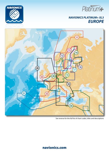
nAVIonICS pLAtInuM+ XL3 EuRopE 11 12 13 14 28 17 16 25 26 15 33 31 32 34 See reverse for the full list of chart codes, titles and descriptions 43 navionics.com 15