Streams - Kitsap County Government
Streams - Kitsap County Government
Streams - Kitsap County Government

Create successful ePaper yourself
Turn your PDF publications into a flip-book with our unique Google optimized e-Paper software.
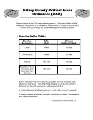
Buffers and Building<br />
Setbacks<br />
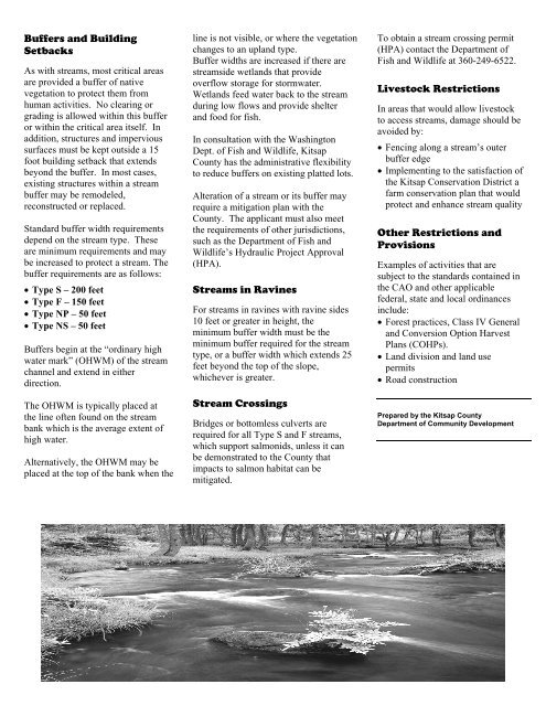
As with streams, most critical areas<br />
are provided a buffer of native<br />
vegetation to protect them from<br />
human activities. No clearing or<br />
grading is allowed within this buffer<br />
or within the critical area itself. In<br />
addition, structures and impervious<br />
surfaces must be kept outside a 15<br />
foot building setback that extends<br />
beyond the buffer. In most cases,<br />
existing structures within a stream<br />
buffer may be remodeled,<br />
reconstructed or replaced.<br />
Standard buffer width requirements<br />
depend on the stream type. These<br />
are minimum requirements and may<br />
be increased to protect a stream. The<br />
buffer requirements are as follows:<br />
• Type S – 200 feet<br />
• Type F – 150 feet<br />
• Type NP – 50 feet<br />
• Type NS – 50 feet<br />
Buffers begin at the “ordinary high<br />
water mark” (OHWM) of the stream<br />
channel and extend in either<br />
direction.<br />
The OHWM is typically placed at<br />
the line often found on the stream<br />
bank which is the average extent of<br />
high water.<br />
Alternatively, the OHWM may be<br />
placed at the top of the bank when the<br />
line is not visible, or where the vegetation<br />
changes to an upland type.<br />
Buffer widths are increased if there are<br />
streamside wetlands that provide<br />
overflow storage for stormwater.<br />
Wetlands feed water back to the stream<br />
during low flows and provide shelter<br />
and food for fish.<br />
In consultation with the Washington<br />
Dept. of Fish and Wildlife, <strong>Kitsap</strong><br />
<strong>County</strong> has the administrative flexibility<br />
to reduce buffers on existing platted lots.<br />
Alteration of a stream or its buffer may<br />
require a mitigation plan with the<br />
<strong>County</strong>. The applicant must also meet<br />
the requirements of other jurisdictions,<br />
such as the Department of Fish and<br />
Wildlife’s Hydraulic Project Approval<br />
(HPA).<br />
<strong>Streams</strong> in Ravines<br />
For streams in ravines with ravine sides<br />
10 feet or greater in height, the<br />
minimum buffer width must be the<br />
minimum buffer required for the stream<br />
type, or a buffer width which extends 25<br />
feet beyond the top of the slope,<br />
whichever is greater.<br />
Stream Crossings<br />
Bridges or bottomless culverts are<br />
required for all Type S and F streams,<br />
which support salmonids, unless it can<br />
be demonstrated to the <strong>County</strong> that<br />
impacts to salmon habitat can be<br />
mitigated.<br />
To obtain a stream crossing permit<br />
(HPA) contact the Department of<br />
Fish and Wildlife at 360-249-6522.<br />
Livestock Restrictions<br />
In areas that would allow livestock<br />
to access streams, damage should be<br />
avoided by:<br />
• Fencing along a stream’s outer<br />
buffer edge<br />
• Implementing to the satisfaction of<br />
the <strong>Kitsap</strong> Conservation District a<br />
farm conservation plan that would<br />
protect and enhance stream quality<br />
Other Restrictions and<br />
Provisions<br />
Examples of activities that are<br />
subject to the standards contained in<br />
the CAO and other applicable<br />
federal, state and local ordinances<br />
include:<br />
• Forest practices, Class IV General<br />
and Conversion Option Harvest<br />
Plans (COHPs).<br />
• Land division and land use<br />
permits<br />
• Road construction<br />
Prepared by the <strong>Kitsap</strong> <strong>County</strong><br />
Department of Community Development