Property Conveyance Record Drawing Instructions - Kitsap Public ...
Property Conveyance Record Drawing Instructions - Kitsap Public ...
Property Conveyance Record Drawing Instructions - Kitsap Public ...

You also want an ePaper? Increase the reach of your titles
YUMPU automatically turns print PDFs into web optimized ePapers that Google loves.
SCOTT W. LINDQUIST, MD, MPH, DIRECTOR<br />
345 6TH STREET, 345 6th Street, SUITE Suite 300 300<br />
BREMERTON, Bremerton, WA 98337-1866 WA 98337-1866<br />
(360) (360) 337-5235 337-5235<br />
FAX (360) 337-5291<br />
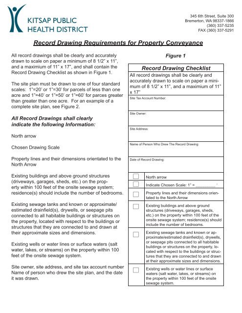
<strong>Record</strong> <strong>Drawing</strong> Requirements for <strong>Property</strong> <strong>Conveyance</strong><br />
All record drawings shall be clearly and accurately<br />
drawn to scale on paper a minimum of 8 1/2” x 11”,<br />
and a maximium of 11” x 17”, and shall contain the<br />
<strong>Record</strong> <strong>Drawing</strong> Checklist as shown in Figure 1.<br />
The site plan must be drawn to one of four standard<br />
scales: 1”=20’ or 1”=30’ for parcels of less than one<br />
acre and 1”=40’ or 1”=50’ or 1”=60’ for parces greater<br />
than greater than one acre. For an example of a<br />
complete site plan, see Figure 2.<br />
All <strong>Record</strong> <strong>Drawing</strong>s shall clearly<br />
indicate the following Information:<br />
North arrow<br />
Chosen <strong>Drawing</strong> Scale<br />
<strong>Property</strong> lines and their dimensions orientated to the<br />
North Arrow<br />
Existing buildings and above ground structures<br />
(driveways, garages, sheds, etc.) on the property<br />
within 100 feet of the onsite sewage system;<br />
residence(s) should include the number of bedrooms.<br />
Existing sewage tanks and known or approximate/<br />
estimated drainfield(s), drywells, or seepage pits<br />
connected to all habitable buildings or structures on<br />
the property, located with respect to the buildings or<br />
structures that they are connected to and drawn at<br />
their approximate sizes and dimensions.<br />
Existing wells or water lines or surface waters (salt<br />
water, lakes, or streams) on the property within 100<br />
feet of the onsite sewage system.<br />
Site owner, site address, and site tax account number<br />
Name of person who drew the site plan, and the date<br />
it was drawn.<br />
<strong>Record</strong> <strong>Drawing</strong> Checklist<br />
All record drawings shall be clearly and<br />
accurately drawn to scale on paper a minimum<br />
of 8 1/2” x 11”, and a maximium of 11”<br />
x 17”<br />
Site Tax Account Number:<br />
Site Owner:<br />
Site Address:<br />
Name of Person Who Drew The <strong>Record</strong> <strong>Drawing</strong>:<br />
Date of <strong>Record</strong> <strong>Drawing</strong>:<br />
North arrow<br />
Figure 1<br />
Indicate Chosen Scale: 1” = _________ ‘<br />
<strong>Property</strong> lines and their dimensions orientated<br />
to the North Arrow<br />
Existing buildings and above ground<br />
structures (driveways, garages, sheds,<br />
etc.) on the property within 100 feet of the<br />
onsite sewage system; residence(s) should<br />
include the number of bedrooms.<br />
Existing sewage tanks and known or approximate/estimated<br />
drainfield(s), drywells,<br />
or seepage pits connected to all habitable<br />
buildings or structures on the property, located<br />
with respect to the buildings or structures<br />
that they are connected to and drawn<br />
at their approximate sizes and dimensions.<br />
Existing wells or water lines or surface<br />
waters (salt water, lakes, or streams) on<br />
the property within 100 feet of the onsite<br />
sewage system.
Figure 2<br />
Surface Water<br />
150’<br />
<strong>Record</strong> <strong>Drawing</strong> Checklist<br />
All record drawings shall be clearly and<br />
accurately drawn to scale on paper a minimum<br />
of 8 1/2” x 11”, and a maximium of 11”<br />
x 17”<br />
Site Tax Account Number:<br />
12345678910123<br />
>100’ to surface water<br />
North<br />
Site Owner:<br />
Site Address:<br />
John & Jane Doe<br />
183 Street Ave., Poulsbo<br />
Name of Person Who Drew The <strong>Record</strong> <strong>Drawing</strong>:<br />
John Doe<br />
Date of <strong>Record</strong> <strong>Drawing</strong>:<br />
December 25th, 2007<br />
60’<br />
North arrow<br />
Indicate Chosen Scale: 1” = _________ ‘<br />
30<br />
210’<br />
30’<br />
7’<br />
Approximate<br />
Drainfield Area<br />
Septic Tank<br />
30’<br />
Shed<br />
<strong>Property</strong> lines and their dimensions orientated<br />
to the North Arrow<br />
Existing buildings and above ground<br />
structures (driveways, garages, sheds,<br />
etc.) on the property within 100 feet of the<br />
onsite sewage system; residence(s) should<br />
include the number of bedrooms.<br />
Existing sewage tanks and known or approximate/estimated<br />
drainfield(s), drywells,<br />
or seepage pits connected to all habitable<br />
buildings or structures on the property,<br />
located with respect to the buildings or<br />
structures that they are connected to and<br />
drawn at their approximate sizes and<br />
dimensions.<br />
15’<br />
3 bedroom home<br />
Existing wells or water lines or surface<br />
waters (salt water, lakes, or streams) on<br />
the property within 100 feet of the onsite<br />
sewage system.<br />
30’<br />
Water Line<br />
Street Ave.