Download Marina Handbook - Carrickfergus Borough Council
Download Marina Handbook - Carrickfergus Borough Council
Download Marina Handbook - Carrickfergus Borough Council

You also want an ePaper? Increase the reach of your titles
YUMPU automatically turns print PDFs into web optimized ePapers that Google loves.
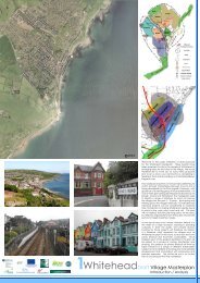
Sailing Directions<br />
<strong>Carrickfergus</strong> Harbour<br />
LAT: 54° 42’. 63 N<br />
LONG: 5° 48’. 30 W<br />
<strong>Carrickfergus</strong> Harbour HW as Dover, Rise<br />
2.9m (9’6”) SP: 1.8m (6’) NP: is situated on<br />
the Northern shore of Belfast Lough to the<br />
west of <strong>Carrickfergus</strong> Castle.<br />
The Marine Services facilities are located<br />
on the southern end of the west pier as is a<br />
purpose-built <strong>Marina</strong> basin accommodating<br />
10 boats in pontoon berths behind rubble<br />
stone breakwaters. This basin is partly<br />
dredged to give depths of up to 2.9 metres<br />
(9’6”) at L.W.S. <strong>Carrickfergus</strong> Harbour also<br />
has an inner harbour area accommodating<br />
up to 36 boats and a public slipway that is<br />
accessible 2 hours either side of high water.<br />
The entrance to the Harbour is open to the<br />
South and is dredged to 2.3 metres (7’6”)<br />
at L.W.S. The ends of the east and west<br />
piers are marked with red and green<br />
beacons showing Fl. G 7.5s 5m 4M<br />
and R 7.5s 5m 4M.<br />
Navigational marks are located within<br />
the Harbour defining the approach to the<br />
harbour basin. Pass between two navigation<br />
perches marking the toe of the internal<br />
breakwater and revetment. Turn to port to<br />
approach pontoons and marine services<br />
site leaving the second breakwater perch to<br />
port. Note presence of isolated tubular piles<br />
in central harbour area. Leave these piles<br />
to port on approach to harbour slipway and<br />
inner harbour berths.<br />
18