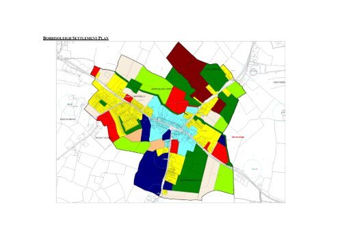
borrisoleigh settlement plan - North Tipperary County Council
borrisoleigh settlement plan - North Tipperary County Council
borrisoleigh settlement plan - North Tipperary County Council

You also want an ePaper? Increase the reach of your titles
YUMPU automatically turns print PDFs into web optimized ePapers that Google loves.
BORRISOLEIGH SETTLEMENT PLAN
1.0 General Introduction and<br />
Development Context<br />
• Location<br />
Borrisoleigh is situated on the R-498<br />
between Thurles and Nenagh and is<br />
intersected on the northern side of the town<br />
by the Clodagh River.<br />
• Population<br />
The population of the town grew between<br />
1996 and 2002 from 564 persons to 598<br />
persons, which is a 6% increase in<br />
population in the period and this rose to 626<br />
in 2006 CSO figures, a further increase of<br />
4.7%.<br />
• Settlement Form<br />
The town is situated in a high quality<br />
landscape area, lying in a bowl-shaped<br />
syncline north east of the Silvermines and<br />
Slievefelim Mountains. The town itself rises<br />
towards the north and south, with important<br />
buildings, such as the renaissance Catholic<br />
Church, located in prominent positions.<br />
The town centre has a linear pattern with<br />
junctions with Pallas Street and Chapel<br />
Street. The church dominates the central<br />
area with some good examples of Irish<br />
Victorian architecture in Finn’s pub and<br />
Chadwick’s shop. The town is the home of<br />
<strong>Tipperary</strong> Natural Mineral Water which is a<br />
nationally and internationally recognised<br />
brand and is a large employer in the town<br />
and occupies a significant area.<br />
2.0 Key aim and objectives<br />
Borrisoleigh has been identified as being a<br />
Secondary Service Areas / Market Town in<br />
Chapter 3 of the <strong>County</strong> Development Plan.<br />
The key aim of this <strong>settlement</strong> <strong>plan</strong> is to<br />
provide a framework for the development<br />
for appropriate residential, commercial and<br />
industrial development, to enhance the<br />
visual character and amenities of the town<br />
and to ensure that Borrisoleigh provides the<br />
services and facilities for its hinterland.<br />
Key Objectives<br />
• To facilitate low density, high<br />
quality housing appropriate to the<br />
town and its designation as a<br />
Secondary Service Areas / Market<br />
Town on the Settlement Hierarchy<br />
in Chapter 3 of the Plan.<br />
• To maintain and enhance social,<br />
community and amenity facilities<br />
within the town.<br />
• To support opportunities for<br />
commercial, industrial and other<br />
employment facilities.<br />
• To focus development within the<br />
development boundary of the<br />
<strong>settlement</strong>.<br />
3.0 Services and Social Infrastructure<br />
• Water Supply<br />
The <strong>settlement</strong> is serviced by a public water<br />
supply.<br />
• Waste Water<br />
The <strong>settlement</strong> is serviced by a waste water<br />
treatment <strong>plan</strong>t and public sewer. Upgrade<br />
works may be required during the lifetime of<br />
the Plan. Notwithstanding that the amount<br />
of land zoned in the <strong>plan</strong> allows for growth<br />
in the town, normal <strong>plan</strong>ning development<br />
management practice is that proposals are<br />
assessed as regards capacity of services to<br />
cater for them and development would not<br />
be permitted unless adequate treatment can<br />
be assured. Any development proposed
within the town will need to clearly<br />
demonstrate this as part of any <strong>plan</strong>ning<br />
application.<br />
• Roads and Transport<br />
Infrastructure<br />
Borrisoleigh is situated on the R498 and<br />
R501, conveniently located in relation to the<br />
major towns of Thurles, Nenagh and the<br />
City of Limerick.<br />
There is an extensive network of footpaths<br />
within the area. Public lighting is provided<br />
throughout the <strong>settlement</strong>.<br />
church in McDonagh Square. The window<br />
and door surrounds were quarried at<br />
Drombane, 12 miles away. It is similar to<br />
the stone used in Cormacs Chapel, Cashel.<br />
Conservation Area<br />
This includes all of Main Street, northern<br />
part of Pallas Street, part of Chapel Street<br />
and Lower Street.<br />
Protected Structures<br />
See RPS for list of Protected Structures in<br />
the <strong>County</strong> Development Plan 2010-2016 as<br />
set out in the main text in Volume III.<br />
5.0 Key Messages for Borrisoleigh<br />
• Social and Community<br />
Infrastructure<br />
A Roman Catholic Church, primary and<br />
secondary schools, Town Park with GAA<br />
pitch, soccer pitch, tennis courts pavilion<br />
and play ground, public houses, shops,<br />
butchers, hairdressers, chemists,<br />
guesthouses, take-away, bank, bakery,<br />
restaurant and a post office are currently<br />
located within the <strong>settlement</strong> providing for<br />
the immediate needs of those living within<br />
the hinterland of the town.<br />
4.0 Architectural and Archaeological<br />
Heritage<br />
There are a number of significant historical<br />
sites within the town. Among its attractions<br />
are some traditional shop fronts, and a 15th<br />
century tower house. An inscribed slab<br />
inserted into the gable of one of a pair of red<br />
sandstone houses are engraved the names<br />
Richard Burke and Ellis Hurley, 1643.<br />
Walter Doolin was the architect of the<br />
• The <strong>settlement</strong> shall be developed in<br />
a properly <strong>plan</strong>ned and coherent<br />
manner. The picturesque setting<br />
shall be retained and enhanced in<br />
accordance with appropriately<br />
designed and sensitive development.<br />
• The conservation and integration<br />
into new development of existing<br />
stone walls, trees and native<br />
hedgerows, and promotion of<br />
similar materials for new<br />
boundaries.<br />
• High quality designs, which are<br />
particularly reflective of the<br />
predominantly rural character of the<br />
area, without precluding high<br />
quality innovative contemporary<br />
designs.<br />
• Promotion of natural building and<br />
boundary materials.<br />
• The conservation and protection of<br />
protected structures, recorded<br />
monuments and other features of
archaeological and historical merit<br />
within the <strong>settlement</strong>.<br />
6.0 General Development Objectives<br />
Proposals for development will be assessed<br />
in accordance with the policies and<br />
objectives of the <strong>County</strong> Development Plan<br />
2010-2016 as set out in the main text in<br />
Volume I.<br />
In addition to general policy requirements<br />
for development, the <strong>Council</strong> will seek to<br />
implement the following objectives:<br />
• Facilitate people to live in high<br />
quality, primarily low density<br />
housing in a rural town location.<br />
• Maintain services at a local level.<br />
• Reinforce the attractive rural town<br />
which exists at present by<br />
permitting appropriate and<br />
sensitively designed new<br />
development.<br />
• Facilitate the creation of retail,<br />
commercial, industrial and other<br />
employment opportunities.<br />
• The rate of growth must be in<br />
accordance with the <strong>Council</strong>’s<br />
policy on towns and villages and the<br />
availability of services (including<br />
physical and social provisions).<br />
3. To protect existing access to backlands<br />
and to support the redevelopment of Main<br />
Street properties as part of the development<br />
of backlands. Such lands include lands south<br />
of Main Street, to the rear of Old School and<br />
<strong>Council</strong> Car Park and lands south of Main<br />
Street to the rear of Garda Station.<br />
4. To provide suitable and accessible land<br />
for commercial development. A prominent<br />
site is zoned on the Thurles Road, south of<br />
the Sewerage Treatment Plant, for such use<br />
to attract uses that heretofore have been<br />
developed in rural locations along the R-<br />
498.<br />
5. To preserve the Local Road L-3215 to<br />
the north of the town free from sporadic<br />
development and/or development that would<br />
have a negative impact on the setting of the<br />
town.<br />
6. To seek to implement a town<br />
improvement scheme which would include<br />
the under-grounding of cables and wirescape<br />
within the town, the improvement of<br />
pavement quality and the introduction of<br />
landscaping into the town where possible.<br />
7. To seek to provide traffic calming on<br />
approach roads into the town where<br />
resources permit.<br />
8. To seek to improvement junctions within<br />
the town as resources permit.<br />
9. To seek that the proposed linear park<br />
along the river provides adequate pedestrian<br />
walkways and access to the river where<br />
possible.<br />
10. To seek the provision of an amenity area in<br />
Borrisland <strong>North</strong> to be developed as part of new<br />
developments with seating/picnic area/play<br />
area/skate board park etc.<br />
Specific Objectives<br />
1. To create an Inner Relief Road as part of<br />
future development to link the R498 on the<br />
western side of the town with the<br />
Templemore Road (R501).<br />
2. To seek the restoration of a number of<br />
derelict or vacant sites in the town.