A Comparison of Seafloor Classification Methods Through the Use ...
A Comparison of Seafloor Classification Methods Through the Use ...
A Comparison of Seafloor Classification Methods Through the Use ...

You also want an ePaper? Increase the reach of your titles
YUMPU automatically turns print PDFs into web optimized ePapers that Google loves.
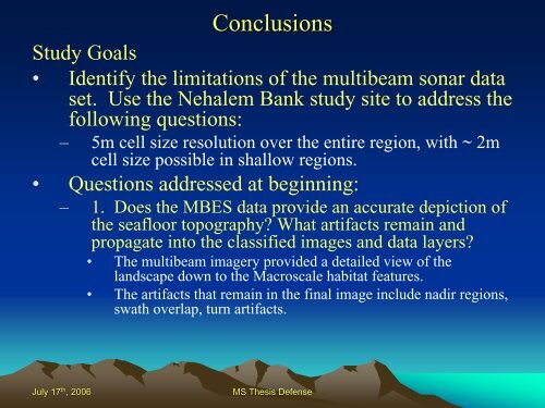
Conclusions<br />
Study Goals<br />
• Identify <strong>the</strong> limitations <strong>of</strong> <strong>the</strong> multibeam sonar data<br />
set. <strong>Use</strong> <strong>the</strong> Nehalem Bank study site to address <strong>the</strong><br />
following questions:<br />
– 5m cell size resolution over <strong>the</strong> entire region, with ~ 2m<br />
cell size possible in shallow regions.<br />
• Questions addressed at beginning:<br />
– 1. Does <strong>the</strong> MBES data provide an accurate depiction <strong>of</strong><br />
<strong>the</strong> seafloor topography? What artifacts remain and<br />
propagate into <strong>the</strong> classified images and data layers?<br />
• The multibeam imagery provided a detailed view <strong>of</strong> <strong>the</strong><br />
landscape down to <strong>the</strong> Macroscale habitat features.<br />
• The artifacts that remain in <strong>the</strong> final image include nadir regions,<br />
swath overlap, turn artifacts.<br />
July 17 th , 2006 MS Thesis Defense