Nationwide Differential GPS System - GPS.gov
Nationwide Differential GPS System - GPS.gov
Nationwide Differential GPS System - GPS.gov

Create successful ePaper yourself
Turn your PDF publications into a flip-book with our unique Google optimized e-Paper software.
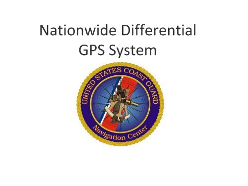
<strong>Nationwide</strong> <strong>Differential</strong><br />
<strong>GPS</strong> <strong>System</strong>
Presentation Overview<br />
•NAVCEN Organizational Summary.<br />
•<strong>Nationwide</strong> <strong>Differential</strong> <strong>GPS</strong> (D<strong>GPS</strong>) Overview.<br />
•Dept. of Transportation (DOT) Inland D<strong>GPS</strong><br />
coverage/site status.<br />
•D<strong>GPS</strong> Equipment Upgrades.<br />
•D<strong>GPS</strong> Partnerships<br />
•Summary
Command Overview<br />
Commanding Officer<br />
CAPT Frank Parker<br />
Administrative Assistant<br />
Ms. Denise Bernard‐Moore<br />
Executive Officer<br />
CDR Marc Sanders<br />
Command Master Chief<br />
CMC Neil Orthober<br />
Command<br />
Duty Officer<br />
Operations Division<br />
CDR Randall Navarro<br />
NIS Watch, D<strong>GPS</strong>/ND<strong>GPS</strong> Watch,<br />
IRVMC Watch, NAIS Watch, LRIT<br />
Watch, DIMEO, INFO Services<br />
<strong>System</strong>s Support Division<br />
Mr. Gene Schlechte<br />
<strong>System</strong> Support for <strong>GPS</strong>, D<strong>GPS</strong>,<br />
ND<strong>GPS</strong>, LORAN, IRVMC, NAIS, LRIT,<br />
and Waterways <strong>System</strong>s Analysis<br />
Strategic Planning & Support<br />
Division<br />
LT Luke Byrd<br />
Administrative Assistance, HR, QA,<br />
Planning, Financial Management,<br />
Inventory Control, Supply and<br />
Procurement<br />
MIOC<br />
Alexandria, VA<br />
NAVCEN Liaison<br />
at the<br />
<strong>GPS</strong>OC Schriever, AFB<br />
(OSC Billet)
Maritime Information Operations Center<br />
24/7 Operation of the following:<br />
• Web based Information<br />
Services.<br />
• Navigation Information Service.<br />
• <strong>GPS</strong> Civil Interface.<br />
• D<strong>GPS</strong> Monitor & Control.<br />
• Inland River Vessel Movement<br />
Center.<br />
• <strong>Nationwide</strong> Automatic<br />
Information <strong>System</strong>.
<strong>Nationwide</strong> <strong>Differential</strong> <strong>GPS</strong><br />
• Satisfies Harbor Entrance & Approach, Inland Waterways & Terrestrial<br />
Requirements<br />
• 50 Maritime Broadcast Sites, 9 U.S. Army Corps of Engineer Sites, 29<br />
<strong>Nationwide</strong> D<strong>GPS</strong> Sites, 2 Control Centers.<br />
• Maritime D<strong>GPS</strong> <strong>System</strong> achieved Full Operational Capability (FOC) on 15<br />
March 1999.<br />
• <strong>Nationwide</strong> D<strong>GPS</strong> <strong>System</strong> is currently working towards Initial Operational<br />
Capability (IOC). Seven sites remain to be constructed to achieve single<br />
coverage of 99% of the continental United States.<br />
• Partnership agencies: USCG, DOT (RITA), NOAA/NGS, USACE
Typical D<strong>GPS</strong> Site Layout<br />
<strong>GPS</strong><br />
Reference<br />
Antenna<br />
Equipment Hut<br />
Transmitting<br />
Antenna<br />
<strong>GPS</strong> Reference Antenna
ND<strong>GPS</strong> Site Locations
ND<strong>GPS</strong> Signal Coverage
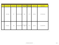
DOT D<strong>GPS</strong> Single Coverage Goal<br />
• Initial Operational Capability (IOC) goal is 99% of continental United States<br />
with single coverage.<br />
• 7 sites are needed to achieve IOC.<br />
• Site Name: Bliss Location: Bliss, Idaho<br />
• Site Name: Tucson Location: Tucson, Arizona<br />
• Site Name: Carlsbad Location: Carlsbad, New Mexico<br />
• Site Name: Sage Junction Location: Sage Junction, Idaho<br />
• Site Name: Marshall Location: Marshall, Texas<br />
• Site Name: Big Lake Location: Big Lake, Texas<br />
• Site Name: Patten Location: Patten, Maine<br />
• All advance preparation work has been either completed or is near<br />
completion for the remaining 7 sites.<br />
• Funding is pending.
DOT Inland Coverage IOC Objective
D<strong>GPS</strong> Recap/Upgrades<br />
• FC‐20<br />
– FC‐20: Upgraded Receivers & Antennas:<br />
L1/L2 (L2C) Geodetic Grade<br />
• EC‐03<br />
– COTS equipment.<br />
– Accuracy is observed to be 1‐3 meters<br />
– New system architecture is easier and less<br />
expensive to upgrade as new technologies<br />
become available.<br />
– Ethernet based with remote capability.<br />
• NAUTEL Transmitter Replacement<br />
– Southern Avionics Company (SAC)<br />
transmitters replaced with new modular<br />
NAUTEL Vector D transmitters.<br />
– USCG Maritime D<strong>GPS</strong> sites currently being<br />
upgraded.<br />
– DOT Inland D<strong>GPS</strong> sites will begin in 2011
Continuously Operating Reference<br />
Stations (CORS)<br />
•D<strong>GPS</strong> <strong>System</strong>s forms 15% of CORS.<br />
•Used by surveyors, GIS/LIS professionals, engineers, scientists, etc<br />
•Post‐Processing data enables centimeter accuracy.
<strong>GPS</strong> Surface Observing <strong>System</strong><br />
(GSOS) Network.<br />
NOAA’s Forecast <strong>System</strong>s Lab<br />
•NOAA also uses data from our D<strong>GPS</strong> sites to continuously<br />
measure the water vapor in the atmosphere.<br />
• Greatly improves short term weather forecasts.
www.navcen.uscg.<strong>gov</strong>
D<strong>GPS</strong> Problem Online Worksheet
Worldwide D<strong>GPS</strong> Coverage
LT Christian Hernaez<br />
Christian.J.Hernaez@uscg.mil<br />
703‐313‐5850