Pinellas County Hazard Identification and Vulnerability Assessment
Pinellas County Hazard Identification and Vulnerability Assessment
Pinellas County Hazard Identification and Vulnerability Assessment
Create successful ePaper yourself
Turn your PDF publications into a flip-book with our unique Google optimized e-Paper software.
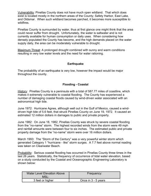
<strong>Vulnerability</strong>: <strong>Pinellas</strong> <strong>County</strong> does not have much open wildl<strong>and</strong>. That which does<br />
exist is located mostly in the northern areas of the <strong>County</strong>; Safety Harbor, East Lake,<br />
<strong>and</strong> Oldsmar. When such wildl<strong>and</strong> becomes parched, it becomes more susceptible to<br />
wildfires.<br />
<strong>Pinellas</strong> <strong>County</strong> is surrounded by water, thus at first glance one might think that the area<br />
could never suffer from drought. Unfortunately, the water is saltwater <strong>and</strong> is not<br />
currently available for human consumption or daily uses. When considering how<br />
densely populated the <strong>County</strong> has become, <strong>and</strong> the high dem<strong>and</strong>s placed on the water<br />
supply daily, the area can be moderately vulnerable to drought.<br />
Maximum Threat: A prolonged drought combined with sunny <strong>and</strong> warm conditions<br />
resulting in very low water levels <strong>and</strong> the need for water rationing.<br />
Earthquake<br />
The probability of an earthquake is very low, however the impact would be major<br />
throughout the county.<br />
Flooding - Coastal<br />
History: <strong>Pinellas</strong> <strong>County</strong> is a peninsula with a total of 587.77 miles of coastline, which<br />
makes it extremely vulnerable to coastal flooding. The <strong>County</strong> has experienced a<br />
number of damaging coastal floods caused by wind-driven water associated with an<br />
astronomical high tide.<br />
June 1972: Hurricane Agnes, although well out in the Gulf of Mexico, caused a winddriven<br />
high tide of 5.6 feet, that struck <strong>Pinellas</strong> <strong>County</strong> on June 19, 1972. It caused an<br />
estimated 12 million dollars in damages to public <strong>and</strong> private property.<br />
June 1982: On June 18, 1982, <strong>Pinellas</strong> <strong>County</strong> was struck by severe coastal flooding<br />
from the “no-name” storm. The highest recorded winds from the storm were 49 mph<br />
<strong>and</strong> rainfall amounts were between four to six inches. The estimated public <strong>and</strong> private<br />
property damage from the “no-name” storm were over 16 million dollars.<br />
March 1993: The “Storm of the Century” was a very powerful winter storm which<br />
generated Category 1 “hurricane - like” storm surges. A 7.7 feet above normal reading<br />
was taken on Clearwater Beach.<br />
Probability: Serious coastal flooding has occurred in <strong>Pinellas</strong> <strong>County</strong> three times in the<br />
last 26 years. Statistically, the frequency of occurrence of tidal water elevation, based<br />
on a study conducted by the Coastal <strong>and</strong> Oceanographic Engineering Laboratory is<br />
shown below:<br />
Water Level Elevation Above<br />
Frequency:<br />
MSL:<br />
3 feet or higher Once in 3 - 5 years


