NASSFELD - Geopark Karnische Alpen
NASSFELD - Geopark Karnische Alpen
NASSFELD - Geopark Karnische Alpen

You also want an ePaper? Increase the reach of your titles
YUMPU automatically turns print PDFs into web optimized ePapers that Google loves.
Farbprofil: ISO - Coated v2 (basICColor)<br />
Komposit Standardbildschirm<br />
english<br />
100<br />
95<br />
75<br />
25<br />
5<br />
0<br />
E<br />
S<br />
N<br />
W<br />
<strong>Karnische</strong>r Höhenweg<br />
(Südalpenweg 03)<br />
Gailtaler Höhenweg<br />
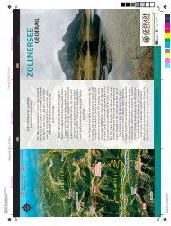
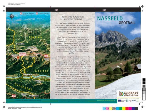
DISCOVERING THE GEOPARK<br />
(ADVENTURE GEOPARK)<br />
The 1000 square kilometer Carnic Alps <strong>Geopark</strong><br />
invites you on a journey back in time to discover<br />
the Earth's past. There is no other place where<br />
one can find within such a small and scenic<br />
landscape so many documents of the<br />
Earth's heritage.<br />
<strong>NASSFELD</strong><br />
GEOTRAIL<br />
100<br />
95<br />
75<br />
25<br />
5<br />
0<br />
100<br />
95<br />
75<br />
25<br />
GEOTRAIL<br />
<strong>NASSFELD</strong><br />
More than 70 sites between the villages of<br />
Feistritz in the eastern Gail Valley and Maria<br />
Luggau in the Lesach Valley can be visited<br />
to discover the journey through time which lasts<br />
several hundred million years. The hiker will<br />
encounter spectacular waterfalls, mystical<br />
canyons, vertical cliffs, quiet mountain lakes<br />
and fossilized marine and terrestrial faunas<br />
and floras.<br />
In the <strong>Geopark</strong> man plays only a minor role. The<br />
keystone is the elementary power of nature and<br />
geological times which convey an unforgettable<br />
impression to every visitor. The exciting history<br />
starts some 500 million years ago. At that time<br />
the oldest rocks of our mountains were deposited<br />
in an ocean on the other side of the globe. Since<br />
then they have been on a real odyssey from cool<br />
climate during the Ordovician to moderate and<br />
tropic latitudes in the Devonian. At the end of<br />
the Palaeozoic Era, the Permian, the area<br />
experienced a desert climate. In the following<br />
Triassic Period the continental plates crossed the<br />
equator and drifted during the Mesozoic and<br />
Cenozoic Eras centimeter by centimeter towards<br />
present latitudes. Finally, during the Pleistocene<br />
Epoch ice formed the landscape as it is seen<br />
today. Some 20.000 years ago the glaciers<br />
started melting and men invaded the <strong>Geopark</strong> to<br />
settle and cultivate mountains and valleys alike.<br />
100<br />
95<br />
75<br />
25<br />
5<br />
5<br />
0<br />
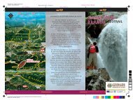
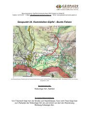
Location of the Naßfeld Geotrail in the <strong>Geopark</strong><br />
Für den Inhalt verantwortlich: Prof. Hans Peter Schönlaub, Kötschach/Mauthen.<br />
Gestaltung: Monika Brüggemann-Ledolter, Geologische Bundesanstalt.<br />
www:geopark-karnische-alpen.at<br />
0<br />
D:\ACINOM\Kundschaft\HPS\<strong>Geopark</strong> Karn Alp\Folder\NassfeldSeite1Aussen.cdr<br />
Montag, 29. Juni 2009 16:36:46
Farbprofil: ISO - Coated v2 (basICColor)<br />
Komposit Standardbildschirm<br />
Geological Survey<br />
100 x 210mm 100 x 210mm<br />
97 x 210mm<br />
ADVENTURE GEOLOGY<br />
www.geologie.ac.at<br />
100<br />
Left: Fossil debris from mainly brachiopods (Genera Productus and Spirifer) from the<br />
Auernig-Formation. (Naßfeld, west of Krone)<br />
Map<br />
100<br />
95<br />
75<br />
Below: Thin section with longitudinal and cross sections of fusulinids<br />
(unicellular Foraminifera) from Limestone Bed s of the top of mountain Auernig.<br />
Bottommost: Leaves of the fern Pecopteris sp. from plant locality west of Krone.<br />
Topographie: BEV - 2009, vervielfältigt mit Genehmigung des BEV in Wien, T2009/56516.<br />
Kam<br />
mleiten<br />
Kühweger Alm<br />
1<br />
998m 2/2<br />
Garnitzengraben<br />
0 500m<br />
2/1<br />
N<br />
95<br />
75<br />
Kühweger Törl<br />
1914m<br />
Gartnerkofel<br />
2195m<br />
25<br />
25<br />
5<br />
5<br />
3<br />
0<br />
Watschiger Alm<br />
1625m<br />
1<br />
4<br />
0<br />
Naßfeldpaß<br />
1530m<br />
5<br />
8<br />
6<br />
7<br />
Gugga<br />
100<br />
95<br />
75<br />
25<br />
5<br />
THE <strong>NASSFELD</strong> GEOTRAIL<br />
In geological textbooks about Austria the term<br />
„Naßfeld“ is almost equivalent to Carboniferous and rich<br />
occurrences of all kinds of marine and land-derived<br />
fossils. About half way up to the pass post-Variscan<br />
deposits unconformably overly older strata. These<br />
younger rocks exhibit almost horizontal bedding which<br />
can best be seen on the southern slope of Mount<br />
Auernig at the state border or at the northern cliff of<br />
Mount Gartnerkofel. The latter represents the youngest<br />
strata in this area reflecting dolomites of Middle Triassic<br />
age some 220 million years old.<br />
Access:<br />
Tröpolach - Road to Naßfeld - Parking Watschig Alm.<br />
Route: Watschig Alm (1625 m) - Kühweg Törl<br />
(1914 m) – Mount Kammleiten (1998 m) – Cable road<br />
Station Gartnerkofel (1960 m) – Mount Garnitzen<br />
(1940 m) – Mount Auernig (1863 m) - Watschig Alm.<br />
Length:<br />
Duration:<br />
About 5 km.<br />
4 - 5 hours.<br />
Auernig<br />
1863m<br />
9<br />
I TA L I E N<br />
Garnitzenberg<br />
1951m<br />
Garnitzenalm<br />
/Krone<br />
10<br />
Krone<br />
Boards:<br />
1: Scenery of Naßfeld 300 million years ago.<br />
2/1: Muschelkalk Conglomerate, the most colourful<br />
rock in the surrounding.<br />
2/2: Pin pricking the mountain - a drill hole to solve<br />
one of the world's mysteries.<br />
Distant view from the peak Kammleiten.<br />
3: The dominating rock of mountain Gartnerkofel.<br />
4: Lithified lime mud.<br />
Panoramic view from Naßfeld to the Hohe Tauern<br />
region.<br />
5: River gravel transformed to quartz conglomerates.<br />
6: Limestones containing miraculous microfossils.<br />
7: The bed with the brachiopods.<br />
8: Mount Garnitzen representing a Carboniferous<br />
sand pit.<br />
9: Mount Auernig in the Sea, testimony of<br />
marine life.<br />
10: Imprints of fossil plants from Mount Corona<br />
as a memory.<br />
100<br />
95<br />
75<br />
25<br />
5<br />
0<br />
Exhibitions and Informations: Visitor Center Dellach im Gailtal,<br />
A-9635 Dellach im Gailtal, 65<br />
ABENTEUER ERDGESCHICHTE<br />
Maps: Austrian map 1:50 000, sheet 198 Weißbriach (BEV-Vienna),<br />
Geological map of Austria, sheet 198 Weißbriach (GBA-Vienna)<br />
0<br />
D:\ACINOM\Kundschaft\HPS\<strong>Geopark</strong> Karn Alp\Folder\NassfeldSeite2Innen.cdr<br />
Montag, 29. Juni 2009 16:41:03