Vector VS131 Receiver - Canal Geomatics
Vector VS131 Receiver - Canal Geomatics
Vector VS131 Receiver - Canal Geomatics

Create successful ePaper yourself
Turn your PDF publications into a flip-book with our unique Google optimized e-Paper software.
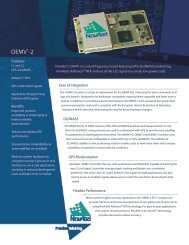
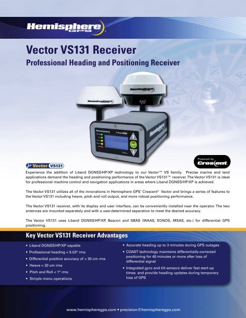
<strong>Vector</strong> <strong>VS131</strong> <strong>Receiver</strong><br />
Professional Heading and Positioning <strong>Receiver</strong><br />
Experience the addition of L-band DGNSS/HP/XP technology to our <strong>Vector</strong> VS family. Precise marine and land<br />
applications demand the heading and positioning performance of the <strong>Vector</strong> <strong>VS131</strong> receiver. The <strong>Vector</strong> <strong>VS131</strong> is ideal<br />
for professional machine control and navigation applications in areas where L-band DGNSS/HP/XP is achieved.<br />
The <strong>Vector</strong> <strong>VS131</strong> utilizes all of the innovations in Hemisphere GPS’ Crescent ® <strong>Vector</strong> and brings a series of features to<br />
the <strong>Vector</strong> <strong>VS131</strong> including heave, pitch and roll output, and more robust positioning performance.<br />
The <strong>Vector</strong> <strong>VS131</strong> receiver, with its display and user interface, can be conveniently installed near the operator. The two<br />
antennas are mounted separately and with a user-determined separation to meet the desired accuracy.<br />
The <strong>Vector</strong> <strong>VS131</strong> uses L-band DGNSS/HP/XP, Beacon and SBAS (WAAS, EGNOS, MSAS, etc.) for differential GPS<br />
positioning.<br />
Key <strong>Vector</strong> <strong>VS131</strong> <strong>Receiver</strong> Advantages<br />
• L-band DGNSS/HP/XP capable<br />
• Professional heading < 0.03° rms<br />
• Differential position accuracy of < 30 cm rms<br />
• Heave < 30 cm rms<br />
• Pitch and Roll < 1° rms<br />
• Simple menu operations<br />
• Accurate heading up to 3 minutes during GPS outages<br />
• COAST technology maintains differentially-corrected<br />
positioning for 40 minutes or more after loss of<br />
differential signal<br />
• Integrated gyro and tilt sensors deliver fast start-up<br />
times and provide heading updates during temporary<br />
loss of GPS<br />
www.hemispheregps.com • precision@hemispheregps.com
<strong>Vector</strong> <strong>VS131</strong> <strong>Receiver</strong><br />
GPS Sensor Specifications<br />
<strong>Receiver</strong> Type: L1, C/A code, with carrier phase smoothing<br />
Signals Received: GPS<br />
Channels: 270<br />
GPS Sensitivity: -142dBm<br />
SBAS Tracking: 2-channel, parallel tracking<br />
Update Rate:<br />
10 Hz standard, 20 Hz available by subscription<br />
Horizontal Accuracy: RMS (67%) 2DRMS (95%)<br />
RTK: 1 10 mm + 1 ppm 20 mm + 2 ppm<br />
L-band DGNSS/HP/XP<br />
(OmniSTAR): 2, 7 0.3 m 0.6 m<br />
SBAS (WAAS): 2 0.3 m 0.6 m<br />
Autonomous, no SA: 2 1.2 m 2.5 m<br />
Heading Accuracy: < 0.33˚ rms @ 0.5 m antenna separation<br />
< 0.17˚ rms @ 1.0 m antenna separation<br />
< 0.08˚ rms @ 2.0 m antenna separation<br />
< 0.03˚ rms @ 5.0 m antenna separation<br />
Pitch/Roll Accuracy: < 1˚ rms<br />
Heave Accuracy: 30 cm rms 6<br />
Timing (1PPS) Accuracy: 50 ns<br />
Rate of Turn:<br />
90˚/s maximum<br />
Cold Start:<br />
< 60 s (no almanac or RTC)<br />
Warm Start:<br />
< 20 s typical (almanac and RTC)<br />
Hot Start:<br />
< 1 s typical (almanac, RTC and position)<br />
Heading Fix:<br />
< 10 s typical (valid position)<br />
Maximum Speed: 1,850 mph (999 kts)<br />
Maximum Altitude: 18,288 m (60,000 ft)<br />
Power<br />
Input Voltage:<br />
Power Consumption:<br />
Current Consumption:<br />
Power Isolation:<br />
Reverse Polarity Protection:<br />
Antenna Short Circuit<br />
Protection:<br />
8 to 36 VDC<br />
< 4.5 W nominal (GPS (L1) and L-band<br />
DGNSS/HP/XP)<br />
< 3.6 W nominal (GPS (L1)<br />
< 0.38 A nominal (GPS (L1) and L-band<br />
DGNSS/HP/XP)<br />
< 0.30 A nominal (GPS (L1)<br />
500 V<br />
Yes<br />
Yes<br />
Environmental<br />
Operating Temperature: -30°C to + 70°C (-22°F to + 158°F)<br />
Storage Temperature: -40°C to + 85°C (-40°F to + 185°F)<br />
Humidity:<br />
95% non-condensing<br />
Enclosure Rating: IP66 (IEC 60529)<br />
Shock and Vibration: Mechanical Shock: EP455 Section 5.14.1<br />
Vibration: EP455 Section 5.15.1 Random<br />
EMC:<br />
CE (IEC 60945 Emissions and Immunity)<br />
FCC Part 15, Subpart B<br />
CISPR22<br />
IMO Wheelmark Certification: No<br />
L-band DGNSS/HP/XP Sensor Specifications<br />
Sensitivity:<br />
-130 dBm<br />
Channel Spacing: 7.5 kHz<br />
Satellite Selection: Manual and Automatic<br />
Reacquisition Time: 15 seconds (typical)<br />
Rejection:<br />
15 kHz spacing > 30 dB,<br />
300 kHz spacing > 60 dB<br />
Processor:<br />
DSP for demodulation and protocol decoding<br />
module provides processing for the<br />
differential algorithms<br />
Command Support: Reports L-band DGNSS/HP/XP (OmniSTAR)<br />
region and satellite info, allows input and status<br />
of L-band DGNSS/HP/XP (OmniSTAR) subscription,<br />
bit error rate (BER) output for reception quality<br />
indication, and manual frequency tuning<br />
Communications<br />
Serial Ports:<br />
2 full-duplex RS-232 ports<br />
USB Ports:<br />
1 USB-B<br />
Baud Rates: 4800 - 115200<br />
Correction I/O Protocol: RTCM v2.3 (DGPS), RTCM SC-104, L-Dif TM 3<br />
Data I/O Protocol: NMEA 0183, Crescent binary 3 , L-Dif<br />
Timing Output: 1PPS CMOS, active low, falling edge sync,<br />
10 kΩ, 10pF load<br />
Mechanical<br />
Dimensions:<br />
Weight:<br />
Status Indications (LED):<br />
Power Switch:<br />
Power Connector:<br />
Data Connector:<br />
Antenna Connectors:<br />
Aiding Devices<br />
Gyro:<br />
Tilt Sensors:<br />
20.2 L x 12.0 W x 7.5 H (cm)<br />
8.0 L x 4.7 W x 3.0 H (in)<br />
~1.1 kg (~2.5 lbs.)<br />
Power, Primary and Secondary GPS lock,<br />
Differential lock, DGPS position, Heading,<br />
RTK lock, L-band DGNSS/HP/XP lock<br />
Front panel soft switch<br />
2-pin ODU metal circular<br />
DB9 (sealed)<br />
2 TNC (female)<br />
Provides smooth heading, fast heading<br />
reacquisition and reliable < 1˚ per minute<br />
heading for periods up to 3 minute when<br />
loss of GPS has occurred 4<br />
Provide pitch, roll data and assist in fast<br />
start-up and reacquisition of<br />
heading solution.<br />
Authorized Distributor:<br />
HEMISPHERE GPS<br />
4110 - 9th Street S.E.<br />
Calgary, AB T2G 3C4<br />
Canada<br />
Phone: 403.259.3311<br />
Fax: 403.259.8866<br />
precision@hemispheregps.com<br />
www.hemispheregps.com<br />
1 Depends on multipath environment, number of satellites in view, satellite<br />
geometry, baseline length (for local services), and ionospheric activity<br />
2 Depends on multipath environment, number of satellites in view and<br />
satellite geometry<br />
3 Hemisphere GPS proprietary<br />
4 Under static conditions<br />
5 This is the minimum safe distance measured when the product is placed<br />
in the vicinity of the steering magnetic compass. The ISO 694 defines<br />
“vicinity” relative to the compass as within 5 m (16.4 ft) separation.<br />
6 Based on a 40 second time constant<br />
7 Requires a subscription from OmniSTAR<br />
Copyright 2012, Hemisphere GPS. All rights reserved. Specifications subject to change without notice.<br />
Hemisphere GPS, Hemisphere GPS logo, Crescent, Crescent logo, <strong>Vector</strong>, <strong>VS131</strong>, L-Dif and COAST are trademarks of Hemisphere GPS.<br />
OmniSTAR is a registered trademark of OmniSTAR, Inc. Rev. 9/12.