- Page 2 and 3: Satellite Remote Sensing and GIS Ap
- Page 4 and 5: FOREWORD
- Page 6 and 7: Crop Growth and Productivity Monito
- Page 8 and 9: 2 Satellite Remote Sensing and GIS
- Page 10 and 11: 4 Satellite Remote Sensing and GIS
- Page 12 and 13: 6 Satellite Remote Sensing and GIS
- Page 14 and 15: 8 Satellite Remote Sensing and GIS
- Page 16 and 17: 10 Satellite Remote Sensing and GIS
- Page 18 and 19: 12 Satellite Remote Sensing and GIS
- Page 20 and 21: 14 Satellite Remote Sensing and GIS
- Page 22 and 23: 16 Satellite Remote Sensing and GIS
- Page 24 and 25: 18 Satellite Remote Sensing and GIS
- Page 26 and 27: 20 Satellite Remote Sensing and GIS
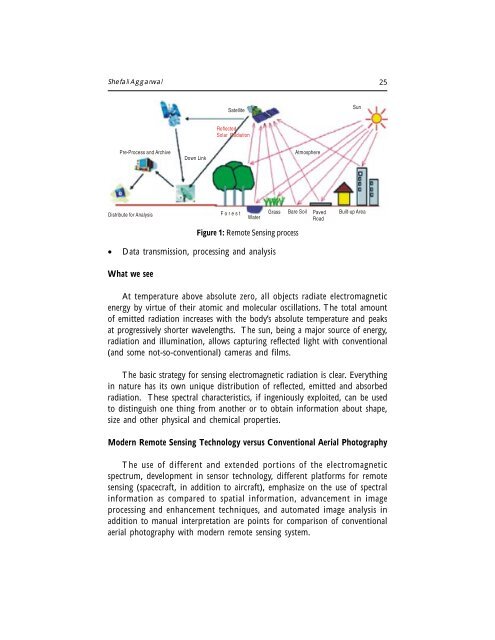
- Page 28 and 29: PRINCIPLES OF REMOTE SENSING Shefal
- Page 32 and 33: Shefali Aggarwal 27 After the wars
- Page 34 and 35: Shefali Aggarwal 29 Table 2: Princi
- Page 36 and 37: Shefali Aggarwal 31 by the earth’
- Page 38 and 39: Shefali Aggarwal 33 Reflectance (%)
- Page 40 and 41: Shefali Aggarwal 35 Atmospheric Sca
- Page 42 and 43: Shefali Aggarwal 37 reduces the amo
- Page 44 and 45: EARTH RESOURCE SATELLITES Shefali A
- Page 46 and 47: Shefali Aggarwal 41 Figure 1. Geo-s
- Page 48 and 49: Shefali Aggarwal 43 REMOTE SENSING
- Page 50 and 51: Shefali Aggarwal 45 Many electronic
- Page 52 and 53: Shefali Aggarwal 47 emissions. Ther
- Page 54 and 55: Shefali Aggarwal 49 until January 6
- Page 56 and 57: Shefali Aggarwal 51 Table 4. Charac
- Page 58 and 59: Shefali Aggarwal 53 Table 5. Charac
- Page 60 and 61: Shefali Aggarwal 55 Table 6. Charac
- Page 62 and 63: Shefali Aggarwal 57 6.6., 10.6, 18
- Page 64 and 65: Shefali Aggarwal 59 Table 7. Charac
- Page 66 and 67: Shefali Aggarwal 61 Table 9. Charac
- Page 68 and 69: Shefali Aggarwal 63 Satellite Launc
- Page 70 and 71: Shefali Aggarwal 65 CONCLUSIONS Sin
- Page 72 and 73: 68 Meteorological satellites there
- Page 74 and 75: 70 Meteorological satellites the ph
- Page 76 and 77: 72 Meteorological satellites measur
- Page 78 and 79: 74 Meteorological satellites DATA F
- Page 80 and 81:
76 Meteorological satellites window
- Page 82 and 83:
78 Meteorological satellites and pr
- Page 84 and 85:
DIGITAL IMAGE PROCESSING Minakshi K
- Page 86 and 87:
Minakshi Kumar 83 COLOR COMPOSITES
- Page 88 and 89:
Minakshi Kumar 85 (A) (B) (C) (D) F
- Page 90 and 91:
Minakshi Kumar 87 255 Frequency His
- Page 92 and 93:
Minakshi Kumar 89 image behaviour w
- Page 94 and 95:
Minakshi Kumar 91 Sunlight Figure 5
- Page 96 and 97:
Minakshi Kumar 93 observing and sep
- Page 98 and 99:
Minakshi Kumar 95 the identity of t
- Page 100 and 101:
Minakshi Kumar 97 Parallelepiped Cl
- Page 102 and 103:
Minakshi Kumar 99 Band 3 digital nu
- Page 104 and 105:
Minakshi Kumar 101 omission (exclus
- Page 106 and 107:
FUNDAMENTALS OF GEOGRAPHICAL INFORM
- Page 108 and 109:
P.L.N. Raju 105 related to geograph
- Page 110 and 111:
P.L.N. Raju 107 A related term that
- Page 112 and 113:
P.L.N. Raju 109 Geographic informat
- Page 114 and 115:
P.L.N. Raju 111 through education a
- Page 116 and 117:
P.L.N. Raju 113 beautiful. Figure 1
- Page 118 and 119:
P.L.N. Raju 115 capabilities for st
- Page 120 and 121:
P.L.N. Raju 117 (ii) Errors associa
- Page 122 and 123:
P.L.N. Raju 119 • Soil resources
- Page 124 and 125:
FUNDAMENTALS OF GPS P.L.N. Raju Geo
- Page 126 and 127:
P.L.N. Raju 123 term for receiver c
- Page 128 and 129:
P.L.N. Raju 125 SEGMENTS OF GPS For
- Page 130 and 131:
P.L.N. Raju 127 Under Block-I, NAVS
- Page 132 and 133:
P.L.N. Raju 129 GPS receiver normal
- Page 134 and 135:
P.L.N. Raju 131 With a bit rate of
- Page 136 and 137:
P.L.N. Raju 133 - Monitoring and co
- Page 138 and 139:
P.L.N. Raju 135 Antenna Sensitive a
- Page 140 and 141:
P.L.N. Raju 137 Power Supply First
- Page 142 and 143:
P.L.N. Raju 139 T1 4100 GPS Navigat
- Page 144 and 145:
P.L.N. Raju 141 The dual frequency
- Page 146 and 147:
P.L.N. Raju 143 and has a codeless
- Page 148 and 149:
P.L.N. Raju 145 - Low power consump
- Page 150 and 151:
P.L.N. Raju 147 Table 5. Error Sour
- Page 152 and 153:
P.L.N. Raju 149 TRIMBLE GPS AS A RO
- Page 154 and 155:
SPATIAL DATA ANALYSIS P.L.N. Raju G
- Page 156 and 157:
P.L.N. Raju 153 Parcel Size Value L
- Page 158 and 159:
P.L.N. Raju 155 Example: Creating a
- Page 160 and 161:
P.L.N. Raju 157 Figure 6: The most
- Page 162 and 163:
P.L.N. Raju 159 As stated above, th
- Page 164 and 165:
P.L.N. Raju 161 (a) (b) Figure 9: (
- Page 166 and 167:
P.L.N. Raju 163 The most common bas
- Page 168 and 169:
P.L.N. Raju 165 RASTER BASED SPATIA
- Page 170 and 171:
P.L.N. Raju 167 Local Functions Loc
- Page 172 and 173:
P.L.N. Raju 169 Zonal Functions Zon
- Page 174 and 175:
P.L.N. Raju 171 Another useful glob
- Page 176 and 177:
P.L.N. Raju 173 specify to find 10
- Page 178 and 179:
RETRIEVAL OF AGROMETEOROLOGICAL PAR
- Page 180 and 181:
S.K. Saha 177 µs = Cos θs π. L =
- Page 182 and 183:
S.K. Saha 179 Saha and Pande (1995a
- Page 184 and 185:
S.K. Saha 181 Surface temperature c
- Page 186 and 187:
S.K. Saha 183 where, V is the wave
- Page 188 and 189:
S.K. Saha 185 Figure 5: (1) FCC ( C
- Page 190 and 191:
S.K. Saha 187 ∧ 24 hrs = ∧ inst
- Page 192 and 193:
S.K. Saha 189 APAR = fPAR . PAR whe
- Page 194 and 195:
S.K. Saha 191 where, ∧ is the eva
- Page 196 and 197:
S.K. Saha 193 Brutsaert, W. and Sug
- Page 198 and 199:
RETRIEVAL OF AGROMETEOROLOGICAL PAR
- Page 200 and 201:
C.M. Kishtawal 197 imagery this inf
- Page 202 and 203:
C.M. Kishtawal 199 Because cloud to
- Page 204 and 205:
C.M. Kishtawal 201 vertically, it g
- Page 206 and 207:
C.M. Kishtawal 203 Soil Moisture Re
- Page 208 and 209:
C.M. Kishtawal 205 ground (pyranome
- Page 210 and 211:
C.M. Kishtawal 207 Wavelength (µm)
- Page 212 and 213:
C.M. Kishtawal 209 Deserts and Vege
- Page 214 and 215:
C.M. Kishtawal 211 ACKNOWLEDGEMENTS
- Page 216 and 217:
214 Remote Sensing and GIS Applicat
- Page 218 and 219:
216 Remote Sensing and GIS Applicat
- Page 220 and 221:
218 Remote Sensing and GIS Applicat
- Page 222 and 223:
220 Remote Sensing and GIS Applicat
- Page 224 and 225:
222 Remote Sensing and GIS Applicat
- Page 226 and 227:
224 Remote Sensing and GIS Applicat
- Page 228 and 229:
226 Remote Sensing and GIS Applicat
- Page 230 and 231:
228 Remote Sensing and GIS Applicat
- Page 232 and 233:
230 Remote Sensing and GIS Applicat
- Page 234 and 235:
232 Remote Sensing and GIS Applicat
- Page 236 and 237:
CROP GROWTH MODELING AND ITS APPLIC
- Page 238 and 239:
V. Radha Krishna Murthy 237 systems
- Page 240 and 241:
V. Radha Krishna Murthy 239 GENOTYP
- Page 242 and 243:
V. Radha Krishna Murthy 241 h. Desc
- Page 244 and 245:
V. Radha Krishna Murthy 243 is to p
- Page 246 and 247:
V. Radha Krishna Murthy 245 adaptat
- Page 248 and 249:
V. Radha Krishna Murthy 247 Table 3
- Page 250 and 251:
V. Radha Krishna Murthy 249 conditi
- Page 252 and 253:
V. Radha Krishna Murthy 251 Now, cr
- Page 254 and 255:
V. Radha Krishna Murthy 253 2. Defi
- Page 256 and 257:
V. Radha Krishna Murthy 255 (1995)
- Page 258 and 259:
V. Radha Krishna Murthy 257 9. One
- Page 260 and 261:
V. Radha Krishna Murthy 259 Hammer,
- Page 262 and 263:
V. Radha Krishna Murthy 261 Thornto
- Page 264 and 265:
264 Crop Growth and Productivity Mo
- Page 266 and 267:
266 Crop Growth and Productivity Mo
- Page 268 and 269:
268 Crop Growth and Productivity Mo
- Page 270 and 271:
270 Crop Growth and Productivity Mo
- Page 272 and 273:
272 Crop Growth and Productivity Mo
- Page 274 and 275:
274 Crop Growth and Productivity Mo
- Page 276 and 277:
276 Crop Growth and Productivity Mo
- Page 278 and 279:
278 Crop Growth and Productivity Mo
- Page 280 and 281:
280 Crop Growth and Productivity Mo
- Page 282 and 283:
282 Crop Growth and Productivity Mo
- Page 284 and 285:
284 Crop Growth and Productivity Mo
- Page 286 and 287:
286 Crop Growth and Productivity Mo
- Page 288 and 289:
288 Crop Growth and Productivity Mo
- Page 290 and 291:
DROUGHTS & FLOODS ASSESSMENT AND MO
- Page 292 and 293:
A.T. Jeyaseelan 293 Based on the ca
- Page 294 and 295:
A.T. Jeyaseelan 295 (NCRC) of Unite
- Page 296 and 297:
A.T. Jeyaseelan 297 during daytime
- Page 298 and 299:
A.T. Jeyaseelan 299 is used in vari
- Page 300 and 301:
A.T. Jeyaseelan 301 Vegetation Moni
- Page 302 and 303:
A.T. Jeyaseelan 303 Joint Research
- Page 304 and 305:
A.T. Jeyaseelan 305 NOAA images can
- Page 306 and 307:
A.T. Jeyaseelan 307 coastline. In a
- Page 308 and 309:
A.T. Jeyaseelan 309 gains from usin
- Page 310 and 311:
A.T. Jeyaseelan 311 Gruber, A. 1973
- Page 312 and 313:
A.T. Jeyaseelan 313 Scofield, R.A.,
- Page 314 and 315:
316 Water and Wind induced Soil Ero
- Page 316 and 317:
318 Water and Wind induced Soil Ero
- Page 318 and 319:
320 Water and Wind induced Soil Ero
- Page 320 and 321:
322 Water and Wind induced Soil Ero
- Page 322 and 323:
324 Water and Wind induced Soil Ero
- Page 324 and 325:
326 Water and Wind induced Soil Ero
- Page 326 and 327:
328 Water and Wind induced Soil Ero
- Page 328 and 329:
330 Water and Wind induced Soil Ero
- Page 330 and 331:
332 Satellite Based Weather Forecas
- Page 332 and 333:
334 Satellite Based Weather Forecas
- Page 334 and 335:
336 Satellite Based Weather Forecas
- Page 336 and 337:
338 Satellite Based Weather Forecas
- Page 338 and 339:
340 Satellite Based Weather Forecas
- Page 340 and 341:
342 Satellite Based Weather Forecas
- Page 342 and 343:
344 Satellite Based Weather Forecas
- Page 344 and 345:
346 Satellite Based Weather Forecas
- Page 346 and 347:
348 Satellite-Base Agro-Advisory Se
- Page 348 and 349:
350 Satellite-Base Agro-Advisory Se
- Page 350 and 351:
352 Satellite-Base Agro-Advisory Se
- Page 352 and 353:
354 Satellite-Base Agro-Advisory Se
- Page 354 and 355:
356 Satellite-Base Agro-Advisory Se
- Page 356 and 357:
358 Satellite-Base Agro-Advisory Se
- Page 358 and 359:
FOREST FIRE AND DEGRADATION ASSESSM
- Page 360 and 361:
P.S. Roy 363 of tropical forest and
- Page 362 and 363:
P.S. Roy 365 “burnt center” of
- Page 364 and 365:
P.S. Roy 367 Comparatively little i
- Page 366 and 367:
P.S. Roy 369 which would be a basic
- Page 368 and 369:
P.S. Roy 371 evaporation. Lack of a
- Page 370 and 371:
P.S. Roy 373 such wild land fires.
- Page 372 and 373:
P.S. Roy 375 monitoring and assessi
- Page 374 and 375:
P.S. Roy 377 The fire episode of 19
- Page 376 and 377:
P.S. Roy 379 • Rainfall data •
- Page 378 and 379:
P.S. Roy 381 FR = [10Vi = 1-10 (5H
- Page 380 and 381:
P.S. Roy 383 as 130.96 km 2 or 2.96
- Page 382 and 383:
P.S. Roy 385 Table 5. Area (km 2 )
- Page 384 and 385:
P.S. Roy 387 The Forest Canopy Dens
- Page 386 and 387:
P.S. Roy 389 80%. However, some dev
- Page 388 and 389:
P.S. Roy 391 different techniques.
- Page 390 and 391:
P.S. Roy 393 • Identification of
- Page 392 and 393:
P.S. Roy 395 map derived from FCD M
- Page 394 and 395:
P.S. Roy 397 Ehrlich D., E.F. Lambi
- Page 396 and 397:
P.S. Roy 399 Phillips, J. 1965. Fir
- Page 398 and 399:
DESERT LOCUST MONITORING SYSTEM - R
- Page 400 and 401:
D. Dutta, et al. 403 unusually warm
- Page 402 and 403:
D. Dutta, et al. 405 ii. Structured
- Page 404 and 405:
D. Dutta, et al. 407 Spatial Databa
- Page 406 and 407:
D. Dutta, et al. 409 Figure 5a: Dat
- Page 408 and 409:
D. Dutta, et al. 411 From locust si
- Page 410 and 411:
D. Dutta, et al. 413 (A) (B) (C) (D
- Page 412 and 413:
D. Dutta, et al. 415 Figure 11: Att
- Page 414 and 415:
D. Dutta, et al. 417 favourable (Fi
- Page 416 and 417:
D. Dutta, et al. 419 Climate suitab
- Page 418 and 419:
D. Dutta, et al. 421 Figure 18: Air
- Page 420 and 421:
D. Dutta, et al. 423 the input valu
- Page 422 and 423:
426 Workshop Evaluation fundamental


![View full document [PDF 988.55 KB] - PreventionWeb](https://img.yumpu.com/47733942/1/184x260/view-full-document-pdf-98855-kb-preventionweb.jpg?quality=85)
![View full document (in French) [PDF 4.96 MB] - PreventionWeb](https://img.yumpu.com/47223870/1/184x260/view-full-document-in-french-pdf-496-mb-preventionweb.jpg?quality=85)


![View full document [PDF 25.02 MB] - PreventionWeb](https://img.yumpu.com/44204570/1/190x234/view-full-document-pdf-2502-mb-preventionweb.jpg?quality=85)