L-3 Klein 5900 Multi-Beam Side Scan Sonar (Click here for PDF)
L-3 Klein 5900 Multi-Beam Side Scan Sonar (Click here for PDF)
L-3 Klein 5900 Multi-Beam Side Scan Sonar (Click here for PDF)

You also want an ePaper? Increase the reach of your titles
YUMPU automatically turns print PDFs into web optimized ePapers that Google loves.
MULTI-BEAM SIDE SCAN SONAR (MBSS)<br />
Since the introduction of the System 5000 in 1996,<br />
well over 100 systems have been deployed worldwide<br />
and most remain in service today. In addition to<br />
various commercial sales, some of the government<br />
organizations using the Series 5000 systems include:<br />
the Royal Australian Navy (DSTO), the French Navy<br />
(GESMA), the U.S. National Oceanic and Atmospheric<br />
Administration (NOAA), the U.S. Naval Oceanographic<br />
Office (NAVO), the U.S. Navy MCM Fleet (Army/Navy<br />
nomenclature: ANSQH-4B), the U.S. Navy EOD<br />
Groups, the Defense Research Establishment (DRE)<br />
of Canada, the Estonia Navy MCMVs, the Indian Navy<br />
MCMVs, the Japanese Navy, the Netherlands Navy,<br />
the Republic of Korea Navy and the Finnish Navy.<br />
The along-track resolution of the System <strong>5900</strong> is<br />
6.2 cm out to 50 m (constant), 9.3 cm out to 75 m<br />
(constant), 12.4 cm out to 100 m (constant) and<br />
increasing to 0.07 degrees <strong>for</strong> ranges greater than<br />
100 m. The across-track resolution of the System<br />
<strong>5900</strong> is 4.0 cm nominal, at all ranges.<br />
The System <strong>5900</strong> MBSS also uses dynamic beamsteering<br />
image stabilization techniques to remove<br />
artifacts caused by tow vehicle motion which would<br />
otherwise blur seabed images — especially at longer<br />
range w<strong>here</strong> the effects due to angular perturbations<br />
are more pronounced. This is a marked improvement<br />
over the System 5000 family, which produced<br />
successive beams perpendicular to the tow body and<br />
were more susceptible to compressed or elongated<br />
images due to excessive towfish yaw. Image<br />
stabilization helps to effectively extend the range of<br />
the sonar by minimizing this distortion.<br />
An added benefit of the System <strong>5900</strong> MBSS is a<br />
pseudo geo-referenced seafloor image. Like all towed<br />
side scan sonar systems, the System <strong>5900</strong> has no<br />
absolute position reference — hence the ability to<br />
provide a truly “geo-referenced” image is impossible.<br />
However, the advanced back-projection beam<strong>for</strong>mer<br />
used on the System <strong>5900</strong> places adjacent sonar<br />
swaths on the seabed perpendicular to the best<br />
estimate of the tow body trajectory, thus producing a<br />
smooth, more accurate waterfall image in the seabed<br />
than a conventional towed side scan plat<strong>for</strong>m.<br />
The <strong>Klein</strong> System <strong>5900</strong> sonar is capable of producing<br />
sonar imagery similar in quality to that produced by<br />
military multi-beam side scan sonar systems, which<br />
include the AN/AQS-14 and the AN/AQS-20.<br />
SWATH BATHYMETRIC SONAR<br />
Integrated into the System <strong>5900</strong> sonar architecture is<br />
a Swath Bathymetric <strong>Sonar</strong> (SBS). This sonar uses<br />
advanced interferometric signal processing to<br />
produce simultaneous estimates of the seabed<br />
topography out to the full-swath extent of the sonar,<br />
typically 10–12 times the overall altitude of the tow<br />
fish. This data is coregistered with the resulting side<br />
scan backscatter imagery and can be used to more<br />
accurately position seabed targets.<br />
<strong>Side</strong>-looking sonars that do not have the ability to<br />
per<strong>for</strong>m bathymetric measurements must assume a<br />
locally flat bottom when measuring the location of<br />
seabed targets. This can result in target position<br />
errors on the order of meters when surveying over<br />
sloped bottoms. This added seabed topographic<br />
measurement capability is extremely advantageous<br />
when per<strong>for</strong>ming missions involving shallow water,<br />
rapid area assessment.<br />
GAP-FILLER SONAR<br />
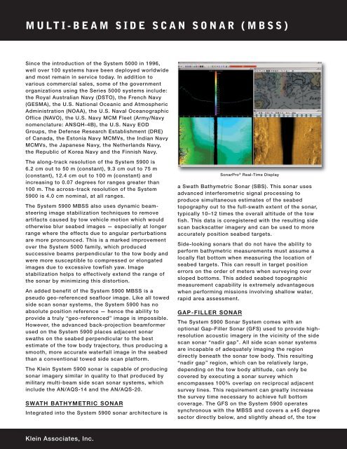
<strong>Sonar</strong>Pro ® Real-Time Display<br />
The System <strong>5900</strong> <strong>Sonar</strong> System comes with an<br />
optional Gap-Filler <strong>Sonar</strong> (GFS) used to provide highresolution<br />
acoustic imagery in the vicinity of the side<br />
scan sonar “nadir gap”. All side scan sonar systems<br />
are incapable of adequately imaging the region<br />
directly beneath the sonar tow body. This resulting<br />
“nadir gap” region, which can be relatively large,<br />
depending on the tow body altitude, can only be<br />
covered by executing a sonar survey which<br />
encompasses 100% overlap on reciprocal adjacent<br />
survey lines. This requirement can greatly increase<br />
the survey time necessary to achieve full bottom<br />
coverage. The GFS on the System <strong>5900</strong> operates<br />
synchronous with the MBSS and covers a ±45 degree<br />
sector directly below, and slightly ahead of, the tow<br />
<strong>Klein</strong> Associates, Inc.