L-3 Klein 5900 Multi-Beam Side Scan Sonar (Click here for PDF)
L-3 Klein 5900 Multi-Beam Side Scan Sonar (Click here for PDF)
L-3 Klein 5900 Multi-Beam Side Scan Sonar (Click here for PDF)

You also want an ePaper? Increase the reach of your titles
YUMPU automatically turns print PDFs into web optimized ePapers that Google loves.
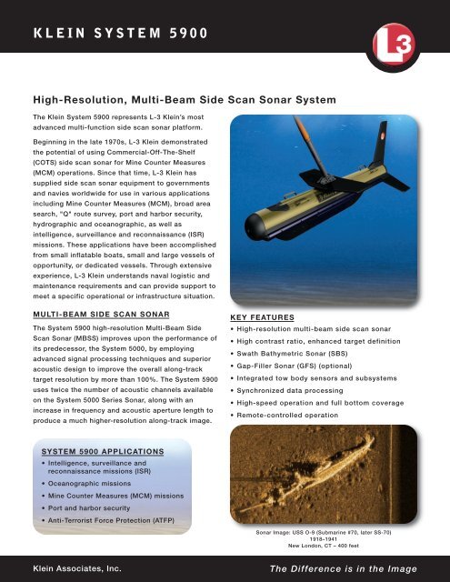
KLEIN SYSTEM <strong>5900</strong><br />
High-Resolution, <strong>Multi</strong>-<strong>Beam</strong> <strong>Side</strong> <strong>Scan</strong> <strong>Sonar</strong> System<br />
The <strong>Klein</strong> System <strong>5900</strong> represents L-3 <strong>Klein</strong>’s most<br />
advanced multi-function side scan sonar plat<strong>for</strong>m.<br />
Beginning in the late 1970s, L-3 <strong>Klein</strong> demonstrated<br />
the potential of using Commercial-Off-The-Shelf<br />
(COTS) side scan sonar <strong>for</strong> Mine Counter Measures<br />
(MCM) operations. Since that time, L-3 <strong>Klein</strong> has<br />
supplied side scan sonar equipment to governments<br />
and navies worldwide <strong>for</strong> use in various applications<br />
including Mine Counter Measures (MCM), broad area<br />
search, "Q" route survey, port and harbor security,<br />
hydrographic and oceanographic, as well as<br />
intelligence, surveillance and reconnaissance (ISR)<br />
missions. These applications have been accomplished<br />
from small inflatable boats, small and large vessels of<br />
opportunity, or dedicated vessels. Through extensive<br />
experience, L-3 <strong>Klein</strong> understands naval logistic and<br />
maintenance requirements and can provide support to<br />
meet a specific operational or infrastructure situation.<br />
MULTI-BEAM SIDE SCAN SONAR<br />
The System <strong>5900</strong> high-resolution <strong>Multi</strong>-<strong>Beam</strong> <strong>Side</strong><br />
<strong>Scan</strong> <strong>Sonar</strong> (MBSS) improves upon the per<strong>for</strong>mance of<br />
its predecessor, the System 5000, by employing<br />
advanced signal processing techniques and superior<br />
acoustic design to improve the overall along-track<br />
target resolution by more than 100%. The System <strong>5900</strong><br />
uses twice the number of acoustic channels available<br />
on the System 5000 Series <strong>Sonar</strong>, along with an<br />
increase in frequency and acoustic aperture length to<br />
produce a much higher-resolution along-track image.<br />
KEY FEATURES<br />
• High-resolution multi-beam side scan sonar<br />
• High contrast ratio, enhanced target definition<br />
• Swath Bathymetric <strong>Sonar</strong> (SBS)<br />
• Gap-Filler <strong>Sonar</strong> (GFS) (optional)<br />
• Integrated tow body sensors and subsystems<br />
• Synchronized data processing<br />
• High-speed operation and full bottom coverage<br />
• Remote-controlled operation<br />
SYSTEM <strong>5900</strong> APPLICATIONS<br />
• Intelligence, surveillance and<br />
reconnaissance missions (ISR)<br />
• Oceanographic missions<br />
• Mine Counter Measures (MCM) missions<br />
• Port and harbor security<br />
• Anti-Terrorist Force Protection (ATFP)<br />
<strong>Sonar</strong> Image: USS O-9 (Submarine #70, later SS-70)<br />
1918–1941<br />
New London, CT – 400 feet<br />
<strong>Klein</strong> Associates, Inc.<br />
The Difference is in the Image
MULTI-BEAM SIDE SCAN SONAR (MBSS)<br />
Since the introduction of the System 5000 in 1996,<br />
well over 100 systems have been deployed worldwide<br />
and most remain in service today. In addition to<br />
various commercial sales, some of the government<br />
organizations using the Series 5000 systems include:<br />
the Royal Australian Navy (DSTO), the French Navy<br />
(GESMA), the U.S. National Oceanic and Atmospheric<br />
Administration (NOAA), the U.S. Naval Oceanographic<br />
Office (NAVO), the U.S. Navy MCM Fleet (Army/Navy<br />
nomenclature: ANSQH-4B), the U.S. Navy EOD<br />
Groups, the Defense Research Establishment (DRE)<br />
of Canada, the Estonia Navy MCMVs, the Indian Navy<br />
MCMVs, the Japanese Navy, the Netherlands Navy,<br />
the Republic of Korea Navy and the Finnish Navy.<br />
The along-track resolution of the System <strong>5900</strong> is<br />
6.2 cm out to 50 m (constant), 9.3 cm out to 75 m<br />
(constant), 12.4 cm out to 100 m (constant) and<br />
increasing to 0.07 degrees <strong>for</strong> ranges greater than<br />
100 m. The across-track resolution of the System<br />
<strong>5900</strong> is 4.0 cm nominal, at all ranges.<br />
The System <strong>5900</strong> MBSS also uses dynamic beamsteering<br />
image stabilization techniques to remove<br />
artifacts caused by tow vehicle motion which would<br />
otherwise blur seabed images — especially at longer<br />
range w<strong>here</strong> the effects due to angular perturbations<br />
are more pronounced. This is a marked improvement<br />
over the System 5000 family, which produced<br />
successive beams perpendicular to the tow body and<br />
were more susceptible to compressed or elongated<br />
images due to excessive towfish yaw. Image<br />
stabilization helps to effectively extend the range of<br />
the sonar by minimizing this distortion.<br />
An added benefit of the System <strong>5900</strong> MBSS is a<br />
pseudo geo-referenced seafloor image. Like all towed<br />
side scan sonar systems, the System <strong>5900</strong> has no<br />
absolute position reference — hence the ability to<br />
provide a truly “geo-referenced” image is impossible.<br />
However, the advanced back-projection beam<strong>for</strong>mer<br />
used on the System <strong>5900</strong> places adjacent sonar<br />
swaths on the seabed perpendicular to the best<br />
estimate of the tow body trajectory, thus producing a<br />
smooth, more accurate waterfall image in the seabed<br />
than a conventional towed side scan plat<strong>for</strong>m.<br />
The <strong>Klein</strong> System <strong>5900</strong> sonar is capable of producing<br />
sonar imagery similar in quality to that produced by<br />
military multi-beam side scan sonar systems, which<br />
include the AN/AQS-14 and the AN/AQS-20.<br />
SWATH BATHYMETRIC SONAR<br />
Integrated into the System <strong>5900</strong> sonar architecture is<br />
a Swath Bathymetric <strong>Sonar</strong> (SBS). This sonar uses<br />
advanced interferometric signal processing to<br />
produce simultaneous estimates of the seabed<br />
topography out to the full-swath extent of the sonar,<br />
typically 10–12 times the overall altitude of the tow<br />
fish. This data is coregistered with the resulting side<br />
scan backscatter imagery and can be used to more<br />
accurately position seabed targets.<br />
<strong>Side</strong>-looking sonars that do not have the ability to<br />
per<strong>for</strong>m bathymetric measurements must assume a<br />
locally flat bottom when measuring the location of<br />
seabed targets. This can result in target position<br />
errors on the order of meters when surveying over<br />
sloped bottoms. This added seabed topographic<br />
measurement capability is extremely advantageous<br />
when per<strong>for</strong>ming missions involving shallow water,<br />
rapid area assessment.<br />
GAP-FILLER SONAR<br />
<strong>Sonar</strong>Pro ® Real-Time Display<br />
The System <strong>5900</strong> <strong>Sonar</strong> System comes with an<br />
optional Gap-Filler <strong>Sonar</strong> (GFS) used to provide highresolution<br />
acoustic imagery in the vicinity of the side<br />
scan sonar “nadir gap”. All side scan sonar systems<br />
are incapable of adequately imaging the region<br />
directly beneath the sonar tow body. This resulting<br />
“nadir gap” region, which can be relatively large,<br />
depending on the tow body altitude, can only be<br />
covered by executing a sonar survey which<br />
encompasses 100% overlap on reciprocal adjacent<br />
survey lines. This requirement can greatly increase<br />
the survey time necessary to achieve full bottom<br />
coverage. The GFS on the System <strong>5900</strong> operates<br />
synchronous with the MBSS and covers a ±45 degree<br />
sector directly below, and slightly ahead of, the tow<br />
<strong>Klein</strong> Associates, Inc.
The Difference is in the Image!<br />
The System <strong>5900</strong> can be deployed from a variety of<br />
vessels while reduced data sets are transmitted to<br />
observation plat<strong>for</strong>m or plat<strong>for</strong>ms.<br />
INTEGRATED TOW BODY SENSORS<br />
AND SUBSYSTEMS<br />
The System <strong>5900</strong> continues to support an array of<br />
advanced third-party sensors and subsystems to<br />
produce a fully integrated set of sonar/sensor data to<br />
aid in mission-specific, post-processing applications.<br />
These sensors include water temperature, tow body<br />
depth and tow body motion. The L-3 <strong>Klein</strong>-designed<br />
motion sensor uses state-of-the-art technologies to<br />
provide accurate and rapid measurements of tow<br />
body attitude/accelerations necessary to support<br />
image stabilization beam<strong>for</strong>ming.<br />
Typical Topside Configuration<br />
The System <strong>5900</strong> also incorporates a precision<br />
acoustic altimeter which is used to accurately<br />
body path, resulting in full coverage over the entire<br />
sonar swath.<br />
SYNCHRONIZED DATA PROCESSING<br />
The System <strong>5900</strong> Transceiver Processing Unit, or<br />
TPU, (located topside, onboard the vessel of<br />
opportunity) uses a combination of high-speed<br />
processing electronics and integrated hardware to<br />
accurately synchronize and timestamp all<br />
sonar/sensor data with a time reference standard<br />
(1PPS via GPS). This is critical to ensure precise<br />
timing between sonar and sensor data to allow <strong>for</strong><br />
accurate post-processing.<br />
HIGH-SPEED OPERATION AND<br />
FULL BOTTOM COVERAGE<br />
The System <strong>5900</strong> is designed to provide highresolution<br />
imagery over its full operating speed<br />
envelope while maintaining 100% bottom coverage.<br />
The System <strong>5900</strong> can operate at tow speeds up to 12<br />
knots while providing a sonar range of 150 m (swath<br />
width of 300 m).<br />
REMOTE-CONTROLLED OPERATION<br />
The System <strong>5900</strong> is optimally designed <strong>for</strong> use by an<br />
autonomous or semi-autonomous vessel allowing<br />
real-time data collection and transmission from mine<br />
hunting missions without placing personnel in<br />
danger. The remote-controlled operation allows the<br />
System <strong>5900</strong> to collect and transmit data while<br />
hosting other surveillance sensors.<br />
Swath Bathymetry Data Overlay<br />
measure the attitude directly beneath the towfish.<br />
This in<strong>for</strong>mation is not only critical <strong>for</strong> the safe<br />
operation of the tow body during a survey, but it is<br />
also used to provide single-point depth<br />
measurements beneath the tow vehicle track.<br />
The System <strong>5900</strong> supports several ancillary sensors<br />
such as precision magnetometers and ultra-short<br />
base line (USBL) acoustic responders <strong>for</strong> more<br />
accurate tow body positioning.
KLEIN SYSTEM <strong>5900</strong><br />
System <strong>5900</strong> Specifications<br />
GENERAL SPECIFICATIONS<br />
Towfish Length<br />
Towfish Diameter<br />
Towfish Weight (in air)<br />
Depth Rating<br />
MULTI-BEAM SIDE SCAN SONAR<br />
Operating Speed<br />
Envelope (100%<br />
bottom coverage)<br />
Number of <strong>Beam</strong>s<br />
Frequency<br />
Pulse Type<br />
Resolution<br />
(Along-Track)<br />
Resolution<br />
(Across-Track)<br />
Maximum Operating<br />
Range<br />
Array Length<br />
Background to<br />
Shadow Contrast<br />
Ratio (CR)<br />
Towfish Sensors<br />
(Standard)<br />
Output Data<br />
Without GFS: 2.37 m (7 ft. 9 in.)<br />
With GFS: TBD<br />
20 cm (8 in.)<br />
Without GFS: 163 kg (360 lb.)<br />
With GFS: 192 kg (422 lb.)<br />
750m without GFS<br />
4 to 12 kts<br />
Variable – increasing with speed<br />
as required to fulfill 100% bottom<br />
coverage (<strong>for</strong> given beam spacing)<br />
600 kHz<br />
4, 8 and 16 msec (LFM-Chirp)<br />
6.2 cm to 50 m (constant)<br />
9.3 cm to 75 m (constant)<br />
12.4 cm to 100 m (constant)<br />
< 0.07° beamwidth <strong>for</strong> range > 100 m<br />
4.0 cm, nominal<br />
150 m per side (300 m swath)<br />
Receive: 1.8 m<br />
Transmit: 1.2 m<br />
> 10 dB – Detection<br />
> 15 dB – Classification<br />
3-axis linear acceleration, 3-axis<br />
angular attitude rate, pressure<br />
(depth) and altimeter<br />
<strong>Sonar</strong> Data Format (SDF)<br />
INTERFEROMETRIC BATHYMETRIC (OPTION)<br />
Maximum Tow Speed<br />
(with 100% bottom<br />
coverage)<br />
Frequency<br />
Number of <strong>Beam</strong>s<br />
GAP-FILLER SONAR (OPTION)<br />
Frequency<br />
Across-Track<br />
Coverage<br />
Target Imaging Angle<br />
Transmit Vertical<br />
<strong>Beam</strong>width<br />
Transmit Horizontal<br />
<strong>Beam</strong>width<br />
Receive Horizontal<br />
<strong>Beam</strong>width<br />
Pulse Type<br />
Resolution<br />
(Along-Track)<br />
Resolution<br />
(Across-Track)<br />
<strong>Sonar</strong> Data Format (SDF)<br />
Co-registered to SSS,<br />
one swath per ping<br />
455 kHz<br />
Resolution (Along-Track) 0.42°<br />
Resolution (Across-Track)<br />
Pulse Type<br />
Maximum Range<br />
Vertical Resolution<br />
Output Data<br />
Single beam (one per side)<br />
Programmable<br />
4, 8 and 16 msec (LFM-Chirp)<br />
150 m (range slaved to SSS)<br />
Comparable to IHO Special<br />
Order (dependant on MRU)<br />
SFD, XYZ, Generic Sensor<br />
Format (GSF)<br />
750 kHz<br />
2*45° athwart ship<br />
(projected to below the towfish)<br />
30° grazing angle (declination<br />
below horizontal)<br />
Switchable, 7.5° or 15°<br />
3 successive pulses, each 20°<br />
wide<br />
0.65°<br />
4 msec (LFM-Chirp)<br />
4.8 cm<br />
Receive horizontal beamwidth<br />
0.65° (dynamically focused)<br />
Integrated into SSS SDF<br />
OPTIONAL ACCESSORIES<br />
Responder Interface, Magnetometer Interface,<br />
Articulated Depressor Wing, Terrain-Following Using<br />
Controllable Tail, Sound Speed Sensor<br />
The System <strong>5900</strong><br />
data is compatible<br />
with the MEDAL<br />
Database.<br />
L-3 <strong>Klein</strong> Associates, Inc.<br />
11 <strong>Klein</strong> Drive<br />
Salem, NH 03079<br />
Tel: 603.893.6131<br />
Fax: 603.893.8807<br />
<strong>Klein</strong> System <strong>5900</strong><br />
Being Lowered Into Water<br />
Email: <strong>Klein</strong>.mail@L-3com.com<br />
www.L-3com.com/<strong>Klein</strong><br />
Cleared <strong>for</strong> public release. Data, including specifications, contained within this document are summary in nature and subject to change at any<br />
time without notice at L-3 Communications’ discretion. Call <strong>for</strong> latest revision. All brand names and product names referenced are trademarks,<br />
registered trademarks, or trade names of their respective holders. 11/12