Baysdale easy access walk - The National Trails
Baysdale easy access walk - The National Trails
Baysdale easy access walk - The National Trails

Create successful ePaper yourself
Turn your PDF publications into a flip-book with our unique Google optimized e-Paper software.
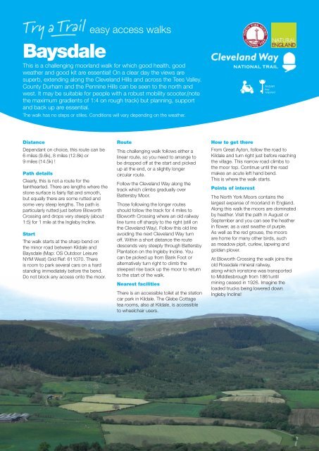
<strong>easy</strong> <strong>access</strong> <strong>walk</strong>s<br />
<strong>Baysdale</strong><br />
This is a challenging moorland <strong>walk</strong> for which good health, good<br />
weather and good kit are essential! On a clear day the views are<br />
superb, extending along the Cleveland Hills and across the Tees Valley.<br />
County Durham and the Pennine Hills can be seen to the north and<br />
west. It may be suitable for people with a robust mobility scooter,(note<br />
the maximum gradients of 1:4 on rough track) but planning, support<br />
and back up are essential.<br />
<strong>The</strong> <strong>walk</strong> has no steps or stiles. Conditions will vary depending on the weather.<br />
RADAR<br />
key<br />
required<br />
Distance<br />
Dependant on choice, this route can be<br />
6 miles (9.6k), 8 miles (12.8k) or<br />
9 miles (14.5k) !<br />
Path details<br />
Clearly, this is not a route for the<br />
fainthearted. <strong>The</strong>re are lengths where the<br />
stone surface is fairly fl at and smooth,<br />
but equally there are some rutted and<br />
some very steep lengths. <strong>The</strong> path is<br />
particularly rutted just before Bloworth<br />
Crossing and drops very steeply (about<br />
1:5) for 1 mile at the Ingleby Incline.<br />
Start<br />
<strong>The</strong> <strong>walk</strong> starts at the sharp bend on<br />
the minor road between Kildale and<br />
<strong>Baysdale</strong> (Map: OS Outdoor Leisure<br />
NYM West) Grid Ref: 611070. <strong>The</strong>re<br />
is room to park several cars on a hard<br />
standing immediately before the bend.<br />
Do not block any <strong>access</strong> onto the moor.<br />
Route<br />
This challenging <strong>walk</strong> follows either a<br />
linear route, so you need to arrange to<br />
be dropped off at the start and picked<br />
up at the end, or a slightly longer<br />
circular route.<br />
Follow the Cleveland Way along the<br />
track which climbs gradually over<br />
Battersby Moor.<br />
Those following the longer routes<br />
should follow the track for 4 miles to<br />
Bloworth Crossing where an old railway<br />
line turns off sharply to the right (still on<br />
the Cleveland Way). Follow this old line<br />
avoiding the next Cleveland Way turn<br />
off. Within a short distance the route<br />
descends very steeply through Battersby<br />
Plantation on the Ingleby Incline. You<br />
can be picked up from Bank Foot or<br />
alternatively turn right to climb the<br />
steepest rise back up the moor to return<br />
to the start of the <strong>walk</strong>.<br />
Nearest facilities<br />
<strong>The</strong>re is an <strong>access</strong>ible toilet at the station<br />
car park in Kildale. <strong>The</strong> Glebe Cottage<br />
tea rooms, also at Kildale, is <strong>access</strong>ible<br />
to wheelchair users.<br />
How to get there<br />
From Great Ayton, follow the road to<br />
Kildale and turn right just before reaching<br />
the village. This narrow road climbs to<br />
the moor top. Continue until the road<br />
makes an acute left hand bend.<br />
This is where the <strong>walk</strong> starts.<br />
Points of interest<br />
<strong>The</strong> North York Moors contains the<br />
largest expanse of moorland in England.<br />
Along this <strong>walk</strong> the moors are dominated<br />
by heather. Visit the path in August or<br />
September and you can see the heather<br />
in fl ower, as a vast swathe of purple.<br />
As well as the red grouse, the moors<br />
are home for many other birds, such<br />
as meadow pipit, curlew, lapwing and<br />
golden plover.<br />
At Bloworth Crossing the <strong>walk</strong> joins the<br />
old Rosedale mineral railway,<br />
along which ironstone was transported<br />
to Middlesbrough from 1861until<br />
mining ceased in 1926. Imagine the<br />
loaded trucks being lowered down<br />
Ingleby Incline!
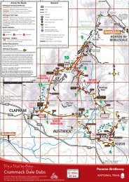
<strong>Baysdale</strong><br />
1 P VP<br />
1:6 max 1:9 ave<br />
2300m<br />
Park off the road and well clear<br />
of gateways.<br />
6<br />
10 G<br />
Continue through the gate and along<br />
the track. <strong>The</strong> gate may need unlocking<br />
with a RADAR key.<br />
From here to Bloworth Crossing the<br />
route is undulating but climbs a total of<br />
over 100 metres. Average gradient is<br />
approximately 1:9 with the maximum<br />
1:6. <strong>The</strong> route follows a track all the way,<br />
but in parts is very rough.<br />
Follow the track signed Cleveland Way<br />
7<br />
11 G<br />
Continue along the level trackway<br />
12<br />
If you have arranged for a transport pick<br />
up, Bank Foot is the place<br />
2<br />
Continue along the track<br />
1:6 max 1:9 ave<br />
3 3700m<br />
At this junction turn left and continue<br />
along the track<br />
4 VP<br />
8<br />
9<br />
13 G<br />
If <strong>walk</strong>ing back to the start of the<br />
complete <strong>walk</strong>, turn right up the short<br />
tarmac road and through the gate.<br />
14 15<br />
1:4 max<br />
1500m<br />
This rough track climbs 170 metres in<br />
1½k<br />
From the cross the route descends a<br />
little towards Bloworth Crossing<br />
16<br />
Rejoin the outward route and turn left to<br />
return to your car.<br />
1<br />
10<br />
12<br />
2<br />
11<br />
13<br />
3<br />
14<br />
5 6<br />
4<br />
Join the old railway track and turn right<br />
7<br />
Do not follow the Cleveland Way to the<br />
left, but continue along the main track<br />
8<br />
15<br />
5<br />
<strong>The</strong> top of Ingleby Incline is a possible<br />
return route. Cut right across the moor<br />
to rejoin the outward route<br />
16<br />
9<br />
1:5<br />
1500m VP<br />
Follow the incline off the moor
<strong>Baysdale</strong><br />
P<br />
KEY<br />
Tarmac road or path<br />
1<br />
VP<br />
Compact hard surface,<br />
occasional stones or gravel<br />
Compact earth/short grass<br />
2<br />
Worn grass<br />
Ruts, stones or long grass<br />
12<br />
G<br />
14<br />
15 16<br />
Rough surface<br />
Continuation of <strong>National</strong> Trail<br />
P<br />
13<br />
G<br />
Gate<br />
P<br />
Parking<br />
S<br />
Seat<br />
I<br />
Information Panel<br />
VP<br />
WC<br />
View Point<br />
Toilets<br />
3<br />
R Refreshments<br />
1 Photo Location<br />
Radar key required<br />
All route photographs are taken in the direction<br />
of travel, unless otherwise stated.<br />
This map is reproduced from Ordnance Survey<br />
digital map data<br />
© Crown copyright 2009. All rights reserved<br />
Licence No. 100021930<br />
© North York Moors <strong>National</strong> Park 2009<br />
G<br />
0<br />
500 1000<br />
Metres<br />
11<br />
G<br />
10<br />
VP<br />
9<br />
8<br />
4<br />
VP<br />
5<br />
7<br />
6