Comprehensive Plan Maps - Town Of Oxford
Comprehensive Plan Maps - Town Of Oxford
Comprehensive Plan Maps - Town Of Oxford

You also want an ePaper? Increase the reach of your titles
YUMPU automatically turns print PDFs into web optimized ePapers that Google loves.
Boone Cr.<br />
Bachelor<br />
Point<br />
BACHELORS POINT RD<br />
MORRIS AVENUE<br />
BMORRIS STREET<br />
<strong>Town</strong> Creek<br />
TRED<br />
EAST STRAND<br />
AVON<br />
RIVER<br />
BOONE<br />
CREEK<br />
RIVERVIEW AVE<br />
BONFIELD MANOR RD<br />
WILLIS ST<br />
FRANKLIN ST<br />
BRADLEY ST<br />
RD<br />
BOONE CREEK<br />
RD<br />
CEMETERY RD<br />
BONFIELD RD<br />
PINEWOOD<br />
Flatty<br />
Cove<br />
ISLAND<br />
RD<br />
EVERGREEN<br />
MD 333<br />
CREEK<br />
HOLLY HARBOR<br />
RD<br />
RD<br />
Goldsborough Cr.<br />
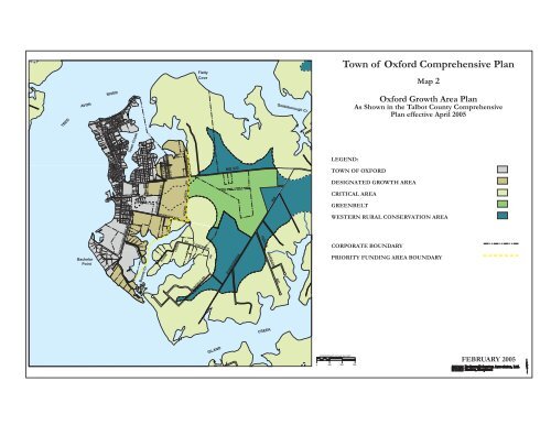
<strong>Town</strong> of <strong>Oxford</strong> <strong>Comprehensive</strong> <strong>Plan</strong><br />
Map 2<br />
<strong>Oxford</strong> Growth Area <strong>Plan</strong><br />
As Shown in the Talbot County <strong>Comprehensive</strong><br />
<strong>Plan</strong> effective April 2005<br />
LEGEND:<br />
TOWN OF OXFORD<br />
DESIGNATED GROWTH AREA<br />
CRITICAL AREA<br />
GREENBELT<br />
WESTERN RURAL CONSERVATION AREA<br />
CORPORATE BOUNDARY<br />
PRIORITY FUNDING AREA BOUNDARY<br />
APPROXIMATE SCALE IN FEET<br />
0 250 500 750<br />
FEBRUARY 2005