Park Brochure - California State Parks
Park Brochure - California State Parks
Park Brochure - California State Parks

You also want an ePaper? Increase the reach of your titles
YUMPU automatically turns print PDFs into web optimized ePapers that Google loves.
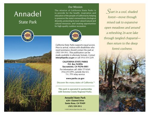
Annadel<br />
<strong>State</strong> <strong>Park</strong><br />
Our Mission<br />
The mission of <strong>California</strong> <strong>State</strong> <strong>Park</strong>s is<br />
to provide for the health, inspiration and<br />
education of the people of <strong>California</strong> by helping<br />
to preserve the state’s extraordinary biological<br />
diversity, protecting its most valued natural and<br />
cultural resources, and creating opportunities<br />
for high-quality outdoor recreation.<br />
<strong>California</strong> <strong>State</strong> <strong>Park</strong>s supports equal access.<br />
Prior to arrival, visitors with disabilities who<br />
need assistance should contact the park at<br />
(707) 539-3911. This publication can be<br />
made available in alternate formats. Contact<br />
interp@parks.ca.gov or call (916) 654-2249.<br />
CALIFORNIA STATE PARKS<br />
P.O. Box 942896<br />
Sacramento, CA 94296-0001<br />
For information call: (800) 777-0369.<br />
(916) 653-6995, outside the U.S.<br />
711, TTY relay service<br />
www.parks.ca.gov<br />
Discover the many states of <strong>California</strong>.<br />
Start in a cool, shaded<br />
forest—move through<br />
mixed oak to expansive<br />
open meadows and around<br />
a refreshing 26-acre lake<br />
through tangled chaparral—<br />
then return to the deep<br />
forest coolness.<br />
This park is operated in partnership<br />
with Sonoma County Regional <strong>Park</strong>s.<br />
Annadel <strong>State</strong> <strong>Park</strong><br />
6201 Channel Drive<br />
Santa Rosa, CA 95409<br />
(707) 539-3911<br />
© 2003 <strong>California</strong> <strong>State</strong> <strong>Park</strong>s (Rev. 2012)
A<br />
nnadel <strong>State</strong> <strong>Park</strong> sits in the historic<br />
Valley of the Moon, an area popularized<br />
by author Jack London. This largely<br />
undeveloped park is 60 miles north of San<br />
Francisco on the eastern edge of Santa<br />
Rosa. The park has more than 5,500 acres<br />
of rolling hills, seasonal streams, meadows<br />
and woodlands free from modern intrusions.<br />
Summers are hot and dry, with<br />
temperatures often in the 90s and evening<br />
lows near 50 degrees. At times during the<br />
summer, coastal fog penetrates inland,<br />
providing cool evenings. Most of the area’s<br />
30 inches of rain occur from November to<br />
April. Wintertime low temperatures can<br />
drop to the mid-20s with daytime highs in<br />
the 50s or 60s.<br />
PARK HISTORY<br />
For thousands of years, the Southern<br />
Pomo lived near what is now the park. No<br />
permanent village sites have been found in<br />
the park, but these lands were important as<br />
trading grounds and as a source of obsidian,<br />
a volcanic rock that was traded with other<br />
tribes, who would work it into scrapers,<br />
knives, arrow points and spearheads.<br />
In the early 1800s, Russian and Aleutian<br />
fur trappers arrived in the area to establish<br />
Fort Ross, now a state historic park. They<br />
found the Pomo willing traders and hard<br />
workers. The Fort Ross settlers may have<br />
been the Pomo’s first contact with nonnative<br />
people. By the mid-1800s, many<br />
native people had been drawn into nearby<br />
Mission San Francisco Solano. Gold rush<br />
miners and settlers who wanted the Pomo<br />
lands forced the Pomo into indentured<br />
servitude (despite <strong>California</strong>’s prohibition<br />
against slavery) or moved them onto<br />
reservations. Though the Pomo resisted<br />
these drastic changes to their way of life,<br />
many succumbed to overwork and to<br />
European diseases to which they had<br />
no resistance.<br />
With the arrival of Europeans, cattle<br />
ranching and farming gradually replaced<br />
the native pattern of hunting and<br />
gathering. By 1837 this area had become<br />
part of Los Guilicos Rancho, a Mexican<br />
land grant covering about 19,000 acres.<br />
Eleven years later, the property was<br />
acquired by William Hood, who came here<br />
from his native Scotland.<br />
In the late 1800s, sheep and cattle grazing<br />
gave way to the quarrying of cobblestones.<br />
This was the major source of income for the<br />
Wymore and Hutchinson families, the area’s<br />
principal landowners, until the early 1900s.<br />
Cobblestones were used in the building of<br />
San Francisco and other west coast cities,<br />
as well as in their reconstruction after the<br />
1906 earthquake. However, cobblestone<br />
roads were not suitable for motor<br />
vehicles, and by the 1920s demand for<br />
them had significantly declined.<br />
In the 1930s, entrepreneur Joe Coney<br />
bought 3,200 acres of oak woodlands<br />
near Santa Rosa from Irish immigrant<br />
Samuel Hutchinson. Hutchinson had<br />
named his ranch by combining the name<br />
of his daughter, Annie, with dell (a small,<br />
secluded, wooded valley). Under the<br />
Coneys’ ownership, it became known<br />
as “the Annadel Farm.” Coney built a<br />
hunting and fishing retreat for his friends.<br />
He stocked the property with game<br />
birds and filled his man-made lake, Lake<br />
Ilsanjo (built in the mid-1950s and named<br />
for the Coney couple, Ilse and Joe), with<br />
black bass and other fish. When his<br />
fortunes began to diminish in the 1960s,<br />
Joe Coney decided to sell the ranch.<br />
<strong>California</strong> <strong>State</strong> <strong>Park</strong>s acquired Annadel in<br />
1971, and it became a state park in 1974.<br />
Ledson Marsh
NATURAL HISTORY<br />
Annadel’s terrain consists of a diverse<br />
range of plant communities, including<br />
meadows, grasslands, forests and<br />
chaparral areas. Environmental conditions<br />
favor the development of these varied<br />
habitats, making it possible to view a wide<br />
variety of birds and animals during a visit.<br />
Deer are commonly seen around sunset,<br />
and coyotes are among the many species<br />
of wildlife here.<br />
RECREATION<br />
Hikers, equestrians, mountain bicyclists,<br />
runners and nature-lovers can choose<br />
among more than 40 miles of trails.<br />
Elevation gains and degree of difficulty<br />
vary with each trail.<br />
Warren Richardson Trail<br />
TRAILS<br />
Warren Richardson Trail (fire road)—<br />
This trail, commemorating a prominent<br />
cattle rancher and hop grower, begins at the<br />
parking lot at the end of Channel Drive and<br />
goes uphill through a forest of Douglas-fir,<br />
bay and redwood trees. Parts of the trail are<br />
home to pileated woodpeckers and pygmy<br />
owls. In the spring, keep an eye out for<br />
calypso (fairy slipper) orchids between the<br />
Two Quarry and Steve’s “S” Trail junction. At<br />
the 900-foot elevation, the forest gives way<br />
to open meadows and mixed oak woodlands,<br />
and you will get your first glimpse of Lake<br />
Ilsanjo when you intersect the North Burma<br />
Trail. The walk generally takes an hour to<br />
cover the 2½ miles to the lake.<br />
Picnic tables are scattered along the<br />
shoreline. Circle the lake and return via<br />
Steve’s “S” Trail to make a 6-mile loop.<br />
Cobblestone Trail—This narrow, 2-mile<br />
trail beginning at the auxiliary parking<br />
area on Channel Drive is rocky on the<br />
bottom third, then flattens as it nears the<br />
boundary of the park. Farther along this<br />
route is the Wymore Quarry. At one time,<br />
a gravity-powered, narrow-gauge tramway<br />
transported the cobblestones produced at<br />
the quarry to a small-gauge railroad line,<br />
which is now Channel Drive. The stones<br />
were then transported to San Francisco<br />
and Sacramento, where some of the oldest<br />
streets are still paved in cobblestones. The<br />
trail ends at Rough-Go Trail.<br />
Spring Creek Trail—There are two access<br />
points to this trail; one is the service road<br />
from Spring Lake’s horse-trailer parking area,<br />
and the other is from Santa Rosa’s Viet<br />
Nam Veterans’ Trail. This trail is completely<br />
shaded by alders, redwoods and arching<br />
bay trees that grow along the creek canyon,<br />
making this one of the most pleasant trails<br />
in the park on a hot summer day. The trail<br />
begins with an increase in elevation and<br />
ends at the lake.<br />
Canyon Trail (fire road)—This 2-mile trail<br />
begins at the intersection of Spring Creek<br />
Trail near a wooden bridge. The trail’s<br />
elevation increases steadily. At the top,<br />
discover a panoramic view of Santa Rosa,<br />
the Mayacamas Mountain Range with the<br />
Geysers, and Mount Saint Helena. Colorful<br />
“Indian warriors” bloom from March through<br />
May at the Marsh Trail intersection. Canyon<br />
Trail ends at the lake after passing by<br />
Hunter Spring, where a horse-watering<br />
trough is located.<br />
Marsh Trail—This trail climbs steadily<br />
from its beginning at the intersection<br />
with Canyon Trail. Marsh Trail skirts the<br />
northern flank of Bennett Mountain. Higher<br />
elevations provide views of Lake Ilsanjo<br />
and the Mayacamas Mountain Range. The<br />
trail runs through prime oak woodlands,<br />
grasslands and cool islands of coastal<br />
redwoods. Threatened <strong>California</strong> redlegged<br />
frogs, popularized by Mark Twain’s<br />
Celebrated Jumping Frog of Calaveras<br />
County, live at Ledson Marsh,<br />
where the trail terminates.<br />
(Please step with care.) The<br />
structures attached to various<br />
trees surrounding the marsh are<br />
nesting boxes for wood ducks.<br />
<strong>California</strong><br />
red-legged frog
North Burma Trail—This route begins a<br />
third of a mile beyond the visitor center<br />
on Channel Drive. Follow a seasonal creek<br />
that receives its water from False Lake<br />
Meadow, a highland vernal pool, before<br />
passing through areas of chaparral and<br />
mixed forests. In the vernal pool near<br />
the Live Oak Trail area, look for tiny, very<br />
rare, white fritillary flowers blooming from<br />
March through May. The trail borders<br />
several meadows and ends at the Warren<br />
Richardson Trail, where there is a wonderful<br />
view of Lake Ilsanjo.<br />
Rough-Go Trail—Try it to see how this<br />
steep, rough path earned its name. The<br />
trail has full southwestern exposure as<br />
it switchbacks past rocks, boulders and<br />
grassland meadows on the way to the lake.<br />
Lawndale Trail—<br />
The trail begins at<br />
the eastern end of<br />
the park off Lawndale<br />
Road from Highway<br />
12 near Kenwood.<br />
Steve’s “S” Trail—<br />
Restricted to hikers<br />
only, the route begins<br />
and ends at the<br />
Warren Richardson<br />
Trail. This steep path<br />
is shaded by firs<br />
and bay trees. The<br />
trail is named for<br />
Steve Hutchinson,<br />
the Hutchinsons’<br />
grandson, who<br />
had his own secret<br />
pathways throughout<br />
the ranch; the “S” is for secret. Hikers will walk<br />
over a large area of obsidian chips, which was an<br />
important resource for the native Pomo. (Please<br />
do not collect<br />
any minerals or<br />
other finds.)<br />
Channel Trail—This<br />
trail starts just past<br />
the visitor center on<br />
Channel Drive and<br />
ends at the main<br />
parking lot. About<br />
three-fourths of the<br />
way on the trail,<br />
hikers must exit the<br />
trail and go along<br />
the asphalt Channel<br />
Mayacamas Range in the distance<br />
Drive for a very short distance before<br />
returning to the dirt trail. This area was<br />
one of many quarry sites that are located<br />
in Annadel.<br />
OTHER FEATURES<br />
Lake Ilsanjo—This man-made, 26-acre<br />
lake is not stocked, but bluegill and<br />
largemouth bass live here. All anglers 16<br />
years of age or older must carry a valid<br />
<strong>California</strong> fishing license. Visit the site at<br />
www.dfg.ca.gov for fishing regulations.<br />
Ledson Marsh—First built as a reservoir<br />
to water eucalyptus trees, the marsh<br />
is now mostly overgrown with cattails,<br />
tules and native grasses. During the<br />
winter months, water collects here and<br />
overflows into Schultz Canyon. The bridge<br />
at this spillway helps to protect the rare<br />
<strong>California</strong> red-legged frog.<br />
ACCESSIBLE FEATURES<br />
Two accessible picnic tables sit on a firm<br />
surface under a tree off the main parking<br />
lot at the end of Channel<br />
Drive. An accessible<br />
portable restroom is<br />
nearby, and the parking<br />
lot has designated<br />
accessible parking.<br />
The packed dirt lot<br />
and the paths to the<br />
restroom and tables are<br />
generally accessible.<br />
Accessibility is<br />
continually improving.<br />
For updates, visit<br />
http://access.parks.ca.gov.<br />
Warren Richardson horse trough
PLEASE REMEMBER<br />
• Annadel <strong>State</strong> <strong>Park</strong> is a day-use park<br />
only, open from sunrise to sunset.<br />
• Payment of a fee is required to park<br />
beyond the visitor center.<br />
• Motorized vehicles are allowed only<br />
on Channel Drive, the park’s entrance<br />
road, and the parking lot.<br />
• Except for service animals, dogs are<br />
not allowed in the park.<br />
• Drinkable water is located near the<br />
visitor center and in the main parking<br />
lot at the east end of Channel Drive.<br />
No other water in the park is potable.<br />
• By law, bicycle riders and passengers<br />
younger than 18 years of age must wear<br />
approved helmets.<br />
• Open fires, camp stoves and<br />
barbeques are not allowed.<br />
• Camping is not permitted. Camping<br />
may be available at Spring Lake<br />
County <strong>Park</strong>, which adjoins Annadel<br />
<strong>State</strong> <strong>Park</strong> to the west, and at Sugarloaf<br />
Ridge <strong>State</strong> <strong>Park</strong>, about 6 miles east,<br />
up Adobe Canyon Road.<br />
• A fishing license is required.<br />
• No lifeguards are on duty.<br />
• All natural and cultural features are<br />
protected by law and may not be<br />
disturbed nor removed.<br />
Bicycles and Horses<br />
Please observe these rules:<br />
• Horses and bicycles are restricted to<br />
designated, named trails only. No riding<br />
off trails, on “short cuts,” on unnamed trails<br />
or trailblazing.<br />
• All trail users must yield to horses.<br />
• Some named trails may be posted for “no<br />
use” by horses and/or bicycles.<br />
• Maximum speed is 15 mph.<br />
• Alert trail users ahead of you of<br />
your approach.<br />
NEARBY STATE PARKS<br />
• Sugarloaf Ridge <strong>State</strong> <strong>Park</strong><br />
2605 Adobe Canyon Road,<br />
Kenwood 95452. Camping is available.<br />
(707) 833-5712<br />
• Jack London <strong>State</strong> Historic <strong>Park</strong><br />
2400 London Ranch Road<br />
Glen Ellen 92345<br />
(707) 938-5216<br />
• Sonoma <strong>State</strong> Historic <strong>Park</strong><br />
363 Third St. West, Sonoma 95476<br />
(707) 938-9560<br />
• Petaluma Adobe <strong>State</strong> Historic <strong>Park</strong><br />
3325 Adobe Road, Petaluma 94954<br />
(707) 762-4871<br />
This park is supported in part<br />
through the nonprofit:<br />
Valley of the Moon Natural History Assn.<br />
c/o Jack London <strong>State</strong> Historic <strong>Park</strong><br />
2400 London Ranch Road<br />
Glen Ellen, CA 95442<br />
www.jacklondonpark.com
Trail Information<br />
Trail Name<br />
Length<br />
(miles)<br />
Elevation (feet)<br />
low to high points<br />
Elevation (feet)<br />
gained/lost<br />
Warren Richardson Trail 2.5 390 to 983 +593/-225<br />
Cobblestone Trail 2.0 321 to 833 +592/-63<br />
Spring Creek Trail 1.2+ 415 to 751 +415/-79<br />
Canyon Trail 2.0 334 to 788 +466/-50<br />
Marsh Trail 4.3 797 to 1,320 +709/-171<br />
North Burma Trail 1.7 367 to 946 +579/-0<br />
Rough-Go Trail 2.1 369 to 751 +483/-101<br />
Lawndale Trail 2.9 482 to 1236 +815/-99<br />
Steve’s “S” Trail .8 390 to 879 +489/-15<br />
Channel Trail 1.1 344 to 390 +53/-7