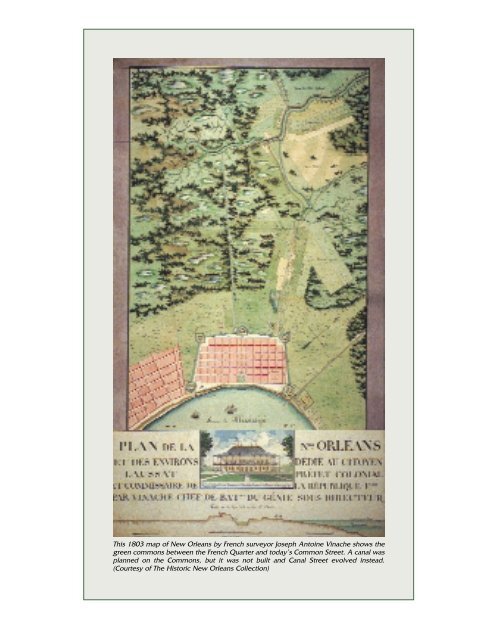
This 1803 map of New Orleans by French - Pelican Publishing ...
This 1803 map of New Orleans by French - Pelican Publishing ...
This 1803 map of New Orleans by French - Pelican Publishing ...

You also want an ePaper? Increase the reach of your titles
YUMPU automatically turns print PDFs into web optimized ePapers that Google loves.
<strong>This</strong> <strong>1803</strong> <strong>map</strong> <strong>of</strong> <strong>New</strong> <strong>Orleans</strong> <strong>by</strong> <strong>French</strong> surveyor Joseph Antoine Vinache shows the<br />
green commons between the <strong>French</strong> Quarter and today’s Common Street. A canal was<br />
planned on the Commons, but it was not built and Canal Street evolved instead.<br />
(Courtesy <strong>of</strong> The Historic <strong>New</strong> <strong>Orleans</strong> Collection)
CHAPTER ONE<br />
The Early Days<br />
<br />
Jacques Tanesse in 1810 subdivided<br />
the City Commons, shown here on an<br />
1812 <strong>map</strong> <strong>of</strong> <strong>New</strong> <strong>Orleans</strong>. The canal<br />
was planned where Canal Street<br />
eventually would be established.<br />
(Courtesy <strong>of</strong> The Historic <strong>New</strong><br />
<strong>Orleans</strong> Collection)<br />
CANAL STREET WAS born—but not in name—in 1807, and in a sense<br />
was an outgrowth <strong>of</strong> the <strong>1803</strong> Louisiana Purchase. A wide space called<br />
the Commune de la Ville, or the City Commons, surrounded the<br />
<strong>French</strong> Quarter and also separated the Quarter from Faubourg St. Mary,<br />
the city’s oldest suburb, which was established in 1788 and today is the<br />
city’s Central Business District. The<br />
Commons was European Crown land<br />
where there had been an earth and<br />
timber palisade and five forts to protect<br />
the city.<br />
The five forts were Fort St. Charles,<br />
near the Mississippi River and modern<br />
Esplanade Avenue, Fort St. John, near<br />
Esplanade and North Rampart Street,<br />
Fort St. Ferdinand, at Congo Square<br />
in front <strong>of</strong> the modern Morris F. X.<br />
Jeff Auditorium, Fort Bourgoyne, near<br />
the intersection <strong>of</strong> Canal Street and<br />
North Rampart Street, and Fort St.<br />
Louis, near Canal and Tchoupitoulas<br />
streets.<br />
With the Louisiana Purchase <strong>of</strong><br />
<strong>1803</strong>, the Crown property went to the<br />
United States government. In 1806<br />
the land was given to <strong>French</strong> nobleman<br />
the Marquis de la Fayette, <strong>of</strong><br />
American Revolutionary War fame.<br />
But when <strong>New</strong> <strong>Orleans</strong> objected, the<br />
United States ceded the land to the<br />
city with the stipulation that a navigation<br />
canal be constructed along part <strong>of</strong><br />
the land to connect the Mississippi<br />
River and Lake Pontchartrain.<br />
A plan was drawn up <strong>by</strong> city surveyor<br />
Jacques Tanesse, dated April 15,<br />
1809, and titled rather lengthily<br />
MARK TWAIN, FROM LIFE<br />
ON THE MISSISSIPPI (1883)<br />
From Chapter 41, “The Metropolis<br />
<strong>of</strong> the South,” on visiting <strong>New</strong><br />
<strong>Orleans</strong> in the late 1850s:<br />
“Canal Street was finer, and<br />
more attractive and stirring than<br />
formerly, with its drifting crowds<br />
<strong>of</strong> people, its several processions <strong>of</strong><br />
hurrying street-cars and—toward<br />
evening—its broad second-story<br />
verandas crowded with gentlemen<br />
and ladies clothed according to<br />
the latest mode.”<br />
21
22 CANAL STREET<br />
<strong>This</strong> view <strong>of</strong> the Canal Street shopping district on a summer day in 1952 <strong>by</strong> Charles L.<br />
Franck Photographers clearly shows the great expanse <strong>of</strong> the proposed canal route.<br />
(Courtesy <strong>of</strong> The Historic <strong>New</strong> <strong>Orleans</strong> Collection)<br />
Plan drawn up in execution <strong>of</strong> the decree <strong>of</strong> the City Council <strong>of</strong><br />
<strong>New</strong> <strong>Orleans</strong> approved <strong>by</strong> the mayor the 15 June 1807, relative to<br />
the six hundred yards <strong>of</strong> its Commons, starting from its fortifications<br />
on all sides, on which a right <strong>of</strong> ownership has been recognized<br />
to the said city <strong>by</strong> the United States.<br />
Soon after, all <strong>of</strong> the fortifications except Fort St. Charles were<br />
removed, and in 1810 Tanesse began subdividing the Commons that<br />
included Esplanade Avenue and North Rampart Street.<br />
On the upriver side <strong>of</strong> the Commons Tanesse set aside space for a<br />
fifty-foot-wide waterway flanked <strong>by</strong> two sixty-foot-wide roadways. <strong>This</strong><br />
was a total width <strong>of</strong> 170 feet, only one foot less than the width <strong>of</strong> modern<br />
Canal Street. The canal to the lake was not designed as a straight line,<br />
but rather extended out from the river levee to what is now Basin Street.<br />
At that point it would turn at a right angle to join the basin <strong>of</strong> the<br />
Carondelet Canal, later called the Old Basin Canal, which had been<br />
built in the 1790s. <strong>This</strong> canal ran along what is now Lafitte Street. It<br />
intersected with the tip <strong>of</strong> Bayou St. John, which ultimately led to Lake<br />
Pontchartrain. The Carondelet Canal was not designed to actually intersect<br />
with the waters <strong>of</strong> the Mississippi since that would have produced a<br />
serious river flooding problem.<br />
The <strong>Orleans</strong> Navigation Company was established to finance and construct<br />
what was deemed a nationally important transportation route<br />
reflecting the monumental importance <strong>of</strong> the Mississippi River at the<br />
time. Lake Pontchartain and Bayou St. John had formed a major route to<br />
the city from the Gulf <strong>of</strong> Mexico, and a navigation canal between the river<br />
and the lake had long been a dream. <strong>This</strong> dream would have to wait, since<br />
the proposed navigation canal on Tanesse’s plan was not carried out.<br />
There were some canals connecting the river and the lakes such as the
The Early Days 23<br />
Lake Borgne Canal <strong>of</strong> the 1840s in St. Bernard Parish. But a large-scale<br />
navigation canal did not materialize until 1923 when the Inner Harbor<br />
Navigation Canal, better known as the Industrial Canal, was dedicated.<br />
At first Canal Street grew slowly on its path to becoming the heart <strong>of</strong><br />
commercial <strong>New</strong> <strong>Orleans</strong>. In its earliest years after the Commons was<br />
subdivided, the street was virtually in the country, with buildings along<br />
its route widely scattered except for a concentration near the river at<br />
Tchoupitoulas and Levee (Decatur) streets—which was then the<br />
Mississippi riverfront.<br />
The character <strong>of</strong> the modern business portion <strong>of</strong> Canal Street—between<br />
the river and Claiborne Avenue—has gone through several distinct periods<br />
<strong>of</strong> change, change representing not only the growing wealth and importance<br />
<strong>of</strong> the street, but nearly two centuries <strong>of</strong> architectural fashion.<br />
A late-1850s bird’s-eye view <strong>of</strong> Canal Street <strong>by</strong> Jay Dearborn Edwards from the top <strong>of</strong><br />
the United States Custom House. The median was still undeveloped, although <strong>by</strong> the<br />
end <strong>of</strong> the decade funds from the estate <strong>of</strong> Judah Touro would pay for the street’s beautification.<br />
(Courtesy <strong>of</strong> The Historic <strong>New</strong> <strong>Orleans</strong> Collection)
24 CANAL STREET<br />
By the 1840s and 1850s, Canal Street was lined with rows <strong>of</strong> low-rise<br />
three- and four-story buildings. By the 1870s, buildings had more ornamentation,<br />
such as elaborate ro<strong>of</strong>lines with spires and cupolas. In the late<br />
1880s, early “skyscrapers” such as the Morris, long known as the Cigali<br />
Building, rose to seven stories. After that, progressively taller buildings<br />
such as the 1902 Imperial Building (Godchaux’s Clothing Store until the<br />
1980s) and the 1909 Maison Blanche structure would further raise the<br />
street’s skyline. With a few exceptions, Canal Street’s panorama would<br />
remain relatively unaltered until the decades after the 1960s when real<br />
skyscrapers made their appearance at the river end <strong>of</strong> the street.<br />
Today, several buildings survive from the 1820s and 1830s, and these<br />
give us an impression <strong>of</strong> what the street would have once looked like. The<br />
oldest building on the street stretches between Decatur Street and Dorsiere<br />
Place. Dating from 1821, it is typical <strong>of</strong> many buildings at the time, since<br />
it served both commercial and residential purposes, although it was<br />
remodeled to its present look in 1899 and is now the home <strong>of</strong> a Wendy’s<br />
fast-food restaurant. At the corner <strong>of</strong> Royal Street are three matching stone<br />
buildings built in 1825 <strong>by</strong> Germain Musson, grandfather <strong>of</strong> <strong>French</strong><br />
Impressionist painter Edgar Degas. These are among the earliest large commercial<br />
structures on the street.<br />
Directly across Canal Street from the Musson Buildings at the corner<br />
<strong>of</strong> St. Charles Street is one <strong>of</strong> the remaining structures <strong>of</strong> what was built<br />
as a row <strong>of</strong> three buildings in 1833. It is typical <strong>of</strong> small commercial<br />
buildings built on Canal Street at the time. For many years it has housed<br />
part <strong>of</strong> Rubenstein Brothers clothing store. <strong>This</strong> fine store is a complex<br />
<strong>of</strong> fine old commercial buildings whose facades above the ground floors<br />
have barely changed since the late nineteenth century.<br />
Beyond Royal Street, Canal became progressively more residential<br />
Marie Adrien Persac’s 1873 drawing <strong>of</strong> Canal Street between Decatur and Chartres<br />
shows the oldest building on the street at the far right prior to its 1899 restoration. The<br />
area at the left is now occupied <strong>by</strong> the Marriott Hotel. (Courtesy <strong>of</strong> The Historic <strong>New</strong><br />
<strong>Orleans</strong> Collection)
The oldest still-standing building on Canal Street, seen here during World War I, is at the<br />
corner <strong>of</strong> Decatur. The building, which dates from the 1820s, was remodeled in 1899 and<br />
now houses a Wendy’s Restaurant. (Courtesy <strong>of</strong> The Historic <strong>New</strong> <strong>Orleans</strong> Collection)<br />
<strong>This</strong> 1873 Marie Adrien Persac’s drawing <strong>of</strong> Canal Street between Chartres and Royal, with<br />
Exchange Place between, shows what is today one <strong>of</strong> the least-changed blocks on the<br />
street. The still-standing buildings owned <strong>by</strong> Edgar Degas’ relatives, the Musson family,<br />
are visible at the left at Royal Street. (Courtesy <strong>of</strong> The Historic <strong>New</strong> <strong>Orleans</strong> Collection)
26 CANAL STREET<br />
One <strong>of</strong> the few buildings from the<br />
1840s that still stands was built for<br />
<strong>New</strong>ton Mercer, a physician, as his residence.<br />
Today it is the home <strong>of</strong> the<br />
Boston Club. (Courtesy <strong>of</strong> The Historic<br />
<strong>New</strong> <strong>Orleans</strong> Collection)<br />
about the 1830s as it witnessed the<br />
construction <strong>of</strong> some <strong>of</strong> the city’s<br />
finer townhouses. In the heart <strong>of</strong><br />
Canal Street is one <strong>of</strong> its finest midnineteenth<br />
century townhouses still<br />
standing. It is now the home <strong>of</strong> the<br />
Boston Club, a private men’s club<br />
that has been there since 1884. The<br />
club took its name from a card game.<br />
The house and side garden remain<br />
hardly changed from when they were<br />
built in the 1840s for Dr. <strong>New</strong>ton<br />
Mercer.<br />
At one time the block between<br />
University Place and South<br />
Rampart Street was lined with opulent<br />
townhouses. The most notable<br />
mansion and garden on the block<br />
were built in 1856 for F. W. Tilton<br />
at the corner <strong>of</strong> University Place.<br />
The grand house became the Shakespeare Literary and Theatrical Club<br />
<strong>by</strong> 1873; <strong>by</strong> 1900, however, the house was no longer standing.<br />
Beginning in the 1840s, additional grandly proportioned townhouses<br />
were appearing on Canal Street beyond Rampart Street alongside more<br />
modest rows <strong>of</strong> houses. By the early twentieth century, many <strong>of</strong> these<br />
houses had become tenements, although the buildings still remained<br />
recognizable. Today, only a handful <strong>of</strong> the buildings are standing. and<br />
they have become so neglected under the guise <strong>of</strong> commercial alterations<br />
and signage that they are hardly recognizable.<br />
Separating the two roadways <strong>of</strong> Canal Street and the quaintness <strong>of</strong><br />
the <strong>French</strong> Quarter and dynamism <strong>of</strong> the business district is the median,<br />
which is locally called the “neutral ground.” Indeed, the term has<br />
come to define every median in the area. Initially the term meant a<br />
common ground, a dividing line between the <strong>French</strong>-speaking Creole<br />
natives and the newly arrived Americans. By the mid-nineteenth century,<br />
Orleanians <strong>of</strong> all classes and backgrounds gathered on Canal Street to<br />
shop, do business, and transfer from one streetcar line to another—thus,<br />
this was the “neutral ground” for all <strong>New</strong> Orleanians.<br />
Outside the business district, as the street developed, street names<br />
were given a north and south designation. But downtown Canal Street<br />
became the great gathering place and center <strong>of</strong> activity in <strong>New</strong> <strong>Orleans</strong>.<br />
With all manner <strong>of</strong> events occurring on the thoroughfare, it became the<br />
equivalent <strong>of</strong> Times Square in <strong>New</strong> York or Piccadilly Circus in London.<br />
As large stores proliferated along Canal Street in the 1850s and streetcar<br />
lines terminated there, people gravitated more and more to its confines.<br />
Because <strong>of</strong> its great width, it could accommodate larger crowds<br />
than most other main streets. Canal Street has been called America’s<br />
widest main street, and while some towns, including Augusta, Georgia,<br />
have disputed this, few big cities have a main street that is as wide as<br />
some entire city blocks.
The Early Days 27<br />
The largest building on early Canal Street was Charity Hospital,<br />
which was built in 1815 between Baronne Street and University Place.<br />
In 1832 the hospital moved to new quarters on Common, now Tulane<br />
Avenue. The state capitol was moved into the former hospital building.<br />
In 1815 the building was still considered “in the country,” but <strong>by</strong> the<br />
1830s the fast-growing city was quickly expanding around it.<br />
In 1834 traveler Joseph Holt Ingraham wrote <strong>of</strong> the statehouse:<br />
Its snow-white front, though plain, is very imposing; and the whole<br />
structure with its handsome, detached wings, and large green<br />
[lawn], thickly covered with shrubbery in front, luxuriant with<br />
orange and lemon trees, presents decidedly, one <strong>of</strong> the finest views<br />
to be met with in the city.<br />
Ingraham went on to describe the rest <strong>of</strong> the Canal Street “with its<br />
triple row <strong>of</strong> young sycamores, extending through out the whole<br />
length,” as<br />
one <strong>of</strong> the most spacious, and destined at no distant period to be<br />
one <strong>of</strong> the first and handsomest streets <strong>of</strong> the city. Every building in<br />
the street is <strong>of</strong> modern construction, and some blocks <strong>of</strong> its brick<br />
edifices will vie in tasteful elegance with the boasted granite piles <strong>of</strong><br />
Boston.<br />
The street, though wide, was not long, and Ingraham wrote that “this<br />
street, which less than a mile from the river terminates in the swampy<br />
commons, every where surrounding<br />
<strong>New</strong> <strong>Orleans</strong>, except<br />
the river side.” Thus, he<br />
described Canal Street as disappearing<br />
into the swamps<br />
somewhere around Claiborne<br />
Avenue. Ultimately, the street<br />
would extend almost 3 1 /2 miles,<br />
with its terminus, quite appropriately,<br />
in front <strong>of</strong> a grouping<br />
<strong>of</strong> cemeteries.<br />
The state legislature moved<br />
from <strong>New</strong> <strong>Orleans</strong> to<br />
Donaldsonville, and then to<br />
Baton Rouge in the late<br />
1840s, and the elegant capitol<br />
The Custom House as it appeared in the early<br />
1800s. <strong>This</strong> is one <strong>of</strong> three Custom House<br />
buildings, each larger than its predecessor,<br />
that has occupied the site. (Courtesy <strong>of</strong> The<br />
Historic <strong>New</strong> <strong>Orleans</strong> Collection)<br />
Ingraham described—then<br />
only about thirty-five years<br />
old and surrounded <strong>by</strong> the<br />
fast growing city—was sold<br />
and demolished. The block on<br />
which it stood was quickly<br />
covered with a mixture <strong>of</strong> residences<br />
and commercial<br />
establishments, but within a<br />
short time, commerce would
28 CANAL STREET<br />
come to absorb the entire block. As with the rest <strong>of</strong> Canal Street’s commercial<br />
heart, once business took hold the former residential character<br />
never returned.<br />
Established in 1805, Christ Episcopal Church is the oldest Protestant<br />
congregation in Louisiana, and for about eighty years the church called<br />
Canal Street home. The congregation worshiped in several locations,<br />
including the Cabildo. In 1816, it moved into an octagonal brick building<br />
designed <strong>by</strong> Henry S. Latrobe, son <strong>of</strong> the famous English-born architect<br />
<strong>of</strong> the first United States capitol, Benjamin Latrobe, on the river side<br />
<strong>of</strong> Bourbon Street.<br />
By the 1830s the congregation had outgrown its small church, and in<br />
1837 a new one was built on the same site. Designed <strong>by</strong> James Dakin and<br />
James Gallier, Sr. with a row <strong>of</strong> six Ionic columns and no steeple, it resembled<br />
nothing more than a Greek temple. It survived less than ten years,<br />
since in 1846 a new Christ Church was built on the lakeside corner <strong>of</strong><br />
View <strong>of</strong> Canal Street looking toward Lake Pontchartrain from Bourbon in the late 1850s,<br />
<strong>by</strong> Jay Dearborn Edwards. The steeple <strong>of</strong> Christ Episcopal Church is at the right.<br />
(Courtesy <strong>of</strong> The Historic <strong>New</strong> <strong>Orleans</strong> Collection)
The Early Days 29<br />
Canal Steet in 1866. (Photo <strong>by</strong> Theodore<br />
Lilienthal; courtesy <strong>of</strong> the Louisiana State<br />
Museum)<br />
Dauphine Street. It was designed<br />
<strong>by</strong> Thomas K. Wharton and built<br />
<strong>by</strong> James Gallier, Sr. in the<br />
Gothic style, which was regarded<br />
as more fitting for an Episcopal<br />
house <strong>of</strong> worship. For nearly four<br />
decades Christ Church dominated<br />
the skyline <strong>of</strong> Canal Street as<br />
the street’s tallest structure.<br />
In 1887 the church building—<br />
just about forty years old—was<br />
demolished after the congregation<br />
moved to its current home<br />
on St. Charles Avenue at Sixth<br />
Street. Its replacement was the<br />
ornate Mercier Building, which<br />
Canal Street between Dauphine and Burgundy in 1873. Shown are Christ Episcopal<br />
Church and Union Terrace, to the left <strong>of</strong> the church. Later, Maison Blanche Department<br />
Store occupied most <strong>of</strong> the block. Today, the Ritz-Carlton Hotel and the Audubon<br />
Building fill the block. <strong>This</strong> is one <strong>of</strong> twenty detailed block elevations <strong>of</strong> Canal Street <strong>by</strong><br />
Marie Adrien Persac. (Courtesy <strong>of</strong> The Historic <strong>New</strong> <strong>Orleans</strong> Collection)
30 CANAL STREET<br />
During the late nineteenth century, many grandiose buildings appeared on Canal<br />
Street. The Crescent Brewery, on the downtown corner <strong>of</strong> North Claiborne and Canal<br />
Street, became a candy factory during Prohibition.<br />
became the first home <strong>of</strong> Maison Blanche Department Store in 1897.<br />
Commerce had truly come to dominate this portion <strong>of</strong> Canal Street.<br />
The distinctive golden beehive corner dome <strong>of</strong> this building would<br />
dominate the corner <strong>of</strong> Canal and Dauphine for only about thirty<br />
years—there was no preservation movement then. Around 1908 it was<br />
torn down for a new Maison Blanche “skyscraper” store and <strong>of</strong>fice building<br />
that still stands on the site as the Ritz-Carlton Hotel.