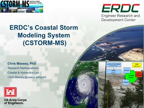
ERDC's Coastal Storm Modeling System (CSTORM-MS)
ERDC's Coastal Storm Modeling System (CSTORM-MS)
ERDC's Coastal Storm Modeling System (CSTORM-MS)

Create successful ePaper yourself
Turn your PDF publications into a flip-book with our unique Google optimized e-Paper software.
ERDC’s <strong>Coastal</strong> <strong>Storm</strong><br />
<strong>Modeling</strong> <strong>System</strong><br />
(<strong>CSTORM</strong>-<strong>MS</strong>)<br />
Chris Massey, PhD<br />
Research Mathematician<br />
<strong>Coastal</strong> & Hydraulics Lab<br />
Chris.Massey@usace.army.mil
ERDC’s <strong>Coastal</strong> <strong>Storm</strong>-<strong>Modeling</strong> <strong>System</strong><br />
(ERDC <strong>CSTORM</strong>-<strong>MS</strong>)<br />
Application of high-resolution, highly skilled numerical models in<br />
a tightly integrated modeling system with user friendly interfaces<br />
Not just<br />
hurricanes and<br />
not just in the<br />
Gulf of Mexico.<br />
Expandable and<br />
upgradeable system.<br />
Next Generation Workflow<br />
Provides for a robust, standardized approach to establishing the risk<br />
of coastal communities to future occurrences of storm events.<br />
BUILDING STRONG ®<br />
Innovative solutions for a safer, better world<br />
Chris.Massey@usace.army.mil<br />
2
<strong>CSTORM</strong>-<strong>MS</strong> Spiral 1<br />
• Substantial advances in the state of the art have been made and<br />
these have played a critical role in supporting ERDC Action 2d of the<br />
USACE Campaign Plan<br />
• The applications of <strong>CSTORM</strong>-<strong>MS</strong> technology prior to 2010 had been<br />
“softly” coupled with individual applications made by specialists<br />
combining codes<br />
• <strong>CSTORM</strong>-<strong>MS</strong> implements advances into a “tightly” coupled, more<br />
efficient user-system for applications and includes GUIs within the<br />
S<strong>MS</strong><br />
• Individual and coupled models can be applied stand alone on either<br />
an HPC or a desktop PC.<br />
BUILDING STRONG ®<br />
Innovative solutions for a safer, better world<br />
Chris.Massey@usace.army.mil
<strong>CSTORM</strong>-<strong>MS</strong> Technology<br />
Applications<br />
• Loose Model Coupling (Prior to 2009)<br />
− Interagency Performance Evaluation Task Force (IPET)<br />
− Louisiana <strong>Coastal</strong> Protection and Restoration (LaCPR - MVN)<br />
− Mississippi <strong>Coastal</strong> Improvement Program (MsCIP - SAM)<br />
− Flood mapping for Texas, Louisiana, Mississippi, North Carolina, Chesapeake Bay (FEMA)<br />
− Morganza to the Gulf Hurricane Protection Project (MVN)<br />
− Inner Harbor Navigation Canal (IHNC) closure (MVN)<br />
− Plaquemines Parish flood protection planning (Plaquemines Parish)<br />
− Guidance for new “PMH” coastal surge estimates for licensing (Nuclear Regulatory Commission)<br />
− Waves inside Harbor Mouths (POA)<br />
− Ongoing New Orleans Litigation (Department of Justice)<br />
− New wave model evaluation technique (NOAA)<br />
• Tight Model Coupling (Alpha Version)<br />
– Finished in the Fall of 2009<br />
– ERDC users for Corps projects (MsCIP and LaRose)<br />
• ERDC-OWI-PBL Model<br />
– Finished in the Summer of 2009<br />
– ERDC users for Corps projects (MsCIP and LaRose)<br />
– ERDC users for Nuclear Regulatory Commission project<br />
• Tight Model Coupling (<strong>CSTORM</strong>-<strong>MS</strong>) – { Requires far fewer processors than Alpha Version }<br />
– Finished in June of 2010<br />
– ERDC users for Nuclear Regulatory Commission project<br />
• ESMF Compliant STWAVE Wave Model<br />
– Finished in the Fall of 2009<br />
– ERDC users for Corps projects (MsCIP and LaRose)<br />
BUILDING – Evaluated STRONG ® by contractors for FEMA flood mapping projects<br />
Chris.Massey@usace.army.mil<br />
Innovative solutions for a safer, better world
Spiral 1 <strong>System</strong> Components<br />
• Winds/Pressure: PBL Cyclone Model<br />
• Waves:<br />
► Regional: WAM<br />
► Nearshore: STWAVE*<br />
• Circulation/Surge: ADCIRC*<br />
• Coupling Framework: <strong>CSTORM</strong>-<strong>MS</strong>*<br />
(*ESMF Compliant)<br />
Winds + Waves + Surge<br />
BUILDING STRONG ®<br />
Chris.Massey@usace.army.mil<br />
5<br />
Innovative solutions for a safer, better world
Example Model Domains<br />
United States<br />
Gulf of<br />
Mexico<br />
Atlantic<br />
Ocean<br />
‣ ADCIRC grid boundaries<br />
are shown in black<br />
‣ PBL/WAM grid<br />
boundaries are shown in<br />
red<br />
‣ STWAVE grid boundaries<br />
are shown in blue<br />
BUILDING STRONG ®<br />
Innovative solutions for a safer, better world<br />
Chris Massey USACE-ERDC-CHL
Example STWAVE Grids<br />
200 m x 200 m grid resolution<br />
BUILDING STRONG ®<br />
Innovative solutions for a safer, better world<br />
Chris Massey USACE-ERDC-CHL
Example ADCIRC Unstructured Mesh<br />
The mesh consists of<br />
approximately 5.4 million<br />
elements and 2.7 million<br />
nodes.<br />
Mesh resolution<br />
From 28 km down to 23 m<br />
Approximately<br />
98% of all<br />
elements are<br />
in the study<br />
area.<br />
BUILDING STRONG ®<br />
Innovative solutions for a safer, better world<br />
Chris Massey USACE-ERDC-CHL
SL15 Mesh Resolution<br />
BUILDING STRONG ®<br />
Chris Massey USACE-ERDC-CHL<br />
9<br />
Innovative solutions for a safer, better world
SL15 Mesh Resolution<br />
BUILDING STRONG ®<br />
Chris Massey USACE-ERDC-CHL<br />
10<br />
Innovative solutions for a safer, better world
SL15 Mesh Resolution<br />
BUILDING STRONG ®<br />
Chris Massey USACE-ERDC-CHL<br />
11<br />
Innovative solutions for a safer, better world
SL15 Mesh Resolution<br />
BUILDING STRONG ®<br />
Chris Massey USACE-ERDC-CHL<br />
12<br />
Innovative solutions for a safer, better world
(Courtesy of Dr. Rick Luettich)<br />
Higher vs Lower Resolution Grids<br />
424,485<br />
nodes<br />
Inter-grid<br />
comparison<br />
9,288,245<br />
nodes<br />
BUILDING STRONG ®<br />
Innovative solutions for a safer, better world<br />
Chris Massey USACE-ERDC-CHL
Inter-Grid Comparison Hurricane Ike<br />
(Courtesy of Dr. Rick Luettich)<br />
Water Level (m)<br />
Hi-res<br />
WET<br />
ONLY<br />
Low-res<br />
WET<br />
ONLY<br />
BUILDING STRONG ®<br />
Innovative solutions for a safer, better world<br />
Chris Massey USACE-ERDC-CHL
Topo/Bathy Comparisons<br />
for a Site in South FL<br />
NGDC Data<br />
Lidar Data<br />
BUILDING STRONG ®<br />
Innovative solutions for a safer, better world<br />
Chris Massey USACE-ERDC-CHL
Topo/Bathy Comparisons for a Site in<br />
South FL<br />
BUILDING STRONG ®<br />
Innovative solutions for a safer, better world<br />
Chris Massey USACE-ERDC-CHL
Topo/Bathy Comparisons for a Site in<br />
South FL<br />
BUILDING STRONG ®<br />
Innovative solutions for a safer, better world<br />
Chris Massey USACE-ERDC-CHL
Topo/Bathy Comparisons for a Site in<br />
South FL<br />
BUILDING STRONG ®<br />
Innovative solutions for a safer, better world<br />
Chris Massey USACE-ERDC-CHL
Topo/Bathy Comparisons for a Site in<br />
South FL<br />
BUILDING STRONG ®<br />
Innovative solutions for a safer, better world<br />
Chris Massey USACE-ERDC-CHL
Topo/Bathy Comparisons for a Site in<br />
South FL<br />
BUILDING STRONG ®<br />
Innovative solutions for a safer, better world<br />
Chris Massey USACE-ERDC-CHL
<strong>Storm</strong> Tracks – Eastern LA & <strong>MS</strong><br />
BUILDING STRONG ®<br />
Chris Massey USACE-ERDC-CHL<br />
21<br />
Innovative solutions for a safer, better world
<strong>Storm</strong> Parameters applied in JPM-OS<br />
Forward Speed<br />
V f2<br />
V f3<br />
V f1<br />
R p<br />
R p<br />
R p<br />
C p<br />
Track<br />
θ 1<br />
C p<br />
θ 2<br />
θ 3<br />
Track 1 Track 2 Track 3<br />
For any location…..<br />
each red box (parameter set) has a joint probability density and a response (surge).<br />
C p<br />
BUILDING STRONG ®<br />
Innovative solutions for a safer, better world<br />
Chris Massey USACE-ERDC-CHL
MORPHOS-PBL Cyclone Wind<br />
Model<br />
• The wind model being used is an updated<br />
version of the TC96 PBL (Planetary Boundary<br />
Layer) model<br />
► Updated physics (Oceanweather, Inc.)<br />
► Updated driver and S<strong>MS</strong> interface<br />
• The inputs to the model are a track and storm<br />
characteristic description (Trop file)<br />
• Model outputs are wind and pressure fields<br />
• Outputs are used to force all the other<br />
<strong>CSTORM</strong>-<strong>MS</strong> models<br />
BUILDING STRONG ®<br />
Chris Massey USACE-ERDC-CHL<br />
23<br />
Innovative solutions for a safer, better world
Example Trop File<br />
My<strong>Storm</strong>.TROP<br />
Date Time Lat Lon Pres BP FS Rmx Hb<br />
This file defines not only the track of the storm, but also<br />
the storm characteristics, like forward speed, minimum<br />
central pressure, radius of maximum winds, etc…<br />
BUILDING STRONG ®<br />
Chris Massey USACE-ERDC-CHL<br />
24<br />
Innovative solutions for a safer, better world
Example Control File<br />
&owipbltrop_input<br />
tropname = ‘My<strong>Storm</strong>.Trop' !<strong>Storm</strong> Input Name (*.Trop) (Max 72 Character)<br />
tropform = 1<br />
! Trop File Format 0 = old, 1 = new<br />
inputdir = './Input' ! Input Directory Name (no ending /)<br />
soln_name = ‘My<strong>Storm</strong>’ ! Output File Name, (.win and .pre )<br />
outputdir = './Output' ! Output Directory Name (No ending / )<br />
tkmin = 15<br />
! kMin, Timestep of output (minutes)<br />
tdx = 2<br />
! dx, Grid spacing of inner nest (km) (2 km typical)<br />
thh = 500<br />
! hh, Height of Boundary Layer (450m default)<br />
lnumlong = 361<br />
! lNumLong -- Num. of Grid Points in Longitude<br />
lnumlat = 261<br />
! lNumLat -- Num. of Grid Points in Latitude<br />
sswlat = 18.0<br />
! sSWLat -- South West Lat. Grid Boundary<br />
sswlong = -98.0<br />
! sSWLong -- South West Long. Grid Boundary<br />
sdlat = 0.05<br />
! sDLat -- Latitude Grid Spacing<br />
sdlong = 0.05<br />
! sDLong -- Longitude Grid Spacing<br />
wind_uv10_out = 1 ! output U- & V- Comp. 10m, (m/s)<br />
wind_noz_uv10_out = 1 ! output U- & V- Comp. 10m, (m/s) w/out zeros<br />
sealev_press_out = 1 ! output sea level pressure (mb)<br />
wind_xystrs_out = 0 ! output x- & y- Comp. of Stress<br />
wind_spdir10_out = 0 ! output Wind Speed 10 m, (m/s) & Dir. (met deg)<br />
fric_vel_out = 0<br />
! output Friction Velocity, Ustar<br />
wind_spdir_blav_out = 0 ! output Wind speed avg. in boundary layer (m/s) & wind dir.<br />
dist_bear_fromcen_out = 0 ! output distance & bearing (met deg) from center to lat/lon<br />
wind_grid_out = 1 ! output the long/lat locations of the output grid (degrees)<br />
wam_out = 1<br />
! output U- & V- Comp. 10m, (m/s) w/out zeros formatted for WAM<br />
/<br />
This file defines the extents of the computation domain,<br />
grid spacing as well as model output options. Makes use<br />
of FORTRAN namelist to improve robustness.<br />
BUILDING STRONG ®<br />
Chris Massey USACE-ERDC-CHL<br />
25<br />
Innovative solutions for a safer, better world
S<strong>MS</strong> GUI for Cyclone Models<br />
1. Support for Morphos-PBL<br />
cyclone model, ADCIRC’s<br />
internal Holland models<br />
and ATCF Best Track<br />
formats<br />
2. Ability to read/modify<br />
existing cyclone track and<br />
characteristics<br />
3. Ability to create cyclone<br />
track via “point-n-click” and<br />
add storm characteristics<br />
4. Ability to auto perturb<br />
cyclone data:<br />
• Track<br />
• Intensity<br />
• Speed<br />
• Size<br />
Note: NOAA uses the ATCF Best Track.<br />
BUILDING STRONG ®<br />
Innovative solutions for a safer, better world<br />
Chris Massey USACE-ERDC-CHL
S<strong>MS</strong> GUI for Cyclone Models<br />
Point-and-Click to<br />
create storm track.<br />
Specify/Edit storm<br />
characteristics.<br />
BUILDING STRONG ®<br />
Innovative solutions for a safer, better world<br />
Chris Massey USACE-ERDC-CHL
S<strong>MS</strong> GUI for Cyclone Models<br />
Setup and run the<br />
MORPHOS-PBL<br />
Cyclone Wind Model<br />
Easily create<br />
perturbations for storm<br />
track/characteristic.<br />
BUILDING STRONG ®<br />
Innovative solutions for a safer, better world<br />
Chris Massey USACE-ERDC-CHL
Synthetic <strong>Storm</strong> Profile<br />
A synthetic storm profile<br />
generation routine is being<br />
included in the S<strong>MS</strong>. It<br />
generates storm profiles<br />
similar to those used in the<br />
IPET and other JPM-OS<br />
type storms.<br />
Landfall<br />
Pre-landfall<br />
filling<br />
BUILDING STRONG ®<br />
Innovative solutions for a safer, better world<br />
Chris Massey USACE-ERDC-CHL
Synthetic <strong>Storm</strong> Example<br />
BUILDING STRONG ®<br />
Innovative solutions for a safer, better world<br />
Chris Massey USACE-ERDC-CHL
WAM<br />
The global ocean wave prediction model WAM<br />
is a third generation wave model.<br />
Model Assumptions<br />
• Time dependent wave action balance equation.<br />
• Wave growth based on sea surface roughness and<br />
wind characteristics.<br />
• Nonlinear wave and wave interaction by Discrete<br />
Interaction Approximation (DIA).<br />
• Free form of spectral shape.<br />
• High dissipation rate to short waves.<br />
BUILDING STRONG ®<br />
Chris Massey USACE-ERDC-CHL<br />
31<br />
Innovative solutions for a safer, better world
WAM<br />
Model Inputs<br />
• Use wind outputs from the MORPHOS-PBL<br />
cyclone model<br />
• Needs a grid with bathymetry/topography<br />
• Can use ice coverage as well<br />
Model Use Within <strong>CSTORM</strong>-<strong>MS</strong><br />
• For many applications, WAM is used only to supply<br />
spectral energy boundary conditions to the<br />
nearshore wave model STWAVE.<br />
• This allows for STWAVE to be used for a<br />
shorter time period<br />
BUILDING STRONG ®<br />
Chris Massey USACE-ERDC-CHL<br />
32<br />
Innovative solutions for a safer, better world
S<strong>MS</strong> GUI for WAM<br />
WAM Controls<br />
New to the S<strong>MS</strong><br />
• Create and visualize<br />
WAM grids and model<br />
results<br />
• Setup input/control files<br />
• Execute WAM<br />
BUILDING STRONG ®<br />
Chris Massey USACE-ERDC-CHL<br />
Close-up view<br />
of WAM Grid<br />
Innovative solutions for a safer, better world
WAM to STWAVE Boundary<br />
Conditions<br />
STWAVE - Pont<br />
STWAVE - <strong>MS</strong>AL<br />
STWAVE - SE<br />
STWAVE - S<br />
WAM Stations<br />
(special save points)<br />
BUILDING STRONG ®<br />
Innovative solutions for a safer, better world<br />
Chris Massey USACE-ERDC-CHL
Different Coordinate Projections<br />
Projected to State Plane<br />
– Florida East<br />
Coordinate <strong>System</strong><br />
PBL, WAM and ADCIRC are specified in<br />
a geographic coordinate system<br />
STWAVE is typically specified in a<br />
Cartesian like coordinate system<br />
BUILDING STRONG ®<br />
Chris Massey USACE-ERDC-CHL<br />
35<br />
Innovative solutions for a safer, better world
STWAVE<br />
STWAVE-FP solves the steady-state conservation of spectral wave action<br />
along backward traced wave rays (Smith 2001). The model is used to<br />
compute wave transformation (refraction, shoaling, and breaking) and windwave<br />
generation.<br />
Some features of the full-plane<br />
model include:<br />
• Wave transformation and<br />
generation on the full 360-deg<br />
plane.<br />
• Option for spatially variable<br />
winds and surge.<br />
• Option for spatially constant or<br />
spatially variable bottom<br />
friction.<br />
• Option for one-dimensional<br />
wave transformation on lateral<br />
boundaries.<br />
S<strong>MS</strong> GUI for STWAVE<br />
BUILDING STRONG ®<br />
Chris Massey USACE-ERDC-CHL<br />
36<br />
Innovative solutions for a safer, better world
STWAVE Version 6.0<br />
• Both the half-plane and full-plane version of STWAVE have been<br />
parallelized in space via domain decomposition.<br />
• This allows for larger grids to be used, either to cover more area or<br />
to offer finer resolution.<br />
• Both codes have been collated into a single executable.<br />
• Model parameter input files have been updated and unified.<br />
Domain Decompositions<br />
Full-Plane S Grid<br />
Half-Plane<br />
Thin Strips<br />
Full-Plane<br />
Blocks<br />
825 x 839 cells<br />
Time for 1 Snap<br />
Serial* – 2 hours<br />
256 Proc. – 3.8 min.<br />
*(14 Gb of Memory )<br />
BUILDING STRONG ®<br />
Chris Massey USACE-ERDC-CHL<br />
37<br />
Innovative solutions for a safer, better world
STWAVE File I/O<br />
Required input files:<br />
SIM (*.sim)<br />
Optional input files:<br />
DEP<br />
SURGE<br />
SPEC<br />
WIND<br />
FRIC<br />
CURR<br />
ICE<br />
STWAVE<br />
Output files:<br />
WAVE<br />
TP<br />
Optional output files:<br />
OBSE<br />
BREAK<br />
RADS<br />
SELH<br />
STATION<br />
NEST<br />
• The SIM file (model control file) makes use of<br />
FORTRAN namelist to improve model robustness.<br />
• Input/Output files all contain metadata now.<br />
BUILDING STRONG ®<br />
Chris Massey USACE-ERDC-CHL<br />
38<br />
Innovative solutions for a safer, better world
FP STWAVE Application<br />
La Rose to<br />
Golden Meadow<br />
Requires FP<br />
application of<br />
STWAVE<br />
Running the south<br />
grid in full-plane was<br />
not possible before<br />
STWAVE-FP upgrades<br />
BUILDING STRONG ®<br />
Innovative solutions for a safer, better world<br />
Chris Massey USACE-ERDC-CHL
STWAVE S<strong>MS</strong> GUI Upgrades<br />
• Parallel simulation support<br />
• New combined simulation file<br />
• Updated file format to include<br />
the self describing metadata<br />
• Output XMDF file formats<br />
added<br />
• New User’s Guide<br />
BUILDING STRONG ®<br />
Innovative solutions for a safer, better world<br />
Chris Massey USACE-ERDC-CHL
S<strong>MS</strong> GUI for STWAVE<br />
BUILDING STRONG ®<br />
Chris Massey USACE-ERDC-CHL<br />
41<br />
Innovative solutions for a safer, better world
ADCIRC<br />
Advanced Circulation Model for Shelves, Coasts<br />
and Estuaries (ADCIRC)<br />
Present Capabilities<br />
• 2D & 3D dynamics<br />
Inter-tidal Zones<br />
Bays<br />
Rivers<br />
• Forcing from tides, wind,<br />
rivers, and waves<br />
• Shoreline<br />
inundation/recession<br />
• Utilizes unstructured grids<br />
(finite elements)<br />
• Serial & MPI<br />
parallelization<br />
BUILDING STRONG ®<br />
Chris Massey USACE-ERDC-CHL<br />
42<br />
Innovative solutions for a safer, better world
ADCIRC - CG<br />
• Hydrostatic Pressure &<br />
Boussinesq Approximations<br />
• Continuous Galerkin Finite<br />
Elements in Space<br />
• Finite Differences in Time<br />
• Unstructured Meshes Using<br />
Triangular Elements<br />
• Piecewise Linear Approx. in<br />
Space<br />
• Two-dimensional Depth Integrated<br />
(2DDI) or Three-Dimensional (3D)<br />
Model<br />
• Generalized Wave-Continuity<br />
Equation (GWCE) for Elevation<br />
• 2DDI or 3D Momentum Equations<br />
for Velocity<br />
• All Nonlinear Terms Retained<br />
• Includes a beta baroclinic version<br />
BUILDING STRONG ®<br />
Chris Massey USACE-ERDC-CHL<br />
43<br />
Innovative solutions for a safer, better world
S<strong>MS</strong> GUI for ADCIRC<br />
BUILDING STRONG ®<br />
Chris Massey USACE-ERDC-CHL<br />
44<br />
Innovative solutions for a safer, better world
S<strong>MS</strong> GUI for ADCIRC<br />
BUILDING STRONG ®<br />
Chris Massey USACE-ERDC-CHL<br />
45<br />
Innovative solutions for a safer, better world
S<strong>MS</strong> GUI for ADCIRC<br />
BUILDING STRONG ®<br />
Chris Massey USACE-ERDC-CHL<br />
46<br />
Innovative solutions for a safer, better world
S<strong>MS</strong> GUI for ADCIRC<br />
BUILDING STRONG ®<br />
Chris Massey USACE-ERDC-CHL<br />
47<br />
Innovative solutions for a safer, better world
Circulation Wave Coupling<br />
• One unstructured finite element circulation mesh<br />
– A single instance of ADCIRC/ADH<br />
• One or more structured wave grids<br />
– Multiple instances of STWAVE<br />
• Half-Plane<br />
• Full-Plane<br />
Information to Exchange<br />
ζ , uv ,<br />
CIRC<br />
WAVE<br />
τ , τ<br />
x<br />
y<br />
For consistency use the<br />
same winds and bathymetry<br />
(can be passed also)<br />
ADCIRC<br />
Timeline<br />
BUILDING STRONG ®<br />
Chris Massey USACE-ERDC-CHL<br />
STWAVE Snaps<br />
Need to be able to<br />
synchronize both time and<br />
spatial frames of reference.<br />
Innovative solutions for a safer, better world
The Earth <strong>System</strong><br />
<strong>Modeling</strong> Framework<br />
• The ESMF has multi-agency buy in.<br />
Sponsored By<br />
• Having our models ESMF compliant makes them<br />
readily available to be linked with each other and with<br />
other agencies’ ESMF compliant models.<br />
• This leads to expanded collaborations and funding<br />
opportunities.<br />
• Individual models stay virtually autonomous when<br />
coupling.<br />
BUILDING STRONG ®<br />
Chris Massey USACE-ERDC-CHL<br />
49<br />
Innovative solutions for a safer, better world
Circulation Wave Coupling<br />
Schematic for <strong>CSTORM</strong>-<strong>MS</strong><br />
Spiral 1 -- ADCIRC+STWAVE<br />
• Model coupling between ADCIRC and<br />
STWAVE is performed using <strong>CSTORM</strong>-<strong>MS</strong><br />
Couplers written in FORTRAN and MPI.<br />
• One benefit of using the ESMF coupling<br />
standards is that the individual codes stay<br />
virtually autonomous.<br />
• Specification of how the two models are to<br />
interact is done with a simple control file<br />
(mf_config.in).<br />
PC and HPC applications!<br />
• Controller – 1 cpu<br />
• Coupler – 1 cpu (1 coupler/STWAVE)<br />
• ADCIRC/STWAVE share cpu’s<br />
• If more than one STWAVE grid is involved,<br />
fine detail control over any overlapping<br />
regions can be specified by using a<br />
(merge_file).<br />
Expandable !<br />
BUILDING STRONG ®<br />
Chris Massey USACE-ERDC-CHL<br />
50<br />
Innovative solutions for a safer, better world
<strong>CSTORM</strong>-<strong>MS</strong> Coupling<br />
• The two models (ADCIRC + STWAVE) run sequentially<br />
• ADCIRC goes first and uses a zero valued wave radiation stress<br />
field along with any other forcing values (e.g. wind, tides, rivers)<br />
• At the end of the radiation stress time interval, ADCIRC collects its<br />
surge and wind data (currents and ice) and passes them via memory<br />
to STWAVE<br />
• STWAVE then uses the surge and wind data along with boundary<br />
forcing etc. to compute the wave field.<br />
• STWAVE then computes and collects wave radiation stresses<br />
gradients and passes them via memory to ADCIRC<br />
BUILDING STRONG ®<br />
Chris Massey USACE-ERDC-CHL<br />
51<br />
Innovative solutions for a safer, better world
Contents of the mf_config.in file<br />
# Adcirc Grid<br />
&adc_def adcgrid<br />
adcprocs = 256,<br />
writerprocs = 4,<br />
adcstart = 0,<br />
adcfinish = 216000<br />
= “TurkeyPoint.grd",<br />
/<br />
# Wave Service<br />
&service wsid = 3,<br />
geo_and_stpl_coord = .true.,<br />
stwgrids = 1,<br />
stwstart = 43200,<br />
stwfinish = 216000,<br />
stwtiminc = 1800<br />
/<br />
# Stwave Grid 1<br />
&stw_def simfile = “turkeypoint.sim",<br />
stwprocs = 10<br />
/<br />
ADCIRC only information<br />
Type of coupling and when<br />
coupling is performed<br />
STWAVE only information<br />
BUILDING STRONG ®<br />
Chris Massey USACE-ERDC-CHL<br />
52<br />
Innovative solutions for a safer, better world
S<strong>MS</strong> GUI for Coupler<br />
6<br />
4<br />
5<br />
7<br />
1<br />
2<br />
3<br />
BUILDING STRONG ®<br />
Innovative solutions for a safer, better world<br />
Chris Massey USACE-ERDC-CHL
S<strong>MS</strong> GUI for Coupler<br />
BUILDING STRONG ®<br />
Innovative solutions for a safer, better world<br />
Chris Massey USACE-ERDC-CHL
Project Management Summary<br />
View<br />
BUILDING STRONG ®<br />
Innovative solutions for a safer, better world<br />
Chris Massey USACE-ERDC-CHL
Computational Considerations<br />
Max Surge (m)<br />
Max Surge (m)<br />
STWAVE<br />
ADCIRC+STWAVE<br />
ADCIRC+UnSwan<br />
650k Nodes<br />
2.5 Day<br />
Simulation<br />
Models<br />
CPUs<br />
Time<br />
(min)<br />
Total Time<br />
(min)<br />
ADC+STWAVE 256 105 26880+780<br />
ADC+UnSwan 256 197 50432<br />
BUILDING STRONG ®<br />
Chris Massey USACE-ERDC-CHL<br />
56<br />
Innovative solutions for a safer, better world
Use an HPC: Yes You Can!!!!<br />
Online HPC<br />
documentation.<br />
Transfer files and enter<br />
command line mode.<br />
Easily<br />
create/submit job<br />
scripts on HPC.<br />
BUILDING STRONG ®<br />
Chris Massey USACE-ERDC-CHL<br />
Online self-paced<br />
Linux tutorials.<br />
If you can use a desktop<br />
computer, then you can<br />
use a supercomputer!<br />
Innovative solutions for a safer, better world
Old Workflow<br />
Pre-Compute Mapping<br />
Interpolation<br />
Cyclone Wind<br />
Model<br />
WAM<br />
Model<br />
ADCIRC<br />
(spin-up,<br />
rivers &<br />
winds)<br />
( 6+ hrs for one STWAVE to ADCIRC combination.<br />
Total of 1GB of mapping files. )<br />
ADCIRC<br />
(cont’,<br />
rivers &<br />
winds)<br />
Map<br />
ADCIRC<br />
To<br />
STWAVE<br />
STWAVE<br />
(parallel<br />
in time)<br />
Map<br />
STWAVE<br />
To<br />
ADCIRC<br />
ADCIRC<br />
(cont’,<br />
rivers,<br />
winds &<br />
waves)<br />
File I/O<br />
Old<br />
<strong>System</strong><br />
2.7 hrs + 1.3 hrs + 1.2 hrs + 0.1 hrs + 2.7 hrs = 8 hrs Comp. Time<br />
File I/O<br />
1.96 days 1.96 days 1.96 days Simulation Length<br />
• Three ADCIRC simulation, two that cover the<br />
same time period<br />
• STWAVE serial in space<br />
• No feedback response for STWAVE<br />
• Mapping interpolations pre-computed and stored<br />
in a file<br />
• Multiple copies of ADCIRC mesh file and<br />
STWAVE grid files<br />
BUILDING STRONG ®<br />
Chris Massey USACE-ERDC-CHL<br />
Info.<br />
ADCIRC Mesh – SL15*<br />
2.1 million nodes<br />
4.1 million elements<br />
Time step size of 1 sec.<br />
Uses 256 processors (spatial<br />
partition)<br />
<strong>MS</strong>-AL<br />
Pont.<br />
683 x 744<br />
Snaps every 30 min.<br />
Innovative solutions for a safer, better world<br />
S<br />
SE<br />
STWAVE Grids (4)<br />
Uses 93 processors<br />
(temporal partition)<br />
Typical Production Run<br />
563 x 605<br />
284 x 352<br />
825 x 839<br />
HP<br />
FP<br />
HP<br />
HP
New Workflow<br />
No pre-computed mapping interpolations required, saving 6 hrs for each STWAVE grid. New<br />
system run requires a total of approximately 6 min for interpolation for a typical production .<br />
Cyclone Wind<br />
Model<br />
WAM<br />
Model<br />
ADCIRC<br />
(spin-up,<br />
rivers &<br />
winds)<br />
2.7 hrs + 1.3 hrs = 4 hrs Comp. Time<br />
ADCIRC<br />
<strong>CSTORM</strong>-<strong>MS</strong><br />
Coupler<br />
STWAVE<br />
(parallel<br />
in space)<br />
Simulation time<br />
cut in half<br />
New<br />
<strong>System</strong><br />
1.96 days 1.96 days Simulation Length<br />
• One ADCIRC simulation<br />
• Parallel in space STWAVE<br />
• STWAVE gets feedback response<br />
• Mapping interpolations computed on the fly,<br />
(now less than 30 seconds for one combination)<br />
• S<strong>MS</strong> graphical user interfaces<br />
BUILDING STRONG ®<br />
Chris Massey USACE-ERDC-CHL<br />
Info.<br />
Full-plane S Grid<br />
Time for 1 Snap<br />
Serial – 2 hours<br />
256 Proc. – 3.8 min.<br />
ADCIRC Mesh – SL15*<br />
2.1 million nodes<br />
4.1 million elements<br />
Time step size of 1 sec.<br />
Uses 256 processors (spatial<br />
partition)<br />
<strong>MS</strong>-AL<br />
Pont.<br />
683 x 744<br />
Snaps every 30 min.<br />
Innovative solutions for a safer, better world<br />
S<br />
SE<br />
STWAVE Grids (4)<br />
563 x 605<br />
284 x 352<br />
825 x 839<br />
Uses 108 processors<br />
(spatial partition)<br />
Typical Production Run<br />
HP<br />
FP<br />
HP<br />
HP
Hurricane Gustav : WAM Wave Validation<br />
(Loosely Coupled)<br />
Taken from presentation by Smith et.al,<br />
“Waves BUILDING in Wetlands: STRONG Hurricane Gustav”,<br />
®<br />
ICCE 2010.<br />
Chris Massey USACE-ERDC-CHL<br />
Innovative solutions for a safer, better world
Hurricane Gustav : STWAVE Wave<br />
Validation (Loosely Coupled)<br />
Locations of the nearshore AK gages (black<br />
points), CHL gages (blue points) and CSI stations<br />
(green points) in the northern Gulf of Mexico. The<br />
Gustav track is shown in black, the coastline and<br />
water bodies are shown in gray, and the<br />
boundaries of the SL16 mesh are shown in<br />
brown.<br />
Time series of significant wave<br />
heights (m) at the six CHL gages.<br />
Measured values are shown with gray<br />
circles, modeled results from SWAN<br />
(green) and STWAVE (blue) are shown<br />
with solid lines.<br />
Taken from Dietrich et.al., “Hurricane Gustav<br />
(2008) Waves, <strong>Storm</strong> Surge and Currents:<br />
Hindcast BUILDING and Synoptic STRONG Analysis ® in Southern<br />
Louisiana”, submitted 2010.<br />
Chris Massey USACE-ERDC-CHL<br />
Innovative solutions for a safer, better world
Hurricane Gustav : ADCIRC Validation<br />
(Loosely Coupled)<br />
When measurement errors are taken<br />
into account, the average absolute<br />
ADCIRC errors are in the range of<br />
0.13-0.19m.<br />
Taken from Dietrich et.al., “Hurricane Gustav<br />
(2008) Waves, <strong>Storm</strong> Surge and Currents:<br />
Hindcast BUILDING and Synoptic STRONG Analysis ® in Southern<br />
Louisiana”, submitted 2010.<br />
Chris Massey USACE-ERDC-CHL<br />
Innovative solutions for a safer, better world
Comparison of Maximum Surge Levels for<br />
Loose and Tight Coupling<br />
Maximum Surge Level (meters)<br />
6 m Maximum Surge Level (meters) 6 m<br />
(Loose)<br />
(Tight)<br />
Results from the<br />
Larose to Golden<br />
Meadows project.<br />
2 cm<br />
BUILDING STRONG ®<br />
Chris Massey USACE-ERDC-CHL<br />
Innovative solutions for a safer, better world
Be Connected to Other Users<br />
Find Information. Get Tutorials. Contribute.<br />
BUILDING STRONG ®<br />
Chris Massey USACE-ERDC-CHL<br />
64<br />
Innovative solutions for a safer, better world
<strong>Coastal</strong> <strong>Storm</strong> - Database and Data Mining Tool<br />
Goals<br />
– Develop long-term<br />
archive/database of measured<br />
and modeled coastal storm data<br />
– Make data easily accessible and<br />
understandable to team<br />
members<br />
– Integrate contextual data<br />
products and tools that support<br />
federal decision making<br />
• Emergency management<br />
• Risk<br />
management/assessment/comm<br />
unication<br />
• Project design and evaluation<br />
POC: Jeffrey A. Melby, PhD<br />
USACE ERDC <strong>Coastal</strong> and Hydraulics Lab<br />
Jeffrey.A.Melby@usace.army.mil<br />
2 Mar 2010<br />
BUILDING STRONG ®<br />
Chris Massey USACE-ERDC-CHL<br />
65<br />
Innovative solutions for a safer, better world
<strong>CSTORM</strong>-DB Initial Screen<br />
Home<br />
<strong>Storm</strong> query tool<br />
Add existing storm<br />
to map<br />
Google Earth client<br />
map<br />
List of selected<br />
storms<br />
List of storms<br />
available for that<br />
region<br />
Turn on and off<br />
various layers such<br />
as bathymetry,<br />
model grid, model<br />
save stations, and<br />
live gages<br />
For a select storm,<br />
turn on and off<br />
maximum contour<br />
plots: water level,<br />
wind speed, wave<br />
height, animations<br />
Turn on and off<br />
standard Google<br />
Earth map tools<br />
Add any userdefined<br />
layer to map<br />
BUILDING STRONG ®<br />
Chris Massey USACE-ERDC-CHL<br />
66<br />
Innovative solutions for a safer, better world
Maximum Water Level Elevation in<br />
<strong>CSTORM</strong>-DB<br />
Select <strong>Storm</strong> 1<br />
Turn on track<br />
Turn on maximum<br />
water elevation<br />
contour plot<br />
Turn on standard<br />
Google Earth map<br />
tools<br />
BUILDING STRONG ®<br />
Innovative solutions for a safer, better world<br />
Chris Massey USACE-ERDC-CHL<br />
67
Ongoing/Future Work: Spiral 2<br />
Winds<br />
+ Waves<br />
+ Surge<br />
+ Morphology<br />
• Include morphologic effects (ADH + C2SHORE)<br />
• Develop an unstructured finite element wave model based<br />
on WAM/STWAVE with upgraded physics (TSWAVE)<br />
BUILDING STRONG ®<br />
Chris Massey USACE-ERDC-CHL<br />
68<br />
Innovative solutions for a safer, better world
Advances in Morphology Response<br />
Philosophy: Efficient and Robust<br />
Model Components<br />
• Quasi-3D Shallow Water Hydrodynamics<br />
• Probabilistic Representation of Sediment Transport<br />
• Includes both Wave and Current Transport<br />
• Bed load and Suspended load<br />
Mississippi <strong>Coastal</strong><br />
Improvement<br />
Program (MsCIP)<br />
Ship Island Lidar<br />
Pre-Katrina<br />
Post-Katrina<br />
Modeled<br />
Pre-Katrina<br />
BUILDING STRONG ®<br />
Chris Massey USACE-ERDC-CHL<br />
Post-Katrina<br />
Model vs Measured<br />
Innovative solutions for a safer, better world
Summary<br />
• <strong>CSTORM</strong>-<strong>MS</strong> is an efficient, robust, extensible modeling<br />
system for quantifying the risk of coastal communities to<br />
storm events.<br />
• Its’ streamlined workflow saves time and reduces both<br />
computational and personnel cost.<br />
• Model data feeds into <strong>CSTORM</strong>-DB for easy access and<br />
reuse purposes.<br />
BUILDING STRONG ®<br />
Chris Massey USACE-ERDC-CHL<br />
70<br />
Innovative solutions for a safer, better world
Questions?<br />
BUILDING STRONG ®<br />
Innovative solutions for a safer, better world<br />
Chris Massey USACE-ERDC-CHL