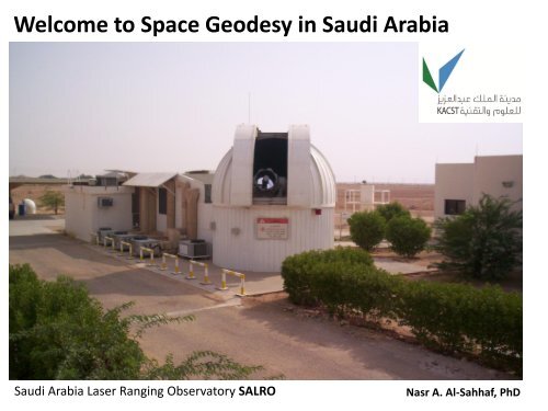
Welcome to Space Geodesy in Saudi Arabia
Welcome to Space Geodesy in Saudi Arabia
Welcome to Space Geodesy in Saudi Arabia

You also want an ePaper? Increase the reach of your titles
YUMPU automatically turns print PDFs into web optimized ePapers that Google loves.
<strong>Welcome</strong> <strong>to</strong> <strong>Space</strong> <strong>Geodesy</strong> <strong>in</strong> <strong>Saudi</strong> <strong>Arabia</strong><br />
<strong>Saudi</strong> <strong>Arabia</strong> Laser Rang<strong>in</strong>g Observa<strong>to</strong>ry SALRO<br />
Nasr A. Al-Sahhaf, PhD
<strong>Saudi</strong> <strong>Arabia</strong>n <strong>Space</strong> <strong>Geodesy</strong> Program Plan<br />
For<br />
SALRO <strong>to</strong> became a Global Geodetic Core Station<br />
By means of<br />
Co-locat<strong>in</strong>g multiple geodetic <strong>in</strong>struments, each<br />
provid<strong>in</strong>g for a different measur<strong>in</strong>g technique<br />
allow<strong>in</strong>g for data <strong>to</strong> be correlated thus provid<strong>in</strong>g<br />
improved accuracy and <strong>in</strong>tegrity
<strong>Saudi</strong> <strong>Arabia</strong>n <strong>Space</strong> <strong>Geodesy</strong> Program<br />
Geodetic Instruments for National and Global<br />
Reference Frames, Geodetic Research, Earth<br />
Science Studies and <strong>Space</strong> Exploration<br />
Lunar Laser Rang<strong>in</strong>g – LLR<br />
Satellite Laser Rang<strong>in</strong>g – SLR<br />
<strong>Space</strong> Debris Track<strong>in</strong>g – SDT<br />
Global Position<strong>in</strong>g System – GPS<br />
Very Long Basel<strong>in</strong>e Interferometry – VLBI<br />
Cont<strong>in</strong>uous Operat<strong>in</strong>g GNSS Network– COGNET<br />
Program Active<br />
Future Plans
<strong>Saudi</strong> <strong>Arabia</strong>n <strong>Space</strong> <strong>Geodesy</strong> Program<br />
Lunar Laser Rang<strong>in</strong>g – LLR<br />
* Function<br />
The LLR is a geodetic <strong>in</strong>strument capable of measur<strong>in</strong>g the distance between our Planet<br />
Earth and the Moon with a high degree of accuracy<br />
* Operation<br />
High energy laser pulses are transmitted <strong>to</strong> the Lunar surface and reflected back <strong>to</strong> the LLR-<br />
Observa<strong>to</strong>ry (Earth Station) from the retroreflec<strong>to</strong>r placed on the Moon dur<strong>in</strong>g the Apollo<br />
<strong>Space</strong> Missions <strong>to</strong> measure the Time of Flight (TOF)<br />
* Measurement<br />
The LLR measures the Time Of Flight (TOF) of very short laser pulses travel<strong>in</strong>g from the<br />
station <strong>to</strong> the Moon and back.<br />
Application<br />
LUNAR science, geodynamics, gravitational physics , astronomy and many more
Lunar Laser Rang<strong>in</strong>g – LLR<br />
Laser Rang<strong>in</strong>g Retro-Reflec<strong>to</strong>r<br />
NASA pho<strong>to</strong> of Apollo Mission<br />
TOF<br />
Picture of an LLR Observa<strong>to</strong>ry <strong>in</strong> New Mexico<br />
rang<strong>in</strong>g <strong>to</strong> the Moon<br />
The distance between the Earth and the Moon<br />
is calculated with a high degree of accuracy<br />
from the TOF Equation: d = c x t / 2<br />
d distance, c formula for speed of light and t<br />
round-trip of time of flight
Plot: LLR return signals<br />
Credit: The Apollo Lunar Rang<strong>in</strong>g Collaboration
<strong>Saudi</strong> <strong>Arabia</strong>n <strong>Space</strong> <strong>Geodesy</strong> Program<br />
Satellite Laser Rang<strong>in</strong>g – SLR<br />
* Function<br />
The SLR System is an <strong>in</strong>strument that forms part of a global network of stations measur<strong>in</strong>g<br />
the orbital paths of geodetic satellites<br />
* Operation<br />
SLR transmits short laser pulses <strong>to</strong> geodetic satellites orbit<strong>in</strong>g the Earth as they pass through<br />
the SLR Station field of view, these pulses are then reflected back from the satellites <strong>to</strong> the<br />
SLR System for Time Of Flight (TOF) measurements<br />
* Measurement<br />
TOF measurements are used <strong>to</strong> compute <strong>in</strong>stantaneous range measurements <strong>to</strong> satellites<br />
with sub centimeter accuracy<br />
* Application<br />
Planetary Geodynamics support<strong>in</strong>g the International terrestrial reference frame (ITRF),<br />
scientific studies of the Earth its atmosphere and the oceans
SALRO rang<strong>in</strong>g <strong>to</strong> satellite <strong>in</strong> orbit<br />
What appears <strong>to</strong> be a<br />
cont<strong>in</strong>ues laser beam is<br />
actually a tra<strong>in</strong> of very<br />
short pulses of less that<br />
200 pico seconds<br />
The exact time of each<br />
pulse leav<strong>in</strong>g the<br />
station and return<strong>in</strong>g<br />
back is measured <strong>to</strong><br />
determ<strong>in</strong>e the time of<br />
flight that is used <strong>to</strong><br />
determ<strong>in</strong>e the distance<br />
between the station<br />
and the satellite
Global Network of SLR Stations<br />
SALRO
<strong>Saudi</strong> <strong>Arabia</strong>n <strong>Space</strong> <strong>Geodesy</strong> Program<br />
<strong>Space</strong> Debris Track<strong>in</strong>g – SDT<br />
* Function<br />
The <strong>Space</strong> Debris Track<strong>in</strong>g System is an <strong>in</strong>strument able <strong>to</strong> detect, identify and track space<br />
debris objects orbit<strong>in</strong>g our Planet<br />
* Operation<br />
Different techniques are used for debris track<strong>in</strong>g: Like <strong>Space</strong> Optical Image Track<strong>in</strong>g, RADAR<br />
Track<strong>in</strong>g and LASER Track<strong>in</strong>g. <strong>Saudi</strong> <strong>Arabia</strong> is plann<strong>in</strong>g <strong>to</strong> make use of a Multimode LASER<br />
Track<strong>in</strong>g System<br />
* Measurement<br />
Different measur<strong>in</strong>g techniques are used, with a multimode laser track<strong>in</strong>g system <strong>in</strong>stalled<br />
(SDT, LLR and SLR) <strong>Saudi</strong> will benefit from significantly enhanced data quality and <strong>in</strong>tegrity by<br />
correlat<strong>in</strong>g data obta<strong>in</strong>ed from the multiple techniques referenced <strong>to</strong> the same reference<br />
position (Monument)<br />
* Application<br />
To identify and track space debris (natural and man made) and <strong>to</strong> catalogue them <strong>in</strong> support<br />
of current and future space programs , space exploration and efforts <strong>to</strong> remove the debris
Satellites and Debris orbit<strong>in</strong>g the Earth<br />
View from outside geosynchronous orbit<br />
Natural Debris:<br />
Small pieces of<br />
meteorites, com<strong>in</strong>g from<br />
our solar system and<br />
orig<strong>in</strong>ate from asteroids<br />
and plane<strong>to</strong>ids orbit<strong>in</strong>g<br />
the Earth<br />
Artificial Debris:<br />
Man-made objects like<br />
rema<strong>in</strong>s of spacecrafts,<br />
their payloads and<br />
hardware <strong>in</strong>clud<strong>in</strong>g<br />
fragments from<br />
collisions
<strong>Saudi</strong> <strong>Arabia</strong>n <strong>Space</strong> <strong>Geodesy</strong> Program<br />
Global Position<strong>in</strong>g System – GPS<br />
* Function<br />
A constellation of satellites that provides for radio signals <strong>to</strong> GPS receivers enabl<strong>in</strong>g them <strong>to</strong><br />
calculate their positions<br />
* Operation<br />
GPS signals are received by the receivers, they processed these signals <strong>to</strong> determ<strong>in</strong>e their<br />
location <strong>in</strong> three dimensions<br />
* Measurement<br />
GPS satellites are equipped with high accurate tim<strong>in</strong>g systems synchronized <strong>to</strong> facilitate<br />
simultaneous transmission of position <strong>in</strong>formation. This <strong>in</strong>formation arrive at the at the GPS<br />
receiver at slightly different times. The receiver then measures and compute the phase<br />
relationship of these signals <strong>to</strong> determ<strong>in</strong>e its position with a high degree of accuracy<br />
*Application<br />
Navigation, Global terrestrial reference frame, mapp<strong>in</strong>g, moni<strong>to</strong>r<strong>in</strong>g of geodetic reference<br />
monuments, track<strong>in</strong>g and guid<strong>in</strong>g of mov<strong>in</strong>g objects and many other geodetic applications
Geodetic Instruments co-located at SALRO<br />
SLR<br />
GPS<br />
Co-locat<strong>in</strong>g of<br />
space geodesy<br />
<strong>in</strong>struments adds<br />
value <strong>to</strong> the<br />
<strong>in</strong>tegrity of the<br />
data produced
SALRO-IGN “Tie-<strong>in</strong>” (Survey<strong>in</strong>g Mission 2012)<br />
Monuments,<br />
benchmarks and<br />
calibration piers have<br />
been surveyed with a<br />
high degree of precision<br />
as part of the “tie-<strong>in</strong>”<br />
solution for the SALRO<br />
co-located SLR and GPS<br />
(SOLA) <strong>in</strong>struments
<strong>Saudi</strong> <strong>Arabia</strong>n <strong>Space</strong> <strong>Geodesy</strong> Program<br />
Very Long Basel<strong>in</strong>e Interferometry – VLBI<br />
* Function<br />
The VLBI System is a radio telescope (Astronomical Interferometry Instrument) that allows for<br />
image observation of distant cosmic radio sources<br />
* Operation<br />
When the VLBI data is correlated with data collected from other Radio Telescopes<br />
simultaneously recorded they produce an image size of equal <strong>to</strong> the maximum separation<br />
between the telescopes serv<strong>in</strong>g as one giant telescope<br />
* Measurement<br />
VLBI Systems have very accurate tim<strong>in</strong>g systems typically hydrogen maser clocks <strong>to</strong> facilitate<br />
accurate measurements of the time differences between the arrival of cosmic radio sources<br />
(phase angle of the radio waves) at the separate observa<strong>to</strong>ries<br />
* Application<br />
Radio Astronomy, track<strong>in</strong>g of spacecrafts and many space geodesy science applications
VLBI observ<strong>in</strong>g a po<strong>in</strong>t source (Extra Terrestrial Radio Signal)<br />
Extra terrestrial<br />
radio emissions<br />
comes from a<br />
variety of sources<br />
like the Sun, the<br />
Galactic center,<br />
Supernova,<br />
Pulsars, Quasars<br />
and many more<br />
objects <strong>in</strong> outer<br />
space
<strong>Saudi</strong> <strong>Arabia</strong>n <strong>Space</strong> <strong>Geodesy</strong> Program<br />
Cont<strong>in</strong>uous Operat<strong>in</strong>g GNSS Network– COGNET<br />
* Function<br />
COGNET is a network of GPS receivers that measures the differential position<strong>in</strong>g of<br />
various fixed terrestrial reference po<strong>in</strong>ts<br />
* Operation<br />
Satellite navigation systems provide au<strong>to</strong>nomous geo-spatial position<strong>in</strong>g signals<br />
with global coverage, these signals when received by the GPS receiver are<br />
processed <strong>to</strong> produce position<strong>in</strong>g data<br />
* Measurement<br />
Carrier phase measurements are used <strong>in</strong> addition <strong>to</strong> pseudo ranges due <strong>to</strong> their<br />
superior accuracy <strong>to</strong> provide for accurate position<strong>in</strong>g data<br />
* Application<br />
To def<strong>in</strong>e the International terrestrial reference frame, for land, ocean and airspace<br />
navigation, steer<strong>in</strong>g and controll<strong>in</strong>g of mach<strong>in</strong>e and man-made mov<strong>in</strong>g objects,<br />
mapp<strong>in</strong>g and many other applications
COGNET - Overview<br />
KSA-COGNET will<br />
serve as the<br />
backbone GNSS<br />
Network <strong>in</strong> the<br />
K<strong>in</strong>gdom provid<strong>in</strong>g a<br />
platform for high<br />
precision geodesy<br />
and Earth science<br />
applications.<br />
It will be compatible<br />
and <strong>in</strong> agreement<br />
with the International<br />
Terrestrial Reference<br />
Frame (ITRF)<br />
standards thus<br />
becom<strong>in</strong>g part of the<br />
Global Network of<br />
GNSS Stations
KSA-COGNET Scout<strong>in</strong>g Mission<br />
The mission after<br />
theoretical<br />
calculations was <strong>to</strong><br />
identify 16 sites for<br />
the COGNET<br />
<strong>in</strong>frastructure, <strong>in</strong><br />
order <strong>to</strong> meet with<br />
the m<strong>in</strong>imum<br />
density for a<br />
National CORS<br />
network.<br />
In addition <strong>to</strong> this<br />
we have selected 2<br />
more sites <strong>to</strong> avoid<br />
any possible site<br />
related problems
KSA-COGNET Scout<strong>in</strong>g Mission<br />
Amana - Site<br />
Hail - Site<br />
Tayma - Site<br />
Jizan - Site<br />
Saqaqa - Site<br />
Sharurah - Site<br />
Many fac<strong>to</strong>rs were taken <strong>in</strong><strong>to</strong><br />
consideration for select<strong>in</strong>g the<br />
best sites for the network, below<br />
is a brief list of some of the<br />
criteria taken <strong>in</strong><strong>to</strong> account dur<strong>in</strong>g<br />
the scout<strong>in</strong>g mission<br />
* Durability<br />
* Long term satellite visibility<br />
* Monument stability<br />
* Availability of power<br />
* Internet connectivity<br />
* Non-<strong>in</strong>terference signals<br />
* Low risk of future obstructions<br />
*Installation costs<br />
* Accessibility<br />
* Security
Monument Specification for site <strong>in</strong>stallation
<strong>Saudi</strong> <strong>Arabia</strong>n <strong>Space</strong> <strong>Geodesy</strong> Program<br />
Data Process<strong>in</strong>g with MicroCosm Software<br />
Instrument Error Correction<br />
Models<br />
Geodetic Instruments<br />
Instrument Clock and Tim<strong>in</strong>g<br />
Instrument Biases<br />
Monument Shift<br />
Measurement Ambiguities<br />
Calibration<br />
Noise<br />
Jitter<br />
Earth Rotation<br />
Earth Gravitation<br />
Tropospheric Refraction<br />
Earth Precession<br />
Solar Radiation Pressure<br />
Atmospheric Drag<br />
Tec<strong>to</strong>nic Plate Motion<br />
Polar Motion<br />
Solid Earth Tides<br />
Ocean Tides<br />
Ocean Load<strong>in</strong>g<br />
SLR<br />
LLR<br />
GNSS<br />
TDRS<br />
DORIS<br />
Radar Alt.
Microcosm geodetic parameter determ<strong>in</strong>ation<br />
Some of the key capabilities:<br />
Numeric <strong>in</strong>tegration of satellite parameters of motion for orbit prediction<br />
State vec<strong>to</strong>r estimation<br />
Atmospheric drag<br />
Solar radiation<br />
Time tag biases and station clock polynomials<br />
Tropospheric refraction<br />
Lunar, solar and planetary gravitational efficiencies<br />
Station coord<strong>in</strong>ates<br />
Polar motion and Earth rotation<br />
Solid Earth and ocean tides<br />
Tec<strong>to</strong>nic plate movement<br />
Simultaneous process<strong>in</strong>g of multiple satellites per data arc
<strong>Saudi</strong> <strong>Arabia</strong> and its adjacent tec<strong>to</strong>nic plates<br />
Map: Illustrat<strong>in</strong>g the<br />
relationship between<br />
the <strong>Arabia</strong>n and<br />
adjacent African,<br />
Indian and Eurasian<br />
tec<strong>to</strong>nic plates<br />
Geodetic data needs<br />
<strong>to</strong> be processed <strong>to</strong><br />
support scientific<br />
studies t<strong>in</strong> order o<br />
fully understand the<br />
tec<strong>to</strong>nic plate<br />
activities and predict<br />
the <strong>in</strong>fluence it will<br />
have on man k<strong>in</strong>d
Patents<br />
SALRO (SLR System)<br />
Patents pend<strong>in</strong>g<br />
Mechanical Design<br />
Electronic Design<br />
Optic and Laser Design<br />
* Precision optical mounts<br />
* High voltage enclosures<br />
* Special-<strong>to</strong>-type fixtures<br />
* High voltage power supplies<br />
* Control and logic circuits<br />
* Fast pho<strong>to</strong>n detection circuits<br />
* Q-switch control circuitry<br />
* Avalanche switch<strong>in</strong>g devices<br />
* Laser optical sub-systems<br />
* Laser System
Mechanical Design<br />
Pictures of some of<br />
the precision<br />
mechanical mounts<br />
locally developed and<br />
manufactured. This<br />
was <strong>to</strong> meet with<br />
laser specific<br />
requirements
Electronic Design<br />
Pictures of some of<br />
the electronic<br />
equipment locally<br />
developed<br />
Top left is 2 high<br />
voltage power<br />
supplies, <strong>in</strong> the<br />
middle is the new<br />
laser safety security<br />
system and at the<br />
bot<strong>to</strong>m the new<br />
laser receive<br />
controller
Laser and Optical Design<br />
Laser and optical<br />
development<br />
<strong>in</strong>cludes pho<strong>to</strong><br />
detection, modelock<strong>in</strong>g,<br />
q-switch<strong>in</strong>g<br />
and optical subsystems<br />
.<br />
Regret no pictures
Thank you<br />
Nasr A. Al-Sahhaf, PhD<br />
Direc<strong>to</strong>r, <strong>Saudi</strong> <strong>Space</strong> <strong>Geodesy</strong> Center<br />
K<strong>in</strong>g Abdulaziz City for Science and Technology