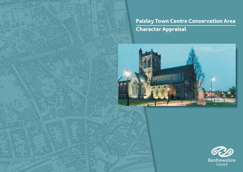
Paisley Town Centre Conservation Area Character Appraisal
Paisley Town Centre Conservation Area Character Appraisal
Paisley Town Centre Conservation Area Character Appraisal

Create successful ePaper yourself
Turn your PDF publications into a flip-book with our unique Google optimized e-Paper software.
<strong>Paisley</strong> <strong>Town</strong> <strong>Centre</strong> <strong>Conservation</strong> <strong>Area</strong><br />
<strong>Character</strong> <strong>Appraisal</strong><br />
<strong>Paisley</strong> <strong>Town</strong> <strong>Centre</strong> <strong>Conservation</strong> <strong>Area</strong> 1 <strong>Character</strong> <strong>Appraisal</strong>
<strong>Paisley</strong> <strong>Town</strong> <strong>Centre</strong> <strong>Conservation</strong> <strong>Area</strong> 2 <strong>Character</strong> <strong>Appraisal</strong><br />
Mapping on cover © Crown Copyright and Landmark Information Group Ltd. All rights reserved 2008
SUMMARY<br />
<strong>Paisley</strong> <strong>Town</strong> <strong>Centre</strong> <strong>Conservation</strong> <strong>Area</strong> has a complex<br />
structure and mixed character as the result of eight<br />
and a half centuries of development. It has three main<br />
parts:<br />
1) The peaceful, green, riverside areas presided over by<br />
the <strong>Town</strong> Hall and Abbey;<br />
2) The busy shopping streets stretching in all directions<br />
from the Cross that are enclosed with terraces of<br />
individually designed tenements and irregular runs of<br />
Georgian buildings;<br />
3) Oakshaw Hill, a quiet area that sits above the town<br />
with a memorable, romantic skyline of towers, domes<br />
and spires rising above slated roofs and trees.<br />
The original ecclesiastical village’s few irregular streets<br />
were added to piecemeal in the 18 th century as it grew<br />
rapidly from a small market town to Scotland’s premier<br />
centre of handloom weaving.<br />
Though mostly widened in the late 19 th century, the<br />
streets retain the informal layout of the earlier town.<br />
Within it are concentrated many public buildings of a<br />
scale and quality found usually only in cities, providing<br />
an outstanding townscape.<br />
While buildings survive from most periods of the<br />
town’s long history, architecturally it is the handsome<br />
late Victorian public buildings and four storey<br />
tenements which do most to establish the town<br />
centre’s character. Contrasting with them there are<br />
many more modest Georgian buildings.<br />
Segments of the historic town were lost with<br />
redevelopment in the 1960s-70s but overall the town<br />
centre has been well conserved, adapted to change and<br />
enhanced, especially Oakshaw with many new homes<br />
provided in converted and new buildings.<br />
Thirty years since the designation of the original Cross<br />
and Oakshaw <strong>Conservation</strong> <strong>Area</strong>, existing boundaries<br />
have been reviewed. It is proposed to extend the<br />
southern boundary to include Causeyside Street with<br />
its fine tenements up to Canal Street Station and the<br />
listed church and former fire station in Gordon Street.<br />
Problems and threats across the <strong>Conservation</strong> <strong>Area</strong><br />
include the accelerating loss of retail custom to<br />
competing shopping centres. This affects the condition<br />
of all the shopping streets resulting in a growing<br />
number of vacant and poorly maintained retail units.<br />
This is compounded by a reduction in the use of<br />
property on upper floors.<br />
Extending the conservation area will give more<br />
powers to control detrimental changes and make<br />
funds available to ensure that repair of buildings,<br />
redevelopment of gap sites and upgrading of street<br />
surfaces are delivered to a standard that will enhance<br />
the overall quality of the town centre.<br />
Renfrewshire Council Department of Planning and Transport, 2008.<br />
<strong>Paisley</strong> <strong>Town</strong> <strong>Centre</strong> <strong>Conservation</strong> <strong>Area</strong> 1 <strong>Character</strong> <strong>Appraisal</strong>
Contents<br />
1. Introduction 1<br />
2. Historical Development 1<br />
2.1 Summary 1<br />
2.2 From Abbey with dependent village to small market town, 1163 – 1560. 1<br />
2.3 Rapid expansion to major textile town, post 1707 - 1820s. 1<br />
2.4 Late Victorian rebuilding, 1860s – 1914. 8<br />
2.5 Inter and post war redevelopment, 1918 -1970s. 9<br />
2.6 <strong>Conservation</strong> and adaptation, 1970s - present. 10<br />
3. <strong>Character</strong> areas 11<br />
3.1 <strong>Town</strong> Hall and Abbey 11<br />
3.2 Oakshaw 13<br />
3.3 The Cross and the High Street 13<br />
3.4 Moss Street - County Place 15<br />
3.5 Causeyside Street - Gordon Street 15<br />
3.6 New Street - George Street 16<br />
4. The Boundaries of the <strong>Conservation</strong> <strong>Area</strong> 17<br />
5. Issues 18<br />
5.1 Building Repair and Reuse 18<br />
5.2 Gap Sites 19<br />
5.3 Public <strong>Area</strong>s 19<br />
5.4 Summary of Issues 20<br />
6. Conclusion 20<br />
7. Appendices 21<br />
App 1 Definition of a conservation area 21<br />
App 2 Local Plan Policies for the Built Heritage 21<br />
App 3 Principal buildings of the six character areas 23<br />
App 4 Listed buildings in the proposed extension area 25<br />
<strong>Paisley</strong> <strong>Paisley</strong> <strong>Town</strong> <strong>Town</strong> <strong>Centre</strong> <strong>Centre</strong> <strong>Conservation</strong> <strong>Conservation</strong> <strong>Area</strong> <strong>Area</strong><br />
3 <strong>Character</strong> <strong>Character</strong> <strong>Appraisal</strong> <strong>Appraisal</strong>
PLAN 1 - <strong>Paisley</strong> <strong>Town</strong> <strong>Centre</strong><br />
<strong>Conservation</strong> <strong>Area</strong><br />
The Cross and Oakshaw (1975)<br />
The Cross/Oakshaw (1980)<br />
Proposed Extension<br />
Listed Buildings<br />
This map is reproduced from Ordnance Survey material with the permission of Ordnance Survey on behalf of the<br />
Controller of Her Majesty's Stationery Office © Crown Copyright. Unauthorised reproduction infringes Crown<br />
copyright and may lead to prosecution or civil proceedings. Renfrewshire Council 100023417 2008<br />
Renfrewshire Council<br />
Printed by: K Ferguson<br />
-<br />
Print date: 2/9/08 0 30 60 120 180<br />
Department: Planning and Transport<br />
Meters<br />
<strong>Paisley</strong> <strong>Town</strong> <strong>Centre</strong> <strong>Conservation</strong> <strong>Area</strong> 4 <strong>Character</strong> <strong>Appraisal</strong>
1. Introduction<br />
This document gives an appraisal of the character of<br />
the existing Cross/Oakshaw Outstanding <strong>Conservation</strong><br />
<strong>Area</strong>, <strong>Paisley</strong> and an area to its south proposed as an<br />
extension (see Plan 1).<br />
The purpose of a <strong>Conservation</strong> <strong>Area</strong> <strong>Appraisal</strong> is to<br />
define what are its important features, and its salient<br />
and significant characteristics (see Appendix 1).<br />
This is the starting point for deciding what should<br />
be protected and enhanced by planning authorities,<br />
residents and property owners, and what problems<br />
need to be addressed.<br />
It covers the area’s historic development, its special<br />
historic, townscape and architectural interest, and<br />
includes consideration of significant buildings and open<br />
spaces which establish the character of the area.<br />
This then informs consideration of what should be the<br />
conservation area’s boundaries. It provides a context<br />
for the assessment of development proposals within<br />
the area, identifies opportunities and priorities for<br />
enhancement, and sets out the policy framework for<br />
the determination of development proposals. This<br />
appraisal is supplementary to the policies for the built<br />
heritage set out in the Renfrewshire Local Plan (see<br />
Appendix 2).<br />
2. Historical Development<br />
2.1 Summary<br />
As a result of its topography and a long and disjointed<br />
history, <strong>Paisley</strong> town centre has great complexity and<br />
variety concentrated in a relatively small area. Even<br />
individual streets rarely have one consistent character.<br />
This brief history of the town is provided to assist the<br />
understanding of why and how the town came to have<br />
its present form and character, and to help to make an<br />
assessment of the elements which make it today.<br />
<strong>Paisley</strong>’s history can be outlined as having four distinct<br />
periods of development separated by three periods<br />
of stagnation. The discontinuities in this history have<br />
created a town centre which is irregular in layout, has<br />
areas of varying character, and buildings which often<br />
contrast with their neighbours in scale and character.<br />
2.2 From Abbey and dependent village to small<br />
market town<br />
<strong>Paisley</strong> is sited on the White Cart River at its highest<br />
navigable point from the Clyde and the lowest point<br />
where it could be forded, on the important route<br />
between the South West and central belt of Scotland.<br />
St Mirin is said to have built a chapel on the east bank<br />
in the 6 th century, and monks granted lands here in<br />
1163 built the abbey on its reputed site. Their monastic<br />
precinct occupied most of the level east bank, so the<br />
dependent village grew up on the more undulating<br />
west bank, along the irregular tracks leading down<br />
to the ford opposite the abbey. This established the<br />
distinct character of the east and west sides of the<br />
town.<br />
The village was made a burgh in 1488, gaining the right<br />
to hold a market, which was held at the Cross. The<br />
construction of the first bridge over the Cart (St James)<br />
about 1490 helped make it the principal market centre<br />
of Renfrewshire. But the closure of the monastery in<br />
the Reformation (1560) ended this stage of <strong>Paisley</strong>’s<br />
development (see Plan 2 and Plate 1).<br />
Plan 2: Timothy Pont’s plan of <strong>Paisley</strong>, 1580s-90s, showing<br />
the High St to left and the Abbey precinct walls to the right.<br />
2.3 Rapid expansion to major textile town<br />
The opening up of trade with the Empire following<br />
the Act of Union in 1707 saw a rapid expansion<br />
of manufacturing, especially of textiles. <strong>Paisley</strong>’s<br />
population grew faster than anywhere else in Scotland,<br />
until by 1820 it was the third largest settlement in<br />
the nation. Development extended out along the old<br />
routes into the village - the High Street, Moss Street<br />
<strong>Paisley</strong> <strong>Town</strong> <strong>Centre</strong> <strong>Conservation</strong> <strong>Area</strong> 5 <strong>Character</strong> <strong>Appraisal</strong>
Plan 3: William Roy’s military map, 1754, showing New<br />
St and Orchard St added.<br />
Plate 1: View from Saucel Hill by John Slezer, 1693.<br />
Old Tollbooth Bridge<br />
Abbey River<br />
and Causeyside Street. Starting with New Street in<br />
1724, new streets were laid out incrementally without<br />
any overall plan, adding to the irregularity of the street<br />
pattern (see Plans 3 and 4).<br />
The old thatched cottages at the heads of the long<br />
medieval burgage plots were redeveloped one by one<br />
with two to four storey buildings and the back courts<br />
built up. Most of these new Georgian buildings were<br />
modest, built with local buff sandstone and roofed<br />
with slates. The only surviving landmark public building<br />
of this period is the High Church (Oakshaw Trinity) on the<br />
east end of the long Oakshaw hill above the town centre.<br />
The only new public open space created was County<br />
Square, laid out in front of the County Buildings (1820,<br />
demolished c 1971). The construction of the Glasgow<br />
to Johnstone canal in 1810 and the railway in 1840<br />
defined the centre from its southern and northern<br />
satellites (see Plate 2).<br />
Plan 4: William Semple’s map, 1787, showing many<br />
additional streets laid out since Roy’s map and<br />
development extending along them.<br />
<strong>Paisley</strong> <strong>Town</strong> <strong>Centre</strong> <strong>Conservation</strong> <strong>Area</strong> 6 <strong>Character</strong> <strong>Appraisal</strong>
High Church Tollbooth Jail &<br />
Bridge<br />
Plate 2: View from Saucel Hill by Clark, 1825, with canal to right and High Church to left.<br />
Abbey<br />
Canal<br />
<strong>Paisley</strong> <strong>Town</strong> <strong>Centre</strong> <strong>Conservation</strong> <strong>Area</strong> 7 <strong>Character</strong> <strong>Appraisal</strong>
2.4 Late Victorian rebuilding<br />
After 40 years of severe depression, growth resumed<br />
in the1860s. The economy came to be dominated by<br />
larger scale manufacturing, notably in the thread works<br />
of the Coats and Clark families to the west and east of<br />
the centre. To cope with increasing road traffic in what<br />
was now the hub of a large town, and to provide better<br />
commercial and residential accommodation, most<br />
of the streets of the town centre were widened from<br />
1862.<br />
This was done mostly by rebuilding properties on only<br />
one side of the thoroughfare, creating unbalanced<br />
streets, and making the irregularity and mixed quality<br />
of the retained Georgian facades more apparent. (see<br />
plate 11). The traffic bottleneck of the medieval St<br />
Mirren Street was overcome in 1875 with the new<br />
street we know today, creating the site for Dunn<br />
Square, laid out in 1894 (see Plan 5).<br />
Causeyside Street was widened along its entire length,<br />
creating a handsome approach to the town centre<br />
from the Canal Street station (1885). Almost all of the<br />
four storey tenements were developed by separate<br />
owners to individual designs of local architects, giving<br />
an interesting variety to the street scene. The most<br />
prominent features of these tenements are their<br />
corners, which were often given special treatment such<br />
as round or facetted towers.<br />
The character of the town was most dramatically<br />
changed by the erection of several large public<br />
buildings in contrasting architectural styles, notably<br />
the John Neilson Institution (1852), (see plate 21) the<br />
classical Museum (1868-) (see plate 19), the Italianate<br />
Plan 5: 2 nd edition OS, 1893<br />
<strong>Paisley</strong> <strong>Town</strong> <strong>Centre</strong> <strong>Conservation</strong> <strong>Area</strong> 8 <strong>Character</strong> <strong>Appraisal</strong>
Clark <strong>Town</strong> Hall (1882) and the Gothic Coats Memorial<br />
Church (1884).<br />
Churches proliferated, with Oakshaw Hill a favoured<br />
location, and the north transept, choir and massive<br />
tower were added to the Abbey nave in four stages<br />
(between 1862 and 1928).<br />
While County Square had been formed to give an<br />
appropriately grand setting for County Buildings, most<br />
of these later great buildings were slotted into the<br />
existing fabric with little change to their surroundings.<br />
Though widened, the old streets retained the informal<br />
character of the 18 th century town. However, the great<br />
public buildings and their concentration within a small<br />
area gave the centre the character of a city more than<br />
any other Scottish town.<br />
The Abbey precinct had been developed in the 18 th<br />
century as ‘<strong>Paisley</strong> New <strong>Town</strong>’, but having become run<br />
down the area around the Abbey and <strong>Town</strong> Hall was<br />
cleared (1873-1920s) to give them an open setting.<br />
This partly restored the contrasting characters of the<br />
town on the two banks of the river.<br />
2.5 Interwar and post war developments<br />
After the interruption of the First World War, some<br />
of the pre-war changes were continued, notably the<br />
completion of the Abbey, the clearance of the buildings<br />
around it, and the widening of streets from the Cross<br />
down to the <strong>Town</strong> Hall and Forbes Place.<br />
Tenement construction was not resumed and no<br />
further city scale buildings were commissioned.<br />
Plate 3: View from Saucel Hill c 1890, with the <strong>Town</strong> Hall in the centre and abbey nave to its right.<br />
However, the architectural sophistication of several<br />
replaced large areas of the inherited urban fabric.<br />
new buildings erected shows a continuing pride and<br />
<strong>Paisley</strong> University (1963) opened a wide gap in the<br />
originality, most notably the Cenotaph (1922) and the<br />
west end High Street frontage, and added a bulky six<br />
Russell Institute (1926) (see plate 22).<br />
storey tower into views of the Oakshaw skyline from<br />
the south.<br />
As old industries closed down, the high chimneys were<br />
removed from the skyline. <strong>Town</strong> centre slum residents<br />
The ambitious Civic <strong>Centre</strong> (1966-71) in Cotton Street<br />
were rehoused on suburban council housing estates.<br />
replaced yet more of the New <strong>Town</strong>. Softened by<br />
Manufacturing decline set in seriously in the 1950s, and landscaping, it served as a neutral though over scaled<br />
service industries became dominant.<br />
backdrop to the Abbey. The Piazza (1968-70) shopping<br />
mall with three long office slab blocks and a multistorey<br />
car park rising to five storeys was built over the<br />
The town centre was adapted to this with three<br />
major comprehensive redevelopment schemes which<br />
river from St James Bridge to the railway viaduct.<br />
<strong>Paisley</strong> <strong>Town</strong> <strong>Centre</strong> <strong>Conservation</strong> <strong>Area</strong> 9 <strong>Character</strong> <strong>Appraisal</strong>
2.6 <strong>Conservation</strong> and adaptation, 1970s - present<br />
The damage which the comprehensive redevelopment<br />
approach was doing to the historic towns and cities<br />
of Britain was recognised in the 1960s, as was the<br />
contribution which conserving historic buildings and<br />
areas can make to economic regeneration. Starting in<br />
1971, buildings of architectural interest were protected<br />
from demolition and unsympathetic alteration.<br />
The Cross and Oakshaw were designated as<br />
conservation areas in 1975 and amalgamated and<br />
extended in 1980, an area which today has 101 listed<br />
buildings of which 14 are Category A. The three major<br />
1960s redevelopment schemes were excluded from the<br />
conservation area.<br />
Oakshaw, where the John Neilson Institution stood<br />
derelict from 1971 was picked out for major public<br />
investment in 1985, a process which resulted in a<br />
tripling of the number of dwellings on the hill, most of<br />
them in redundant listed buildings.<br />
A new approach to redevelopment was set by the<br />
<strong>Paisley</strong> Urban Design Framework adopted by the<br />
Council in 1990. The <strong>Paisley</strong> (shopping) <strong>Centre</strong><br />
development (1992) followed these by being carefully<br />
fitted into the High Street-Causeyside Street-New<br />
Street block behind retained historic facades and new<br />
‘contextual’ ones. While giving additional modern<br />
shopping accommodation, the two indoor shopping<br />
centres made the old main street shops less viable, and<br />
increased the problem faced today of retail business<br />
loss.<br />
JNI Coats Church Observatory Orr Sq. Church High Church Wynd <strong>Centre</strong><br />
<strong>Town</strong> Hall<br />
Abbey<br />
Plate 4 Panorama from Saucel Hill, 2008<br />
<strong>Paisley</strong> <strong>Town</strong> <strong>Centre</strong> <strong>Conservation</strong> <strong>Area</strong> 10 <strong>Character</strong> <strong>Appraisal</strong>
3. <strong>Character</strong> areas (see Plan 6)<br />
The <strong>Conservation</strong> <strong>Area</strong> has three main contrasting<br />
areas: the <strong>Town</strong> Hall-Abbey-riverside area, Oakshaw<br />
hill, and the urban shopping streets. This last area can<br />
be divided into four parts, making six areas in which<br />
certain characteristics or features predominate. Each<br />
has several important and memorable buildings (see<br />
Appendix 3).<br />
3.1 The <strong>Town</strong> Hall - Abbey <strong>Area</strong><br />
This area’s predominant features are its two<br />
contrasting monumental buildings and the green<br />
spaces and the river across which they are viewed.<br />
While the<strong>Town</strong> Hall relates to the busy Cross and<br />
High Street, this area is otherwise a quiet backwater,<br />
protected from the impact of ring road traffic to the<br />
east by the high walls of the Cotton Street buildings.<br />
building is too distant to define this space well. The<br />
<strong>Town</strong> Hall’s imposing entrance front commands the<br />
view down Gauze Street from as far off as the end of<br />
Glasgow Road.<br />
The contrasting west front of the <strong>Town</strong> Hall rises sheer<br />
from the river’s edge; its twin towers providing dramatic<br />
vertical features which dominate views downstream<br />
from the Abbey Bridge and Forbes Place (see Plate 5).<br />
The <strong>Town</strong> Hall screens the Abbey from the bustle of<br />
the Cross, and it is only from the end of Causeyside<br />
Street that its west front can be seen as it was designed<br />
to impress approaching medieval pilgrims fording the<br />
river.<br />
The Abbey with the Place of <strong>Paisley</strong> are a pervading<br />
presence from Forbes Place, Riverside Walk and Abbey<br />
Bridge, where not excessively screened by trees. The<br />
definition of the wider space to the south west of the<br />
Abbey, and the special character of the riverside walk<br />
are weakened somewhat by the gap site in Forbes Place<br />
and the single storey former industrial building on<br />
Bridge Street.<br />
The Abbey and the <strong>Town</strong> Hall relate obliquely to each<br />
with their sides defining the spaces facing each other’s<br />
fronts. The green area which the town hall overlooks<br />
historically belongs to the Abbey, being the town’s<br />
oldest graveyard. However, its character has been lost<br />
by laying flat the gravestones and allowing them to<br />
become covered by turf, and by removal of surrounding<br />
walls and railings. The presence of the graves, lack of<br />
paths and the shade cast by the Abbey inhibits its use<br />
for relaxation, closer viewing of the Abbey, and taking<br />
short cuts along its north side.<br />
To the south the space in front of the <strong>Town</strong> Hall is well<br />
defined by the Central Methodist Halls and the former<br />
Arnotts, but less so further east. The Cotton Street<br />
Plate 5: <strong>Town</strong> Hall and Abbey from Forbes Place<br />
<strong>Paisley</strong> <strong>Town</strong> <strong>Centre</strong> <strong>Conservation</strong> <strong>Area</strong> 11 <strong>Character</strong> <strong>Appraisal</strong>
2 4<br />
3 1<br />
6<br />
5<br />
Plan 6 - <strong>Character</strong> <strong>Area</strong>s & Gap Sites<br />
Proposed <strong>Paisley</strong> <strong>Town</strong> <strong>Centre</strong><br />
<strong>Conservation</strong> <strong>Area</strong><br />
Gap Sites<br />
<strong>Character</strong> <strong>Area</strong>s<br />
This map is reproduced from Ordnance Survey material with the permission of Ordnance Survey on behalf of the<br />
Controller of Her Majesty's Stationery Office © Crown Copyright. Unauthorised reproduction infringes Crown<br />
copyright and may lead to prosecution or civil proceedings. Renfrewshire Council 100023417 2008<br />
Renfrewshire Council<br />
Print date: 5/9/08<br />
0 25 50 100 150<br />
Department: Planning and Transport<br />
Meters<br />
-<br />
<strong>Paisley</strong> <strong>Town</strong> <strong>Centre</strong> <strong>Conservation</strong> <strong>Area</strong> 12 <strong>Character</strong> <strong>Appraisal</strong>
The open space between the river and the Abbey and<br />
Place of <strong>Paisley</strong> is somewhat disparate in character.<br />
The strong curving form and great width of Abbey<br />
Close around the Place of <strong>Paisley</strong> serves to cut it off<br />
and leaves it with a garden area rather small for the<br />
historic importance of the building.<br />
3.2 Oakshaw<br />
Oakshaw provides the dominant skyline for <strong>Paisley</strong><br />
town centre as seen from outside the area, especially<br />
from the north and east (see Plate 17). From here it<br />
appears as a wooded hill topped with a line of the<br />
varied silhouettes of towers, spires and domes.<br />
Abbey Close gardens lack a coherent landscaping<br />
scheme. The presence of the river is not immediately<br />
apparent due to the high embankment wall and levelling<br />
up of the river banks behind it, except in the graveyard<br />
beside the <strong>Town</strong> Hall. Under this area lies one of<br />
Scotland’s best preserved monastic drains, over which<br />
were sited major buildings of the monastery (see Plan 7).<br />
Of the 18 th century New <strong>Town</strong> built on the Abbey<br />
grounds only Gauze, Lawn, Silk, and Smithhills Streets<br />
remain, with nine original buildings.<br />
Plan 7: Approximate lines of medieval drain and abbey precinct wall<br />
Set apart from the rest of the town by the steepness<br />
and narrowness of the seven lanes up to it, Oakshaw<br />
Street retains its ancient narrow width and winding<br />
alignment along the ridge of the hill, limiting views up<br />
and down the street. It is enclosed by informal lines of<br />
buildings and high garden walls overhung by trees on<br />
the north side, giving the street an intimate pedestrian<br />
character.<br />
The north side has well spaced 19 th century detached<br />
villas, two small blocks of flats of a similar width and<br />
three former churches. The south side has mainly<br />
terraced two storey villas and three to four storey<br />
tenements, trees in whose large back garden add to<br />
views of the hill from the south.<br />
Only in a few places do surprisingly distant views open<br />
over the town below. Although in the past Oakshaw<br />
has been the site of three schools and nine churches,<br />
the conversion of seven of these to housing and the<br />
closing of the road to through traffic have reinforced<br />
the sleepy residential character of the area.<br />
Oakshaw has an exceptional concentration of ‘A’ listed<br />
buildings, each of a very different character. Other<br />
buildings range between one to four storeys, and the<br />
architecture is varied. Sandstone predominates and<br />
Plate 6: Oakshaw Street.<br />
almost all roofs are slated, giving coherence to views<br />
up to the hill and across from the Observatory balcony.<br />
The new infill development between Church Hill and<br />
Orr Lane fits comfortably into this pattern.<br />
3.3 The Cross and High Street<br />
Though radically altered seven times over the<br />
centuries, <strong>Paisley</strong> Cross retains its character of the<br />
centre or hub of the town. It is a busy junction of five<br />
routes, lying between the indoor shopping centres, the<br />
main railway station, bus stops and the university.<br />
The space’s openness to the South East over Dunn<br />
<strong>Paisley</strong> <strong>Town</strong> <strong>Centre</strong> <strong>Conservation</strong> <strong>Area</strong> 13 <strong>Character</strong> <strong>Appraisal</strong>
Square affords views out to the <strong>Town</strong> Hall and even the<br />
Anchor Finishing Mill, but it is still defined by the way<br />
the land slopes away outside the space.<br />
The surrounding buildings are mixed, but the very long<br />
and crude elevation of the former Littlewoods store<br />
is especially poor, depressing the view of the Cross<br />
looking up Moss Street.<br />
A west wing balancing the library extension of 1904<br />
(as originally intended) would strengthen this key<br />
public building’s presence in relation to the tenements<br />
opposite, close the long view up the High Street, and<br />
form a visual gateway to the last section of the High<br />
Street.<br />
Beyond <strong>Town</strong>head the High Street changes character<br />
to be an open setting for large detached buildings, - the<br />
former TA, Coats Memorial Church and the university<br />
tower, all set back with landscaped frontages. The<br />
widening out of the roadway in front of the university<br />
draws attention to the blank severed gable of the last<br />
<strong>Town</strong>head tenement. Beyond, Wellmeadow Street<br />
leads into the West End.<br />
High Street runs along the side of Oakshaw Hill, rising<br />
gently as far as <strong>Town</strong>head Terrace where it curves out<br />
of sight. It retains something of the enclosure of a<br />
medieval high street, with four of the five streets linked<br />
off it allowing only narrow views out to left and right.<br />
Though quite modest in length, the High Street is given<br />
a grander scale by the view in the distance of the crown<br />
spire of the Coats Memorial Church at one end and the<br />
presence of the Clark <strong>Town</strong> Hall in the other (see<br />
Plate 7).<br />
The east part of the street maintains a roughly even<br />
width, and, with three and four storey buildings, it has<br />
good proportions and urban character. It retains its<br />
character as the town’s prime shopping street.<br />
From New Street / Church Hill to Storie Street the High<br />
Street suffers from the reduction of some four-storey<br />
tenements which have been reduced to two storeys,<br />
three gap sites, vacant upper floors, small shops, and<br />
some unsympathetic modern redevelopments.<br />
The fine late 19th century four storey tenements<br />
between Storie Street and the university have a<br />
remarkable coherence and urbanity, and nearly<br />
overshadow the elegant museum opposite.<br />
Plate 7: High Street looking west.<br />
<strong>Paisley</strong> <strong>Town</strong> <strong>Centre</strong> <strong>Conservation</strong> <strong>Area</strong> 14 <strong>Character</strong> <strong>Appraisal</strong>
3.4 Moss Street - County Square<br />
Moss Street from the Cross to County Place retains<br />
the pedestrian scale of Georgian <strong>Paisley</strong>. This part<br />
may be the only late medieval street which was not<br />
widened. The facades are very mixed, with Georgian<br />
predominating. The former Empire Music Hall at No<br />
8-10 with restoration could be appreciated as the last<br />
lay public building to survive from the Georgian period.<br />
The rest of Moss Street is another unbalanced wide<br />
Victorian thoroughfare, with individually designed four<br />
storey tenements on one side. The gap site at Nos.<br />
21- 23 awaits redevelopment with buildings of similar<br />
height to the neighbours. The street’s character falls<br />
away at its north end with the gap site car park against<br />
the railway viaduct, once occupied by a four storey<br />
block.<br />
County Square is well defined by contrasting buildings<br />
on three sides - County Place, the former Post Office,<br />
and the railway station and viaduct (see Plate 8).<br />
However, the Piazza is set too far back to contain the<br />
space, allowing it to bleed away into Central Way<br />
and Gilmour Street, where the Gilmour House fails to<br />
relate to interesting mainly Georgian elevations on its<br />
west side. The square has been divided between traffic<br />
in the north east corner and pedestrians. Being level<br />
and sheltered, it is the most useful space in the town<br />
centre for temporary outdoor events such as markets.<br />
3.5 Causeyside Street - Gordon Street<br />
Causeyside Street with St Mirren Street is equal to the<br />
High Street in importance to the structure of the town<br />
centre. It has continuity of character over a greater<br />
length, a greater width, and a longer run of shop fronts,<br />
interrupted only by the ring road at Gordon Street.<br />
Plate 8: County Square from Gilmour House.<br />
Plate 9: Causeyside Street from Dunn Square.<br />
<strong>Paisley</strong> <strong>Town</strong> <strong>Centre</strong> <strong>Conservation</strong> <strong>Area</strong> 15 <strong>Character</strong> <strong>Appraisal</strong>
Looking down St Mirren Street the city scale of the<br />
former Co-op building at 25-29 Causeyside Street<br />
impresses, while the entrance to the <strong>Paisley</strong> <strong>Centre</strong><br />
and bus stops makes this a busy area (see Plate 9).<br />
Approaching from the south, Dunn Square can be seen<br />
from as far away as Gordon Street, but what attracts<br />
attention is the Russell Institute’s richly embellished<br />
corner entrance facade. This is one of no less than 10<br />
eye-catching corners up the street’s entire length, eight<br />
of them belonging to tenements.<br />
The whole of the street has been widened, with the<br />
east side from Forbes Place to Gordon Street and<br />
both sides from there to the station redeveloped in<br />
the late 19C with individually designed four storey<br />
tenements. All but one of the nine side streets have<br />
themselves been widened giving views out to left and<br />
right, notably of the former Fire Station down Johnston<br />
Street and Gordon Street.<br />
The strong character of the street established by the<br />
four storey tenements is weakened only by the more<br />
motley two and three storey buildings on the west<br />
side from Laigh Kirk Lane to Canal Street. Two have<br />
unsympathetic flat roofs, and oversized shop fascias<br />
which compete for attention and detract from the<br />
simple Georgian character of some of the elevations<br />
above. The only gap site is at the junction with Canal<br />
Street, once defined by another fine corner tenement.<br />
The runs of tenements up the east side of Causeyside<br />
Street return down Orchard, Johnston and Gordon<br />
Streets, but the area’s quality and coherence was<br />
damaged by demolition of tenements to form the<br />
east bound traffic lanes of the ring road. The ends of<br />
Orchard Street could be repaired by development of<br />
gap sites.<br />
The landmark former Fire Station and extraordinary St<br />
Matthews Church, though now on a ring road traffic<br />
island, make this area part of the town centre and<br />
not peripheral to it. Bridge Street, however, makes a<br />
poor link and approach to the Abbey area, and the site<br />
between it and the Hammils Bridge approach road<br />
makes no positive contribution to this area or to the<br />
Abbey.<br />
Its development with a river frontage like that of<br />
Forbes Place could further define and protect the<br />
Abbey’s precinct from the impact of ring road traffic<br />
without blocking any important views of the Abbey,<br />
the Oakshaw skyline or Finishing Mill.<br />
3.6 New Street - George Street<br />
Although New Street was also widened and partly<br />
lined with tenements, this area retains more than most<br />
the character of Georgian <strong>Paisley</strong>. Buildings range from<br />
one to four storeys. Excepting George Street and the<br />
end of Witherspoon Street, the streets and alleys of<br />
this area are pedestrian in scale.<br />
The quiet presence of the small former Laigh Kirk and<br />
its small graveyard, a green oasis, is able to withstand<br />
the effect of the high <strong>Paisley</strong> <strong>Centre</strong> on one side and<br />
the wide open road junction of Witherspoon Street<br />
with New Street on the other. This would be reduced<br />
by development of the gap sites at the end of Shuttle<br />
Street.<br />
Plate 10: New Street.<br />
<strong>Paisley</strong> <strong>Town</strong> <strong>Centre</strong> <strong>Conservation</strong> <strong>Area</strong> 16 <strong>Character</strong> <strong>Appraisal</strong>
4. The Boundaries of the <strong>Conservation</strong><br />
<strong>Area</strong><br />
The Cross / Oakshaw <strong>Conservation</strong> <strong>Area</strong> has some<br />
obvious boundary features to define its edges. These<br />
include the Cotton Street buildings to the East, the<br />
Piazza, railway viaduct and foot of Oakshaw hill to the<br />
North and West, and the University to the South West.<br />
in history, character and current uses. Insofar as they<br />
merit conservation area designation, this should be<br />
considered separately.<br />
However, the boundary bisects the historically<br />
important New Street, excluding four listed buildings<br />
on its west side. It excludes most of Causeyside Street,<br />
whose continuous line of shop fronts leads up to the<br />
Cross, and whose quality has an effect on the town<br />
centre’s character (see Plate 11).<br />
To the south east the ring road makes a clear edge<br />
with the former fire station building and the St<br />
Matthews Church clearly belonging to the town<br />
centre. Although interrupted by the ring road, the late<br />
Victorian character of Causeyside Street is if anything<br />
stronger beyond it where both sides of the street were<br />
redeveloped with tenements as far as the Canal Street<br />
railway line. It is therefore proposed that the extension<br />
includes this. The proposed extension has in it 19 listed<br />
buildings (see Appendix 4).<br />
Extending the conservation area up to these edges<br />
would help to consolidate it by encouraging restoration<br />
of listed buildings and other older properties, and<br />
appropriate high quality development of six gap sites<br />
resulting from road widening schemes. The enlarged<br />
conservation area would extend over 41 hectares.<br />
Beyond these boundaries lie areas which are distinct<br />
Plate 11: Causeyside Street<br />
<strong>Paisley</strong> <strong>Town</strong> <strong>Centre</strong> <strong>Conservation</strong> <strong>Area</strong> 17 <strong>Character</strong> <strong>Appraisal</strong>
5. Issues<br />
The accelerating integration into the Glasgow<br />
conurbation with increasing mobility in road and rail<br />
has brought with it both a loss of retail custom to other<br />
shopping centres and an increased demand for housing.<br />
This is leaving many empty shops and some vacant<br />
upper floors, but there is also insufficient investment<br />
being made in tenement refurbishment.<br />
5.1 Building Repair and Reuse<br />
Since the start of listing and designation of the<br />
Oakshaw and Cross <strong>Conservation</strong> <strong>Area</strong>s, preservation<br />
and conservation of buildings in the conservation<br />
area has been quite successful. Only two minor listed<br />
buildings and a few other older buildings have been<br />
demolished.<br />
Of the seven major skyline landmark buildings, two<br />
which were at risk have been rescued and converted<br />
to flats with major public subsidies - the John Neilson<br />
Institution in 1992, and Orr Square Church in 19 97.<br />
Major investments have been made in the High Church,<br />
the Abbey, St Matthews Church, Coats Memorial<br />
Church, and the <strong>Town</strong> Hall, although restoration of<br />
the Observatory, Museum, Art Galleries and Central<br />
Library is overdue.<br />
Fourteen other buildings in the <strong>Conservation</strong> <strong>Area</strong><br />
have been rescued from a derelict state, most of them<br />
for residential use or re-use. Eight redundant church<br />
buildings have been found new uses, but those with the<br />
finest interiors are among the six remaining places of<br />
worship<br />
Three vacant B listed buildings in the <strong>Conservation</strong><br />
<strong>Area</strong> are currently at risk – the former Arnotts<br />
department store in Gauze Street, (vacated in 2005),<br />
the former TA Building in the High Street (vacated in<br />
1996), and the former Fire Station in Gordon Street.<br />
The corner of 33 Causeyside Street is in urgent need of<br />
repair. (See Plate 12)<br />
Many other less important listed and unlisted<br />
properties are in need of repair and investment,<br />
notably the older and smaller Georgian ones. In the<br />
shopping streets, there are an increasing number of<br />
vacant or underused upper floors. Most of the Victorian<br />
tenements are structurally sound, but are in need of<br />
modernisation and restoration of original details. Many<br />
unauthorised changes of windows have undermined<br />
their quality.<br />
Declining retail activity is resulting in more empty units<br />
with neglected shop fronts, and more down market<br />
shops which put up inappropriate fascia signs and<br />
install solid roller shutters without permission. These<br />
premises often close down before enforcement action<br />
can be taken by the Planning Authority (see Plates 13<br />
and 14).<br />
Plate 12: 33 Causeyside St as designed and today.<br />
<strong>Paisley</strong> <strong>Town</strong> <strong>Centre</strong> <strong>Conservation</strong> <strong>Area</strong> 18 <strong>Character</strong> <strong>Appraisal</strong>
Plate 16: Gap site at Causeyside Street -Canal Street corner.<br />
Plate 13: 42-46 Causeyside Street.<br />
Plate 15: Gap site at 55 High Street.<br />
Some of the simpler unlisted Georgian buildings are<br />
of original poor construction and have been badly<br />
maintained making their restoration difficult to<br />
achieve. These can be found in Moss Street and the<br />
Plate 14: 61 High Street.<br />
High Street. Their redevelopment would mean a<br />
reduction in the Georgian aspect to the area’s<br />
character.<br />
5.2 Gap Sites<br />
There are a large number of gap sites within the<br />
conservation area (see Plan 6). Those in oldest streets<br />
- the High Street and Moss Street - have the worst<br />
impact, but are small and awkward sites to redevelop<br />
(see Plate 15).<br />
The gap sites left over from forming the ring road and<br />
Witherspoon Street are not seen as signs of decline<br />
in the same way, but their redevelopment with good<br />
contextual modern buildings could help to boost<br />
confidence and strengthen the coherence of the urban<br />
fabric (see Plate 16).<br />
5.3 Public areas<br />
Most of the public areas within the conservation area<br />
have been upgraded to a good standard and are being<br />
well maintained. There are still some peripheral streets<br />
where the pavements and street lighting need to be<br />
improved, notably where the <strong>Conservation</strong> <strong>Area</strong> would<br />
be extended. The Council is taking over responsibility<br />
for the upkeep of some previously unadopted<br />
pavements here.<br />
The traditional street surfaces of all but one of<br />
the seven routes up to Oakshaw Street have been<br />
reinstated since 1985. The pedestrianised High Street,<br />
the Cross, Gilmour Street, and County Square were<br />
repaved with Caithness slate slabs and granite setts.<br />
Forbes Place, Smithhills Street, Moss Street, County<br />
Square and Shuttle Street have all been repaved.<br />
Around the Abbey, Abbey Close has been repaved,<br />
the river bank railings and dying trees replaced.<br />
Minor green spaces at the Museum, and Arts <strong>Centre</strong><br />
(graveyard of former Laigh Kirk), have been relandscaped.<br />
The graveyard of Oakshaw East UP Church<br />
has been tidied up, and the treatment of that of the<br />
Gaelic Chapel is under consideration. Abbey Close<br />
green spaces offer scope for future archaeological<br />
<strong>Paisley</strong> <strong>Town</strong> <strong>Centre</strong> <strong>Conservation</strong> <strong>Area</strong> 19 <strong>Character</strong> <strong>Appraisal</strong>
excavation of monastic remains.<br />
All of these improvements have been accompanied<br />
by re-lighting. Floodlighting of the principle landmark<br />
buildings in the <strong>Conservation</strong> <strong>Area</strong> was installed<br />
between 1988 and 1997, and is currently being renewed.<br />
5.4 Summary of issues<br />
Reduction in commercial activity, and an increasing<br />
number of empty shops and premises above them.<br />
Lack of investment in repair and modernisation of<br />
tenements, and inappropriate changes especially in<br />
replacement windows.<br />
Installation of inappropriate shop fronts and signage.<br />
Major investment need of the Museum-Observatory<br />
buildings.<br />
Finding new uses for vacant listed buildings.<br />
Maintaining in public use churches whose interiors<br />
are too fine for conversion to be allowed.<br />
Redevelopment of gap sites and of buildings which<br />
do not contribute to the character of the <strong>Conservation</strong><br />
<strong>Area</strong> with new ones which are appropriate in design<br />
and enhance it.<br />
Making the road layout more legible to motorists<br />
without reducing pedestrian amenity.<br />
Reducing the impact of traffic on Gordon Street and<br />
repairing the damage done to the urban fabric by road<br />
widening.<br />
Improving the public realm in the conservation area<br />
extension.<br />
Enhancing the character and use of public green<br />
spaces including grave yards.<br />
The <strong>Conservation</strong> <strong>Area</strong> Management Plan will cover<br />
how these issues should be addressed.<br />
6. Conclusion<br />
<strong>Paisley</strong> town centre’s diverse and complex character<br />
is the result of centuries of radical change - in its<br />
economy, society and culture, and its relationship<br />
with the county, the West of Scotland and the world.<br />
This has left a rich and unique built heritage which<br />
should be preserved as a valuable asset with which to<br />
face ongoing challenges. This appraisal should inform<br />
the management of continuing changes in a way that<br />
safeguards and enhances the special character of the<br />
town centre.<br />
Plate 17 The Cross and Oakshaw from the <strong>Town</strong> Hall<br />
<strong>Paisley</strong> <strong>Town</strong> <strong>Centre</strong> <strong>Conservation</strong> <strong>Area</strong> 20 <strong>Character</strong> <strong>Appraisal</strong>
7. Appendices<br />
Appendix 1: Definition of a <strong>Conservation</strong> <strong>Area</strong> and<br />
Implications of Designation.<br />
<strong>Conservation</strong> areas were first introduced by the Civic<br />
Amenities Act 1967. The Planning (Listed Buildings and<br />
<strong>Conservation</strong> <strong>Area</strong>) (Scotland) Act 1997 provides the<br />
current legislative framework for the designation of<br />
conservation areas.<br />
A conservation area is defined as “an area of special<br />
architectural or historic interest, the character or<br />
appearance of which it is desirable to preserve or<br />
enhance”. All planning authorities are required<br />
to determine which parts of their area merits<br />
conservation area status. Renfrewshire currently has<br />
eight conservation areas.<br />
In a conservation area it is the buildings and the<br />
spaces between them that are of architectural or<br />
historic interest. Planning control is therefore directed<br />
at maintaining the integrity of the entire area and<br />
enhancing its special character. <strong>Conservation</strong> area<br />
status does not mean that new development is<br />
unacceptable, but care must be taken to ensure that<br />
the new development will not harm the character or<br />
appearance of the area.<br />
<strong>Conservation</strong> area designation automatically brings the<br />
following works under planning control:<br />
Demolition of buildings<br />
Removal of, or work to, trees<br />
Development involving small house extensions, roof<br />
alterations, stone cleaning or painting of the exterior,<br />
provision of hard surfaces, and<br />
Additional control over satellite dishes<br />
Where a development would, in the opinion of the<br />
planning authority, affect the character or appearance<br />
of a conservation area, the application for planning<br />
permission will be advertised in the local press<br />
providing an opportunity for public comment. Views<br />
expressed are taken into account by the local planning<br />
authority when making a decision on the application.<br />
In order to protect the conservation areas, their<br />
designation requires the Council to formulate<br />
and publish proposals for their preservation and<br />
enhancement. Local residents and property owners<br />
also have a major role to play in protecting and<br />
enhancing the character and appearance of the<br />
conservation area by ensuring that properties are<br />
regularly maintained and original features retained.<br />
Appendix 2: Local Plan policies for the Built<br />
Heritage in Renfrewshire Local Plan, (adopted in<br />
February 2006).<br />
POLICY ENV 13: <strong>Conservation</strong> <strong>Area</strong>s<br />
The Council will protect, preserve and enhance the<br />
unique townscape qualities of the <strong>Conservation</strong> <strong>Area</strong>s.<br />
The Council seeks the retention, sensitive restoration<br />
and appropriate reuse of all structures/buildings that<br />
make a material contribution to the historic character<br />
of the <strong>Area</strong>. Any proposals for new development will<br />
have to meet the requirements of policy ENV 14.<br />
POLICY ENV 14: Development Standards for<br />
<strong>Conservation</strong> <strong>Area</strong>s<br />
The Council seeks to maintain and enhance the unique<br />
townscape of <strong>Conservation</strong> <strong>Area</strong>s. Development within<br />
these areas will only be acceptable where it can be<br />
demonstrated that it satisfies the requirements of<br />
the <strong>Conservation</strong> <strong>Area</strong> <strong>Character</strong> <strong>Appraisal</strong>s and the<br />
following criteria:<br />
(a) High standards of design must be employed which<br />
have regard to the architecture and character of the<br />
area, and ensure the maintenance and enhancement<br />
of local distinctiveness. Detailed consideration should<br />
be given to massing, height, fenestration and building<br />
materials.<br />
(b) The development proposals should be based on,<br />
and take account of the following supplementary<br />
guidance which is currently produced by the Council.<br />
- Cleaning and Repair of Stonework of Listed Buildings<br />
and Buildings in <strong>Conservation</strong> <strong>Area</strong>s,<br />
<strong>Paisley</strong> <strong>Town</strong> <strong>Centre</strong> <strong>Conservation</strong> <strong>Area</strong> 21 <strong>Character</strong> <strong>Appraisal</strong>
- The advisory booklets on development within<br />
Kilbarchan, Castlehead, The Cross/Oakshaw, Greenlaw,<br />
Ranfurly, Houston and Lochwinnoch <strong>Conservation</strong><br />
<strong>Area</strong>s,<br />
- <strong>Paisley</strong> Cross and Oakshaw Outstanding <strong>Conservation</strong><br />
<strong>Area</strong> Design Guide.<br />
(c) Supplementary guidance available in the<br />
Enhancement Schemes produced by the Council for<br />
Kilbarchan, Houston, Lochwinnoch and <strong>Paisley</strong> Cross<br />
and Oakshaw <strong>Conservation</strong> <strong>Area</strong>s.<br />
(d) Proposals should have regard to their wider impact<br />
in terms of visibility from external locations and the<br />
preservation of landmarks and views from and through<br />
the development site.<br />
(e) The redevelopment of gap sites will be encouraged<br />
and such development should enhance the character<br />
and distinctiveness of the conservation area, and<br />
(f) Trees deemed by the Council to contribute to the<br />
overall townscape should be retained and provision<br />
made for their future management. Any works<br />
undertaken should be in accordance Policy ENV 8.<br />
Outline planning applications will not normally be<br />
accepted for sites in <strong>Conservation</strong> <strong>Area</strong>s.<br />
POLICY ENV 15: Development Criteria for Listed<br />
Buildings<br />
The Council seeks to protect and enhance listed<br />
buildings within Renfrewshire. Any applications<br />
received for development proposals relating to listed<br />
buildings and their settings will require to be of a high<br />
standard and require to meet the following criteria:<br />
(a) Use of sympathetic and appropriate materials and<br />
finishes.<br />
(b) Extensions/alterations should not detract from the<br />
character of the building.<br />
(c) The massing, scale and form of the development<br />
should be appropriate.<br />
(d) Landscaping and boundary enclosures should<br />
enhance the setting of the listed building and<br />
important structural planting should be reinforced or<br />
re-established.<br />
(e) Conformity with the Memorandum of Guidance on<br />
Listed Buildings and <strong>Conservation</strong> <strong>Area</strong>s.<br />
POLICY ENV 16: Listed Buildings Under Threat<br />
The Council will require owners of listed buildings<br />
to undertake appropriate maintenance and repair of<br />
their property and where appropriate it will use the<br />
statutory powers available to it to secure the future of<br />
such buildings. Subject to the availability of funding,<br />
grants towards these works may be made by the<br />
Council.<br />
POLICY ENV 17: Development of Listed Buildings<br />
The Council will support and encourage the re-use and<br />
restoration of redundant listed buildings. Development<br />
proposals considered to be detrimental to the<br />
historical or architectural interest of a listed building or<br />
its setting will not be permitted.<br />
POLICY ENV 18: Demolition of Listed Buildings<br />
The Council will not grant listed building consent for<br />
the demolition of a listed building<br />
unless it is demonstrated beyond reasonable doubt<br />
that every effort has been exerted by<br />
all concerned to find practical ways of retaining the<br />
building. A proposal for the demolition of a listed<br />
building will require to be justified in terms of:<br />
(a) The importance of the building’s architectural merit,<br />
its historic interest and its contribution to the local<br />
townscape/scene,<br />
(b) Its condition and the cost of restoring it in relation<br />
to the value of the restored building, taking into<br />
account the cost and value of a replacement building;<br />
(c) Alternative uses and the possibility of adapting the<br />
existing building to any new use or mix of uses.<br />
Applications for demolition of a listed building will<br />
require to be submitted in tandem with detailed<br />
applications for redevelopment of the site.<br />
<strong>Paisley</strong> <strong>Town</strong> <strong>Centre</strong> <strong>Conservation</strong> <strong>Area</strong> 22 <strong>Character</strong> <strong>Appraisal</strong>
Appendix 3: Principal buildings of the six <strong>Character</strong> <strong>Area</strong>s<br />
<strong>Area</strong> Category Date Architect<br />
1 <strong>Town</strong> Hall and Abbey<br />
<strong>Paisley</strong> Abbey A f1190, 13C, 15C, 1499, 1773,<br />
1862 James Salmon<br />
1898-07 David Anderson<br />
1912-17 Peter Macgregor Chalmers<br />
1919-28 Robert Lorimer<br />
Place of <strong>Paisley</strong> A post 1587, 1675-6, (1955-6 JS Maitland)<br />
<strong>Town</strong> Hall A 1879-82 WH Lynn<br />
Dunn Square B 1894 J Donald<br />
Central Methodist Hall, Gauze St B 1908 Watson & Salmond<br />
Former Arnotts store, Gauze St B 1925 J S Maitland<br />
Sculptures B 1874-1910 J G Mossman, W B Rhind,<br />
A M Shannon, D W Stevenson, etc.<br />
2 The Cross and the High Street<br />
<strong>Paisley</strong> Museum etc, High St A 1871,1882 J Honeyman<br />
1904 Honeyman, Keppie & Mackintosh<br />
1915 TG Abercrombie<br />
1933 Keppie & Henderson<br />
Liberal Club, 32 High St C(S) 1886 J Donald<br />
Coats Memorial Church A 1894 HJ Blanc<br />
TA Building, 76 High St B 1896 TG Abercrombie<br />
YMCA, 39 High St &5 New St B 1908 TG Abercrombie<br />
<strong>Paisley</strong> <strong>Centre</strong>, 23 High St B 1912 GA Boswell<br />
War memorial, the Cross A 1922 R Lorimer & A Meredith Williams, sculptor<br />
Burtons, 6-8 High St B 1929 H Wilson<br />
Plate 18: Dunn Square<br />
Plate 19: Museum, High Street<br />
3 Moss Street - County Place<br />
Gilmour St Station B 1840, 1883<br />
Post Office, former B 1893 WW Robertson<br />
1912 WT Oldrieve<br />
7 Gilmour St A c1910 J Craig Barr & H Cook<br />
Plate 20: Gilmour Street Station<br />
<strong>Paisley</strong> <strong>Town</strong> <strong>Centre</strong> <strong>Conservation</strong> <strong>Area</strong> 23 <strong>Character</strong> <strong>Appraisal</strong>
4 Oakshaw<br />
Oakshaw Trinity Church A 1754, 1770 John White<br />
Middle Church, former, Churchhill A 1779 S Henning<br />
Orr Sq Church, former B 1845<br />
John Nielson Institution A 1849 C Wilson<br />
Coats Observatory A 1884 J Honeyman<br />
St Johns Church/Wynd <strong>Centre</strong> B 1862 J Salmon<br />
5 Causeyside Street - Gordon Street<br />
Fire Station, former, Gordon Street B 1897 JW Moncur<br />
St Matthews Church, Gordon Street A 1907 WD McLennan<br />
Co-op, former,25-29 Causeyside St B 1907 RB Miller<br />
Russell Institute, Causeyside St A 1927 JS Maitland & A Dawson, sculptor<br />
Plate 21: John Neilson Institution, Oakshaw<br />
6 New Street - George Place<br />
Laigh Kirk/ Arts <strong>Centre</strong>, New Street B 1736 J Baird & J Hart<br />
St George’s Church/Gate, George Street B 1819 W Reid<br />
UWS, G Building, 47 George Street B 1898 TG Abercrombie<br />
Bull Inn, 7 New St A 1900 WD McLennan<br />
Total 31 (the total number of listed buildings in the extended conservation area will be 120).<br />
2 No. pre 18C, 5 No 1700-1840, 20 No 1840-1914, 4 No 1914-1939.<br />
14 No. Category A<br />
Plate 22: Russell Institute, Causeyside Street<br />
Plate 23: Laigh Kirk/Arts <strong>Centre</strong>, New Street<br />
<strong>Paisley</strong> <strong>Town</strong> <strong>Centre</strong> <strong>Conservation</strong> <strong>Area</strong> 24 <strong>Character</strong> <strong>Appraisal</strong>
Appendix 4: Listed buildings in the proposed extension area<br />
<strong>Area</strong> Category Date Architect<br />
Causeyside St<br />
43 and 1 Johnston Street B 1903 TG Abercrombie<br />
45-47 B 1903 TG Abercrombie<br />
49 C(S) early 20C<br />
51 (Corkers PH) B late 19C<br />
George Place<br />
5 B early 19C<br />
11-15 C(S) early 19C<br />
George Street<br />
6-8 B c1840<br />
10-12 B c1840<br />
17, New Jerusalem Church C(S)<br />
18 (St George’s Gate, formerly Church) B 1819 Wm Reid<br />
42 (<strong>Paisley</strong> University, G Building) B 1898 TG Abercrombie<br />
Plate 24: 42 George Street, UWS, G Building<br />
Gordon Street<br />
Fire Station, former B 1897 JW Moncur<br />
St Matthews Church including railings A 1907 WD McLennan<br />
New Street<br />
Mrs Archibald Coats Memorial Home, B 1900 TG Abercrombie<br />
20 B c 1900<br />
22 C(S) early 19C<br />
26, Beaconsfield House B c 1800 (1883 TG Abrcrombie)<br />
42 & part of 36 Causeyside St C(S) mid 18C<br />
Shuttle Street, 14 C(S) early 19C<br />
Plate 25: Former Fire Station, Gordon Street<br />
No. of Entries: 19 (1 A, 12 B, 6 C(S))<br />
Illustration credits: Plates 1, 2, 3: David Rowan Collection. Plan2: National Library. Plan 3: British Library. Photography: Renfrewshire Council, Anne Dick.<br />
<strong>Paisley</strong> <strong>Town</strong> <strong>Centre</strong> <strong>Conservation</strong> <strong>Area</strong> 25 <strong>Character</strong> <strong>Appraisal</strong>