Area analysis Hampton and Hampton Hill - London Borough of ...
Area analysis Hampton and Hampton Hill - London Borough of ...
Area analysis Hampton and Hampton Hill - London Borough of ...

Create successful ePaper yourself
Turn your PDF publications into a flip-book with our unique Google optimized e-Paper software.
HAMPTON AND HAMPTON HILL<br />
Description<br />
<strong>Hampton</strong> <strong>and</strong> <strong>Hampton</strong> <strong>Hill</strong> are dominated on the map by the large open spaces <strong>of</strong><br />
Bushy <strong>and</strong> Home Parks as well as <strong>Hampton</strong> Court Palace. However these large sites<br />
are relatively hidden from the casual visitor behind imposing historic walls.<br />
Characteristics - Facts <strong>and</strong> Figures<br />
• Population 15,540<br />
• Open space 316.70 hectares<br />
• Bounded by the River Thames to the south <strong>and</strong> East <strong>and</strong> by <strong>London</strong> <strong>Borough</strong> <strong>of</strong><br />
Hounslow to the west.<br />
• Socio-demographic – parts <strong>of</strong> the area, <strong>Hampton</strong> Nursery L<strong>and</strong>s has been identified<br />
as a Social Exclusion Priority <strong>Area</strong>.<br />
10
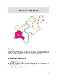
Maps<br />
The accompanying area Maps show <strong>analysis</strong> <strong>of</strong>:<br />
• Hierarchy – the location <strong>of</strong> open spaces categorised according to the <strong>London</strong><br />
Planning Advisory Committee (LPAC) size based hierarchy.<br />
• Function – the main functions or types <strong>of</strong> open space e.g. parks <strong>and</strong> gardens;<br />
recreation ground; cemetery; allotment etc.<br />
• Quality – an assessment <strong>of</strong> the overall quality <strong>of</strong> the open space, considering<br />
l<strong>and</strong>scape quality, condition etc.<br />
• Opportunities – identifies opportunities to improve access to open space, restore<br />
views, remove barriers to access etc.<br />
Audit <strong>of</strong> Current Provision<br />
NAME AREA FUNCTION LPAC PRIORITY<br />
GARRICK LAWN 0.37 Park S 40<br />
BELL HILL 0.14 Open Space S 44<br />
BEN ALLEY 0.04 Open Space S 24<br />
HAMPTON COURT GREEN 1.54 Open Space S<br />
KENTON BOAT YARD (THAMES ST) 0.12 Open Space S 32<br />
LINEAR WALK (Old Farm Road) 0.19 Open Space S/Linear 54<br />
MANOR GDNS (Highways) 0.36 Open Space S 21<br />
MAPLE CLOSE OPEN SPACE 0.16 Open Space S 28<br />
NURSERY GREEN 1.42 Open Space S 48<br />
PANTILE BRIDGE 0.12 Open Space S 40<br />
PARTRIDGE GREEN 0.50 Open Space S 48<br />
ST ALBANS HAMPTON RIVERSIDE 1.26 Open Space S 36<br />
UXBRIDGE ROAD (Highways) 0.12 Open Space S 21<br />
BUCKINGHAM PARK 7.73 Recreation<br />
Ground<br />
CARLISLE PARK 4.26 Recreation<br />
Ground<br />
HATHEROP PARK 8.42 Recreation<br />
Ground<br />
L 99<br />
L Key 60<br />
LOC 136<br />
11
NAME AREA FUNCTION LPAC PRIORITY<br />
HOLLY ROAD RECREATION 0.95 Recreation S 63<br />
GROUND<br />
Ground<br />
ARUNDEL CLOSE WILDLIFE SITE 0.17 Semi-natural S 28<br />
BEVEREE WILDLIFE SITE, HAMPTON 0.55 Semi-natural L 21<br />
BUSHY PARK 253.77 Semi-natural M<br />
OAK AVENUE CONSERVATION AREA 2.00 Semi-natural L 24<br />
HAMPTON CEMETERY 1.08 Cemetery Not LPAC 35<br />
S<br />
ST JAMES CHURCH 0.73 Cemetery Not LPAC 21<br />
L<br />
BUCKINGHAM PARK PLAYGROUND Playground PG 72<br />
CARLISLE PARK J Playground PG 60<br />
CARLISLE PARK S Playground PG 60<br />
HAMPTON SHOPPING CENTRE 0.01 Playground PG 56<br />
PLAYGROUND<br />
HATHEROP PARK PLAYGROUND Playground PG 168<br />
HOLLY RD PLAYGROUND Playground PG 70<br />
NURSERY GREEN PLAYGROUND Playground PG 84<br />
HAMPTON VILLAGE GREEN 1.02 Sports Ground S 27<br />
HAMPTON WAR MEMORIAL 0.01 Memorial Not LPAC 21<br />
S<br />
HAMPTON WICK MEMORIAL 0.02 Memorial S 21<br />
HAMPTON HILL LIBRARY 0.04 Library Not LPAC 49<br />
HAMPTON WICK LIBRARY 0.03 Library S 35<br />
ROSE HILL LIBRARY (HAMPTON 0.44 Library Not LPAC 21<br />
LIBRARY)<br />
HATHEROP ROAD 2.70 Allotment Not LPAC 56<br />
TWICKENHAM (GOLF COURSE) 27.22 Private D 42<br />
12
Analysis <strong>of</strong> access to parks <strong>and</strong> open spaces<br />
100% <strong>of</strong> the area is within 3.2 km <strong>of</strong> a metropolitan/regional park, Richmond Park.<br />
94% <strong>of</strong> the area is within 1.2 km <strong>of</strong> a district open space.<br />
96% <strong>of</strong> the area is within 400m <strong>of</strong> a local open space<br />
79% <strong>of</strong> the area is within 400 metres <strong>of</strong> an equipped playground<br />
Note this <strong>analysis</strong> does not take into account GLA advice which recommends that a 10<br />
minute rail journey or 15 minute bus journey can also increase the catchment area <strong>of</strong><br />
larger parks.<br />
Commentary <strong>and</strong> Local Considerations <strong>and</strong> Issues<br />
A key issue is the relatively large number <strong>of</strong> young people, particularly in the <strong>Hampton</strong><br />
Nursery L<strong>and</strong>s area. A small minority have caused a distinct local concern about crime<br />
<strong>and</strong> anti-social behaviour.<br />
Opportunities to address issues.<br />
• Addressing anti social behaviour by working with policing agencies, parks <strong>and</strong> open<br />
spaces providers to provide positive diversionary activities for young people.<br />
Recommendations/Priorities for <strong>Hampton</strong> <strong>and</strong> <strong>Hampton</strong> <strong>Hill</strong><br />
Following <strong>analysis</strong> the following sites/priorities have been identified:<br />
• Treat Carlisle Park as a Key Park<br />
• Work towards staffing <strong>and</strong> making improvements to Hatherop Park, to develop as a<br />
Key Park in order to partially compensate for lack <strong>of</strong> a District Park in these areas.<br />
Install challenging adventure play equipment <strong>and</strong> positive youth facilities e.g. youth<br />
shelters at priority sites e.g. Hatherop Park, which is identified as one <strong>of</strong> the top 10<br />
<strong>Borough</strong> priorities.<br />
• Carry out priority improvements identified by the Disability Access Audit<br />
• Ensure that development <strong>of</strong> disused water board l<strong>and</strong> is developed sensitively,<br />
retaining significant open space <strong>and</strong> improving access <strong>and</strong> linkages<br />
• Improve knowledge <strong>of</strong> open space opportunities through marketing/signage<br />
improvements, e.g. route from Hatherop to Buckingham Park via Water Board l<strong>and</strong>.<br />
Add to signage scheme<br />
• Explore joint marketing <strong>of</strong> educational activities at Bushy Park <strong>and</strong> Garrick's Temple<br />
• Explore provision <strong>of</strong> legal public access beside the Longford River<br />
13