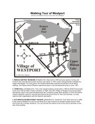
Kingston to Cataraqui Trail to Ottawa - Rideau Heritage Route
Kingston to Cataraqui Trail to Ottawa - Rideau Heritage Route
Kingston to Cataraqui Trail to Ottawa - Rideau Heritage Route

Create successful ePaper yourself
Turn your PDF publications into a flip-book with our unique Google optimized e-Paper software.
<strong>Kings<strong>to</strong>n</strong> <strong>to</strong> <strong>Cataraqui</strong> <strong>Trail</strong> <strong>to</strong> <strong>Ottawa</strong><br />
(191 km without side trips)<br />
The following are directions for a self-guided bicycle <strong>to</strong>ur from <strong>Kings<strong>to</strong>n</strong> <strong>to</strong> <strong>Ottawa</strong> via<br />
the<strong>Cataraqui</strong> <strong>Trail</strong>. If you want an all paved road <strong>to</strong>ur, then please see the Grand Tour -<br />
<strong>Kings<strong>to</strong>n</strong> <strong>to</strong> <strong>Ottawa</strong>. Depending on your skill (stamina) as a bicycler, for the average<br />
bicycler, this is a hard one day, or relaxing two day journey. Please note that the<br />
kilometre distances are only approximate, they have been measured off a map. The<br />
road portion of this <strong>to</strong>ur are on lower traffic paved back roads. The <strong>Cataraqui</strong> <strong>Trail</strong><br />
follows an abandoned railway bed, so it is flat with a few rough sections (see the Cycling<br />
Notes on the <strong>Cataraqui</strong> <strong>Trail</strong> Website).<br />
Place names with links will lead you <strong>to</strong> a map and description of that community.<br />
Highlights of this trip outside of the many attractions in <strong>Kings<strong>to</strong>n</strong> and <strong>Ottawa</strong> include the<br />
<strong>Rideau</strong> Canal Waterway (s<strong>to</strong>ps at several lockstations), the scenery along the <strong>Cataraqui</strong><br />
<strong>Trail</strong>, the beautiful villages of Portland, Merrickville, Kars and Manotick and the<br />
interesting variety in the Town of Smiths Falls. Plus of course the lovely scenery along<br />
the rural back roads.<br />
Symbol Legend<br />
<strong>Route</strong> Arrow -<br />
continue along<br />
main route<br />
Right or<br />
Left Turn<br />
Arrow<br />
Side Loop - a<br />
side trip off the<br />
main route<br />
S<strong>to</strong>p of<br />
Interest<br />
Bicycle <strong>Route</strong> - where this<br />
route intersects another<br />
bicycle route<br />
<strong>Kings<strong>to</strong>n</strong> <strong>to</strong> <strong>Ottawa</strong> <strong>Route</strong> Directions<br />
Km Location Description<br />
0 <strong>Kings<strong>to</strong>n</strong><br />
Follow Montreal Street, north, under Hwy 401, <strong>to</strong><br />
<strong>Kings<strong>to</strong>n</strong> Mills Road. Note that Montreal Street turns<br />
in<strong>to</strong> County Road 11.<br />
Note: A more direct route, but one with more traffic and<br />
you'll miss the <strong>Kings<strong>to</strong>n</strong> Mills Lockstation, is <strong>to</strong> head out<br />
from <strong>Kings<strong>to</strong>n</strong> along Division Street, which will put you<br />
directly on<strong>to</strong> County Road 10, which the original route<br />
intersects in the Village of Inverary.<br />
8<br />
<strong>Kings<strong>to</strong>n</strong> Mills<br />
(4 km)<br />
Take <strong>Kings<strong>to</strong>n</strong> Mills Road 2 kilometres east <strong>to</strong> the<br />
<strong>Kings<strong>to</strong>n</strong> Mills Lockstation. Beautiful scenery, picnic tables<br />
and washrooms.<br />
8 Cty Rd. 11<br />
Continue along County Road 11 <strong>to</strong> Sunbury. Small<br />
grocery s<strong>to</strong>re in Sunbury. Continue <strong>to</strong> intersection with<br />
County Road 12
20 Cty Rd. 12<br />
24 Cty. Rd. 10<br />
35 Opinicon Road<br />
In Sunbury, turn west on County Road 12. Continue <strong>to</strong><br />
County Road 10 at Inverary (note there is a steep hill at<br />
Collins Lake).<br />
Turn north on<strong>to</strong> County Road 10 and continue <strong>to</strong> the<br />
intersection with the Opinicon Road, about 2 km north of<br />
Perth Road Village (please note that this is located about<br />
1 km north of the intersection of the <strong>Cataraqui</strong> <strong>Trail</strong> with<br />
County Road 10 - this is a smoother route than turning<br />
directly on<strong>to</strong> the <strong>Cataraqui</strong> <strong>Trail</strong> from County Road 10).<br />
Turn east (right) on<strong>to</strong> Opinicon Road and take it about 1<br />
km <strong>to</strong> Herm Johnson Road.<br />
36<br />
Herm Johnson<br />
Road<br />
Turn north (left) on<strong>to</strong> Herm Johnson Road and follow it<br />
just a short distance <strong>to</strong> the <strong>Cataraqui</strong> <strong>Trail</strong>.<br />
36 <strong>Cataraqui</strong> <strong>Trail</strong><br />
51.5 Chaffeys<br />
Locks<br />
Turn east on<strong>to</strong> the <strong>Cataraqui</strong> <strong>Trail</strong> and take it <strong>to</strong><br />
Chaffeys Locks. Note that as of this writing you will find<br />
loose slag for the first kilometre of the trail past Herm<br />
Johnson Road so you might have <strong>to</strong> walk your bike this<br />
distance.<br />
At Chaffeys, s<strong>to</strong>p for a bit <strong>to</strong> take in the locks, the<br />
beautiful grounds of the Opinicon Resort Hotel, visit<br />
the Chaffeys Lockmasters House Museum. Take time out<br />
for a <strong>to</strong>ur of Opinicon Lake aboard "Chuckles", a lovely<br />
1940s cruiser (<strong>Rideau</strong> Canal Boat Tours). To get <strong>to</strong><br />
Chaffeys, you might find that it is easiest <strong>to</strong> exit the<br />
<strong>Cataraqui</strong> <strong>Trail</strong> at Indian Lake Road and take Opinicon<br />
Road in<strong>to</strong> Chaffeys (less than 1 km away).<br />
51.5 <strong>Cataraqui</strong> <strong>Trail</strong> Continue along the <strong>Cataraqui</strong> <strong>Trail</strong> <strong>to</strong> County Road 42<br />
65<br />
Forfar Side<br />
Trip<br />
(2 km)<br />
A short 1 km jaunt <strong>to</strong> the west down County Road 42 will<br />
bring you <strong>to</strong> ForFar, home of the Forfar Cheese Fac<strong>to</strong>ry.<br />
Pick up a variety of delicious cheeses, including fresh<br />
(squeaky) curd cheese.<br />
65 <strong>Cataraqui</strong> <strong>Trail</strong><br />
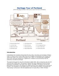
70 Portland<br />
70 <strong>Cataraqui</strong> <strong>Trail</strong><br />
85.5 Toledo<br />
Alternate<br />
Continue along the <strong>Cataraqui</strong> <strong>Trail</strong> from Country Road<br />
42 <strong>to</strong> Portland Station Road.<br />
You can exit the <strong>Cataraqui</strong> <strong>Trail</strong> at Portland Station Road<br />
and take it in<strong>to</strong> Portland. Once you've "done" Portland,<br />
you can return <strong>to</strong> the <strong>Cataraqui</strong> <strong>Trail</strong> via this route.<br />
Continue east along the <strong>Cataraqui</strong> <strong>Trail</strong> <strong>to</strong> County Road<br />
1 (Anglican Church Road - just past Lombardy Station).<br />
A lower traffic alternative <strong>to</strong> passing through Smiths Falls<br />
is <strong>to</strong> exit the <strong>Cataraqui</strong> <strong>Trail</strong> here and head south on<br />
County Road 1 <strong>to</strong> Toledo, and from there <strong>to</strong> Merrickville<br />
where it joins the original route. See the end of this
section for details of this route. Or, continue on <strong>to</strong> Smiths<br />
Falls where highlights will include a fast food strip (incl.<br />
Tim Hor<strong>to</strong>ns) and the <strong>Rideau</strong> Canal Museum.<br />
85.5 <strong>Cataraqui</strong> <strong>Trail</strong><br />
95 Smiths Falls<br />
Continue east along the <strong>Cataraqui</strong> <strong>Trail</strong> <strong>to</strong> its end in<br />
Smiths Falls<br />
The <strong>Cataraqui</strong> <strong>Trail</strong> ends behind the Harveys Restaurant<br />
in Smiths Falls.<br />
95<br />
95.5<br />
Lombard<br />
Street<br />
Lock &<br />
Museum Side<br />
Trip<br />
(2 km)<br />
The quickest, but busiest traffic route is <strong>to</strong><br />
follow Lombard Street (Highway 15) <strong>to</strong> the lights at<br />
Brockville Street<br />
From Harveys/Tim Hor<strong>to</strong>ns - follow Lombard Street east<br />
<strong>to</strong> the lights at Abbott Street. Turn north on Abbott<br />
Street, continue across the swing bridge and turn west<br />
on the road leading in<strong>to</strong> the Detached Lockstation and<br />
the Bascule Bridge. Once you seen those, continue<br />
north on Abbott <strong>to</strong>Strathcona Street (next street north).<br />
Turn east on Strathcona and follow it 3 block<br />
<strong>to</strong> Confederation Driveand follow Confederation across<br />
the bridge. There you will find a walkway (north side)<br />
leading <strong>to</strong> the <strong>Rideau</strong> Canal Museum and the Smiths<br />
Falls Combined Lock (south side). Once you've done<br />
those, turn south on Beckwith Street and continue <strong>to</strong> the<br />
first set of lights at the south end of the bridge. Turn left<br />
on<strong>to</strong> Jasper Avenue.<br />
96 Jasper Avenue<br />
99 Old Slys Locks<br />
From the lights at the Beckwith Street/Brockville Street<br />
intersection, continue east on<strong>to</strong> Jasper Avenue and<br />
follow it <strong>to</strong> Old Slys Road (the road will simply curve <strong>to</strong><br />
the left on<strong>to</strong> Old Slys Road). Continue <strong>to</strong> the locks at Old<br />
Slys.<br />
Old Slys is another lovely <strong>Rideau</strong> lock. Picnic tables and<br />
washrooms.<br />
99<br />
111<br />
111<br />
County Road<br />
43<br />
Kilmarnock<br />
Lock Side Trip<br />
(2 km)<br />
County Road<br />
43<br />
From Old Slys, turn east on<strong>to</strong> County Road 43 and<br />
continue east <strong>to</strong> Kilmarnock.<br />
Kilmarnock Lock - a peaceful rural lock with a lovely<br />
wooden swing bridge. Picnic tables and washrooms.<br />
Continue east on County Road 43 <strong>to</strong> Merrickville<br />
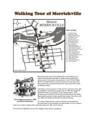
123 Merrickville<br />
Merrickville is well worth a s<strong>to</strong>p. Accommodations,<br />
groceries, restaurants, and many shopping opportunities.<br />
Visit the Blockhouse and the locks. While you are in<br />
Blockhouse Park, s<strong>to</strong>p in at The Depot, run by Friends of<br />
the <strong>Rideau</strong> and pick up an interesting <strong>Rideau</strong> book. Take<br />
a boat <strong>to</strong>ur of the <strong>Rideau</strong> on the electric cruise boat,
123<br />
125<br />
127<br />
127<br />
County Road<br />
43<br />
County Road<br />
23<br />
Upper<br />
Nicholsons<br />
Locks<br />
County Road<br />
23<br />
the Harriet By.<br />
Follow County Road 43 <strong>to</strong> the intersection with County<br />
Road 23 (<strong>to</strong> Burritts Rapids)<br />
Turn north on<strong>to</strong> County Road 23 (River Road).<br />
Continue <strong>to</strong> Upper Nicholsons Lockstation.<br />
A lovely lockstation with swing bridge. Picnic tables and<br />
washrooms.<br />
Continue along County Road 23 <strong>to</strong> Burritts Rapids<br />
131 Burritts Rapids<br />
Burritts Rapids is one of the oldest communities on the<br />
<strong>Rideau</strong>. If you feel like a hike <strong>to</strong> stretch your legs, try the<br />
Tip <strong>to</strong> Tip <strong>Trail</strong> (start from the Burritts Rapids<br />
Lockstation).<br />
131<br />
143<br />
143<br />
County Road<br />
23<br />
Kemptville<br />
(7 km)<br />
County Road<br />
44<br />
Continue along County Road 23 <strong>to</strong> its intersection with<br />
County Road 44<br />
The <strong>to</strong>wn of Kemptville, only 3.5 km away, offers several<br />
services, including a fast food strip with a Tim Hor<strong>to</strong>ns<br />
(turn south at the intersection with County Road 43).<br />
Turn west on<strong>to</strong> County Road 44 and take it across the<br />
<strong>Rideau</strong> River <strong>to</strong> its intersection with County Road 5<br />
144 County Road 5<br />
150 Dilworth Road<br />
Turn north on<strong>to</strong> County Road 5 and take it <strong>to</strong> the<br />
Dilworth Road. Note that you will pass by <strong>Rideau</strong> River<br />
Provincial Park<br />
Turn east on<strong>to</strong> Dilworth Road and take it <strong>to</strong> the Baxter<br />
Conservation Area<br />
153<br />
153<br />
Baxter<br />
Conservation<br />
Area<br />
County Road<br />
13<br />
Conservation areas offer picnic tables and washrooms. A<br />
small day fee applies.<br />
After leaving Baxter Conservation area, turn north<br />
on<strong>to</strong>County Road 13 and take it <strong>to</strong> Kars.<br />
161 Kars<br />
The Village of Kars is a small place with few amenities but<br />
lovely ambiance.<br />
161<br />
County Road<br />
13<br />
Continue along County Road 13 (<strong>Rideau</strong> Valley<br />
Drive) <strong>to</strong> Manotick<br />
170 Manotick<br />
Manotick offers a variety of services. Be sure <strong>to</strong> take time<br />
out <strong>to</strong> visit his<strong>to</strong>ric Watson's Mill.<br />
170 County Road 8 Turn east on<strong>to</strong> Bridge Street and cross the two bridges.
Continue straight, along County Road 8 <strong>to</strong> Spratt Road.<br />
172 Spratt Road<br />
Turn north on Spratt Road and continue along <strong>to</strong> its<br />
intersection with Armstrong Road<br />
176<br />
178<br />
Armstrong<br />
Road<br />
Limebank<br />
Road<br />
Turn east on<strong>to</strong> Armstrong Road and take it <strong>to</strong> Limebank<br />
Road.<br />
Turn north on<strong>to</strong> Limebank Road and take it <strong>to</strong> River<br />
Road (County Road 19)<br />
183 River Road<br />
Limebank Road ends at River Road, so follow River<br />
Roadnorth <strong>to</strong> Hunt Club Road. Note that vehicle traffic<br />
will be an issue until you hook up with one of the <strong>Ottawa</strong><br />
Cycling Paths.<br />
185<br />
189<br />
189<br />
190<br />
Riverside<br />
Drive<br />
Mooney's Bay<br />
Park<br />
Riverside<br />
Drive<br />
Hogs Back<br />
Road<br />
Continue north, crossing Hunt Club Road <strong>to</strong> Riverside<br />
Drive. Continue along Riverside Drive <strong>to</strong> Mooney's Bay<br />
Park<br />
A City of <strong>Ottawa</strong> Park on the shores of the <strong>Rideau</strong> River.<br />
Continue north along Riverside Drive <strong>to</strong> Hogs Back<br />
Road.<br />
Turn west on<strong>to</strong> Hogs Back Road and continue <strong>to</strong> Hogs<br />
Back Lockstation<br />
191 Hogs Back<br />
This marks the end of the route description. At Hogs Back<br />
you'll find an <strong>Ottawa</strong> Bicycle Path. Continue on the<br />
bicycle path in<strong>to</strong> <strong>Ottawa</strong>. Hogs Back offers picnic tables<br />
and washrooms. This spot also marks where the <strong>Rideau</strong><br />
Canal splits from the <strong>Rideau</strong> River. Take time <strong>to</strong> view the<br />
Hogs Back Falls.<br />
Toledo Alternate - <strong>Cataraqui</strong> <strong>Trail</strong> <strong>to</strong> Merrickville<br />
(this will bypass Smiths Falls via Toledo and Jasper)<br />
85.5 County Road 1<br />
Exit the <strong>Cataraqui</strong> <strong>Trail</strong> where it intersects with County<br />
Road 1 (Anglican Church Road) and follow it south <strong>to</strong><br />
Toledo.<br />
99 Toledo Gas station with groceries. Limited services.<br />
99 County Road 8<br />
In Toledo, turn east on<strong>to</strong> County Road 8 and take it <strong>to</strong><br />
the intersection with County Road 29<br />
100<br />
107<br />
County Road<br />
29<br />
County Road<br />
16<br />
Just past Toledo turn north on<strong>to</strong> County Road 29 and<br />
take it <strong>to</strong> County Road 16, the exit for Jasper<br />
Turn east on<strong>to</strong> County Road 16 and follow it all the way<br />
<strong>to</strong> Jasper
112<br />
County Road<br />
16<br />
From Jasper, continue along County Road 16 <strong>to</strong><br />
Merrickville<br />
127 Merrickville At Merrickville, this alternate route rejoins the main route.