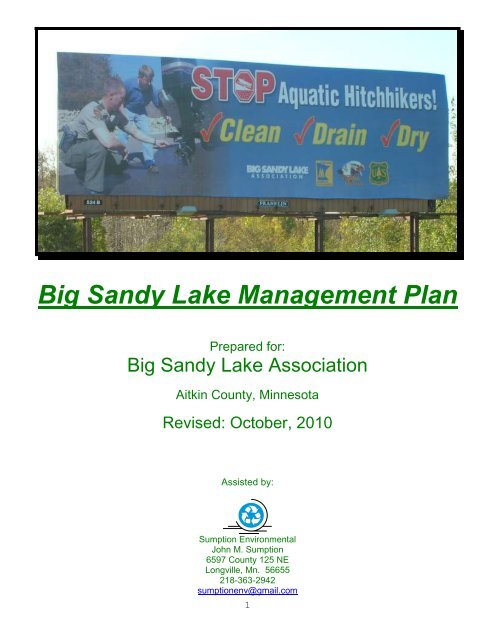
Big Sandy Lake Management Plan - Big Sandy Lake Association
Big Sandy Lake Management Plan - Big Sandy Lake Association
Big Sandy Lake Management Plan - Big Sandy Lake Association

Create successful ePaper yourself
Turn your PDF publications into a flip-book with our unique Google optimized e-Paper software.
<strong>Big</strong> <strong>Sandy</strong> <strong>Lake</strong> <strong>Management</strong> <strong>Plan</strong><br />
Prepared for:<br />
<strong>Big</strong> <strong>Sandy</strong> <strong>Lake</strong> <strong>Association</strong><br />
Aitkin County, Minnesota<br />
Revised: October, 2010<br />
Assisted by:<br />
Sumption Environmental<br />
John M. Sumption<br />
6597 County 125 NE<br />
Longville, Mn. 56655<br />
218-363-2942<br />
sumptionenv@gmail.com<br />
1
Table of Contents<br />
<strong>Management</strong> <strong>Plan</strong> for <strong>Big</strong> <strong>Sandy</strong> <strong>Lake</strong><br />
Introduction ........................................................................................................................................... 3<br />
A Brief History of <strong>Big</strong> <strong>Sandy</strong> <strong>Lake</strong> ......................................................................................................... 3<br />
History of the <strong>Big</strong> <strong>Sandy</strong> <strong>Lake</strong> <strong>Association</strong> ........................................................................................... 5<br />
Accomplishments .............................................................................................................................. 7<br />
Physical Characteristics and Location of <strong>Big</strong> <strong>Sandy</strong> <strong>Lake</strong> .................................................................... 8<br />
A. <strong>Lake</strong> Characteristics..................................................................................................................... 8<br />
B. Watershed Characteristics ........................................................................................................... 9<br />
C. Precipitation ............................................................................................................................... 10<br />
D. Water Level ................................................................................................................................ 11<br />
E. Water Quality ............................................................................................................................. 11<br />
F. Fisheries ..................................................................................................................................... 13<br />
G. Native Vegetation ...................................................................................................................... 15<br />
<strong>Big</strong> <strong>Sandy</strong> <strong>Lake</strong> Shoreland Revegetation Project ........................................................................ 15<br />
Continued Projects ...................................................................................................................... 16<br />
DNR Aquatic <strong>Plan</strong>t Survey ........................................................................................................... 17<br />
Value of Aquatic <strong>Plan</strong>ts to the <strong>Lake</strong> Ecosystem ........................................................................... 19<br />
Recommendations ....................................................................................................................... 19<br />
H. Wildlife ....................................................................................................................................... 20<br />
Wildlife Habitat Survey ................................................................................................................. 20<br />
I. Invasive Species ......................................................................................................................... 21<br />
Background .................................................................................................................................. 21<br />
<strong>Lake</strong> <strong>Association</strong> Aquatic <strong>Plan</strong>t Surveys ...................................................................................... 21<br />
Land Use and zoning .......................................................................................................................... 24<br />
State Regulations ........................................................................................................................ 25<br />
Aitkin County Standards .............................................................................................................. 25<br />
Managing water surface use conflicts ................................................................................................. 28<br />
Public water access ............................................................................................................................ 29<br />
Summary of Visioning Session ........................................................................................................... 31<br />
Prioritized Goals and Action <strong>Plan</strong> ........................................................................................................ 32<br />
Focus Area #1---Fisheries <strong>Management</strong> ......................................................................................... 32<br />
Focus Area #2---Aquatic Vegetation Preservation/Invasive Species Control .................................. 33<br />
Focus Area #3---Water Quality ........................................................................................................ 34<br />
Other BSLA Goals: .......................................................................................................................... 36<br />
Appendix A-MPCA Total Maximum Daily Load Report—<strong>Big</strong> <strong>Sandy</strong> <strong>Lake</strong> .......................................... 37<br />
Appendix B—Minnesota DNR Fisheries Reports—<strong>Big</strong> <strong>Sandy</strong> <strong>Lake</strong> ................................................... 38<br />
Glossary .............................................................................................................................................. 43<br />
Common Biological or Chemical Abbreviations .................................................................................. 46<br />
Guide to Common Acronyms .............................................................................................................. 47<br />
State and Federal Agencies ............................................................................................................ 47<br />
Regional, watershed, community development, trade and advocacy groups .................................. 47<br />
Codes and Regulations ................................................................................................................... 48<br />
2
Mission: It is the mission of the <strong>Big</strong> <strong>Sandy</strong> <strong>Lake</strong> <strong>Association</strong> to ensure<br />
the enjoyable and safe use of the lake for a diversity of activities while<br />
helping to protect the water quality and shorelines for future<br />
generations.<br />
Introduction<br />
In March 2005 the <strong>Big</strong> <strong>Sandy</strong> <strong>Lake</strong> <strong>Association</strong> (BSLA) participated in the Initiative Foundation’s<br />
Healthy <strong>Lake</strong>s and Rivers Partnership program along with seven other <strong>Lake</strong> <strong>Association</strong>s in Itasca<br />
and Aitkin Counties. BSLA representatives attended two days of training on strategic planning,<br />
communication, and nonprofit group leadership. Representatives of many state and local agencies,<br />
as well as nonprofit organizations also attended the training sessions in order to offer their assistance.<br />
This document is intended to:<br />
Build on the Healthy <strong>Lake</strong>s and Rivers Program work done in 2005<br />
Create a record of historic and existing conditions and influences on <strong>Big</strong> <strong>Sandy</strong> <strong>Lake</strong><br />
Identify the goals of the <strong>Big</strong> <strong>Sandy</strong> <strong>Lake</strong> community<br />
Help prioritize those goals<br />
Guide citizen action and engagement in the priority action areas<br />
Clearly, state agencies and local units of government have a vital role and responsibility in managing<br />
our surface waters and other natural resources, but this <strong>Lake</strong> <strong>Management</strong> <strong>Plan</strong> is intended to be an<br />
assessment of what we as citizens can influence, what our desired outcomes are, and how we will<br />
participate in shaping our own destiny.<br />
This <strong>Lake</strong> <strong>Management</strong> <strong>Plan</strong> is also intended to be a ―living document.‖ As new or better information<br />
becomes available, and as we accomplish our goals or discovered that alternative strategies are<br />
needed, it is our intent to update this plan so that it continues to serve as a useful guide to future<br />
leaders.<br />
In discussing lake management issues, it is impossible to avoid all scientific or technical terms. We<br />
have tried to express our goals, measures of success, and other themes as simply and clearly as<br />
possible, but have included a glossary of common limnological terms at the end of the plan to assist<br />
the reader. Limnology is the study of lake conditions and behavior.<br />
Finally, we would like to thank the Healthy <strong>Lake</strong>s & Rivers Partnership program, Aitkin County<br />
Environmental Services, Aitkin County Sheriff’s Office, the Aitkin County Soil & Water Conservation<br />
District, the Minnesota Department of Natural Resources, the Minnesota Pollution Control Agency<br />
and the U.S. Army Corps of Engineers for their input to and support of this plan.<br />
A Brief History of <strong>Big</strong> <strong>Sandy</strong> <strong>Lake</strong><br />
by Robert Harder, BSLA member and lake resident<br />
It is reported from different sources that the Ojibwe had at least two names for the lake—―Ga-mitawa-ga-gmag‖<br />
(place of bare sand lake) and ―Kom-tong-gog-o-mog‖ (sandy shores). Regardless of<br />
what they called it, native peoples used <strong>Big</strong> <strong>Sandy</strong> for millennia as an important crossroads in the<br />
trade connection between the Mississippi River valley and the Great <strong>Lake</strong>s region via the Savanna<br />
Portage. It was an important fishery and wild rice center. When white men arrived, the local Ojibwe<br />
band summered in <strong>Big</strong> <strong>Sandy</strong> and wintered in Rice <strong>Lake</strong> (Minnewawa).<br />
3
As early as 350 years ago, in the late 1600’s, references to ―Lac du Sable‖ or sometimes ―Lac des<br />
Sables‖ (lake of the sand) appeared on European maps and the virtues of the potentials for fur<br />
harvesting were eagerly discussed in the salons of London and Paris. The reason it was so important<br />
boiled down to the Savanna Portage.<br />
Later, missionaries and explorer passed through <strong>Big</strong> <strong>Sandy</strong> <strong>Lake</strong>—Nicollet, Perrault, Sieur Duluth,<br />
and David Thompson. The Englishman, Thompson, established the North West Company Fur<br />
Trading Post in 1794 at Brown’s Point, thus creating the first real European settlement on <strong>Big</strong> <strong>Sandy</strong>.<br />
In 1806, Lt. Zebulon Pike, in a follow-up mission to the Lewis and Clark expedition of 1803, was sent<br />
by President Jefferson to explore the upper Mississippi River valley. Pike spent 12 days at <strong>Big</strong><br />
<strong>Sandy</strong> in January of 1806 on his way to explore the source of the Mississippi.<br />
In 1818, subsequent to the terms agreed upon by Britain and the United States ending the war of<br />
1812-15, the American Fur Company took over the <strong>Sandy</strong> <strong>Lake</strong>s Post from the Northwest Company,<br />
ending Britain’s sway over <strong>Big</strong> <strong>Sandy</strong>. By 1820, John Jacob Astor’s American Fur Co. controlled<br />
nearly all of the once British posts in what is now Minnesota.<br />
In 1831, an independent trader named William Aitkin took charge of the <strong>Sandy</strong> <strong>Lake</strong> Post, staying as<br />
its head for about 15 years. His departure roughly coincided with the demise of the beaver hat, ergo<br />
the end of the fur trading era.<br />
In 1832, Aitkin’s friend, Frederick Ayer, a Protestant clergyman, joined Aitkin to establish a school at<br />
the <strong>Sandy</strong> <strong>Lake</strong> post for the Indian and half-breed children of the Post’s employees. This is generally<br />
considered by most historians to be the first school in Minnesota. In 1833, Ayer’s fellow missionary,<br />
Edmund Ely, took over the school. Ely was a great success. Adults, white and half-breed, began<br />
attending his school, learning and listening to his preaching and song leading. Ayer and Ely moved<br />
on further north after a couple of years and the school was abandoned.<br />
Other explorers soon arrived at <strong>Sandy</strong> <strong>Lake</strong>, including Lewis Cass and Henry Schoolcraft in 1820,<br />
Beltrami passed through in 1823. Schoolcraft came through again in 1832 on his way to discover the<br />
source of the Mississippi, a lake which he named ―Itasca‖ (from Veritas Caput—latin for ―true source‖)<br />
Joseph Nicollet arrived in 1836 when he was working on his famous map of the entire old Northwest<br />
Territory/Upper Midwest.<br />
Beginning in the 1840’s, and as a result of the end of the fur trade, nearly all commerce, trade, and<br />
related activity largely ceased at <strong>Big</strong> <strong>Sandy</strong>. Only a handful of Indians (decimated by disease),<br />
mixed bloods, and white ―hermits‖ lived around the lake for the next 30 years or so. One of the<br />
hermits was Bill Horn, who lived on the bay that still carries his name, though slightly distorted due to<br />
a printing error by real estate developers—Bill Horn became ―Bell Horn‖ Bay.<br />
In the 1880’s and 90’s, the loggers came, Weyerhauser and many independents, along with a few<br />
settlers. It was then that the Indian stories around <strong>Big</strong> <strong>Sandy</strong> were first recorded, especially the tales<br />
surrounding ―Battle Island‖, scene of a number of skirmishes that occurred between the Ojibwe and<br />
the Dakota’s for perhaps 100 years. The first battle apparently occurred in the 1840’s. Several<br />
Indians became permanent residents around 1900, one of whom, ―Muckandwaywanee‖ or ―Bed<br />
Muck‖ was so popular that an island was named for him, ―Muck’s Island.<br />
In the 1870’s, when the Northern Pacific Railroad had built its trans-continental railroad beginning at<br />
Carlton, Mn., the railroad was awarded very large blocks of land grants. <strong>Sandy</strong> <strong>Lake</strong> was included in<br />
the grant by the U.S. Congress, which is the reason today many lake property owners find in their<br />
4
land abstracts a record of NP ownership. Railheads were established at McGregor and Tamarack,<br />
and much of the timber extracted during the logging era around <strong>Sandy</strong> was shipped from those two<br />
sites.<br />
World War I brought new roads into the area. Automobile transportation was changing everything.<br />
At the same time, the timber was giving out—all the marketable wood and been harvested. Loggers<br />
converted their timber camps to hunting and fishing shacks for wealthy Twin Cities sportsmen.<br />
Several homesteaders around the lake saw opportunities in opening a regular hunting-fishing resort.<br />
Research shows that the first in this category were Elmer and Elisele LeVasseur’s ―Pine Beach‖,<br />
which opened in 1919—now the CMA camp.<br />
While resorts began popping up in the 1920’s-30’s, developers like Hay-Knight and the Greater <strong>Lake</strong>s<br />
Company of Minneapolis began buying large tracts of land and platting them. Hay-Knight’s 1921 ―<strong>Big</strong><br />
<strong>Sandy</strong> <strong>Lake</strong> Highlands‖ project was the first platted land sold on the lake.<br />
Two interesting side lights to the Hay Knight’s development of the early 1920’s:<br />
1. Their second pamphlet advertising the lake shore lots had a spelling error—―Bill Horn Bay‖<br />
became ―Bell Horn Bay, a mistake we still live with today.<br />
2. Hay-Knights hired Tingdale Realty of Minneapolis to sell the lots. Tingdale’s primary sales<br />
person was Marcus Nelson, this author’s grandfather. According to family lore, circa 1920-21,<br />
Hay-Knights people, Martin Tingdale, and his brother-in-law, Marcus Nelson had a<br />
brainstorming session. It was decided that the name ―<strong>Sandy</strong> <strong>Lake</strong>‖ was too prosaic, plus there<br />
were many <strong>Sandy</strong> <strong>Lake</strong> about, or so it was thought. They therefore decided to add to their<br />
property’s grandeur by renaming the lake ―<strong>Big</strong> <strong>Sandy</strong> <strong>Lake</strong>‖, and so it has remained to this day.<br />
In 1958, there were about 45 resorts operating on the lake. The ―resort era‖ lasted until the early<br />
1960’s, when the land and lakeshore became so valuable that it was more profitable to sell off the<br />
resorts for individual cabin ownership. By the 1970’s, this process was in full swing and only a<br />
handful of resorts continued operating. Today, only ―Hillcrest can still call itself a traditional family<br />
resort.<br />
<strong>Big</strong> <strong>Sandy</strong> <strong>Lake</strong>, as we know it today, was created in 1894, when the Libby Dam was constructed,<br />
one of six built on the upper Mississippi to control water levels downstream. Libby Dam nearly<br />
doubled the size of the original <strong>Sandy</strong> <strong>Lake</strong> (which had sandy shores nearly all the way around with<br />
some beaches sticking out over 100 feet to the waterline, hence the name). Today, those beaches<br />
are under water, the <strong>Sandy</strong> <strong>Lake</strong> Reservoir covering approximately 6,400 acres. Some 970<br />
seasonal and year-around cabins and houses populate the shores of what once was the center of the<br />
major fur trading district in the old Northwest Territory. This rich cultural and historic district is now<br />
one of Minnesota’s premiere water playgrounds. About the author: http://www.robertoharder.com/<br />
History of the <strong>Big</strong> <strong>Sandy</strong> <strong>Lake</strong> <strong>Association</strong><br />
Establishment of the Libby Dam at the north end of <strong>Big</strong> <strong>Sandy</strong> <strong>Lake</strong> in the late 1800’s has played a<br />
key role in the struggle of lakeshore owners to influence decisions affecting the lake.<br />
Jim Mikkelson remembers his father gathering a group of lakeshore owners together in his kitchen in<br />
Minneapolis during the drought of the early 1930’s to plan for ways that they could influence the<br />
government officials to close the dam to raise the level of the lake.<br />
David Laursen, in his book ―A Capital Place‖, tells how a group of local property owners banded<br />
together in the mid 1950’s to form the <strong>Big</strong> <strong>Sandy</strong> <strong>Lake</strong> Improvement <strong>Association</strong> in order to force the<br />
Army Corps of Engineers to change their reservoir management policies.<br />
In the mid 1970’s, local fishermen were concerned about the Minnesota Department of Natural<br />
Resources (DNR) stocking program. Wayne Reed, owner of the Hillcrest Resort had made several<br />
inquiries and felt that his voice was not being heard. It was suggested that an organization<br />
5
epresenting lake residents would have more influence. Curt and Julie Sparks who frequently stayed<br />
next door to Hillcrest in the Mikkelson cabin both worked for the Minnesota Pollution Control Agency.<br />
Curt was involved in the formation of many lake associations as manager in the Water Quality<br />
Division. He prepared bylaws and prepared the filings of the association to the Secretary of State.<br />
About 12 people attend the first meeting of the association which was held at Hillcrest Resort. This<br />
was the first official meeting of the <strong>Big</strong> <strong>Sandy</strong> <strong>Lake</strong> <strong>Association</strong> (BSLA). Wayne Reed was elected<br />
and Gary Hilstrom was vice president. The dues were set at $10. With over $100 raised from dues,<br />
the first newsletter was published which discussed the DNR fish stocking program. T-shirts were<br />
printed as a fund raiser. Cards to inform cabin owners about their onsite septic systems were printed<br />
and distributed. These first year activities continue to be important BSLA programs.<br />
The BSLA quickly found that state agencies were now paying attention to the letters sent by<br />
President Reed. However, the focus of the BSLA was not addressing the larger issues of lake<br />
protection and improvement. The evolution of BSLA had reached a plateau.<br />
In the drought of 1982, the Army Corps of Engineers ordered the Mississippi River Reservoirs opened<br />
to increase river flow in the Twin Cities. The purpose was to allow for barge traffic on the Mississippi<br />
and Minnesota Rivers. Many lake associations including BSLA complained that the damage to the<br />
recreational waters and fishery was not worth the floating of barges in the rivers. This resulted in a<br />
comprehensive study of the water quality of the reservoir system including the first study of <strong>Big</strong> <strong>Sandy</strong>.<br />
In 1989, an airport was proposed near the lake. This stimulated interest in organizing a bigger, more<br />
comprehensive group who would broaden the membership and the scope of the issues considered by<br />
the BSLA. Membership grew and so did the ideas for lake management activities.<br />
Many of the new BSLA members were concerned about the fish kills in Bell Horn Bay. <strong>Lake</strong> weeds in<br />
Fisherman’s Bay concerned those cabin owners and algae blooms were becoming more frequent and<br />
noticeable. Under new leadership, more educational focus was placed on the causes of water quality<br />
degradation. With the results of the Army Corps study, more information about the condition of the<br />
lake was available to BSLA members.<br />
Watershed managers and lake water quality professionals emphasize that lakes are a reflection of<br />
their watersheds. For example, the dark tea colored water in <strong>Big</strong> <strong>Sandy</strong> was formerly thought to be<br />
from iron deposits in the lake. Even the rocks in the lake carry that reddish brown color. Study of the<br />
watershed showed that the color is a tannin that leaches from the organic materials in the vast areas<br />
of wetland feeding the rivers that are tributary to <strong>Big</strong> <strong>Sandy</strong> <strong>Lake</strong>. Watershed investigation was the<br />
only way to learn about influences to the lake and how to protect it from further degradation. BSLA<br />
lacked the ability to address watershed activities that were impacting lake water quality.<br />
After discussion with other lake associations and consultation with the Counties, a commitment to<br />
support the formation of a project team was signed in April of 1993. That same year, the <strong>Big</strong> <strong>Sandy</strong><br />
Area <strong>Lake</strong> Watershed <strong>Management</strong> Project (BSALWMP) was formed to evaluate problems,<br />
opportunities, and actions needed to properly address the concerns over water quality in area lakes.<br />
Bob Guntzburger and Harold Dzuik were key members of the project team, with the assistance of<br />
Steve Hughes from the Aitkin Soil and Water Conservation District. BSALWMP produced a<br />
watershed management plan in 1995. Implementation of the plan requires funding from the Counties,<br />
grants, and donations. Without that support, it is unlikely that the plan will be implemented.<br />
Today, BSLA represents over 50% of lakeshore owners on the lake. The mission of the <strong>Big</strong> <strong>Sandy</strong><br />
<strong>Lake</strong> <strong>Association</strong> is to ―Ensure the enjoyable and safe use of the lake for a diversity of activities<br />
while helping to protect the water quality and shorelines for future generations.”<br />
The <strong>Association</strong> has the following visions for the future:<br />
To protect the water quality of BSL through a monitoring and reporting program and to actively<br />
pursue follow-up activities required to improve and sustain the health of the lake.<br />
To offer experiences and education for the youth of the area in subjects relating to safe<br />
recreational activities on the lake and an appreciation for protecting the BSL Watershed.<br />
To build and maintain on-going relationships with State, County, and local governmental<br />
agencies that relate to issues affecting BSL and its surroundings.<br />
6
To gain expertise in areas that may influence <strong>Big</strong> <strong>Sandy</strong> <strong>Lake</strong>, and communicate that<br />
information all lakeshore owners.<br />
To build and maintain relationships with other organizations and individuals that have similar<br />
objectives, purposes and values.<br />
To establish a significant financial reserve fund for a potential environmental event that could<br />
threaten the health of <strong>Big</strong> <strong>Sandy</strong> <strong>Lake</strong>.<br />
During it’s approximately 30 years as an organization, BSLA members and its Board of<br />
Accomplishments<br />
Directors have donated thousands of hours to projects and activities that improve the quality of lake<br />
life. These include:<br />
Shoreland restoration projects w/BSALWMP.<br />
Invasive species monitoring at boat launches w/DNR & BSLA interns<br />
Invasive species ID workshops- w/DNR and U of M<br />
Secchi depth and phosphorous monitoring w/ MPCA<br />
E 911 emergency signs w/ Aitkin County Sheriff<br />
Eco-education programs w/Rice <strong>Lake</strong> Wildlife Refuge.<br />
Support the <strong>Big</strong> <strong>Sandy</strong> Water Institute, cooperative venture w/ ISD 4 Community ed. & DNR–<br />
free summer-long eco-ed. & water sports activities for kids<br />
Fencing program w/BSALWMP-Exclude livestock from lakes/rivers in the watershed<br />
Work w/ County and owners of a 1000 acre rice farm to create a wild and scenic area—protect<br />
<strong>Sandy</strong> River from phosphorus discharges<br />
Developed a brochure on the area w/McGregor Area Chamber of Commerce.<br />
Activities w/DNR Fisheries on lake issues, support of a slot limit proposal<br />
Neighborhood watch program w/Sheriff’s Dept<br />
BSLA adopted and cleans up a long stretch of County Road 14<br />
BSLA supports and staffs the Shamrock Township annual clean-up days<br />
The BSL Foundation and its activities<br />
Financial assistance to arrive at solutions to McGregor area drainage ditch pollution issues<br />
Newsletters to inform and educate all lakeshore owners<br />
Purchase and placement of navigational buoys<br />
Participation in the development of the Aitkin County Shoreland <strong>Management</strong> Ordinances<br />
Development and maintenance of the Highway 65 overlook<br />
Establishment and operation of a yard waste recycling site<br />
Financial support for the purchase of an underwater sonar unit for the recovery of bodies<br />
Financial support for the 4 th of July fireworks display<br />
Development and maintenance of spawning sites<br />
Development of the <strong>Big</strong> <strong>Sandy</strong> <strong>Lake</strong> <strong>Management</strong> <strong>Plan</strong><br />
The <strong>Big</strong> <strong>Sandy</strong> <strong>Lake</strong> <strong>Association</strong> maintains a website at http://www.bslassociation.org/index.html<br />
7
Physical Characteristics and Location of <strong>Big</strong> <strong>Sandy</strong> <strong>Lake</strong><br />
A. <strong>Lake</strong> Characteristics<br />
<strong>Big</strong> <strong>Sandy</strong> <strong>Lake</strong> (DNR ID#01-0062) is located north of McGregor. The lake is a reservoir system with<br />
variable water flow that fluctuates from year to year. The major tributaries to <strong>Big</strong> <strong>Sandy</strong> <strong>Lake</strong> include<br />
the <strong>Sandy</strong> River, Prairie River, and Tamarack River. Water levels in <strong>Big</strong> <strong>Sandy</strong> <strong>Lake</strong> are controlled by<br />
the U.S. Army Corps of Engineers through operation of the dam at the lake’s outlet. <strong>Big</strong> <strong>Sandy</strong> <strong>Lake</strong><br />
is approximately 6,526 acres in size, with a maximum depth of 84 feet. The littoral area (area with a<br />
depth of 15 feet or less) is approximately 3,085 acres. <strong>Big</strong> <strong>Sandy</strong> <strong>Lake</strong> can generally be divided into<br />
three sections: Webster’s Bay, Bellhorn Bay, and Main Bay. Webster’s Bay is the shallowest of the<br />
three sections, and receives flow from the <strong>Sandy</strong> River. Bellhorn Bay is the deepest section of the<br />
lake, and receives flow from the Prairie River. Main Bay has the greatest surface area of the three<br />
sections, but does not receive direct flow from any of the major rivers in the watershed. The outlet of<br />
<strong>Big</strong> <strong>Sandy</strong> <strong>Lake</strong> is via the <strong>Sandy</strong> River, in the northwest corner of Main Bay. The <strong>Sandy</strong> River<br />
discharges to the Mississippi River less than one mile downstream of <strong>Big</strong> <strong>Sandy</strong> <strong>Lake</strong>. See the<br />
MPCA TMDL Study Report in Appendix A for complete technical information.<br />
8
B. Watershed Characteristics<br />
The <strong>Big</strong> <strong>Sandy</strong> <strong>Lake</strong> watershed is in the Upper Mississippi River Basin and within the Northern <strong>Lake</strong>s<br />
and Forest (NLF) Ecoregion. While <strong>Big</strong> <strong>Sandy</strong> <strong>Lake</strong> is located in Aitkin County, its watershed also<br />
extends east into St. Louis County and Carlton Counties. <strong>Big</strong> <strong>Sandy</strong> <strong>Lake</strong> is a reservoir system,<br />
created by the construction of a dam in 1886. The U.S. Army Corps of Engineers (USACE) is<br />
responsible for dam operations and controls the water level of <strong>Big</strong> <strong>Sandy</strong> <strong>Lake</strong>, which discharges to<br />
the nearby Mississippi River.<br />
9
The <strong>Big</strong> <strong>Sandy</strong> watershed is approximately 260,000 acres (406 square miles) in size. Land use<br />
percentages of the <strong>Big</strong> <strong>Sandy</strong> <strong>Lake</strong> watershed, based on the 2001 National Land Cover Database<br />
(NLCD), are summarized as follows:<br />
54% forest<br />
29% wetland<br />
5.7% pasture/hay/cultivated crops<br />
4.3% grassland<br />
4.1% open water<br />
2.4% developed (low, medium, and high density)<br />
In addition to land use changes from natural conditions, the <strong>Big</strong> <strong>Sandy</strong> watershed has been altered in<br />
other ways. Extensive ditching of wetlands in portions of the watershed has occurred as early as the<br />
early 1900s when an effort was made to establish increased farmlands (MN DNR Fisheries 2002).<br />
More recently, wetlands have been ditched and drained to allow for peat and wild rice farming. The<br />
ditches have likely affected the hydrology and nutrient transport dynamics of the watershed. Ditching<br />
may also lead to increased erosion and transport of soil and sediment within stream and river<br />
channels, as ditching and channeling of natural stream channels and wetlands will increase the peak<br />
flow from storm events. See the MPCA TMDL Study Report in Appendix A for complete watershed<br />
information.<br />
C. Precipitation<br />
In 2002 the Minnesota Pollution Control Agency (MPCA)) completed a <strong>Lake</strong> Assessment Program<br />
(LAP) evaluation of Cedar <strong>Lake</strong>, near Aitkin, MN. The following characterization of precipitation and<br />
local climate was adapted from that report:<br />
10
―Based on State Climatology records, precipitation averages 28 inches (0.66 m) annually in this part<br />
of the state….Evaporation typically exceeds precipitation in this part of the state and averages about<br />
32 inches (0.81 m) per year. Runoff averages about eight inches with 1-in-10-year low and high<br />
values (low and high runoff values which might occur with a frequency of once in ten years) of 3.0<br />
inches and 10.0 inches respectively for this area.‖<br />
Local precipitation during water year 2008 (26.7 inches) was slightly lower than average for the area<br />
(28.1 inches). State Climatologist<br />
D. Water Level<br />
The DNR Division of Waters has historic water level data for <strong>Big</strong> <strong>Sandy</strong> <strong>Lake</strong> from 1899. During the<br />
period of record the lake level has varied 16.84 feet based on 40,727readings (through August, 2010).<br />
In general, water levels decline from May through September, with the exception of a slight increase<br />
in mid-July in response to several storms.<br />
Period of record: 01/01/1899 to 08/11/2010<br />
Highest recorded: 1224.8 ft (05/19/1950)<br />
Lowest recorded: 1207.96 ft (01/20/1921)<br />
Recorded range: 16.84 ft<br />
Last reading: 1216.29 ft (08/11/2010)<br />
Ordinary High Water Level (OHW) elevation: 1216.56 ft<br />
Datum: NGVD 29 (ft)<br />
E. Water Quality<br />
Citizen volunteers from the <strong>Big</strong> <strong>Sandy</strong> <strong>Lake</strong> <strong>Association</strong> have participated in the Minnesota Pollution<br />
Control Agency’s (MPCA) Citizen <strong>Lake</strong> Monitoring Program (CLMP) since 1974, recording secchi disc<br />
transparency – a measure of water clarity. In recent years the <strong>Big</strong> <strong>Sandy</strong> <strong>Lake</strong> CLMP volunteers<br />
11
have included: Jim Carlson, Carmen Knoble, John Nystuen, Mark and Lori Krezowski, and John<br />
Lahoud.<br />
The Total Maximum Daily Load (TMDL) report notes that <strong>Big</strong> <strong>Sandy</strong> <strong>Lake</strong> is currently listed on the<br />
Minnesota Pollution Control Agency’s (MPCA) 2008 303(d) Impaired Waters List due to excessive<br />
nutrients (phosphorus). The lake was first placed on the MPCA’s 303(d) list in 2002. The original<br />
target start date for the TMDL reports was 2006, and the target completion date was 2011. The draft<br />
TMDL report was released for public comment in August, 2010.<br />
The TMDL Report also indicates that summer (June-September) mean Secchi disc transparencies for<br />
<strong>Big</strong> <strong>Sandy</strong> <strong>Lake</strong> are below the NLF ecoregion standard of 2.0 meters for all three bays during the<br />
period of 1983-2008, with the exception of Bellhorn Bay in 1988 (See figure 3-1, appendix A.<br />
Summer mean total phosphorus concentrations are presented in Figure 3-2. Summer average<br />
chlorophyll a concentrations are presented in Figure 3-3.). Average Secchi disc transparencies were<br />
some of the lowest on record for <strong>Big</strong> <strong>Sandy</strong> <strong>Lake</strong> in 2008, even though average concentrations of<br />
chlorophyll a and total phosphorus in 2008 were in the range of concentrations of other recent years.<br />
Plotting individual measurements of Secchi disc transparency against concurrent measurements of<br />
chlorophyll a demonstrates water transparency was generally lower in 2008 when compared to<br />
readings taken when chlorophyll a concentrations were similar. Likewise, Secchi disc transparency<br />
was generally lower in 2008 compared to previous years for similar concentrations of total<br />
phosphorus. For many Minnesota lakes, a strong relationship exists between Secchi disc<br />
transparency, chlorophyll a, and phosphorus concentrations. An examination of available data for <strong>Big</strong><br />
<strong>Sandy</strong> <strong>Lake</strong>, including plotting chlorophyll a versus total phosphorus, reveals there is a relatively<br />
weak relationship between Secchi disc transparency, chlorophyll a, and phosphorus in <strong>Big</strong> <strong>Sandy</strong><br />
<strong>Lake</strong> (See figure 3-6, appendix A).<br />
One possible explanation of the weak relationship between Secchi disc transparency, chlorophyll a,<br />
and total phosphorus is high humic color in <strong>Big</strong> <strong>Sandy</strong> <strong>Lake</strong>. <strong>Big</strong> <strong>Sandy</strong> <strong>Lake</strong> is generally highly<br />
colored, with historic reading ranging from 100 to 300 Platinum-Cobalt Units (PCU). These color<br />
readings represent high concentrations of light-absorbing dissolved organic compounds that can<br />
severely reduce water transparency. Typical color readings for lakes in the NLF ecoregion are in the<br />
range of 10-35 PCU (MN DNR Fisheries 2002). <strong>Big</strong> <strong>Sandy</strong> has a large watershed with a high<br />
percentage of wetlands, including large areas of peatlands. The decaying organic matter in these<br />
wetlands and peatlands are a significant source of dissolved organic compounds, as evidenced by<br />
high color readings in the <strong>Sandy</strong> River and Prairie River. Historic Secchi disc transparency and<br />
chlorophyll a readings that were taken in conjunction with color measurements during the period of<br />
1985-1994 were compared. Several of the lowest Secchi disc transparency readings during this<br />
period correspond to sample dates with high color values, but low to moderate chlorophyll a,<br />
demonstrating that Secchi disc transparency measurements in <strong>Big</strong> <strong>Sandy</strong> <strong>Lake</strong> can be greatly<br />
affected by humic color. Color readings are not available for 2008, but a comparison of 2008 Secchi<br />
disc transparency and chlorophyll a values suggests <strong>Big</strong> <strong>Sandy</strong> <strong>Lake</strong> was highly colored (>200<br />
PCU) in 2008.<br />
Minnesota lake eutrophication standards are designed such that total phosphorus is the target<br />
pollutant or causal factor, as phosphorus is almost always the limiting nutrient for algal growth in<br />
Minnesota lakes. Secchi disc transparency and chlorophyll a are response factors of eutrophication<br />
that are considered if total phosphorus concentrations are above the water quality standard. The<br />
TMDL Report has been developed to attain the water quality standard for total phosphorus and either<br />
one of the response factors in <strong>Big</strong> <strong>Sandy</strong> <strong>Lake</strong>. While there is a weak relationship between total<br />
phosphorus and chlorophyll a in <strong>Big</strong> <strong>Sandy</strong> <strong>Lake</strong>, the chlorophyll a concentrations will generally meet<br />
the 9 ug/L standard when the total phosphorus concentration is less than the 30 ug/L standard.<br />
12
Although MPCA (2005) indicated that productivity for a given nutrient concentration will be less for<br />
highly colored lakes than that observed for clear lakes, there is still a relationship between total<br />
phosphorus and chlorophyll a. As a result, it is expected that improvements in Secchi disc<br />
transparency and chlorophyll a will also be achieved through the reduction of total phosphorus, as<br />
reductions in phosphorus concentrations will result in decreases in algal growth and increases in<br />
water clarity within the lakes. It is also expected that a reduction in some of the decomposing sources<br />
of phosphorus will result in less color in the surface runoff and further improvements in Secchi disc<br />
transparency. (See TMDL Report in Appendix A for complete statistical analysis and maps)<br />
The recommendations in the TMDL Report indicate that phosphorus load reductions to <strong>Big</strong> <strong>Sandy</strong><br />
<strong>Lake</strong> can be achieved by targeting multiple nonpoint sources. The following summarizes phosphorus<br />
reductions that should be targeted in the watershed:<br />
1% reduction from forested lands;<br />
25% reduction from agriculture/pasture/hay field land use areas;<br />
25% reduction from streambank erosion;<br />
<br />
<br />
<br />
<br />
50% reduction from developed land use areas;<br />
93% reduction from wild rice farms (based on assumed conversion to nonagricultural land use.<br />
This load reduction percentage represents a high estimate of what may be attainable based on<br />
a conservatively high assumption of what has been discharged in the past).<br />
Full conformance for all subsurface sewage treatment systems (SSTS) adjacent to the lake;<br />
Significant reduction of internal loading from lake sediment (representing most of the internal<br />
loading above the implicit load already included in the empirical lake water quality modeling).<br />
F. Fisheries<br />
The Status of the Fishery, as of, according to the preliminary MN Dept. of Natural Resources Special<br />
Assessment dated July 6, 2009 noted:<br />
<strong>Big</strong> <strong>Sandy</strong> <strong>Lake</strong> is located in northeastern Aitkin County approximately 9 miles north of McGregor. At<br />
6,526 acres, it is second only to Mille Lacs in size and popularity in the Aitkin area. The lake is<br />
heavily developed with 18.1 homes/cabins per shoreline mile and 6 resorts/camps of various types<br />
and sizes as of 1995. The Army Corps of Engineers also operates a campground/recreation area at<br />
the outlet on the northwest side of the lake. There are also multiple public accesses surrounding the<br />
east, west, and south sides.<br />
The lake is characterized as a fertile walleye lake comprised of several habitat types. These include<br />
the open, windswept main basin, the deep cool eastern basin called Bill Horn Bay, the shallower and<br />
more isolated south basin called Webster Bay and shallow bays containing dense rice beds in several<br />
smaller bays on the south, east and northeast sides of the lake. The maximum depth is 84 feet and<br />
about 47% of the lake is 15 feet deep or less (the littoral area). Walleyes are the most popular target<br />
for anglers and it is managed essentially as a walleye lake. <strong>Big</strong> <strong>Sandy</strong> has been deemed ―impaired,‖<br />
due to high phosphorus levels by the Minnesota Pollution Control Agency and is undergoing<br />
watershed and water quality analysis via the Total Maximum Daily Load (TMDL) study and plan for<br />
the lake.<br />
This special assessment was conducted primarily to evaluate the walleye population on <strong>Big</strong> <strong>Sandy</strong>.<br />
Recent nettings and angler reports suggest both size and number of walleye are cause for concern.<br />
In this assessment, standard gill nets were used in addition to spring trap netting and electrofishing to<br />
sample walleye. Walleye were commonly stocked in <strong>Big</strong> <strong>Sandy</strong> prior to 1995. Most were fry<br />
stockings, although the frequency varied from annual to every third year. Relative success of stocked<br />
vs. non-stocked year classes was similar, therefore walleye stocking was discontinued in 1996. In<br />
13
the years shortly after the cessation of stocking, excellent year classes were produced, however,<br />
recruitment in this decade appears to have been relatively poor.<br />
In 2009, the walleye catch of 2.3/gill net was the lowest on record for <strong>Big</strong> <strong>Sandy</strong> <strong>Lake</strong>. Past catches<br />
have averaged 5.8/gill net. Average length and weight were 11.7‖ and 0.6 lbs, compared to 10.9‖ and<br />
0.5 lbs in 2005. Six different year classes were present in the gill nets with age 2-4 fish (2005-2007<br />
year classes) accounting for 88% of the gill net catch. Growth was relatively slow. Spring sampling is<br />
geared to spawning fish, and resulted in observations of larger fish. Average lengths for males were<br />
15.0‖ in trap nets and 14.0‖ for those sampled by electrofishing. Average lengths for females<br />
sampled by trap nets and electrofishing were 18.7‖ and 15.7,‖ respectively. From other analyses it<br />
appears that relatively high angler exploitation may be limiting recruitment into the spawn stock,<br />
which has affected annual recruitment this decade.<br />
Northern pike abundance was also relatively low at 2.8/gill net. Past catches have ranged from 0.9 to<br />
5.8/gill net with an average of 4.3/gill net. Average length and weight were 20.0‖ and 1.7 lbs with<br />
10% measuring at least 24‖. Age 3-5 fish (2004-2006 year classes) were most abundant, accounting<br />
for 76% of all northern pike sampled.<br />
Tullibee and yellow perch are important forage species for the lake’s game fish and also provide<br />
additional opportunities for anglers. Both were caught in numbers similar to past nettings in 2009,<br />
although the number of perch has generally been declining since 1990. The average size of perch<br />
was 8.3‖ and 30% were 9‖ or longer. Tullibee are a cold-water fish and are usually limited to the<br />
confines of Bill Horn Bay during the summer months. While the provide quality forage for northern<br />
pike and walleye, with fish averaging 12.2‖ and individual fish measuring up to 19‖, they also appear<br />
to be of interest to anglers. Anecdotal reports indicate a relatively new winter angling fishery for<br />
tullibee appears to be developing on <strong>Big</strong> <strong>Sandy</strong>.<br />
Another species of special interest is smallmouth bass. Though only 2 fish were caught in gill nets,<br />
this marks the first time this species has been sampled on <strong>Big</strong> <strong>Sandy</strong> <strong>Lake</strong> and validates angler<br />
observations of a fishable population of fish.<br />
This assessment did not target bluegills or crappies, though both are present in adequate numbers<br />
and provide a unique fishery for the area. Anglers are encouraged to provide input regarding special<br />
regulations that have been proposed for bluegill (possession limit of 5 fish) as well as walleye (14‖-18‖<br />
harvest slot with 1 over 26‖). The target date is May 14, 2011 for implementation, pending public<br />
review. (See Appendix B for the complete DNR reports)<br />
For Aitkin County, the DNR Area Fisheries Manager is Rick Bruesewitz, Aitkin Area Fisheries Office<br />
1200 Minnesota Avenue South, Aitkin, MN 56431, tel. 218-927-3751, fax. 218-927-4121, e-mail.<br />
aitkin.fisheries@dnr.state.mn.us. Mr. Bruesewitz and his staff are completing a full survey including<br />
measurements at inlets/outlets, a home/cabin/resort count, and vegetation/substrate sampling in<br />
addition to standard gill nets and trap nets to assess the fish population. The final report will be<br />
completed by April 1, 2011.<br />
14
G. Native Vegetation<br />
<strong>Big</strong> <strong>Sandy</strong> <strong>Lake</strong> Shoreland Revegetation Project<br />
In 1995, through a 319 grant, a shoreline revegetation research and demonstration project was<br />
initiated by the University of Minnesota, at <strong>Big</strong> <strong>Sandy</strong> <strong>Lake</strong> in Aitkin County. Dr. Susan Galatowitsch,<br />
U of MN Department of Horticulture, graduate student Kathryn McFadden, and Aitkin County<br />
Extension Service faculty worked with shoreland property owners and local natural resource agencies<br />
to identify four research and four control sites on <strong>Big</strong> <strong>Sandy</strong> <strong>Lake</strong>. The research plots were prepared,<br />
revegetation plan designed in conjunction the preferences of property owners, and the sites were<br />
planted in 1996. Additional species were added in 1997, and again 1999 to achieve a more "natural"<br />
transition between the yard and the rectangular research plantings.<br />
Property owners were enthusiastic about restoring their shorelines to a more natural landscape, were<br />
supportive of the research project and use of the sites for demonstration purposes, and committed to<br />
maintaining the restored areas. Volunteers and property owners helped prepare and plant the sites.<br />
Several news articles and fact sheets were developed about the project, and the sites have been<br />
used for many educational tours for citizens and natural resource professionals.<br />
<strong>Plan</strong>t materials used in the aquatic areas were a combination of dormant rhizomes/tubers and<br />
greenhouse propagated plants. The materials for the wet meadow and upland areas were a<br />
combination of greenhouse propagated (containerized) plants and plants salvaged (mostly ferns)<br />
from a nearby road construction project.<br />
These sites now offer a ten-year history to use in assessing shoreline revegetation projects. <strong>Plan</strong>t<br />
species survival has been documented and pictures demonstrate the presence of aquatic and wet<br />
meadow that screens the house and provides habitat.<br />
15
Challenges<br />
One of the property owners sold their property in 1999 and the new property owners did not want to<br />
continue the project. In 2001, another property was divided and one lot sold, including a portion of the<br />
shoreline property. Fortunately, the original property owner retained the research plot, but needed to<br />
make a pathway through it for lake access. In 2000, most of the shoreland plantings (even the<br />
"upland plots") were inundated for up to two months during unusually high flooding caused by spring<br />
meltwater and rain events. Many of the "forest" plants that were dormant survived the flooding,<br />
however, several succumbed. A portion of one site has been mowed for several years in spite of<br />
requests to maintain the "no mow" research area.<br />
Lessons Learned<br />
Consultation with the property owners is essential, as is ongoing contact after planting to identify<br />
invasive weeds, replace plants, respond to concerns, and trouble-shoot unforeseen challenges.<br />
Untreated turfgrass continues to compete against the installed plants and give the sites a "weedy"<br />
appearance.<br />
Eradicating turf prior to planting is recommended where turf is well-established, but can be omitted<br />
where turf is very weak. Emergent aquatic plants established better from actively growing greenhouse<br />
and salvaged plants than from dormant rhizomes and tubers, for which there was nearly zero percent<br />
survival. Proper handling of plants prior to, during, and after planting is critical.<br />
Continued Projects<br />
The <strong>Big</strong> <strong>Sandy</strong> <strong>Lake</strong> <strong>Association</strong> has continued to promote and support shoreline revegetation<br />
projects since this initial effort. Using the <strong>Big</strong> <strong>Sandy</strong> Area <strong>Lake</strong> Watershed <strong>Management</strong> Project,<br />
technical assistance and cost sharing from the Aitkin Soil and Water Conservation District and DNR<br />
have been effectively targeted to preserve critical eroding shoreline and serve as models for other<br />
lakeshore owners.<br />
Several years ago, Todd Streeter, a prominent local business owner approached the BSLA for<br />
assistance to make his residence and grounds more environmentally friendly. .BSLA helped him<br />
develop a grant proposal to the <strong>Big</strong> <strong>Sandy</strong> Watershed <strong>Management</strong> Project. The grant was approved<br />
16
and the results were astounding. Staff from the county and residents from around the lake as well as<br />
other lakes attended a lakeside seminar on shoreland restoration, that was followed by the attendees<br />
planting 1800 plants of various species. Todd was so pleased he wants to do more. He wants to do<br />
the DNR ―Score Your Shore‖ survey and this year. He also pointed out another advantage of the<br />
restoration--less fossil fuel use, less grass to cut. Since that initial demonstration project many,<br />
lakeshore owners have made restoration improvements thanks to the widespread educational efforts<br />
of the BSLA.<br />
Another successful effort, funded by the Aitkin Soil and Water Conservation District, is the ―no mow<br />
project.‖ Landowners sign up and agree not to mow a buffer area along the shoreline. They are paid<br />
an incentive payment of $5 per foot of shoreline per year to keep the buffer in place. Four<br />
landowners on <strong>Big</strong> <strong>Sandy</strong> <strong>Lake</strong> have participated in the program to date.<br />
DNR Aquatic <strong>Plan</strong>t Survey<br />
As part of the Minnesota County Biological Survey, Botanist Karen Myhre identified the following<br />
plants in <strong>Big</strong> <strong>Sandy</strong> <strong>Lake</strong>:<br />
Northwest bay of lake near dam site:<br />
Submersed <strong>Plan</strong>ts (<strong>Plan</strong>ts with most leaves growing beneath the water surface)<br />
Bidens beckii<br />
Ceratophyllum demersum<br />
Elodea canadensis<br />
Myriophyllum sp.<br />
Najas flexilis<br />
Potamogeton praelongus<br />
Potamogeton pusillus<br />
Potamogeton richardsonii<br />
Potamogeton robbinsii<br />
Potamogeton strictifolius<br />
Potamogeton zosteriformis<br />
Utricularia vulgaris<br />
Vallisneria americana<br />
Water-marigold<br />
Coontail<br />
Canadian waterweed<br />
Water-Milfoil<br />
Bushy Pondweed, Common Naiad<br />
White-stemmed Pondweed<br />
Very Small Pondweed<br />
Claspingleaf Pondweed<br />
Robbins' Pondweed<br />
Straightleaved Pondweed<br />
Flatstem Pondweed<br />
Greater bladderwort<br />
Wild Celery, Eel-grass<br />
Free-floating <strong>Plan</strong>ts (<strong>Plan</strong>ts that float freely on the water surface)<br />
Lemna trisulca<br />
Lemna turionifera<br />
Spirodela polyrhiza<br />
Ivy-leaved duckweed<br />
Turion-forming Duckweed<br />
Greater duckweed<br />
Floating-leaf <strong>Plan</strong>ts (<strong>Plan</strong>ts with leaves that float on the water surface)<br />
Nuphar variegata<br />
Nymphaea odorata ssp. tuberosa<br />
Potamogeton gramineus<br />
Potamogeton natans<br />
Potamogeton spirillus<br />
Yellow Water Lily<br />
White Water Lily<br />
Variable Pondweed<br />
Floating Leaf Pondweed<br />
Snailseed Pondweed<br />
Emergent <strong>Plan</strong>ts (<strong>Plan</strong>ts with leaves extending above the water surface)<br />
17
Bolboschoenus fluviatilis<br />
Sagittaria latifolia<br />
Sagittaria rigida<br />
Schoenoplectus tabernaemontani<br />
Sparganium sp.<br />
Typha latifolia<br />
Zizania palustris<br />
River Bulrush<br />
Broad-leaved Arrowhead<br />
Stiff Wapato, Sessile-fruited<br />
Soft-stem bulrush<br />
Burreed<br />
Broad-leaved cattail<br />
Wild rice<br />
Shoreline <strong>Plan</strong>ts (<strong>Plan</strong>ts associated with the wetland habitat)<br />
Asclepias incarnata<br />
Sium suave<br />
Swamp milkweed<br />
Water-parsnip<br />
North bay of the lake:<br />
Submersed <strong>Plan</strong>ts (<strong>Plan</strong>ts with most leaves growing beneath the water surface)<br />
Bidens beckii<br />
Water-marigold<br />
Ceratophyllum demersum<br />
Coontail<br />
Myriophyllum sp.<br />
Water-Milfoil<br />
Najas flexilis<br />
Bushy Pondweed, Common Naiad<br />
Potamogeton illinoensis<br />
Illinois Pondweed<br />
Potamogeton praelongus<br />
White-stemmed Pondweed<br />
Potamogeton richardsonii<br />
Claspingleaf Pondweed<br />
Potamogeton zosteriformis<br />
Flatstem Pondweed<br />
Utricularia vulgaris<br />
Greater bladderwort<br />
Vallisneria americana<br />
Wild Celery, Eel-grass<br />
Free-floating <strong>Plan</strong>ts (<strong>Plan</strong>ts that float freely on the water surface)<br />
Lemna trisulca<br />
Ivy-leaved duckweed<br />
Spirodela polyrhiza<br />
Greater duckweed<br />
Floating-leaf <strong>Plan</strong>ts (<strong>Plan</strong>ts with leaves that float on the water surface)<br />
Nuphar variegata<br />
Yellow Water Lily<br />
Nymphaea odorata ssp. tuberosa White Water Lily<br />
Persicaria amphibia<br />
Water smartweed<br />
Potamogeton natans<br />
Floating Leaf Pondweed<br />
Emergent <strong>Plan</strong>ts (<strong>Plan</strong>ts with leaves extending above the water surface)<br />
Bolboschoenus fluviatilis<br />
River Bulrush<br />
Eleocharis palustris<br />
Small's Spikerush<br />
Sagittaria latifolia<br />
Broad-leaved Arrowhead<br />
Sagittaria rigida<br />
Stiff Wapato, Sessile-fruited<br />
Schoenoplectus acutus var. acutus Hard-stem bulrush<br />
Schoenoplectus tabernaemontani Soft-stem bulrush<br />
Sparganium eurycarpum<br />
Giant Burreed<br />
Typha latifolia<br />
Broad-leaved cattail<br />
Zizania palustris<br />
Wild rice<br />
Shoreline <strong>Plan</strong>ts (<strong>Plan</strong>ts associated with the wetland habitat)<br />
Iris versicolor<br />
Blue Flag<br />
18
Value of Aquatic <strong>Plan</strong>ts to the <strong>Lake</strong> Ecosystem<br />
The aquatic plant community of <strong>Big</strong> <strong>Sandy</strong> <strong>Lake</strong> provides critical fish and wildlife habitat. <strong>Plan</strong>ts such<br />
as the yellow-waterlilies and the broad-leaf pondweeds provide shade, shelter and foraging<br />
opportunities for fish. Fish also seek cover in beds of muskgrass and bushy pondweed. The taller,<br />
denser foliage of coontail and northern watermilfoil are excellent invertebrate habitat. Bushy<br />
pondweed is one of the most important plants for waterfowl, which consume the stems, leaves and<br />
seeds of the plant. The tubers and foliage of water celery are a favorite food of canvasback ducks.<br />
Seeds of all of the pondweeds are also eaten by waterfowl and the leaves may be grazed by muskrat,<br />
deer and beaver.<br />
Although the submersed plant community of <strong>Big</strong> <strong>Sandy</strong> <strong>Lake</strong> is diverse and abundant, the emergent<br />
plant community is sparse and mostly restricted to undeveloped shore areas. Many lake yards have<br />
been converted from native vegetation to turf grass which has little value to native wildlife and does<br />
not provide an effective buffer strip for the lake. Native emergent plants are natural shoreline<br />
stabilizers because they reduce wave action that can erode shores and act as filters to reduce<br />
nutrient runoff into the lake. Emergent plants also provide important fish and wildlife cover, nesting<br />
and feeding areas.<br />
Recommendations<br />
Maintain the existing submerged and floating native plant communities: The existing native<br />
plant communities of <strong>Big</strong> <strong>Sandy</strong> <strong>Lake</strong> should be maintained and protected because they provide<br />
valuable fish and wildlife habitat and compete with algae to utilize lake nutrients. Human disturbances<br />
can cause long-lasting and possibly irreversible changes to the plant community.<br />
Continue to minimize the amount of aquatic plant control on <strong>Big</strong> <strong>Sandy</strong> <strong>Lake</strong>. Consult the DNR<br />
before attempting plant control measures. Most aquatic plant control methods require a DNR<br />
permit. If plant control is needed to provide lake access or swimming areas, it should be<br />
coordinated among residents. For example, aquatic plant destruction can be minimized by<br />
creating a single channel into a bay for shared access for several residents. Consider<br />
alternatives to plant destruction, such as extending docks beyond the plant bed to open water.<br />
Exercise slow-no-wake motor use near shore, in the channel and other areas where plants<br />
grow on or near the water surface.<br />
Improve/restore shoreline buffer zones: Increasing the amount of vegetated shoreline around <strong>Big</strong><br />
<strong>Sandy</strong> <strong>Lake</strong> will help reduce nutrient runoff and provide critical fish and wildlife habitat. There are<br />
simple, yet effective steps that each lake resident can take to help improve the shoreline buffer zone.<br />
Residential shorelines can include natural vegetation areas while still allowing for recreational use of<br />
the lake. In the long-term, residents will find they spend less time managing their lawn and have more<br />
time to enjoy the lake. More information can be found in the recently published book, “<strong>Lake</strong>scaping<br />
for Wildlife and Water Quality‖ (Henderson et al. 1999). Consult DNR Fisheries for more information<br />
about restoration projects.<br />
Encourage lake residents to install Best <strong>Management</strong> Practices (BMP’s) as recommended by<br />
the Aitkin SWCD and DNR. Also encourage restoration of a percentage of their shoreline to<br />
―natural conditions‖. Many shoreline areas of <strong>Big</strong> <strong>Sandy</strong> <strong>Lake</strong> lack vegetation buffer zones and<br />
would benefit from vegetation re-establishment.<br />
Refrain from mowing a buffer strip next to the lake. Often, native plants will reestablish areas<br />
that are left undisturbed and will provide an excellent buffer strip to trap nutrients.<br />
Consult the DNR before planting anything below the ordinary high water mark. A DNR permit<br />
is required for planting aquatic vegetation along lakeshores to help prevent the unwanted<br />
introduction of nonnative species and to maintain existing quality native plant communities.<br />
19
Monitor the lake<br />
By learning more about the native plants in <strong>Big</strong> <strong>Sandy</strong> <strong>Lake</strong>, lake users can become more aware of<br />
changes that occur in the community.<br />
Annually measure the maximum rooting depth at which plants grow in <strong>Big</strong> <strong>Sandy</strong> <strong>Lake</strong>. Along<br />
with standard Secchi disc readings, lake volunteers can measure the maximum rooting depth<br />
in mid to late summer each year. Dramatic changes in the maximum rooting depth can predict<br />
other changes that may be occurring in the lake water quality.<br />
Monitor for non-native species such as Eurasian watermilfoil and purple loosestrife. The DNR<br />
has information on how to identify common native plants as well as non-natives. Many lake<br />
associations have developed monitoring programs where each resident is responsible for<br />
monitoring the areas immediately in front of their home. Such activities can be combined with<br />
shoreline clean up programs or similar group activities.<br />
H. Wildlife<br />
Wildlife Habitat Survey<br />
The ―Blue Book,‖ Developing a <strong>Lake</strong> <strong>Management</strong> <strong>Plan</strong> notes that:<br />
―Minnesota’s lakes are home to many species of wildlife. From our famous loons and bald eagles to<br />
muskrats, otters, and frogs, wildlife is an important part of our relationship with lakes. In fact,<br />
Minnesota’s abundant wildlife can be attributed largely to our wealth of surface water. From small<br />
marshes to large lakes, these waters are essential to the survival of wildlife.<br />
The most important wildlife habitat begins at the shoreline. The more natural the shoreline, with trees,<br />
shrubs and herbaceous vegetation, the more likely that wildlife will be there. Just as important is the<br />
shallow water zone close to shore. Cattail, bulrush, and wild rice along the shoreline provide both<br />
feeding and nesting areas for wildlife. Loons, black terns and red-necked grebes are important<br />
Minnesota birds that are particularly affected by destruction of this vegetation. Underwater vegetation<br />
is also important to wildlife for many portions of their life cycle, including breeding and rearing of their<br />
young.<br />
The primary agency charged with the management of Minnesota’s wildlife is the Department of<br />
Natural Resources, Division of Fish and Wildlife, Wildlife Section. For <strong>Big</strong> <strong>Sandy</strong> <strong>Lake</strong>, the DNR<br />
Wildlife contact is: Gary Drotts, Area Wildlife Manager, 1601 Minnesota Drive, Brainerd, MN 56401,<br />
Phone:218-833-8620, email: gary.drotts@state.mn.us<br />
Listed Threatened Species in the <strong>Big</strong> <strong>Sandy</strong> <strong>Lake</strong> Watershed<br />
Group Common Name Scientific Name Federal State Status<br />
Status<br />
Bird Red-shouldered Buteo lineatus<br />
Special Concern<br />
Hawk<br />
Bird Bald Eagle Haliaeetus<br />
Threatened Special Concern<br />
Amphibian Four-toed<br />
Salamander<br />
leucocephalus<br />
Hemidactylium scutatum<br />
Special Concern<br />
20
In addition to the species listed above, a number of species other species have been listed as being<br />
of special concern during the county biological survey. On the positive side, the eagle population in<br />
Aitkin County is thriving. Also, <strong>Big</strong> <strong>Sandy</strong> <strong>Lake</strong> and adjacent waters are extremely important wild rice<br />
producers. Wild rice harvesters statewide come to the area to pick in August and September. This<br />
rice is extremely valuable to local and migrating waterfowl. Most of the forest land in the <strong>Big</strong> <strong>Sandy</strong><br />
<strong>Lake</strong> watershed and parts of the Savanna State Forest are classified as High Conservation Value<br />
Forests.<br />
I. Invasive Species<br />
Background<br />
Invasive "Exotic" species -- organisms introduced into habitats where they are not native -- are severe<br />
world-wide agents of habitat alternation and degradation. A major cause of biological diversity loss<br />
throughout the world, they are considered "biological pollutants."<br />
Introducing species accidentally or intentionally, from one habitat into another, is risky business.<br />
Freed from the predators, parasites, pathogens, and competitors that have kept their numbers in<br />
check, species introduced into new habitats often overrun their new home and crowd out native<br />
species. In the presence of enough food and favorable environment, their numbers will explode.<br />
Once established, exotics rarely can be eliminated.<br />
Most species introductions are the work of humans. Some introductions, such as carp and purple<br />
loosestrife, are intentional and do unexpected damage. But many exotic introductions are accidental.<br />
The species are carried in on animals, vehicles, ships, commercial goods, produce, and even clothing.<br />
Some invasive specie introductions are ecologically harmless and some are beneficial. But other<br />
invasive introductions are harmful to recreation and ecosystems. They have been caused the<br />
extinction of native species -- especially those of confined habitats such as islands and aquatic<br />
ecosystems.<br />
Fast ocean freighters have greatly increased the risk of new invasive species in the Great <strong>Lake</strong>s<br />
region. Ships take on ballast water in Europe for stability during the ocean crossing. This water is<br />
pumped out when the ships pick up their loads in Great <strong>Lake</strong>s ports. Because the ships make the<br />
crossing so much faster now, and harbors are often less polluted, more invasive species are likely to<br />
survive the journey and thrive in the new waters. They are now being spread throughout the<br />
continent's interior in and on boats and other recreational watercraft and equipment. It is extremely<br />
important that water recreationalists recognize these invasives and help stop their further spread.<br />
<strong>Lake</strong> <strong>Association</strong> Aquatic <strong>Plan</strong>t Surveys<br />
The <strong>Big</strong> <strong>Sandy</strong> <strong>Lake</strong> <strong>Association</strong> has conducted aquatic plant surveys and workshops in 2008 and<br />
2009. University of Minnesota Shoreline Specialists Mary Blickenderfer and Eleanor Burkett<br />
instructed members in the identification of native and invasive species.<br />
21
Mary assists Dan and Kathy Branson in<br />
identifying flowering rush<br />
U of M Aquatic <strong>Plan</strong>t Specialist,<br />
Mary Blickenderfer, with flowering rush<br />
One of the two invasive species billboards on<br />
Hwys 210 and 65 sponsored jointly by the <strong>Big</strong><br />
<strong>Sandy</strong> <strong>Lake</strong> <strong>Association</strong>, DNR, Wildilfe Forever<br />
and the Forest Service<br />
Collecting aquatic plant samples<br />
During the 2008 workshop, two invasive species were identified on <strong>Big</strong> <strong>Sandy</strong> <strong>Lake</strong>--Flowering Rush<br />
(Butomus umbellatus) and Purple Loosestrife (Lythrum salicaria).<br />
Flowering Rush (Butomus umbellatus)<br />
Flowering Rush is a perennial aquatic herbaceous plant. It grows 1-4' high on an erect stem along<br />
shores in shallow water. In deeper water it grows submerged without producing flowers.<br />
Flowering rush is very difficult to identify when not in flower. It closely resembles many native<br />
shoreland plants, such as the common bulrush. Leaves are sword-shaped, triangular in cross section.<br />
Pink flowers are arranged in umbels (umbrella-shaped). Populations in the eastern U.S. produce<br />
22
seeds. Only one Minnesota population (Forest <strong>Lake</strong>) produces viable seeds. <strong>Plan</strong>ts spread mainly<br />
from rootstock in form of bulblets. Both seeds and bulblets are dispersed by water currents.<br />
Flowering rush is actively expanding. It has spread from a limited area around the Great <strong>Lake</strong>s and<br />
the St. Lawrence River to sporadically appear in the northern U.S. and southern Canada. It competes<br />
with native shoreland vegetation. It is a Eurasian plant that is sold commercially for use in garden<br />
pools. It is now illegal to buy, sell or possess the plant. There is documentation from a site in Idaho,<br />
between 1956 and 1973, where flowering rush appeared to be out-competing willows and cattails.<br />
Flowering rush is on the DNR prohibited exotic species list in Minnesota.<br />
Purple loosestrife (Lythrum salicaria)<br />
Purple loosestrife or purple lythrum is a member of the Lythraceae or loosestrife family. The plant<br />
often sends up multiple stems that can range in height from 6 to 8 feet. The stems are four to eight<br />
sided and can either be smooth or pubescent. The erect stems are tough and often appear to be<br />
woody at the base of the plant. Leaves are simple, entire, and can be opposite or whorled. Purple<br />
loosestrife flowers are arranged on a spike that is from 2 inches to 3 feet long. Individual flowers have<br />
five to seven petals that arise from a cylindrical green tube. Petals of the flower are typically purple<br />
but can range from white, to pink, or to red. Purple loosestrife seeds are light tan, angular, and 1/32 of<br />
an inch in size. Purple loosestrife is a wetland plant from Europe and Asia.<br />
It was introduced into the East Coast of North America in the 1800s. First spreading along roads,<br />
canals, and drainage ditches, then later distributed as an ornamental, this exotic plant is in 40 states<br />
and all Canadian border provinces.<br />
Purple loosestrife invades marshes and lakeshores, replacing cattails and other wetland plants. The<br />
plant can form dense, impenetrable stands which are unsuitable as cover, food, or nesting sites for a<br />
wide range of native wetland animals including ducks, geese, rails, bitterns, muskrats, frogs, toads,<br />
and turtles. Many are rare and endangered wetland plants and animals and are also at risk.<br />
Purple loosestrife thrives on disturbed, moist soils, often invading after some type of construction<br />
activity. Eradicating an established stand is difficult because of an enormous number of seeds in the<br />
soil. One adult plant can disperse 2 million seeds annually. The plant is able to re-sprout from roots<br />
and broken stems that fall to the ground or into the water.<br />
A major reason for purple loosestrife's expansion is a lack of effective predators in North America.<br />
Several European insects that only attack purple loosestrife are being tested as a possible long-term<br />
biological control of purple loosestrife in North America.<br />
Likely means of spread: Seeds escape from gardens and nurseries into wetlands, lakes, and rivers.<br />
Once in aquatic system, moving water and wetland animals easily spreads the seeds.<br />
23
Locations of Purple Loosestrife found in 2008<br />
Control of purple loosestrife should involve eradicating populations, containing populations, or<br />
preventing establishment. <strong>Lake</strong>shore owners should focus on eliminating small, more recently<br />
established populations first because large, well-established populations will have a buildup of<br />
persistent purple loosestrife seeds in the soil seed bank. Therefore, preventing seed production and<br />
seedling establishment is important because seeds can remain viable in the soil for several years.<br />
Control methods should be combined into an integrated plan for the best long-term control of the<br />
plant:<br />
Mechanical - Hand pulling can be feasible on small infestations of purple loosestrife if all roots and<br />
underground stems of the plant are removed. The area should be monitored for several growing<br />
seasons to ensure the plant does not re-establish. Cutting purple loosestrife stems or flowers can<br />
prevent seed production, but plants may be able to re-grow from remaining roots.<br />
Chemical - Several herbicides are registered for purple loosestrife control. As with the use of any<br />
herbicide, there are environmental risks from chemical control. Herbicides will also kill native<br />
vegetation, which may enable more loosestrife seeds to germinate. Contact DNR and local<br />
professionals for required permits as well as recommended use rates, locations, and timing.<br />
Biological - Three biological control agents have been released to control purple loosestrife. These<br />
agents include Hylobius transversovittatus, a root-mining weevil, and Galerucella pusilla and<br />
Galerucella calmariensis, leaf-feeding beetles. The Galerucella spp. have been the most successful<br />
in controlling the plant. Adults and larvae feed only on the buds and foliage of the plant, resulting in<br />
stunted plants and reduced seed production. In cooperation with DNR, many lake associations have<br />
raised and released Galerucella beetles, significantly reducing purple loosestrife populations. BSLA<br />
will begin raising beetles in 2011.<br />
Land Use and zoning<br />
The water quality of a lake or river is ultimately a reflection of the land uses within its watershed.<br />
While the specific impacts to a lake from various land uses vary as a function of local soils,<br />
topography, vegetation, precipitation, and other factors, it is ultimately the land uses which citizens<br />
24
have the most control over through prudent zoning. The <strong>Big</strong> <strong>Sandy</strong> <strong>Lake</strong> <strong>Association</strong> actively<br />
cooperates with and supports the efforts of Aitkin County Environmental Services in administering<br />
and enforcing land use regulations.<br />
State Regulations<br />
Shoreland zoning regulations are based upon Minnesota Shoreland <strong>Management</strong> Rules, Chapter<br />
6120. Under this rule, the DNR has classified all lakes within Minnesota into three categories:<br />
General Development (GD), Recreational Development (RD), or Natural Environmental (NE) lakes,<br />
and assigned a unique identification number to the lake for ease of reference. Counties are required<br />
develop ordinances meeting the minimum standards of this rule including lot area, lot width, and<br />
setbacks. In addition, Counties must adopt standards regulate land uses to minimize their impact on<br />
land and water resources.<br />
Aitkin County Standards<br />
The Aitkin County web-site provides a link to the <strong>Plan</strong>ning and Zoning ordinances for the county:<br />
http://www.co.aitkin.mn.us On any shoreland the permissible density and setbacks for virtually all<br />
new uses are determined by the lake or river classification standards established by the Department<br />
of Natural Resources. <strong>Big</strong> <strong>Sandy</strong> <strong>Lake</strong> (#01-0062) is a General Development-<strong>Lake</strong>.<br />
In Aitkin County the zoning standards associated with each water body class are listed below:<br />
Lot Area and Width Standards.<br />
The lot area (in square feet) and lot width standards (in feet) for single, duplex, triplex and quad<br />
residential lots created after the date of enactment of this ordinance for the lake and river/stream<br />
classifications are the following: The minimum lot width dimension beyond the building setback line<br />
shall be 50% of the required lot width.<br />
25
Unsewered <strong>Lake</strong>s<br />
A. Natural Environment:<br />
Riparian Lots<br />
Non-riparian Lots<br />
Area<br />
Width Area<br />
Width<br />
(sq feet) (feet)<br />
(sq feet) (feet)<br />
Single 80,000 200 80,000 200<br />
Duplex 120,000 300 160,000 400<br />
Triplex 160,000 400 240,000 600<br />
Quad 200,000 500 320,000 800<br />
B. Recreational Development:<br />
Riparian Lots<br />
Non-riparian Lots<br />
Area<br />
Width Area<br />
Width<br />
(sq feet) (feet)<br />
(sq feet) (feet)<br />
Single 40,000 150 40,000 150<br />
Duplex 80,000 225 80,000 265<br />
Triplex 120,000 300 120,000 375<br />
Quad 160,000 375 160,000 490<br />
C. General Development:<br />
Riparian Lots<br />
Non-riparian Lots<br />
Area<br />
Width Area<br />
Width<br />
(sq feet) (feet)<br />
(sq feet) (feet)<br />
Single 20,000 100 40,000 150<br />
Duplex 40,000 180 80,000 265<br />
Triplex 60,000 260 120,000 375<br />
Quad 80,000 340 160,000 490<br />
Sewered <strong>Lake</strong>s<br />
A. Natural Environment:<br />
Riparian Lots<br />
Non-riparian Lots<br />
Area<br />
Width Area<br />
Width<br />
(sq feet) (feet)<br />
(sq feet) (feet)<br />
Single 40,000 125 20,000 125<br />
Duplex 70,000 225 40,000 220<br />
Triplex 100,000 325 60,000 315<br />
Quad 130,000 425 80,000 410<br />
26
B. Recreational Development:<br />
Riparian Lots<br />
Non-riparian Lots<br />
Area<br />
Width Area<br />
Width<br />
(sq feet) (feet)<br />
(sq feet) (feet)<br />
Single 20,000 100 20,000 100<br />
Duplex 40,000 180 40,000 180<br />
Triplex 60,000 260 60,000 260<br />
Quad 80,000 340 80,000 340<br />
C. General Development:<br />
Riparian Lots<br />
Area<br />
(sq feet)<br />
Width<br />
(feet)<br />
Non-riparian Lots<br />
Area<br />
(sq feet)<br />
Width<br />
(feet)<br />
Single 20,000 100 20,000 100<br />
Duplex 40,000 180 40,000 180<br />
Triplex 60,000 260 60,000 260<br />
Quad 80,000 340 80,000 340<br />
Placement, Design, and Height of Structures.<br />
Placement of Structures on Lots. When more than one setback applies to a site, structures and<br />
facilities must be located to meet all setbacks. Where dwelling units exist on the adjoining lots on<br />
both sides of a proposed dwelling site, dwelling setbacks may be altered without a variance to a point<br />
twenty (20) feet landward from the adjacent development shoreline average to the ordinary high<br />
water level, provided the proposed dwelling site is not located in the shore impact zone or bluff impact<br />
zone. The existing structure on adjoining lots must be of a quality such that a reasonable and<br />
prudent person would use the same for the purpose of habitation, and must not be a recreational<br />
camping vehicle, guest cottage or accessory structure. Structures shall be located as follows.<br />
Structures and On-site Sewage System Setbacks (in feet) from the Ordinary High Water Level*.<br />
Classes of Public Waters Structures Sewage Treatment<br />
<strong>Lake</strong>s<br />
Unsewered Sewered<br />
Systems<br />
Natural Environment 150 150 150<br />
Recreational Development 100 75 75<br />
General Development 75 75 75<br />
Rivers<br />
Remote 200 200 150<br />
Forested 150 150 100<br />
Tributary 100 75 75<br />
27
*The shore impact zone for Natural Environmental <strong>Lake</strong>s is 75 feet and 50 feet for both Recreational<br />
Development <strong>Lake</strong>s and General Development <strong>Lake</strong>s.<br />
*One water-oriented accessory structure designed in accordance with Section 5.22 of the ordinance<br />
may be set back a minimum distance of ten (10) feet from the ordinary high water level.<br />
Most lakes have numerous properties that are ―grand fathered,‖ or developed prior to the<br />
establishment of these restrictions. In general, these pre-existing uses are allowed to remain unless<br />
they are identified as a threat to human health or environment. Variances are often required to make<br />
changes or additions to such properties.<br />
At this time, no other local jurisdictions have additional standards more restrictive than the County.<br />
The County notifies lake associations of any subdivisions, conditional use permits, and variances.<br />
When they have openings on the Board of Adjustment or <strong>Plan</strong>ning Commission, they actively seek<br />
lake associations to participate on these Boards. <strong>Big</strong> <strong>Sandy</strong> <strong>Lake</strong> <strong>Association</strong> and the <strong>Big</strong> <strong>Sandy</strong><br />
<strong>Lake</strong> Watershed <strong>Management</strong> Project participate in water planning task force meetings.<br />
The trend in the <strong>Big</strong> <strong>Sandy</strong> <strong>Lake</strong> area is to convert the seasonal ―cabins‖ to year around use in much<br />
larger dwellings. Many of the subdivisions on <strong>Big</strong> <strong>Sandy</strong> were done in the early to mid 20 th century.<br />
These developments consisted of non conforming lots. Some of the developments were resorts that<br />
were split into non conforming lots with existing non-conforming structures. There are some cluster<br />
septic systems among the PUD’s, other than these the rest of the systems are individual onsite septic<br />
systems.<br />
<strong>Big</strong> <strong>Sandy</strong> consists of mostly sandy soils with the most severe cases for erosion in the steep slope<br />
and bluff areas. Any disturbance of the shoreline is going to cause erosion.<br />
Aitkin County has a web site which offers helpful contact information regarding planning and zoning<br />
matters: www.co.aitkin.mn.us. Details on shoreland standards and restrictions and answers to<br />
―frequently asked questions‖ regarding best management practices, resources of education or<br />
information, and additional assistance are provided through Aitkin County <strong>Plan</strong>ning and Zoning /<br />
Environmental Services, 209 Second Street NW, Aitkin, MN 56431, Phone: (218) 927-7342,<br />
Fax: (218) 927-4372, E-mail: aitkinpz@co.aitkin.mn.us<br />
Managing water surface use conflicts<br />
The goal of lake management is to ensure that the lake can continue to provide the benefits that<br />
attract homeowners and users. However, conflicts among uses arise almost invariably. Successful<br />
resolution of conflicts lies in the ability of the users to work collaboratively to arrive at acceptable<br />
compromises.<br />
The primary agency responsible for managing surface water use conflicts is the Minnesota<br />
Department of Natural Resources, Bureau of Information and Education. The Boat and Water Safety<br />
Section within the Bureau oversees surface water use and is in charge of administering the Water<br />
Surface Use <strong>Management</strong> (WSUM) program. The goal of this program is to enhance the recreation<br />
use, safety and enjoyment of the water surfaces in Minnesota and to preserve these water resources<br />
in a way that reflects the state’s concern for the protection of its natural resources.<br />
Within this context, any governmental unit may formulate, amend or delete controls for water surface<br />
use by adopting an ordinance. Submit the ordinance for approval by the MDNR Boat and Water<br />
Safety Coordinator by calling 1 (800) 766-6000 or (651) 296-3336. To gain approval the ordinance<br />
must:<br />
28
Where practical and feasible accommodate all compatible recreational uses;<br />
Minimize adverse impacts on natural resources<br />
Minimize conflicts between users in a way that provides for maximum use, safety and<br />
enjoyment<br />
Conform to the standards set in WSUM Rules.<br />
From a practical standpoint, any community considering this action should also consult with their local<br />
law enforcement agency (that will largely enforce the local ordinance) to ensure that any restrictions<br />
can be effectively enforced.<br />
An alternative or complementary approach is to encourage education and a ―community standard‖ of<br />
acceptable behavior. Annual distribution of state standards for hours of operation, setbacks from<br />
shorelands, loon nests, swimming areas, and other hazards or sensitive areas helps create ―peer<br />
pressure‖ to minimize the types of behavior that tend to lead to the most conflicts.<br />
Like many lakes in the area, <strong>Big</strong> <strong>Sandy</strong> <strong>Lake</strong> is experiencing increased pressure from recreational<br />
use. Residences around the lake are inhabited by families and extended families for much of the<br />
summer. Although most weekends are busy the busiest weekends on the lake are Memorial Day<br />
weekend and July 4 th . During the week the lake is relatively quiet.<br />
<strong>Big</strong> <strong>Sandy</strong> <strong>Lake</strong> has not experienced a significant amount of surface water conflict. When issues do<br />
come up it is usually handled through a neighborly chat. There have also been several articles in<br />
BSLA newsletters.<br />
<strong>Big</strong> <strong>Sandy</strong> <strong>Lake</strong> is fortunate to have many pairs of nesting loons. This is probably the one area that<br />
raises surface water use concerns for many residents. Most homeowners on the lake are very<br />
respectful of the loons and give them a wide berth. However as visitors to the lake and boat and jetski<br />
traffic increases additional pressure is being put on the loons.<br />
Public water access<br />
Research has shown that Minnesotans rely heavily upon public access sites to access lakes and<br />
rivers. A 1988 boater survey conducted by the University of Minnesota showed that three-fourths of<br />
the state’s boat owners launch a boat at a public water access site at least once a year. In addition,<br />
over 80 percent of boat owners report using public water access sites for recreation activities other<br />
than boating.<br />
The primary agency responsible for pubic water accesses in Minnesota is the Minnesota Department<br />
of Natural Resources, Trails and Waterways Unit. They are responsible for the acquisition,<br />
development and management of public water access sites. The DNR either manages them as<br />
individual units or enters into cooperative agreements with county, state, and federal agencies, as<br />
well as local units of government such as townships and municipalities. The DNR’s efforts to<br />
establish and manage public water access sites are guided by Minnesota Statutes and established<br />
written DNR policy. The goal of the public water access program is free and adequate public access<br />
to all of Minnesota’s lake and river resources consistent with recreational demand and resource<br />
capabilities to provide recreation opportunities.<br />
29
The Minnesota Department of Natural Resources (DNR) Fisheries Survey notes that there are four<br />
public accesses on <strong>Big</strong> <strong>Sandy</strong> <strong>Lake</strong>:<br />
Ownership Type Description<br />
Minnesota DNR Concrete The State owned public access is on the <strong>Sandy</strong> River North of the "Pier<br />
65" bridge (T49N R23W S19).<br />
Corps of<br />
Engineers<br />
Concrete The U.S Corps of Engineers access is within the <strong>Big</strong> <strong>Sandy</strong> Campground<br />
on the northwest side, off Highway 65. A fee is charged.<br />
Minnesota DNR Concrete A state access is located on the northeast side of the lake (T49N R23W<br />
S5).<br />
Township Unknown Several smaller accesses are located around the lake and are managed<br />
by various municipalities.<br />
The Action <strong>Plan</strong> section of this plan identifies priorities for public access including monitoring for<br />
invasive species and educating boaters, and improved signage to help boaters identify invasive<br />
species.<br />
30
Summary of Visioning Session<br />
The <strong>Big</strong> <strong>Sandy</strong> <strong>Lake</strong> <strong>Association</strong> held their Community Vision Session was held on Friday, July 9,<br />
2010 at the Grace Lutheran Church on County Highway 14. John Sumption of Sumption<br />
Environmental facilitated the meeting. 31 people attended the session including representatives from<br />
the Aitkin County Sherriff’s Water Patrol and DNR.<br />
The purpose of the session was to:<br />
Identify the concerns that the people feel are important to address for <strong>Big</strong> <strong>Sandy</strong> <strong>Lake</strong><br />
• Sets realistic goals, objectives and actions.<br />
• Identifies needed funds and personnel.<br />
Nearly all plans cover one or more of the following eight issues:<br />
Water Quality<br />
Fisheries <strong>Management</strong> <strong>Plan</strong>s<br />
Aquatic Vegetation<br />
Wildlife<br />
Exotic Species<br />
Land Use and zoning<br />
Managing Water Surface Use Conflicts<br />
Public Water Access<br />
Three desired outcomes were identified for attendees<br />
1. Review and express commitment to 2-3 focus areas for inclusion in the <strong>Big</strong> <strong>Sandy</strong> <strong>Lake</strong><br />
<strong>Management</strong> <strong>Plan</strong><br />
2. Develop initial strategies for each of the focus areas<br />
3. Provide participants the opportunity to assist in working on one or more of the focus areas<br />
After some introductory comments, the facilitator lead a group discussion of the 8 possible focus<br />
areas. The group voted by show of hands for three priority focus areas:<br />
1. Fisheries management<br />
2. Aquatic Vegetation Preservation/Invasive Species Control<br />
3. Water quality<br />
The group decided that Aquatic Vegetation and Exotic Species were closely related and combined<br />
them in to 1 category.<br />
The room was broken into three small groups to further identify desired outcomes and actions for<br />
each focus area. Participants identified:<br />
1. Outcomes--What they would see that was different in 1,2 or 5 years.<br />
2. What specific activities are needed to meet the goal?<br />
3. Who will be leading?<br />
4. What resources are needed?<br />
5. What is the timeline?<br />
6. What will happen as a result of this activity?<br />
31
Prioritized Goals and Action <strong>Plan</strong><br />
The final chapter of our lake management plan summarizes the conclusions and priority action we<br />
have chosen to work on at this time. The goals and actions identified in this section reflect the<br />
strategies developed during the <strong>Big</strong> <strong>Sandy</strong> <strong>Lake</strong> Visioning Session. Further work by the focus groups<br />
will be needed to put this plan into action. The <strong>Big</strong> <strong>Sandy</strong> <strong>Lake</strong> Board of Directors should establish a<br />
policy creating accountability by receiving quarterly progress reports from each focus group and<br />
publishing those reports on the <strong>Association</strong> website and in their newsletters.<br />
Focus Area #1---Fisheries <strong>Management</strong><br />
Outcomes:<br />
1. Improve walleye fishery—larger fish, better age class distribution<br />
2. Maintain crappie/bluegill population<br />
3. Establish a large mouth bass population<br />
4. More effectively manage winter fishing villages<br />
Obstacles:<br />
Obstacle<br />
Overcome By…<br />
Wild rice management ??<br />
No slot/size limits<br />
Lack of enforcement<br />
Water level management<br />
Work w/DNR to establish slot limits<br />
BSLA request great enforcement presence<br />
Work with Army Corps of Engineers on<br />
level management<br />
Action #1 Map, maintain, and protect spawning areas<br />
How: Consult with DNR fisheries to determine if spawning areas have been mapped, post<br />
spawning areas in the spring<br />
Person Leading: Dean Anderson<br />
Resources Needed: DNR technical assistance, funding to map spawning areas if necessary,<br />
funding for spawning area signs, volunteers to help map spawning areas and place signs<br />
Timeline: Within two weeks of ice out 2011<br />
Measure of Success: Spawning areas mapped and posted by June 2011<br />
Action #2—Establish slot/size limits for walleyes<br />
How: Petition DNR to create slot/size limits for <strong>Big</strong> <strong>Sandy</strong><br />
Person Leading: Dan Branson<br />
Resources Needed: DNR technical and administrative assistance<br />
Timeline: May 2011<br />
Measure of Success: Walleye slot/size limit in place for <strong>Big</strong> <strong>Sandy</strong> <strong>Lake</strong><br />
Action #3—Enhance enforcement on possession limits<br />
How: Petition DNR-Enforcement to increase its enforcement presence on <strong>Big</strong> <strong>Sandy</strong> <strong>Lake</strong>,<br />
explore citizen patrol program<br />
Person Leading: John Sturner<br />
Resources Needed: DNR approval and commitment of officer time, volunteers for citizen<br />
watch program<br />
Timeline: July 2011<br />
32
Measure of Success: Greater enforcement presence on the lake, increase in citations for<br />
possession limit violations, better adherence to possession laws<br />
Action #4—Work with Army Corps of Engineers on water level management<br />
How: Review Reservoir Operating <strong>Plan</strong> Evaluation (ROPE) Study report, propose legislation<br />
on water level management<br />
Person Leading: Jim Krezowski<br />
Resources Needed: Technical support from DNR and the Aitkin SWCD, Legislators willing to<br />
author legislation<br />
Timeline: July 2011<br />
Measure of Success: Workshop held by August 2011, legislation introduced for 2011<br />
session<br />
Action #5—Manage winter fishing villages<br />
How: BSLA ―adopt the lake‖ to pick up trash, increased enforcement<br />
Person Leading: John Sturner<br />
Resources Needed: DNR and County enforcement, volunteers to pick up trash<br />
Timeline: January 2011<br />
Measure of Success: Trash picked up on the lake, less pollution<br />
Focus Area #2---Aquatic Vegetation Preservation/Invasive Species Control<br />
Outcomes:<br />
1. Eliminate existing invasive species we have now—purple loosestrife, flowering rush<br />
2. Prevent new invasive species from entering the watershed<br />
3. Utilize natural vegetation to keep invasives out<br />
Obstacles:<br />
Obstacle<br />
Overcome By…<br />
Large # of accesses to monitor<br />
Lack of technical knowledge<br />
Improved signage, interns, volunteers<br />
Enlist DNR and Aitkin SWCD for advice<br />
Action #1 Control/Monitor accesses to the lake—Libby Dam, Zorba’s, Hillcrest, Old Trading Post<br />
on <strong>Big</strong> Island, Township accesses<br />
How: Improve signage, boat wash stations, volunteer monitors, summer interns, DNR<br />
specialists<br />
Person Leading: Trained staff from BSLA and Homeowners as well as DNR and County<br />
Employees.<br />
Resources Needed: More DNR signs or funding for BSLA signs, 10 volunteer monitors for<br />
each major weekend, funding for interns to do on-going access monitoring<br />
Timeline: Ongoing beginning in May 2011<br />
Measure of Success: No new invasive species entering <strong>Big</strong> <strong>Sandy</strong> <strong>Lake</strong>, boater education<br />
on invasive specie control<br />
33
Action #2—Identify extent of existing invasive species—purple loosestrife and flowering rush<br />
How: Map locations of loosestrife and rush<br />
Person Leading: U of M Extension trained personnel , BSLA, and Aitkin County Soil and<br />
Water personnel.<br />
Resources Needed: DNR specialists, BSLA volunteers, grant funding<br />
Timeline: July 2011<br />
Measure of Success: All locations of purple loosestrife and flowering rush identified and<br />
mapped<br />
Action #3—Elimination of existing invasive species—purple loosestrife and flowering rush<br />
How: Bio-control program for purple loosestrife—raise or import leaf-eating Galerucella<br />
beetles, hand pull or chemically treat flowering rush<br />
Person Leading: U of M Extension trained personnel , BSLA, and Aitkin County Soil and<br />
Water personnel.<br />
Resources Needed: Get equipment to raise galerucella beetles from DNR (Contact: Invasive<br />
Species Program,500 Lafayette Rd, Box 25, St Paul, MN 55155-4025, or local DNR Invasive<br />
Species Specialist), Volunteers to raise beetles and pull flowering rush, grant funding and<br />
donations to chemically treat flowering rush, if that is the preferred alternative<br />
Timeline: Ongoing beginning in June 2011<br />
Measure of Success: Treated 10 infestations of loosestrife and 10 of flowering rush by<br />
August of 2011<br />
Action #4—Promote Preservation of Native Vegetation<br />
How: Workshop to educate landowners on the value of preserving natural vegetation,<br />
legislation to protect natural vegetation beds, Distribute invasives ID cards to bait shops and<br />
fishing license dealers in the area. Adoption of DNR model for ―Score Your Shore‖ program to<br />
assess and rate individual properties regarding needed restoration of native vegetation on<br />
developed properties, or preservation of existing native vegetation on undeveloped lots.<br />
Person Leading: U of M Extension trained personnel , BSLA, and Aitkin County Soil and<br />
Water personnel.<br />
Resources Needed: Technical support from DNR and the Aitkin SWCD, Legislators willing to<br />
author legislation, sample invasives ID card (Cass County Assn of <strong>Lake</strong>s)<br />
Timeline: July 2011<br />
Measure of Success: Workshop held by August 2011, legislation introduced for 2011<br />
session, cards printed and distributed.<br />
Focus Area #3---Water Quality<br />
Outcomes:<br />
1. Carry out the recommendations of MPCA’s Total Maximum Daily Load (TMDL) nutrient study<br />
2. Public purchase of the wild rice farm<br />
3. Determine impact of boat traffic on the river<br />
4. Determine status of all septic systems around the lake<br />
34
Obstacles:<br />
Obstacle<br />
Funding to carry out TMDL<br />
recommendations<br />
Funding to purchase wild rice farm<br />
No data on boat traffic impact on river<br />
Incomplete data on septic systems<br />
Overcome By…<br />
State and federal grant funding<br />
Support grant application to Lessard<br />
Outdoor Heritage Council<br />
Monitor activity, SWCD technical<br />
assistance<br />
Work with Aitkin County to develop a lakewide<br />
septic inventory<br />
Action #1 Support the TMDL Report recommendations<br />
How: Consult with MPCA staff and TMDL engineer to establish highest priority projects<br />
Person Leading: John Pilney<br />
Resources Needed: MPCA and engineering technical assistance, funding to carry out<br />
projects<br />
Timeline: First project completed by September of 2012<br />
Measure of Success: Stabilized or improved nutrient level readings<br />
Action #2—Support purchase of wild rice farm<br />
How: Support a grant application to the Lessard Outdoor Heritage Council for funding<br />
Person Leading: Vern Awes<br />
Resources Needed: Grant writer, grant sponsor (BSLA?), public entity willing to accept the<br />
property<br />
Timeline: September 2011<br />
Measure of Success: Wild rice farm in public ownership<br />
Action #3—Monitor boat traffic on the river, conduct shoreline erosion survey<br />
How: Volunteers monitor boat traffic and impact on the shoreline<br />
Person Leading: Dan Guida, Aitkin County Boat and Water Safety<br />
Resources Needed: SWCD technical assistance for erosion survey, funding for bank<br />
stabilization, funding for signs or buoys to warn boaters<br />
Timeline: July 2012<br />
Measure of Success: Shoreline erosion problems stabilized<br />
Action #4—Inspect all septic systems to determine compliance with current standards<br />
How: Work with County <strong>Plan</strong>ning and Zoning, research programs in other Counties<br />
Person Leading: Jim Knoble<br />
Resources Needed: Funding to hire private inspector, County septic system data and<br />
technical assistance<br />
Timeline: July 2012<br />
Measure of Success: Compliance determined for all septic systems around the lake<br />
35
Other BSLA Goals:<br />
Action #1—Continue to deliver high quality environmental education to adults and children<br />
How: Support the Water Institute for youth education, provide the most current information to<br />
members and lake residents on water quality, invasive species, and land use regulations through<br />
workshops, annual meetings, brochures, supporting professional organizations, and the BSLA<br />
website.<br />
Person Leading: BSLA Board<br />
Resources Needed: Volunteer time, funding for Water Institute, expert technical assistance<br />
from local, state and federal agencies, funding for workshops and materials<br />
Timeline: Ongong<br />
Measure of Success: Increases in BSLA membership, greater participation in Water Institute<br />
programs, landowner surveys indicate better environmental understanding.<br />
Action #2—Continue to coordinate efforts with local, state, and federal agencies and<br />
departments<br />
How: Meet at least annually with representatives from the Aitkin Soil and Water Conservation<br />
District, Aitkin County Environmental Services Department, DNR, MPCA, the Sheriff’s Water<br />
Patrol, the Army Corps of Engineers, the Aitkin County <strong>Lake</strong>s and Rivers <strong>Association</strong>, and<br />
area Realtors.<br />
Person Leading: BSLA President<br />
Resources Needed: Volunteer time, meeting expenses<br />
Timeline: Ongoing<br />
Measure of Success: Continuation of good working relationships with all agencies and<br />
groups<br />
36
Appendix A-MPCA Total Maximum Daily Load Report—<strong>Big</strong> <strong>Sandy</strong> <strong>Lake</strong><br />
37
Appendix B—Minnesota DNR Fisheries Reports—<strong>Big</strong> <strong>Sandy</strong> <strong>Lake</strong><br />
Proposed Bluegill Regulations<br />
<strong>Lake</strong> Name (DOW): <strong>Big</strong> <strong>Sandy</strong> <strong>Lake</strong> (01-0062); Aitkin <strong>Lake</strong> (01-0040); <strong>Sandy</strong> River <strong>Lake</strong> (01-0060);<br />
Flowage <strong>Lake</strong> (01-0061); <strong>Sandy</strong> River (M-120) from confluence of Mississippi to Aitkin County Road 62;<br />
Prairie River (M-120-5) below the confluence with the Tamarack River (M-120-5-2); and the West<br />
Savanna River (M-120-5-1) below Aitkin County Road 14.<br />
Area: Aitkin F211 County: Aitkin<br />
Legal description: T48,49,50N, R23,24W.<br />
Proposed regulation: Bag limit for bluegill of five fish daily and in possession. Implementation would<br />
occur in 2011, with a sunset date of 2023.<br />
Evaluation: It will be difficult to determine the effect of these special regulations. The intent of the<br />
regulation is to maintain a quality bluegill size structure by limiting harvest of these trophy size fish. Since<br />
no other lakes in the management area are comparable, evaluation of this regulation will be done by<br />
comparing the size structure of the bluegill population in the regular assessment netting with the focus on<br />
Aitkin <strong>Lake</strong>. When time permits, late May/early June trap netting may be done to supplement regularly<br />
scheduled netting, however, not on a regular basis. Input from anglers and the resort owner on Aitkin<br />
<strong>Lake</strong> will also be important in determining success.<br />
<strong>Management</strong> goal: The general goal of this regulation is to protect and maintain a trophy bluegill<br />
population, particularly in Aitkin <strong>Lake</strong>. In <strong>Big</strong> <strong>Sandy</strong>, the bluegill population is relatively new and the intent<br />
is to protect this emerging fishery, particularly since the lake has a history of high harvest levels for<br />
walleye and crappie. More specifically, the goals are to: 1) spread the harvest of bluegills to more anglers,<br />
2) reduce overall exploitation of bluegills as well as help maintain a quality fishery, especially in the advent<br />
of the new fishery at <strong>Big</strong> <strong>Sandy</strong>, 3) reduce the gaps in bluegill year classes, 4) maintain the average size<br />
of bluegill, and 5) reduce the effects of ―binge‖ fishing when fish are particularly vulnerable to anglers.<br />
Recruitment: Natural reproduction in many area bluegill lakes has been found to be sporadic. Large gaps<br />
between successful year classes and regular winterkills in Aitkin <strong>Lake</strong> are enough to cause concern about<br />
continued reproductive success. While some migration from <strong>Big</strong> <strong>Sandy</strong> likely occurs, spawning habitat is<br />
relatively poor for bluegills in <strong>Big</strong> <strong>Sandy</strong>, resulting in sporadic recruitment there as well.<br />
Growth: Bluegill growth (Figure 1) in Aitkin <strong>Lake</strong> is very good with fish averaging 7.5 inches at age 4.<br />
Reduced intraspecific competition following winterkills likely contributes to good growth. While growth data<br />
for <strong>Big</strong> <strong>Sandy</strong> is sparse, fish captured in the 2005 assessment exhibited growth rates above average for<br />
Aitkin County. Anecdotal observations of trophy bluegill in <strong>Big</strong> <strong>Sandy</strong> were made in the spring of 2009<br />
walleye trap net assessment, including the observation of multiple bluegill over 10‖ in single net lifts.<br />
Fish size structure: Bluegill captured in the 2008 assessment of Aitkin <strong>Lake</strong> averaged 7.6 inches. Forty<br />
percent of these fish were > 8 inches with fish over 10‖ present as well. In the 2005 <strong>Big</strong> <strong>Sandy</strong><br />
assessment, 34% of the bluegill caught were > 8 inches with fish over 9‖ present. As mentioned earlier,<br />
Aitkin staff observed multiple fish over 10 inches while conducting a walleye assessment in spring 2009.<br />
The age distribution indicates that significant numbers of fish could live long enough to reach 10 inches or<br />
more in total length.<br />
Fish community: Aitkin <strong>Lake</strong> is a typical centrarchid lake with northern pike and to a lesser extent<br />
largemouth bass as major predators, bowfin, bullhead and panfish species including black crappies,<br />
pumpkinseeds, and yellow perch. <strong>Big</strong> <strong>Sandy</strong> <strong>Lake</strong> is a large reservoir, supporting a self-sustaining walleye<br />
population as well as northern pike, tullibee, yellow perch, black crappie, and several catostomid species.<br />
<strong>Lake</strong> characteristics: Aitkin <strong>Lake</strong> is 487 acres with 453 littoral acres and a maximum depth of 35 feet. Its<br />
bog stained color limits plant growth to a maximum of 12 feet (1993 survey). It is considered a lake class<br />
35 lake under Schupp’s classification system. Winter dissolved oxygen tests have documented that<br />
winterkill is somewhat common on Aitkin <strong>Lake</strong>, though the two deep basin areas may provide some<br />
refuge. <strong>Big</strong> <strong>Sandy</strong> is a Corps of Engineers Reservoir that is 6,526 acres with 3,085 littoral acres and a<br />
maximum depth of 84 feet. The lake has a diversity of habitat types including the large windswept main<br />
basin, a deep coolwater basin suitable for tullibee, and shallower bays containing rice. Most fishing effort<br />
on <strong>Big</strong> <strong>Sandy</strong> is directed toward walleyes and black crappies, although there is new interest in trophy<br />
38
luegills. The other lake basins listed are riverine/flowage type lakes with large areas of shallow water and<br />
rice. They are included primarily for ease of regulation enforcement.<br />
Resorts: There is one resort on Aitkin <strong>Lake</strong> and the owner is in favor of the special regulation. Several<br />
resorts and youth camps are present on <strong>Big</strong> <strong>Sandy</strong>.<br />
<strong>Lake</strong> <strong>Association</strong>: The <strong>Big</strong> <strong>Sandy</strong> <strong>Lake</strong> <strong>Association</strong> is an active association that has a keen interest in<br />
fisheries management, particularly with regard to the walleye fishery.<br />
Control lake (lake class): No designated control lake(s) will be used in the evaluation. Assessment data<br />
from other area lakes may be compared to determine the effectiveness of the evaluation.<br />
Proposed Walleye Regulations<br />
Experimental/Special Regulation Proposal Form<br />
<strong>Lake</strong> Name: DOW# <strong>Big</strong> <strong>Sandy</strong> <strong>Lake</strong> (01-0062); Aitkin <strong>Lake</strong> (01-0040); <strong>Sandy</strong> River <strong>Lake</strong> (01-0060);<br />
Flowage <strong>Lake</strong> (01-0061); <strong>Sandy</strong> River (M-120) from confluence of Mississippi River to Aitkin County Road<br />
62; Prairie River (M-120-5) below the confluence with the Tamarack River (M-120-5-2); and the West<br />
Savanna River (M-120-5-1) below Aitkin County Road 14.<br />
County: Aitkin Region/Area: II / Aitkin F211<br />
a) Proposed Regulation: Harvest slot limit for walleye (14-18 inches, with one allowed over 26 inches).<br />
This regulation would then potentially change to one that allows more harvest of mature male walleye<br />
once objectives are met for increasing female spawning stock. We propose to implement regulation in<br />
2011, with first review for changing in 2018 and final review by 2023.<br />
b) Documented Problem or Need: <strong>Big</strong> <strong>Sandy</strong> <strong>Lake</strong> is a large reservoir system, which previously had<br />
good natural reproduction of walleye from both in-lake and tributary spawning areas, but which has an<br />
apparent lack of larger fish in the population. In 142 standard assessment gill nets that have been set<br />
between 1975 and 2009, only 8 walleye have been sampled that were 20 inches or larger (or 0.06 20-inch<br />
and larger fish per net); whereas, the catch rate of 20-inch and larger walleye in 18 nets set in 1956 was<br />
over 0.25 fish per net. It has been suggested that the poor size distribution was due to the poor growth<br />
rates for walleye (Figure 1); however, size distribution in another lake with a similar slow growth rate<br />
suggests that <strong>Big</strong> <strong>Sandy</strong> could produce larger fish (Figure 2). In addition, it was suggested that larger fish<br />
from <strong>Big</strong> <strong>Sandy</strong> stay in up-river waters past the date of the <strong>Big</strong> <strong>Sandy</strong> assessments in July; however, the<br />
faster growth rates (Figure 1) of fish captured in those waters suggest they are not from <strong>Big</strong> <strong>Sandy</strong>.<br />
Prior to 1995, <strong>Big</strong> <strong>Sandy</strong> had a long history of walleye stocking. Subsequent evaluations indicated that<br />
year classes stocked and not stocked ranked equally well suggesting stocking had little or no effect<br />
(Figure 3), therefore fry stocking was discontinued in 1996. Fitting a Ricker stock-recruitment curve to <strong>Big</strong><br />
<strong>Sandy</strong> data indicated spawner biomass was the only variable that was tested that significantly (p
In addition to a loss of fishing quality, the lack of mature female walleye in the population may also be<br />
limiting or increasing the variability in recruitment. Since the 1990s, only the 2002, 2003 and 2005 year<br />
classes appeared to be reasonably strong (near average). Very few fish from the very strong 1994-1998<br />
year classes were observed in the spring 2009 trap net and electrofishing assessments, suggesting that<br />
mortality is high enough to severely deplete year classes well before senescence. This results in a<br />
spawning stock that is comprised primarily of young individuals. Over eighty percent of the female<br />
spawning stock, comprising more than fifty percent of the female spawning stock biomass, was age 7 or<br />
less, which is a considerably higher proportion of young females than in other waters (Figure 8). This<br />
results in sporadic and abrupt changes in spawning stock as strong year classes recruit, and then<br />
disappear as they are harvested. Using methods of Gangl and Pereira (2003) to evaluate spawner age<br />
diversity using gill net data, it is apparent that spawner age diversity has been declining in the last several<br />
gill net assessments (Figure 9) and is below the threshold that may indicate over-exploitation. The other<br />
BPIs were evaluated (Table 1), and many also suggested over-fishing; however, due to the uniquely slow<br />
growth rates at <strong>Big</strong> <strong>Sandy</strong> the thresholds for evaluation of the parameters that are affected by growth may<br />
not be adequate.<br />
Figure 10 graphically illustrates the sizes of fish afforded protection by the proposed regulation. By<br />
protecting young fish there should be better survival of age 4 fish, which should maximize growth potential<br />
of these juveniles. By also protecting larger spawning females, spawning stock biomass would stabilize<br />
and would be able to maintain spawning potential (recruitment) past years of poor abiotic conditions.<br />
c) Specific Objective: The objectives are: 1) to reduce total mortality of age 4 and 6 walleye to less than<br />
60% 2) to increase female spawning stock biomass to greater than 2 lbs/acre as measured by q_abg; 3)<br />
to improve female spawner age diversity to above H=0.575; and 4) to improve the angler catch rates of<br />
walleye between 14 and 18 inches by at least 150%.<br />
d) Justification:<br />
a. Biological: Low female spawning stock, overfishing appears likely, population should be sustainable<br />
with natural reproduction as long as spawning stock is not depleted and angler harvest is at a more<br />
manageable level.<br />
b. Social: Will result in improved quality of angling. There appears to be much local support for ―doing<br />
something‖.<br />
c. Political: <strong>Big</strong> <strong>Sandy</strong> <strong>Lake</strong> <strong>Association</strong> has been supportive of improving fishery and is supportive of<br />
special regulations.<br />
e) <strong>Management</strong> Activities: Periodic test netting, work with lake association to identify spawning areas,<br />
work with Corps of Engineers to minimize water level affects to recruitment. Aquatic <strong>Management</strong> Areas<br />
have been acquired to protect spawning and some nursery areas from development. Historical stocking<br />
activities have occurred.<br />
Simulation Modeling: WAE Size structure model (Jacobson 2003) and a Ricker (1975) yield per recruit<br />
model (stratified by sex and adjusted for angling selectivity) were used to evaluate potential changes in<br />
walleye population due to changes in regulation. Differences in models were apparent (Table 2). The<br />
WAE size structure model incorporates a standard selectivity curve, which is considerably different than at<br />
<strong>Big</strong> <strong>Sandy</strong> (Figure 11). Conversely, the Ricker yield model is not suitable for evaluating bag limit changes.<br />
For most scenarios for which both models could evaluate, they gave similar results. Differences were<br />
apparent mainly at smaller sizes due to the unique angler selectivity at <strong>Big</strong> <strong>Sandy</strong>. Each of the ―tool box‖<br />
regulations, as well as several other regulations were modeled. The 17-26 inch toolbox regulation showed<br />
a marked improvement in spawning stock, with a moderate loss in yield to the angler, however the<br />
overfishing of the young fish was not addressed. The 17 inch minimum size regulation also showed a<br />
slight improvement to spawning stock, but with a major loss in yield and number harvested. The last<br />
toolbox regulation, the three fish bag limit, showed only a minor loss in yield, but with only a minor<br />
improvement in spawning stock (could only be modeled with WAE size structure model). Other<br />
regulations that were modeled were a variety of protected slot limits, minimum size limits, and some<br />
harvest slot limits. The 14 inch minimum size regulation showed nearly no change in yield, with only a<br />
moderate decrease in number of fish harvested (i.e. same pounds of slightly larger fish were harvested).<br />
This regulation, however, showed very minor changes to spawning stock. A 14-18 inch harvest slot<br />
40
showed great improvement to spawning stock with a moderate loss in yield and number caught. Results<br />
from this regulation scenario suggest a benefit from the protection of small fish (reduces overfishing) and<br />
protection of adults (improvement to spawning stock and catch rate of quality size fish). Although not<br />
directly modeled, it should be feasible to implement this regulation for a short period of time to build up<br />
spawning biomass (7-10 years), and then relax to somewhat more reasonable level that would make<br />
more use of older males, which do not attain lengths much greater than about 20 inches.<br />
f) Fish Community: Walleye, northern pike, yellow perch, tullibee, and white and shorthead redhorse<br />
suckers are the most common species captured in assessments (Table 2). While walleye have been<br />
relatively low in density compared to lake class averages, northern pike, yellow perch, and white suckers<br />
are near median levels, and tullibees and shorthead redhorse are relatively abundant for this lake class.<br />
Shorthead redhorse have been increasing in recent years. In <strong>Big</strong> <strong>Sandy</strong> <strong>Lake</strong>, yellow perch are harvested<br />
at very low rates due to the occurrence of the parasitic yellow grub. Young of year yellow perch were, by<br />
far, the most common species sampled in shoreline seining conducted in 1982 and 1990. Evaluation of<br />
the yellow perch/walleye relationship (VanEpps 1985) suggested that the reason for the poor early growth<br />
of walleye in <strong>Big</strong> <strong>Sandy</strong> <strong>Lake</strong> is the size differences between the two species as young of year. Much of<br />
the size distribution of young of year yellow perch were too large to be eaten by young of year walleye;<br />
therefore, the young of year are only preyed upon by walleye age 1 and older. In 2009, however, it<br />
appeared that YOY yellow perch were small enough to be used by YOY walleye, and it was reflected in<br />
the 5.0 inch mean length for YOY walleye (about 1 inch larger than average). Observations of the very<br />
few larger females indicate that these fish do have the ability to reach a larger size, but that their<br />
abundance is so reduced that few ever do. At a larger size these fish would have available relatively<br />
robust tullibee and yellow perch populations as forage.<br />
g) Public Acceptance/Response: The <strong>Big</strong> <strong>Sandy</strong> <strong>Lake</strong> <strong>Association</strong> has requested that we evaluate the<br />
<strong>Big</strong> <strong>Sandy</strong> fishery to determine if regulations could benefit the fishery. There has been a regular call to<br />
―increase the size of the fish‖ from the <strong>Big</strong> <strong>Sandy</strong> angling public. Depending upon whom you speak with,<br />
the desire for larger fish means to them either more 15-17 inch fish to keep, or more 20 inch and larger<br />
fish for catch and release fishing. I believe that the 14-18 inch harvest slot limit has the ability to<br />
accommodate both. However, this will mean a loss of the 11-13 inch fish in their harvest. This loss will be<br />
most notable in the first few years of the new regulation, since it will take a few years for these new<br />
surviving young fish to recruit into the harvestable range. Assuming a catch distribution similar to that of<br />
2001, we should expect a 75% decrease in harvest by number and 65% decrease in yield for the first<br />
year. It will be important to monitor the fishery closely in the early stages to see that these young fish are<br />
indeed recruiting into the harvest at larger sizes. Regarding the upper protected slot range, the protection<br />
of spawners is a relatively popular activity and in this case appears to be warranted. In addition, planning<br />
to relax the regulation in the future once spawning stock is built up would make it even more appealing to<br />
the public. By relaxing the bottom end of the upper range of the slot limit, we would be able to make use<br />
of all age classes of male walleyes in the population, while still protecting female spawning stock.<br />
h) Effect on Other Divisions: The Enforcement Division would need to enforce the regulation, which is a<br />
departure from the statewide regulation; however, the local conservation officer has encouraged us to<br />
evaluate such rules. He has requested that this regulation also include the reach of <strong>Sandy</strong> River below the<br />
Libby Dam to the mouth of the Mississippi River. Although this would have no affect on the <strong>Big</strong> <strong>Sandy</strong><br />
fishery, this would afford better enforcement abilities for the conservation officers.<br />
i) Alternatives: 1) Implement 17-26 inch tool box regulation, (slow improvement in SSB but does not<br />
reduce overfishing in the 4-6 year range); 2)Implement 17-26 inch tool box regulation and 3 fish tool box<br />
regulation (improves SSB and somewhat reduces overharvest of younger fish, although very few anglers<br />
harvest more than 3 walleye per day – about 15% of anglers that harvested fish in 2001); 4) Do nothing<br />
(likely need to resume stocking if spawning stock continues to decline).<br />
j) Evaluation <strong>Plan</strong>:<br />
Assessment work: Conduct a full survey in 2010 (as planned in current LMP) and population<br />
assessments every 3 years (including summer gill net and spring trap netting/electrofishing if feasible).<br />
Conduct annual fall electrofishing to index recruitment of juvenile walleye.<br />
41
Creel Survey work: Collect annual May/June walleye length frequency distribution (LFD), working<br />
cooperatively with ECO invasives monitoring intern. Conduct more intensive quantitative/qualitative creel<br />
surveys in 2017 and 2020 (type of creel survey would depend upon available funding – if moneys are<br />
available for full creel survey then replicate 2001 survey, otherwise use Aitkin Office staff and <strong>Big</strong> <strong>Sandy</strong><br />
<strong>Lake</strong> <strong>Association</strong> volunteers to collect angler CUE and fish LFD information only).<br />
Benchmarks for success:<br />
Female SSB doubles (as estimated from q_abg – current mean is about 1 lb/acre (Figure 12).<br />
Diversity of mature females increases to above H=0.575 (Figure 9).<br />
Total mortality of walleye ages 4 and 6 decreases to less than 60% as measured by gill net catch curves.<br />
Angler catch rate for walleye 14-18 inches increases by at least 150%.<br />
Other indicators of success are: Angler catch rate (no. caught/hour) of walleye over 18 inches doubles;<br />
yield rate (lbs harvested/hour) decreases by less than 30%; the abundance of old fish (age 10+) increases<br />
in gill net and spring trap net samples.<br />
References.<br />
Gangl, R. S. and D.L. Pereira. 2003. Biological performance indicators for evaluating<br />
exploitation in Minnesota’s large-lake walleye fisheries. North American Journal of Fisheries <strong>Management</strong>.<br />
23:1303-1311.<br />
Jacobson, P. 2003. Walleye size structure model documentation. MN DNR unpublished.<br />
Ricker, W.E.1975. Computations and interpretation of biological statistics of fish populations. Journal of<br />
fisheries Research Board of Canada, bulletin 191.<br />
Van Epps, S. 1985. <strong>Lake</strong> survey sampling report for <strong>Big</strong> <strong>Sandy</strong> <strong>Lake</strong>, 1985. MN DNR federal aid<br />
completion report. F-29-R(P)-5, Study 2 Job 1.<br />
42
Glossary<br />
Aerobic: Aquatic life or chemical processes that require the presence of oxygen.<br />
Algal bloom: An unusual or excessive abundance of algae.<br />
Alkalinity: Capacity of a lake to neutralize acid.<br />
Anoxic: The absence of oxygen in a water column or lake; can occur near the bottom of eutrophic<br />
lakes in the summer or under the ice in the winter.<br />
Benthic: The bottom zone of a lake, or bottom-dwelling life forms.<br />
Best <strong>Management</strong> Practices: A practice determined by a state agency or other authority as the<br />
most effective, practicable means of preventing or reducing pollution.<br />
Bio-accumulation: Build-up of toxic substances in fish (or other living organism) flesh. Toxic effects<br />
may be passed on to humans eating the fish.<br />
Biological Oxygen Demand: The amount of oxygen required by aerobic microorganisms to<br />
decompose the organic matter in sample of water. Used as a measure of the degree of water<br />
pollution.<br />
Buffer Zone: Undisturbed vegetation that can serve as to slow down and/or retain surface water<br />
runoff, and assimilate nutrients.<br />
Chlorophyll a: The green pigment in plants that is essential to photosynthesis.<br />
Clean Water Partnership (CWP) Program: A program created by the legislature in 1990 to protect<br />
and improve ground water and surface water in Minnesota by providing financial and technical<br />
assistance to local units of government interested in controlling nonpoint source pollution.<br />
Conservation Easement: A perpetual conservation easement is a legally binding condition placed<br />
on a deed to restrict the types of development that can occur on the subject property.<br />
Cultural eutrophication: Accelerated ―aging‖ of a lake as a result of human activities.<br />
Epilimnion: Deeper lakes form three distinct layers of water during summertime weather. The<br />
epilimnion is the upper layer and is characterized by warmer and lighter water.<br />
Eutrophication: The aging process by which lakes are fertilized with nutrients.<br />
Eutrophic <strong>Lake</strong>: A nutrient-rich lake – usually shallow, ―green‖ and with limited oxygen in the bottom<br />
layer of water.<br />
Exotic Species: Any non-native species that can cause displacement of or otherwise threaten native<br />
communities.<br />
43
Fall Turnover: In the autumn as surface water loses temperature they are ―turned under‖ (sink to<br />
lower depths) by winds and changes in water density until the lake has a relatively uniform distribution<br />
of temperature.<br />
Feedlot: A lot or building or a group of lots or buildings used for the confined feeding, breeding or<br />
holding of animals. This definition includes areas specifically designed for confinement in which<br />
manure may accumulate or any area where the concentration of animals is such that a vegetative<br />
cover cannot be maintained. Lots used to feed and raise poultry are considered to be feedlots.<br />
Pastures are not animal feedlots.<br />
Groundwater: water found beneath the soil surface (literally between the soil particles); groundwater<br />
is often a primary source of recharge to lakes.<br />
Hardwater: Describes a lake with relatively high levels of dissolved minerals such as calcium and<br />
magnesium.<br />
Hypolimnion: The bottom layer of lake water during the summer months.<br />
hypolimnion is denser and much colder than the water in the upper two layers.<br />
The water in the<br />
Impervious Surface: Pavement, asphalt, roofing materials or other surfaces through which water<br />
cannot drain. The presence of impervious surfaces can increased the rates and speed of runoff from<br />
an area, and prevent groundwater recharge.<br />
Internal Loading: Nutrients or pollutants entering a body of water from its sediments.<br />
<strong>Lake</strong> <strong>Management</strong>: The process of study, assessment of problems, and decisions affecting the<br />
maintenance of lakes as thriving ecosystems.<br />
Littoral zone: The shallow areas (less than 15 feet in depth) around a lake’s shoreline, usually<br />
dominated by aquatic plants. These plants produce oxygen and provide food, shelter and<br />
reproduction areas for fish & animal life.<br />
Local Unit of Government: A unit of government at the township, city or county level.<br />
Mesotrophic <strong>Lake</strong>: A lake that is midway in nutrient concentrations (between a eutrophic and<br />
oligotrophic lake). Characterized by periodic problems with algae blooms or problem aquatic<br />
vegetation.<br />
Native Species: An animal or plant species that is naturally present and reproducing.<br />
Nonpoint source: Polluted runoff – nutrients or pollution sources not discharged from a single point.<br />
Common examples include runoff from feedlots, fertilized lawns, and agricultural fields.<br />
Nutrient: A substance that provides food or nourishment, such as usable proteins, vitamins, minerals<br />
or carbohydrates. Fertilizers, particularly phosphorus and nitrogen, are the most common nutrients<br />
that contribute to lake eutrophication and nonpoint source pollution.<br />
Oligotrophic <strong>Lake</strong>: A relatively nutrient-poor lake, characterized by outstanding water clarity and<br />
high levels of oxygen in the deeper waters.<br />
44
Nutrient: A substance that provides food or nourishment, such as usable proteins, vitamins, minerals<br />
or carbohydrates. Fertilizers, particularly phosphorus and nitrogen, are the most common nutrients<br />
that contribute to lake eutrophication and nonpoint source pollution.<br />
pH: The scale by which the relative acidity or basic nature of waters are accessed,<br />
Photosynthesis: The process by which green plants produce oxygen from sunlight, water and<br />
carbon dioxide.<br />
Phytoplankton: Algae – the base of the lake’s food chain, it also produces oxygen.<br />
Point Sources: Specific sources of nutrient or pollution discharge to a water body, i.e., a stormwater<br />
discharge pipe.<br />
Riparian: The natural ecosystem or community associated with river or lake shoreline.<br />
Secchi Disc: A device measuring the depth of light penetration in water.<br />
Sedimentation: The addition of soils to lakes, which can accelerate the ―aging‖ process by<br />
destroying fisheries habitat, introducing soil-bound nutrients, and filling in the lake.<br />
Spring turnover: After ice melts in the spring, warming surface water sinks to mix with deeper, colder<br />
water. At this time of year all water is the same temperature.<br />
Thermocline: During summertime deeper lakes stratify by temperature to form three discrete layers;<br />
the middle layer of lake water in known as the thermocline.<br />
Trophic Status: The level of growth or productivity of a lake as measured by phosphorus, content,<br />
algae abundance, and depth of light penetration.<br />
Watershed: The surrounding land area that drains into a lake, river, or river system.<br />
Zooplankton: Microscopic animals.<br />
45
Common Biological or Chemical Abbreviations<br />
BOD Biological Oxygen Demand<br />
C degree(s) Celsius<br />
cfs cubic feet per second (a common measure of rate of flow)<br />
cfu colony forming units (a common measure of bacterial concentrations)<br />
chl a Chlorophyll a<br />
cm centimeter<br />
COD Chemical Oxygen Demand<br />
Cond conductivity<br />
DO dissolved oxygen<br />
FC fecal coliform (bacteria)<br />
ft<br />
feet<br />
IR infrared<br />
l<br />
liter<br />
m<br />
meter<br />
mg milligram<br />
ml milliliter<br />
NH 3 -N nitrogen as ammonia<br />
NO 2 -NO 3 nitrate-nitrogen<br />
NTU Nephelometric Turbidity Units, standard measure of turbidity<br />
OP Ortho-phosphorus<br />
ppb parts per billion<br />
ppm parts per million<br />
SD Standard Deviation (statistical variance)<br />
TDS total dissolved solids<br />
TN total nitrogen<br />
TP total phosphorus<br />
TSI trophic status index<br />
TSI (C) trophic status index (based on chlorophyll a)<br />
TSI (P) trophic status index (based on total phosphorus)<br />
TSI (S) trophic status index (based on secchi disc transparency)<br />
TSS total suspended solids<br />
g/l micrograms per liter<br />
mhos/cm micromhos per centimeter, the standard measure of conductivity<br />
UV Ultraviolet<br />
46
Guide to Common Acronyms<br />
State and Federal Agencies<br />
BWSR<br />
COE<br />
CRP<br />
DNR<br />
DOJ<br />
DOT<br />
DTED<br />
EPA<br />
EQB<br />
ICOLA<br />
LCMR<br />
MDH<br />
MHB<br />
MPCA<br />
NRCS<br />
OEA<br />
OSHA<br />
RIM<br />
SCS<br />
SWCD<br />
USDA<br />
USGS<br />
USFWS<br />
Board of Water and Soil Resources<br />
U.S. Army Corps of Engineers<br />
Conservation Reserve Program - A federal government conservation program<br />
Department of Natural Resources<br />
United States Department of Justice<br />
Department of Transportation<br />
Department of Trade and Economic Development<br />
U.S. Environmental Protection Agency<br />
MN Environmental Quality Board<br />
Itasca Coalition of <strong>Lake</strong> <strong>Association</strong>s<br />
Legislative Commission on Minnesota Resources<br />
Minnesota Department of Health<br />
Mississippi Headwaters Board<br />
Minnesota Pollution Control Agency<br />
Natural Resource Conservation Service<br />
MN Office of Environmental Assistance<br />
Occupational Safety and Health Administration<br />
Reinvest In Minnesota - a State of Minnesota Conservation Program<br />
Soil Conservation Service<br />
Soil & Water Conservation District<br />
United States Department of Agriculture<br />
United States Geological Survey<br />
United States Fish & Wildlife Service<br />
Regional, watershed, community development, trade and advocacy groups<br />
AMC<br />
APA<br />
COLA<br />
IF<br />
LMC<br />
MAT<br />
MLA<br />
MSBA<br />
MCIT<br />
Mid-MnMA<br />
MLA<br />
MnSCU<br />
RCM<br />
TIF<br />
<strong>Association</strong> of Minnesota Counties<br />
American <strong>Plan</strong>ning <strong>Association</strong><br />
Coalition of <strong>Lake</strong> <strong>Association</strong>s<br />
Initiative Foundation<br />
League of Minnesota Cities<br />
Minnesota <strong>Association</strong> of Townships<br />
Minnesota <strong>Lake</strong>s <strong>Association</strong><br />
Minnesota School Board <strong>Association</strong><br />
Minnesota Counties Insurance Trust<br />
Mid-Minnesota <strong>Association</strong> of Builders<br />
Minnesota <strong>Lake</strong>s <strong>Association</strong><br />
Minnesota State Colleges and Universities<br />
Rivers Council of Minnesota<br />
Tax Increment Financing<br />
47
Codes and Regulations<br />
103B.301 The Minnesota law that regulates non-metro county water plans<br />
ADA<br />
American Disabilities Act<br />
B & B<br />
Bed and Breakfast<br />
BOA<br />
Board of Adjustment<br />
Chapter 7080 Subsurface Sewage Treatment Standards<br />
CIC Plat<br />
Common Interest Community Plat<br />
Class V<br />
Class Five ―Injection‖ well; any well which receives discharge<br />
CSAH<br />
County State Aid Highway<br />
CUP<br />
Conditional Use Permit<br />
CWA<br />
Clean Water Act<br />
EAW<br />
Environmental Assessment Worksheet<br />
EIS<br />
Environmental Impact Statement<br />
EOA<br />
Equal Opportunity Act<br />
FOIA<br />
Freedom of Information Act<br />
GD<br />
General Development (lake)<br />
GLAR<br />
Greater <strong>Lake</strong>s Area <strong>Association</strong> of Realtors<br />
IAQ<br />
Indoor Air Quality<br />
ISTS<br />
Individual Sewage Treatment System<br />
LMP<br />
<strong>Lake</strong> <strong>Management</strong> <strong>Plan</strong><br />
LQG<br />
Large Quantity Generator (of hazardous waste)<br />
MAP<br />
Minnesota Assistance Program<br />
OHW<br />
Ordinary High Water<br />
PUD<br />
<strong>Plan</strong>ned Unit Development<br />
RD<br />
Rural Development (lake)<br />
ROD<br />
Record of Decision<br />
ROW<br />
Right-of-Way<br />
SBC<br />
State Building Code<br />
SDWA<br />
Safe Drinking Water Act<br />
SF<br />
Square feet<br />
SIZ<br />
Shoreland Impact Zone<br />
SQG<br />
Small Quantity Generator (of hazardous waste)<br />
SWMP<br />
Stormwater <strong>Management</strong> <strong>Plan</strong><br />
UBC<br />
Universal Building Code<br />
48