Summer - Royal Scottish Geographical Society
Summer - Royal Scottish Geographical Society
Summer - Royal Scottish Geographical Society

You also want an ePaper? Increase the reach of your titles
YUMPU automatically turns print PDFs into web optimized ePapers that Google loves.
On the Map<br />
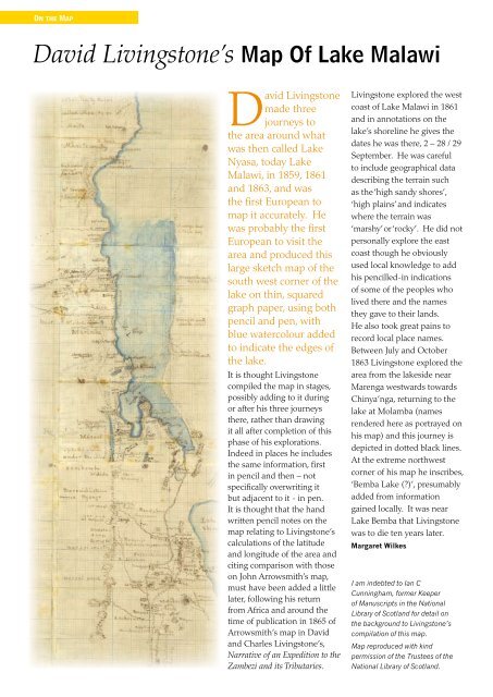
David Livingstone’s Map Of Lake Malawi<br />
David Livingstone<br />
made three<br />
journeys to<br />
the area around what<br />
was then called Lake<br />
Nyasa, today Lake<br />
Malawi, in 1859, 1861<br />
and 1863, and was<br />
the first European to<br />
map it accurately. He<br />
was probably the first<br />
European to visit the<br />
area and produced this<br />
large sketch map of the<br />
south west corner of the<br />
lake on thin, squared<br />
graph paper, using both<br />
pencil and pen, with<br />
blue watercolour added<br />
to indicate the edges of<br />
the lake.<br />
It is thought Livingstone<br />
compiled the map in stages,<br />
possibly adding to it during<br />
or after his three journeys<br />
there, rather than drawing<br />
it all after completion of this<br />
phase of his explorations.<br />
Indeed in places he includes<br />
the same information, first<br />
in pencil and then – not<br />
specifically overwriting it<br />
but adjacent to it - in pen.<br />
It is thought that the hand<br />
written pencil notes on the<br />
map relating to Livingstone’s<br />
calculations of the latitude<br />
and longitude of the area and<br />
citing comparison with those<br />
on John Arrowsmith’s map,<br />
must have been added a little<br />
later, following his return<br />
from Africa and around the<br />
time of publication in 1865 of<br />
Arrowsmith’s map in David<br />
and Charles Livingstone’s,<br />
Narrative of an Expedition to the<br />
Zambezi and its Tributaries.<br />
Livingstone explored the west<br />
coast of Lake Malawi in 1861<br />
and in annotations on the<br />
lake’s shoreline he gives the<br />
dates he was there, 2 – 28 / 29<br />
September. He was careful<br />
to include geographical data<br />
describing the terrain such<br />
as the ‘high sandy shores’,<br />
‘high plains’ and indicates<br />
where the terrain was<br />
‘marshy’ or ‘rocky’. He did not<br />
personally explore the east<br />
coast though he obviously<br />
used local knowledge to add<br />
his pencilled-in indications<br />
of some of the peoples who<br />
lived there and the names<br />
they gave to their lands.<br />
He also took great pains to<br />
record local place names.<br />
Between July and October<br />
1863 Livingstone explored the<br />
area from the lakeside near<br />
Marenga westwards towards<br />
Chinya’nga, returning to the<br />
lake at Molamba (names<br />
rendered here as portrayed on<br />
his map) and this journey is<br />
depicted in dotted black lines.<br />
At the extreme northwest<br />
corner of his map he inscribes,<br />
‘Bemba Lake (?)’, presumably<br />
added from information<br />
gained locally. It was near<br />
Lake Bemba that Livingstone<br />
was to die ten years later.<br />
Margaret Wilkes<br />
I am indebted to Ian C<br />
Cunningham, former Keeper<br />
of Manuscripts in the National<br />
Library of Scotland for detail on<br />
the background to Livingstone’s<br />
compilation of this map.<br />
Map reproduced with kind<br />
permission of the Trustees of the<br />
National Library of Scotland.