Download - Seafish
Download - Seafish
Download - Seafish

You also want an ePaper? Increase the reach of your titles
YUMPU automatically turns print PDFs into web optimized ePapers that Google loves.
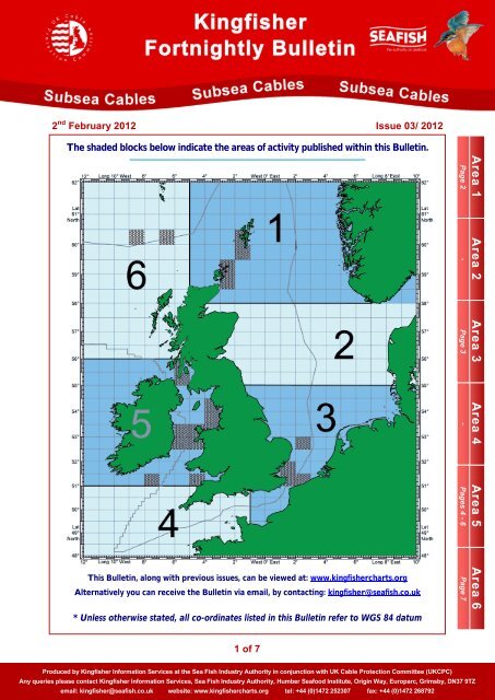
2 nd February 2012 Issue 03/ 2012<br />
The shaded blocks below indicate the areas of activity published within this Bulletin.<br />
Area 1<br />
Page 2<br />
Area 2<br />
-<br />
Area 3<br />
Page 3<br />
Area 4<br />
-<br />
Area 5<br />
Pages 4 - 6<br />
This Bulletin, along with previous issues, can be viewed at: www.kingfishercharts.org<br />
Alternatively you can receive the Bulletin via email, by contacting: kingfisher@seafish.co.uk<br />
* Unless otherwise stated, all co-ordinates listed in this Bulletin refer to WGS 84 datum<br />
Area 6<br />
Page 7<br />
1 of 7<br />
Produced by Kingfisher Information Services at the Sea Fish Industry Authority in conjunction with UK Cable Protection Committee (UKCPC)<br />
Any queries please contact Kingfisher Information Services, Sea Fish Industry Authority, Humber Seafood Institute, Origin Way, Europarc, Grimsby, DN37 9TZ<br />
email: kingfisher@seafish.co.uk website: www.kingfishercharts.org tel: +44 (0)1472 252307 fax: +44 (0)1472 268792
2 nd February 2012 Issue 03 / 2012<br />
Cable Installation – Clift Sound (Shetland) (New Entry 31-01-2012)<br />
Please be advised that Briggs Marine Contractors will be continuing works on the 11kV Power Cable in Clift Sound between<br />
Trondra and mainland Shetland. The cable was installed on 28th January; however, remaining works include dive inspection<br />
and application of cable protection.<br />
The works are being carried out along a 250m route from approximate position 60°05.847´N 01°18.983´W to approximate<br />
position 60°05.910´N 01°16.471´W. Marine operations will be running from Tuesday 31st January to Saturday 4th February<br />
2012.<br />
Operations will be carried out from both shores, and will be supported by the vessel ‘Forth Sentinel’ as a Dive Support Vessel.<br />
During operations, the Forth Sentinel will be restricted in the ability to manoeuvre. It is requested that all vessels operating<br />
within this area keep their distance and pass at minimum speed.<br />
Operations will be carried out on a daily operations basis, the vessel will display the appropriate day shapes and lights (during<br />
reduced visibility) required by the IRPCS and will actively transmit an AIS signal. A continuous watch will be maintained on VHF<br />
Channel 16 and DSC.<br />
For further information, please contact: Andrew Kinninmonth, Mobile: 07889 751 766, Email: akinninmonth@briggsmarine.co.uk<br />
Exposed Cable Sections – SHEFA-2 Segments 8 & 9 (Update 29-06-2011)<br />
Please be advised that the shore end sections of the SHEFA-2 Segment 8 cable have been surface laid for approximately 17<br />
kilometres from the Orkney landing and 26 kilometres from the Shetland landing and therefore represents a hazard to fishing<br />
and should be avoided at all times. The Orkney landing of the SHEFA-2 Segment 9 cable has also been surface laid for a<br />
distance of approximately 9 kilometres from shore. A part buried section further south along the route also exists.<br />
Please see the charts below for details of the exposed sections and for coordinates of these sections, please see Kingfisher<br />
Fortnightly Bulletin – 25 / 2009.<br />
For a copy of the Kingfisher Awareness Flyer, showing the exposed sections of SHEFA, please contact the<br />
undersigned. Alternatively, click on the link below, or visit www.kingfishercharts.org<br />
Kingfisher Awareness Flyer: SHEFA Exposed Sections (June 2011)<br />
For further information, please contact: Suni Joensen Shefa P/f, Tel: +298303605, Email: suj@ft.fo<br />
Area 1 Area 1 Area 1 Area 1 Area 1<br />
2 of 7<br />
Produced by Kingfisher Information Services at the Sea Fish Industry Authority in conjunction with UK Cable Protection Committee (UKCPC)<br />
Any queries please contact Kingfisher Information Services, Sea Fish Industry Authority, Humber Seafood Institute, Origin Way, Europarc, Grimsby, DN37 9TZ<br />
email: kingfisher@seafish.co.uk website: www.kingfishercharts.org tel: +44 (0)1472 252307 fax: +44 (0)1472 268792
2 nd February 2012 Issue 03 / 2012<br />
Cable Repair – SEA-ME-WE 3 Fibre Optic Cable (Update 23-01-2012)<br />
Please note that the cable repair of the SEA-ME-WE 3 system was completed on 20 th January 2012. The location of the repair<br />
is: 52°52.00’N 003°12.00’E<br />
For further information, please contact: John Wrottesley, Global Marine Systems, Tel: +44(0)1245 702009, email: John<br />
Wrottesley@globalmarinesystems.com<br />
Newly Installed Cable – BritNed Subsea Power Cable (New Entry 27-10-2011)<br />
As previously reported within the Kingfisher Cable Bulletin, the BritNed Subsea Power cable was installed earlier this year.<br />
The Cable System is a twin bundled High Voltage DC interconnector stretching approximately 260 km from the Isle of Grain in<br />
the UK, across to Maasvlakte in the Netherlands. The interconnector has a nominal capacity of 1000 MW, with each cable<br />
having a diameter of 119 mm. The cable installation was completed in June 2011 with the majority of cable being lowered to in<br />
excess of 1.5 metres.<br />
For a copy of the Kingfisher Awareness Flyer for the BritNed Subsea Power Cable, please contact the undersigned.<br />
Alternatively, click on the link below, or visit www.kingfishercharts.org<br />
Kingfisher Awareness Flyer: BritNed Subsea Power Cable<br />
For further information, please contact: BritNed Control Room, Tel: +44 (0)1634 273080 or +44 (0)800 0481569.<br />
Hazardous Condition of Cable – Ulysses South landing - St Margaret's Bay<br />
Further to earlier Notices, the Ulysses South submarine cable landing at St Margaret's Bay, near Dover, remains broken at a<br />
position:<br />
51°08.70'N 01° 24.06'E<br />
This position lies approximately 1.3km offshore<br />
in a water depth of 15 metres. As a result of this<br />
fault, the cable at the approaches to St<br />
Margaret's Bay has been dragged an<br />
indeterminate distance to the north of its as laid<br />
route on either side of the fault position. Caution<br />
should therefore be exercised in this area until<br />
the cable repair operation has been carried out.<br />
For further information, please contact: Tom Manning, Tel: +44 (0)7795 445192, Email: tom.manning@globalmarinesystems.com<br />
Area 3 Area 3 Area 3 Area 3 Area 3<br />
3 of 7<br />
Produced by Kingfisher Information Services at the Sea Fish Industry Authority in conjunction with UK Cable Protection Committee (UKCPC)<br />
Any queries please contact Kingfisher Information Services, Sea Fish Industry Authority, Humber Seafood Institute, Origin Way, Europarc, Grimsby, DN37 9TZ<br />
email: kingfisher@seafish.co.uk website: www.kingfishercharts.org tel: +44 (0)1472 252307 fax: +44 (0)1472 268792
2 nd February 2012 Issue 03 / 2012<br />
Marine Cable Works – East West Interconnector Cable (Update 18-01-2012)<br />
Survey<br />
Fishermen are advised of marine survey operations that are currently scheduled to commence on or around 16 th January 2012 in the<br />
waters off Rush Beach, County Dublin between reference location KP8.0 (53°33.32’N 005°58.12’W) and east across the southern Irish<br />
Sea to reference location KP115 (53°34.54’N 004°57.97’W) approximately 10nm north of Amlwch, Anglesey, North Wales coast.<br />
Survey vessel BIBBY TETHRA has been assigned to carry out this pre-installation geophysical survey along the deep water section of<br />
the planned EirGrid East West Interconnector cable route. The survey vessel will be operating on a 24-hour basis and vessel will be<br />
transmitting an AIS signal. A listening watch will be maintained on VHF Ch16 and vessel mobile number is 07920 075745.<br />
Fishermen are advised not to leave any static fishing equipment within a distance of 1000 metres of the route and are respectfully<br />
asked to withdraw and keep beyond a distance of at least 1 nautical mile from the survey vessel that will be operating with towed<br />
equipment and will be restricted in its ability to manoeuvre.<br />
North Wales Coast<br />
Fishermen are advised that cable burial operations along the route of the EirGrid East West Interconnector power cable off<br />
Barkby Beach, Rhyl and west in the waters off north Wales are due to commence on 19 th January 2012. MV ROLLINGSTONE<br />
will be involved in cable protection rock placement operations along the EirGrid EWIC cable off Barkby Beach and at specific<br />
exposed cable crossing locations in the waters off North Wales.<br />
Trawler skippers are advised that sections of the EirGrid EWIC power cable will remain unburied until cable burial operations<br />
have been completed, however, guard vessels will continue to be stationed in the vicinity of exposed cable sections.<br />
Fishermen are advised not to leave any static fishing equipment within a distance of 500 metres of the EirGrid EWIC cable<br />
route. All Skippers are respectfully asked to withdraw and keep beyond a distance of at least 1 nautical mile from the newly<br />
installed cable and all cable vessels associated with these marine operations.<br />
Rush - North Dublin<br />
Please be advised that shore end marine cable installation works in the waters off Rush North Beach, North County Dublin are<br />
due to commence on or around 19 th January 2012. MV ROLLINGSTONE will be involved in cable protection rock placement<br />
operations along the EirGrid EWIC cable off Rush Beach at specific exposed cable locations.<br />
Fishermen are advised that there is exposed cable from position 53°32.326’N 005°58.123’W (Ref KP8) and west into Rush<br />
North Beach and are advised not to leave any static fishing equipment within a distance of 500 metres of the EirGrid EWIC<br />
cable route. All Skippers are respectfully asked to withdraw and keep beyond a distance of at least 1 nautical mile from all cable<br />
vessels associated with these marine operations.<br />
Route Position List:<br />
1. 53°31.440'N 06°05.077'W Ireland<br />
2. 53°31.442'N 06°05.068'W<br />
3. 53°31.590'N 06°04.940'W<br />
4. 53°32.181'N 06°02.107'W<br />
5. 53°32.999'N 05°53.304'W<br />
6. 53°36.193'N 05°20.639'W<br />
7. 53°36.129'N 05°20.107'W<br />
8. 53°36.149'N 05°19.728'W<br />
9. 53°36.160'N 05°19.045'W<br />
10. 53°36.103'N 05°18.510'W<br />
11. 53°36.178'N 05°17.979'W<br />
12. 53°36.246'N 05°13.944'W<br />
13. 53°36.029'N 05°12.670'W<br />
14. 53°36.015'N 05°11.754'W<br />
15. 53°35.951'N 05°11.153'W<br />
16. 53°36.225'N 05°10.197'W<br />
17. 53°36.192'N 05°07.039'W<br />
18. 53°35.936'N 05°06.161'W<br />
19. 53°36.168'N 05°05.303'W<br />
20. 53°36.132'N 05°04.494'W<br />
21. 53°35.997'N 05°04.087'W<br />
22. 53°36.078'N 04°59.986'W<br />
23. 53°36.032'N 04°57.392'W<br />
24. 53°36.161'N 04°56.448'W<br />
25. 53°35.938'N 04°56.054'W<br />
26. 53°35.999'N 04°55.580'W<br />
27. 53°35.901'N 04°50.299'W<br />
28. 53°36.330'N 04°48.949'W<br />
29. 53°36.109'N 04°48.015'W<br />
30. 53°36.260'N 04°46.248'W<br />
31. 53°35.691'N 04°43.000'W<br />
32. 53°36.003'N 04°39.320'W<br />
33. 53°35.838'N 04°38.087'W<br />
34. 53°35.812'N 04°31.169'W<br />
35. 53°35.549'N 04°25.497'W<br />
36. 53°35.209'N 04°23.745'W<br />
37. 53°34.904'N 04°19.966'W<br />
38. 53°31.689'N 04°11.107'W<br />
39. 53°28.465'N 04°00.671'W<br />
40. 53°26.862'N 03°53.663'W<br />
41. 53°26.561'N 03°51.589'W<br />
42. 53°24.118'N 03°39.814'W<br />
43. 53°23.479'N 03°36.476'W<br />
44. 53°23.392'N 03°35.190'W<br />
45. 53°23.194'N 03°34.755'W<br />
46. 53°22.849'N 03°34.349'W<br />
47. 53°22.067'N 03°32.901'W<br />
48. 53°21.474'N 03°31.653'W<br />
49. 53°21.351'N 03°29.475'W<br />
50. 53°21.275'N 03°28.964'W<br />
51. 53°20.998'N 03°24.423'W<br />
52. 53°20.651'N 03°24.093'W Wales<br />
For further information, please contact: Colin Richards, Tel: +44 (0)1404 46323, Mobile: +44 (0)7702 693 660, Email:<br />
colinrichards@networkmarine.fsnet.co.uk<br />
Cable Installation/Burial Works – Celtix Connect Cable (Update 13-12-2011)<br />
Unfortunately the outline plan as below has been delayed due to the recent weather. The CS Innovator has just departed Dublin<br />
and is on her way to the Welsh side of the works area to begin cable recovery of the existing cable. The outline plan of work,<br />
which has slipped slightly, is as follows:<br />
• 10th December - Depart Dublin Port<br />
• 11th December – Conduct pre-lay grapnel run<br />
• 22 nd December – Begin cable installation<br />
• 30th December – Land cable at Welsh shore end location<br />
• 9th January – Complete Post lay inspection & burial<br />
• 15th January – Demobilise<br />
Continued over page…<br />
Area 5 Area 5 Area 5 Area 5 Area 5<br />
4 of 7<br />
Produced by Kingfisher Information Services at the Sea Fish Industry Authority in conjunction with UK Cable Protection Committee (UKCPC)<br />
Any queries please contact Kingfisher Information Services, Sea Fish Industry Authority, Humber Seafood Institute, Origin Way, Europarc, Grimsby, DN37 9TZ<br />
email: kingfisher@seafish.co.uk website: www.kingfishercharts.org tel: +44 (0)1472 252307 fax: +44 (0)1472 268792
2 nd February 2012 Issue 03 / 2012<br />
…continued from previous page<br />
Route Position List:<br />
1. 53°21.386'N 006°02.519'W<br />
2. 53°21.810'N 006°01.795'W<br />
3. 53°22.748'N 006°00.571'W<br />
4. 53°29.590'N 005°50.742'W<br />
5. 53°29.767'N 005°50.334'W<br />
6. 53°29.921'N 005°49.724'W<br />
7. 53°29.989'N 005°49.169'W<br />
8. 53°30.298'N 005°47.075'W<br />
9. 53°30.361'N 005°46.171'W<br />
10. 53°30.491'N 005°45.290'W<br />
11. 53°30.685'N 005°44.441'W<br />
12. 53°32.202'N 005°34.068'W<br />
13. 53°32.214'N 005°33.713'W<br />
14. 53°31.442'N 005°24.899'W<br />
15. 53°30.390'N 005°14.885'W<br />
16. 53°30.324'N 005°14.559'W<br />
17. 53°29.933'N 005°10.714'W<br />
18. 53°29.878'N 005°10.455'W<br />
19. 53°29.788'N 005°10.226'W<br />
20. 53°29.112'N 005°08.921'W<br />
21. 53°28.916'N 005°08.604'W<br />
22. 53°28.753'N 005°08.404'W<br />
23. 53°28.533'N 005°08.216'W<br />
24. 53°27.870'N 005°07.857'W<br />
25. 53°26.828'N 005°06.965'W<br />
26. 53°26.203'N 005°06.629'W<br />
27. 53°26.001'N 005°06.497'W<br />
28. 53°25.672'N 005°06.234'W<br />
29. 53°25.258'N 005°05.675'W<br />
30. 53°24.712'N 005°04.707'W<br />
31. 53°23.638'N 005°03.257'W<br />
32. 53°21.315'N 005°01.574'W<br />
33. 53°21.063'N 005°01.466'W<br />
34. 53°20.862'N 005°01.327'W<br />
35. 53°20.225'N 005°00.686'W<br />
36. 53°20.056'N 005°00.430'W<br />
37. 53°16.622'N 004°52.771'W<br />
38. 53°16.439'N 004°52.439'W<br />
39. 53°15.387'N 004°50.100'W<br />
40. 53°15.247'N 004°49.714'W<br />
41. 53°14.987'N 004°48.297'W<br />
42. 53°14.753'N 004°45.834'W<br />
43. 53°14.746'N 004°45.348'W<br />
44. 53°14.679'N 004°44.639'W<br />
45. 53°14.613'N 004°44.178'W<br />
46. 53°14.577'N 004°43.315'W<br />
47. 53°14.731'N 004°42.255'W<br />
48. 53°14.877'N 004°41.777'W<br />
49. 53°15.151'N 004°41.243'W<br />
50. 53°15.313'N 004°41.019'W<br />
51. 53°16.194'N 004°40.214'W<br />
52. 53°16.750'N 004°39.623'W<br />
53. 53°17.269'N 004°39.033'W<br />
For further information, please contact: Tom Manning, Tel: +44 (0)7795 445192, Email: tom.manning@globalmarinesystems.com<br />
Repair of Power Cables - Moyle Interconnector (North Channel) (New Entry 10-11-2011)<br />
Repair is underway on faults on both the northern and southern power trasnmission cables associated with the Moyle<br />
Interconnect. The power cables lie in the North Channel between Islandmagee, Northern Ireland and Currarie Port, south of<br />
Ballantrae, Ayrshire, Scotland.<br />
Cable repair activities will take place between the following co-ordinates in the North Channel of the Irish Sea.<br />
North Cable Fault Window 55° 03.816 ‘N 005° 05.572 ‘W to 55° 03.783 N 005° 06.112 ‘W<br />
South Cabel Fault Window 54° 55.082 ‘N 005° 30.667 ‘W to 54° 54.173 N 005° 33.367 ‘W<br />
The execution plan commenced in late October and could last 12 weeks. The program is subject to both technical and weather<br />
delays.<br />
Fishing vessels are advised that sections of the Moyle Interconnector power cables may be unburied at times during this work.<br />
Skippers are requested to keep beyond a distance of at least 1 nautical mile from the advised cable sections. Vessels are also<br />
requested to keep beyond 1 nautical mile from the cable repair vessel North Sea Giant as operations limit the manoeuvrability of<br />
the repair vessel and include the use of ROVs.<br />
For further information, please contact: Maurice Smith, Moyle Interconnector, Tel: +44(0)28 9095 8115, email:<br />
Maurice.smith@powerteam.eu.com<br />
Shallow Burial of Submarine Cable Section – Hibernia ‘D’ (New Entry 25-11-2010)<br />
Following a recent repair to the Hibernia ‘D’ cable, there was difficulty in reburying the cable to the required depth of 1 metre.<br />
Please note the section below which could only be buried to a depth of 30cm, this section also contains the repaired splice.<br />
Please exercise caution in this area.<br />
Shallow Buried Section<br />
1. 51°18.893'N 007°50.289'W<br />
2. 51°18.903'N 007°50.229'W<br />
3. 51°18.997'N 007°50.127'W<br />
4. 51°18.998'N 007°50.120'W<br />
5. 51°18.927'N 007°50.011'W<br />
6. 51°18.951'N 007°49.641'W<br />
7. 51°18.974'N 007°49.336'W<br />
Area 5 Area 5 Area 5 Area 5 Area 5<br />
For further information, please contact: Tom Manning, Tel: +44 (0)7795 445192, Email: tom.manning@globalmarinesystems.com<br />
5 of 7<br />
Produced by Kingfisher Information Services at the Sea Fish Industry Authority in conjunction with UK Cable Protection Committee (UKCPC)<br />
Any queries please contact Kingfisher Information Services, Sea Fish Industry Authority, Humber Seafood Institute, Origin Way, Europarc, Grimsby, DN37 9TZ<br />
email: kingfisher@seafish.co.uk website: www.kingfishercharts.org tel: +44 (0)1472 252307 fax: +44 (0)1472 268792
2 nd February 2012 Issue 03 / 2012<br />
Exposed Submarine Cable Section – Hibernia ‘D’<br />
Please note that the Hibernia ‘D’ cable has been surveyed and has an exposed section. This is indicated in the map below.<br />
The exposed section runs from:<br />
52° 59.433' N 05° 39.540' W to<br />
52° 45.118' N 05° 41.797' W<br />
For full details of the exposed cable<br />
route, please refer to Kingfisher<br />
Fortnightly Bulletin Issue 24 / 2006.<br />
For further information, please contact: Tom Manning, Tel: +44 (0)7795 445192, Email: tom.manning@globalmarinesystems.com<br />
Repair to Lanis Cable – UK – IOM (Off Port Grenaugh)<br />
The LANIS 1 cable was damaged approximately 600m off Port Grenaugh beach in November 2006. The fault was repaired by<br />
laying a new shore end section and unfortunately it was not possible to bury the cable at the bight area or the cable shoreward.<br />
All fishing vessels are advised to keep clear of the area below and route below:<br />
1. 54˚ 05.609’N 04˚ 33.599’W<br />
2. 54˚ 05.678’N 04˚ 33.666’W<br />
3. 54˚ 05 683’N 04˚ 33.669’W<br />
4. 54˚ 05 683’N 04˚ 33.681’W<br />
5. 54˚ 05 678’N 04˚ 33.683’W<br />
6. 54˚ 05.655’N 04˚ 33.691’W<br />
7. 54˚ 05.652’N 04˚ 33.818’W<br />
8. 54˚ 05.866’N 04˚ 34.181’W<br />
9. 54˚ 05.912’N 04˚ 34.258’W<br />
10. 54˚ 06.102’N 04˚ 34.595’W<br />
11. 54˚ 06.158’N 04˚ 34.670’W<br />
For further information, please contact: Jon Ford, Cable & Wireless UK, Waterside House, Longshot Lane, Bracknell, Berkshire,<br />
RG12 1XL, Tel: +44 (0)1344 713784, Mob: +44 (0) 7776 165571, Email: Jon.Ford@cw.com<br />
Repair to SOLAS Cable – UK to Ireland<br />
The SOLAS cable has been repaired due to a fault at the following position: 51°24.634’N 04°55.272’W. Burial was attempted,<br />
though the cable remains at risk of snagging with fishing gear as only shallow burial was achieved.<br />
For further information, please contact: Jon Ford, Cable & Wireless UK, Waterside House, Longshot Lane, Bracknell, Berkshire,<br />
RG12 1XL, Tel: +44 (0)1344 713784, Mob: +44 (0) 7776 165571, Email: Jon.Ford@cw.com<br />
Area 5 Area 5 Area 5 Area 5 Area 5<br />
6 of 7<br />
Produced by Kingfisher Information Services at the Sea Fish Industry Authority in conjunction with UK Cable Protection Committee (UKCPC)<br />
Any queries please contact Kingfisher Information Services, Sea Fish Industry Authority, Humber Seafood Institute, Origin Way, Europarc, Grimsby, DN37 9TZ<br />
email: kingfisher@seafish.co.uk website: www.kingfishercharts.org tel: +44 (0)1472 252307 fax: +44 (0)1472 268792
2 nd February 2012 Issue 03 / 2012<br />
Cable Repair – TAT 14 (Segment K) (New Entry 12-07-2011)<br />
There has been a recent repair on the TAT 14 segment K cable north of the Butt of Lewis. Post repair burial was carried out but<br />
due to the adverse seabed conditions some sections of cable remain exposed between positions:<br />
East extremity: 60°01.085’N 006°30.375’W<br />
West extremity: 60°01.193’N 006°33.816’W<br />
Between these two positions there is a revised repeater position at 60°01.147’N 006°31.195’W, and the crown of the final splice<br />
bight lies to the south of the cable line at position 60°00.889’N 006°33.435’W.<br />
For further information, please contact: Barry Peck, Sealine Marine Services, Email: bepeck@sealine.org.uk<br />
Cable Repairs – TAT 14 (Segment K) (Update 12-04-2011)<br />
There have been two recent repairs on the TAT 14 segment K cable north west of the Butt of Lewis on the Wyville Thompson<br />
Ridge. Due to the adverse seabed conditions it has not been possible to bury the repaired sections, and there are two areas<br />
that are a danger to fishing gear. These are:<br />
Point A<br />
Point B<br />
Point C<br />
Point D<br />
Point A’<br />
Point B’<br />
Point C’<br />
Point D’<br />
Repair 27 A<br />
60° 14.00’N 008° 36.00’W<br />
60° 14.00’N 008° 30.00’W<br />
60° 13.00’N 008° 30.00’W<br />
60° 13.00’N 008° 36.00’W<br />
Repair 27 B<br />
60° 13.400’N 008° 08.000’W<br />
60° 13.400’N 008° 03.500’W<br />
60° 12.500’N 008° 03.500’W<br />
60° 12.500’N 008° 08.000’W<br />
Both these areas contain a length of unburied cable and a final splice bight with the slip ropes still attached. Fishermen are<br />
requested to avoid fishing in the vicinity of both these areas.<br />
For a copy of the Kingfisher Awareness Flyers for the Sprint 2011 (TAT 14 Segment K) cable, please contact the<br />
undersigned. Alternatively, click on the link below, or visit www.kingfishercharts.org<br />
Kingfisher Awareness Flyer: Sprint 2011 (TAT 14 Segment K) - ENGLISH<br />
Kingfisher Awareness Flyer: Sprint 2011 (TAT 14 Segment K) – FRENCH<br />
Kingfisher Awareness Flyer: Sprint 2011 (TAT 14 Segment K) - FAROESE<br />
For further information, please contact: Barry Peck, Sealine Marine Services, Email: bepeck@sealine.org.uk<br />
Area 6 Area 6 Area 6 Area 6 Area 6<br />
7 of 7<br />
Produced by Kingfisher Information Services at the Sea Fish Industry Authority in conjunction with UK Cable Protection Committee (UKCPC)<br />
Any queries please contact Kingfisher Information Services, Sea Fish Industry Authority, Humber Seafood Institute, Origin Way, Europarc, Grimsby, DN37 9TZ<br />
email: kingfisher@seafish.co.uk website: www.kingfishercharts.org tel: +44 (0)1472 252307 fax: +44 (0)1472 268792