KESTREL EYE - Space and Missile Defense Command - U.S. Army
KESTREL EYE - Space and Missile Defense Command - U.S. Army
KESTREL EYE - Space and Missile Defense Command - U.S. Army

Create successful ePaper yourself
Turn your PDF publications into a flip-book with our unique Google optimized e-Paper software.
USASMDC/ARSTRAT<br />
Technical Center<br />
<strong>KESTREL</strong> <strong>EYE</strong><br />
Kestrel Eye Visible Imagery Nanosatellite Technology Demonstration<br />
Summary<br />
• Nanosatellite technology demonstrator<br />
weighing about 10 kilograms<br />
• Electro-optical imaging satellite with<br />
1.5-meter ground resolution<br />
• Low cost: $1M per spacecraft in<br />
production mode<br />
• Operational life of greater than one year<br />
in Low Earth Orbit<br />
• Tactically responsive: Ability to task <strong>and</strong><br />
receive data from the satellite during the<br />
same pass overhead<br />
• As revolutionary as moving from the “film<br />
bucket return” era to digital transmission:<br />
persistent availability down to the<br />
individual Soldier<br />
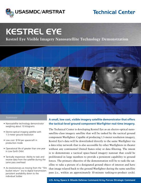
A small, low cost, visible imagery satellite demonstrator that offers<br />
the tactical-level ground component Warfighter real-time imagery.<br />
The Technical Center is developing Kestrel Eye as an electro-optical nanosatellite-class<br />
imagery satellite that will be tasked by the tactical ground<br />
component Warfighter. Capable of producing 1.5-meter resolution imagery,<br />
Kestrel Eye’s data will be downlinked directly to the same Warfighter via<br />
a data relay network that is also accessible by other Warfighters in theater<br />
without any continental United States relay or data filtering. The intent<br />
is to demonstrate a tactical space-based imagery nanosat that could be<br />
proliferated in large numbers to provide a persistent capability to ground<br />
forces. The primary objective of the demonstration will be to task the satellite<br />
to take a picture of a designated ground object of interest <strong>and</strong> have<br />
that image relayed back to the ground Warfighter during the same satellite<br />
pass (i.e., within an approximately 10-minute tasking-to-product cycle).<br />
U.S. <strong>Army</strong> <strong>Space</strong> & <strong>Missile</strong> <strong>Defense</strong> Comm<strong>and</strong>/<strong>Army</strong> Forces Strategic Comm<strong>and</strong>
Technical Center<br />
<strong>KESTREL</strong> <strong>EYE</strong><br />
Kestrel Eye Visible Imagery Nanosatellite Technology Demonstration<br />
2. The operator loads objects/areas of interest by designating<br />
them with mouse clicks. The positions can be<br />
adjusted by dragging <strong>and</strong> dropping. The approximate<br />
photo footprints are shown by white rectangles.<br />
3. The object track (red) is automatically updated as objects/areas<br />
of interest are added. If an object/area of<br />
interest is beyond the maneuvering capability of the<br />
spacecraft, then the operator is warned by a pop-up<br />
display.<br />
4. When satisfied, the operator clicks on "Send to <strong>Space</strong>craft"<br />
<strong>and</strong> the requested trajectory is transmitted.<br />
The Kestrel Eye program will extend the Unmanned<br />
Aerial Vehicle paradigm into space: a dramatically lower<br />
unit cost <strong>and</strong> proliferated numbers of satellites enabling the<br />
system to be dedicated to <strong>and</strong> operated by Warfighters who<br />
receive only parceled-out service today from more powerful,<br />
expensive <strong>and</strong> far less numerous assets. The eventual goal is<br />
persistent coverage available to every Soldier on a h<strong>and</strong>held<br />
device – as GPS is today. The CONOPS for this experiment<br />
involves very small satellites, laptops <strong>and</strong> S-B<strong>and</strong> receiver<br />
antennae.<br />
5. Kestrel Eye executes the planned track <strong>and</strong> snaps pictures<br />
at the designated times.<br />
6. Kestrel Eye immediately downlinks the requested images<br />
to a data relay network accessible by the Warfighter<br />
who tasked the satellite as well as any other Warfighter<br />
on the network who needs it.<br />
Kestrel Eye advantages include:<br />
• Higher altitude than UAVs: coverage above denied areas<br />
<strong>and</strong> invulnerable to surface-to-air missile threats<br />
• Smaller size <strong>and</strong> greater number: affordable, persistent<br />
presence, lower probability of detection, less vulnerable<br />
to anti-satellite weapons<br />
• Graceful degradation: no single shot, launch failure or<br />
anomaly causes complete loss of service<br />
Operational Concept for the Kestrel Eye Field Portable<br />
Ground Station:<br />
1. The operator clicks on any point of the ground trace<br />
displayed on the world map <strong>and</strong> calls up the enlarged<br />
local map.<br />
www.army.mil/smdc<br />
For more information, please contact:<br />
USASMDC/ARSTRAT/Public Affairs Office<br />
P.O. Box 1500<br />
Huntsville, AL 35807<br />
Phone: 256-955-3887<br />
Fax: 256-955-1214<br />
Email: webmaster@smdc.army.mil<br />
www.facebook.com/armysmdc<br />
www.twitter.com/armysmdc<br />
www.flickr.com/armysmdc<br />
www.youtube.com/armysmdc<br />
Distribution A : 9363 0112/0186