Niemi et al. - Department of Earth and Planetary Sciences
Niemi et al. - Department of Earth and Planetary Sciences
Niemi et al. - Department of Earth and Planetary Sciences

You also want an ePaper? Increase the reach of your titles
YUMPU automatically turns print PDFs into web optimized ePapers that Google loves.
Downloaded from gsabull<strong>et</strong>in.gsapubs.org on March 22, 2010<br />
Geologic<strong>al</strong> Soci<strong>et</strong>y <strong>of</strong> America Bull<strong>et</strong>in<br />
Distribution <strong>and</strong> provenance <strong>of</strong> the middle Miocene Eagle Mountain Formation,<br />
<strong>and</strong> implications for region<strong>al</strong> kinematic an<strong>al</strong>ysis <strong>of</strong> the Basin <strong>and</strong> Range province<br />
Nathan A. <strong>Niemi</strong>, Brian P. Wernicke, Robert J. Brady, Jason B. S<strong>al</strong>eeby <strong>and</strong> George C. Dunne<br />
Geologic<strong>al</strong> Soci<strong>et</strong>y <strong>of</strong> America Bull<strong>et</strong>in 2001;113;419-442<br />
doi: 10.1130/0016-7606(2001)1132.0.CO;2<br />
Email <strong>al</strong>erting services<br />
Subscribe<br />
click www.gsapubs.org/cgi/<strong>al</strong>erts to receive free e-mail <strong>al</strong>erts when new articles<br />
cite this article<br />
click www.gsapubs.org/subscriptions/ to subscribe to Geologic<strong>al</strong> Soci<strong>et</strong>y <strong>of</strong><br />
America Bull<strong>et</strong>in<br />
Permission request click http://www.geosoci<strong>et</strong>y.org/pubs/copyrt.htm#gsa to contact GSA<br />
Copyright not claimed on content prepared wholly by U.S. government employees within scope <strong>of</strong> their<br />
employment. Individu<strong>al</strong> scientists are hereby granted permission, without fees or further requests to GSA,<br />
to use a single figure, a single table, <strong>and</strong>/or a brief paragraph <strong>of</strong> text in subsequent works <strong>and</strong> to make<br />
unlimited copies <strong>of</strong> items in GSA's journ<strong>al</strong>s for noncommerci<strong>al</strong> use in classrooms to further education <strong>and</strong><br />
science. This file may not be posted to any Web site, but authors may post the abstracts only <strong>of</strong> their<br />
articles on their own or their organization's Web site providing the posting includes a reference to the<br />
article's full citation. GSA provides this <strong>and</strong> other forums for the presentation <strong>of</strong> diverse opinions <strong>and</strong><br />
positions by scientists worldwide, regardless <strong>of</strong> their race, citizenship, gender, religion, or politic<strong>al</strong><br />
viewpoint. Opinions presented in this publication do not reflect <strong>of</strong>fici<strong>al</strong> positions <strong>of</strong> the Soci<strong>et</strong>y.<br />
Notes<br />
Geologic<strong>al</strong> Soci<strong>et</strong>y <strong>of</strong> America
Downloaded from gsabull<strong>et</strong>in.gsapubs.org on March 22, 2010<br />
Distribution <strong>and</strong> provenance <strong>of</strong> the middle Miocene Eagle Mountain<br />
Formation, <strong>and</strong> implications for region<strong>al</strong> kinematic an<strong>al</strong>ysis <strong>of</strong> the<br />
Basin <strong>and</strong> Range province<br />
Nathan A. <strong>Niemi</strong>*<br />
Brian P. Wernicke<br />
Robert J. Brady<br />
Jason B. S<strong>al</strong>eeby<br />
Division <strong>of</strong> Geologic<strong>al</strong> <strong>and</strong> Plan<strong>et</strong>ary <strong>Sciences</strong>, C<strong>al</strong>ifornia Institute <strong>of</strong> Technology, 1200 East C<strong>al</strong>ifornia Boulevard, Pasadena,<br />
C<strong>al</strong>ifornia 91125, USA<br />
George C. Dunne<br />
<strong>Department</strong> <strong>of</strong> Geologic<strong>al</strong> <strong>Sciences</strong>, C<strong>al</strong>ifornia State University, 18111 Nordh<strong>of</strong>f Stre<strong>et</strong>, Northridge, C<strong>al</strong>ifornia 91330, USA<br />
ABSTRACT<br />
Conglomeratic strata from middle Miocene<br />
sections in the centr<strong>al</strong> Resting Spring<br />
Range <strong>and</strong> nearby Eagle Mountain, C<strong>al</strong>ifornia,<br />
contain a clast assemblage including<br />
marble, orthoquartzite, fusulinid grainstone,<br />
<strong>and</strong> coarse (1 m) monzogabbro, interstratified<br />
with tephras yielding laser-fusion<br />
40 Ar/ 39 Ar ages <strong>of</strong> 11.6, 13.4, <strong>and</strong> 15.0<br />
Ma. P<strong>et</strong>rographic <strong>and</strong> geochronologic evidence<br />
ties the clast assemblage to a source<br />
area in the southern Cottonwood Mountains,<br />
C<strong>al</strong>ifornia, 100 km west-northwest<br />
<strong>of</strong> their present location. In the upper 100<br />
m <strong>of</strong> the Resting Spring Range section, conglomerates<br />
are derived <strong>al</strong>most exclusively<br />
from the southern Cottonwoods source, <strong>and</strong><br />
s<strong>and</strong>stone modes are as much as 50% angular<br />
plagioclase derived from the monzogabbro.<br />
The lack <strong>of</strong> dilution <strong>of</strong> this d<strong>et</strong>ritus<br />
by other sources <strong>and</strong> sedimentary features<br />
in both sections indicate (1) that deposition<br />
occurred on an <strong>al</strong>luvi<strong>al</strong> fan with a northnortheast<br />
p<strong>al</strong>eoslope <strong>and</strong> (2) that transport<br />
<strong>of</strong> the gravels by sedimentary processes was<br />
probably 20 km north-northeast, in a direction<br />
norm<strong>al</strong> to the present azimuth to<br />
their source. Therefore, we interpr<strong>et</strong> most<br />
or <strong>al</strong>l <strong>of</strong> the n<strong>et</strong> east-southeast transport as<br />
a result <strong>of</strong> extension<strong>al</strong> <strong>and</strong> strike-slip faulting<br />
b<strong>et</strong>ween the Cottonwood Mountains<br />
<strong>and</strong> the Resting Spring Range since 11–12<br />
*E-mail: niemi@gps.c<strong>al</strong>tech.edu.<br />
Ma. Restoration <strong>of</strong> these deposits to a position<br />
10–20 km north-northeast <strong>of</strong> the eastern<br />
margin <strong>of</strong> the monzogabbro source<br />
(east margin <strong>of</strong> the Hunter Mountain batholith)<br />
yields a n<strong>et</strong> tectonic displacement <strong>of</strong><br />
the Cottonwood Mountains relative to the<br />
Resting Spring Range <strong>of</strong> 104 km N67W.<br />
This result confirms previous reconstructions<br />
based on the restoration <strong>of</strong> isopachs<br />
in the Cordilleran miogeocline, pre-Cenozoic<br />
structur<strong>al</strong> features, <strong>and</strong> other proxim<strong>al</strong><br />
Tertiary deposits in the region.<br />
Keywords: clastic rocks, Death V<strong>al</strong>ley, extension,<br />
Miocene, provenance, sedimentary<br />
basins.<br />
INTRODUCTION<br />
Evolving debate over the magnitude, style,<br />
<strong>and</strong> timing <strong>of</strong> Cenozoic extension<strong>al</strong> tectonics<br />
in the Basin <strong>and</strong> Range province centers on<br />
the identification, correlation, <strong>and</strong> reconstruction<br />
<strong>of</strong> preextension<strong>al</strong> markers, such as isopachs,<br />
facies trends, thrust faults, <strong>and</strong> p<strong>al</strong>eoisotherm<strong>al</strong><br />
surfaces (e.g., Snow, 1992). The<br />
extreme extension suggested by many <strong>of</strong> these<br />
reconstructions is a starting assumption for<br />
physic<strong>al</strong> models bearing on the bulk constitutive<br />
properties <strong>of</strong> the deep continent<strong>al</strong> crust<br />
(e.g., Kruse <strong>et</strong> <strong>al</strong>., 1991; Wdowinski <strong>and</strong><br />
Axen, 1992). In addition, a large fraction <strong>of</strong><br />
PacificNorth America plate motion is absorbed<br />
within the Basin <strong>and</strong> Range, <strong>and</strong> therefore<br />
region<strong>al</strong> kinematic an<strong>al</strong>ysis is fundament<strong>al</strong><br />
to the problem <strong>of</strong> how plate motion<br />
influences continent<strong>al</strong> deformation (e.g., Atwater<br />
<strong>and</strong> Stock, 1998; Wernicke <strong>and</strong> Snow,<br />
1998). This type <strong>of</strong> an<strong>al</strong>ysis is particularly<br />
germane to the centr<strong>al</strong> Basin <strong>and</strong> Range (near<br />
the latitude <strong>of</strong> Las Vegas; Wernicke, 1992),<br />
where d<strong>et</strong>ermination <strong>of</strong> the Neogene motion<br />
<strong>of</strong> the SierranGreat V<strong>al</strong>ley subplate relative<br />
to the Colorado Plateau is possible via reconstruction<br />
<strong>of</strong> a we<strong>al</strong>th <strong>of</strong> stratigraphic <strong>and</strong> structur<strong>al</strong><br />
markers spanning the entire province<br />
(Wernicke <strong>et</strong> <strong>al</strong>., 1988; Dickinson <strong>and</strong> Wernicke,<br />
1997).<br />
One reconstruction <strong>of</strong> such an array <strong>of</strong> region<strong>al</strong><br />
markers in the centr<strong>al</strong> Basin <strong>and</strong> Range<br />
suggests 250 km <strong>of</strong> west-northwest motion <strong>of</strong><br />
the southern Sierra Nevada relative to the Colorado<br />
Plateau since ca. 16 Ma (Wernicke <strong>et</strong><br />
<strong>al</strong>., 1988; Snow, 1992). The largest proposed<br />
<strong>of</strong>fs<strong>et</strong> <strong>of</strong> a specific geologic feature in that reconstruction,<br />
<strong>and</strong> to our knowledge, anywhere<br />
in the Basin <strong>and</strong> Range, is based on the correlation<br />
<strong>of</strong> the Panamint thrust at Tucki Mountain<br />
with the Chicago Pass thrust in the NopahResting<br />
Spring Range area, indicating<br />
about 92 km <strong>of</strong> west-northwest separation <strong>of</strong><br />
the two ranges (Fig. 1). The PanamintChicago<br />
Pass correlation (Wernicke <strong>et</strong><br />
<strong>al</strong>., 1988, 1993) was initi<strong>al</strong>ly implied by Stewart’s<br />
(1983) reconstruction <strong>of</strong> isopachs <strong>and</strong> facies<br />
trends <strong>of</strong> pre-Mesozoic formations in the<br />
region, which closely juxtaposed Tucki Mountain<br />
<strong>and</strong> the Resting Spring Range. This reconstruction<br />
was later supported by correlations<br />
<strong>of</strong> a suite <strong>of</strong> three contractile structures<br />
GSA Bull<strong>et</strong>in; April 2001; v. 113; no. 4; p. 419–442; 15 figures; 5 tables; Data Repository item 2001031.<br />
For permission to copy, contact Copyright Clearance Center at www.copyright.com<br />
2001 Geologic<strong>al</strong> Soci<strong>et</strong>y <strong>of</strong> America 419
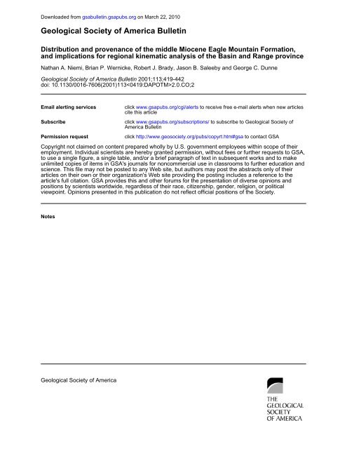
Downloaded from gsabull<strong>et</strong>in.gsapubs.org on March 22, 2010<br />
NIEMI <strong>et</strong> <strong>al</strong>.<br />
Figure 1. Map showing major ranges <strong>and</strong> basins in the Death V<strong>al</strong>ley region, C<strong>al</strong>ifornia<br />
<strong>and</strong> Nevada, the distribution <strong>of</strong> thrust faults <strong>and</strong> folds <strong>of</strong>fs<strong>et</strong> <strong>al</strong>ong Cenozoic norm<strong>al</strong> <strong>and</strong><br />
strike-slip faults, the Hunter Mountain batholith, <strong>and</strong> the locations <strong>of</strong> selected middle <strong>and</strong><br />
upper Miocene stratigraphic sections discussed in the text. Patterns on the range blocks<br />
indicate thrust she<strong>et</strong>s as defined by Snow (1992) <strong>and</strong> Abolins (1998), <strong>and</strong> selected Mesozoic<br />
<strong>and</strong> Cenozoic igneous rocks. Fault abbreviations: CDVFZ—centr<strong>al</strong> Death V<strong>al</strong>ley fault<br />
zone, DVFCF—Death V<strong>al</strong>leyFurnace Creek fault zone. Mountain range abbreviations:<br />
AR—Argus Range, BM—Black Mountains, CM—Cottonwood Mountains, EM—Eagle<br />
Mountain, FM—Funer<strong>al</strong> Mountains, GM—Grapevine Mountains, GR—Greenwater<br />
Range, KR—Kingston Range, MM—Montgomery Mountains, NR—Nopah Range, PR—<br />
Panamint Range, RSR—Resting Spring Range, SM—Spring Mountains, SP—Specter<br />
Range, SR—Spotted Range, TM—Tucki Mountain, YM—Yucca Mountain.<br />
immediately to the west in the Cottonwood<br />
<strong>and</strong> Funer<strong>al</strong> Mountains, respectively (Fig. 1;<br />
Snow <strong>and</strong> Wernicke, 1989; Snow, 1992).<br />
The main issues arising from these studies<br />
are (1) the accuracy <strong>of</strong> the reconstruction<br />
based on isopachs (Prave <strong>and</strong> Wright, 1986;<br />
Snow <strong>and</strong> Prave, 1994), (2) the v<strong>al</strong>idity <strong>of</strong> the<br />
structur<strong>al</strong> correlations (e.g., Corb<strong>et</strong>t, 1990;<br />
Stevens <strong>et</strong> <strong>al</strong>., 1991, 1992; Stone <strong>and</strong> Stevens,<br />
1993; Serpa <strong>and</strong> Pavlis, 1996), <strong>and</strong> (3) the<br />
timing <strong>of</strong> extension. The age <strong>and</strong> distribution<br />
<strong>of</strong> Neogene sedimentary rocks b<strong>et</strong>ween Tucki<br />
Mountain <strong>and</strong> the Resting Spring Range suggest<br />
that any extreme extension across much<br />
<strong>of</strong> this area was pre-8 Ma <strong>and</strong> possibly much<br />
older (Wright <strong>et</strong> <strong>al</strong>., 1991, 1999).<br />
Because the Tertiary strata in the region are<br />
discontinuously exposed <strong>and</strong> change facies<br />
<strong>and</strong> thickness over short distances, opportunities<br />
to use them as structur<strong>al</strong> markers in<br />
large-sc<strong>al</strong>e reconstructions are comparatively<br />
rare. However, because <strong>of</strong> this variability, the<br />
identification <strong>of</strong> key elements in widely separated<br />
areas may help d<strong>et</strong>ermine the geom<strong>et</strong>ry<br />
<strong>and</strong> kinematics <strong>of</strong> Cenozoic deformation (e.g.,<br />
Reynolds <strong>and</strong> Spencer, 1985; Rowl<strong>and</strong> <strong>et</strong> <strong>al</strong>.,<br />
1990; Topping, 1993). For example, in the<br />
Death V<strong>al</strong>ley region, stratigraphic d<strong>et</strong>ails <strong>of</strong><br />
ca. 10 Ma volcanic successions in the Panamint<br />
<strong>and</strong> Black Mountains suggest at least 25<br />
km <strong>of</strong> west-northwest extension b<strong>et</strong>ween these<br />
two ranges since that time (Fig. 1; McKenna<br />
<strong>and</strong> Hodges, 1990). Fragments <strong>of</strong> a middle to<br />
late Miocene (ca. 12–7 Ma) basin discontinuously<br />
exposed across the southern Black<br />
Mountains area contain coarse d<strong>et</strong>ritus, including<br />
l<strong>and</strong>slide megabreccias, apparently<br />
derived from both the northern Kingston<br />
Range <strong>and</strong> the southernmost Panamint Mountains<br />
(Fig. 1), suggesting 70 km <strong>of</strong> separation<br />
b<strong>et</strong>ween the two ranges since ca. 8 Ma<br />
(Topping, 1993).<br />
Here we describe Tertiary strata that unconformably<br />
overlie Cambrian strata on the east<br />
side <strong>of</strong> the Resting Spring Range <strong>and</strong> on the<br />
southern end <strong>of</strong> Eagle Mountain. These strata<br />
are herein correlated <strong>and</strong> named the Eagle<br />
Mountain Formation (Figs. 1 <strong>and</strong> 2). These<br />
strata contain conglomerates derived in part<br />
from the Hunter Mountain area in the southern<br />
Cottonwood Mountains, more than 100 km<br />
west-northwest <strong>of</strong> Chicago Pass (Fig. 1). As<br />
elaborated below, if deposition proxim<strong>al</strong> to<br />
source could be demonstrated, it would bear<br />
strongly on the isopach-based reconstruction,<br />
correlation <strong>of</strong> the Panamint <strong>and</strong> Chicago Pass<br />
thrusts, <strong>and</strong> the timing <strong>of</strong> extension.<br />
420 Geologic<strong>al</strong> Soci<strong>et</strong>y <strong>of</strong> America Bull<strong>et</strong>in, April 2001
Downloaded from gsabull<strong>et</strong>in.gsapubs.org on March 22, 2010<br />
DISTRIBUTION AND PROVENANCE OF THE EAGLE MOUNTAIN FORMATION<br />
Figure 2. Columnar sections <strong>of</strong> middle <strong>and</strong> upper Miocene strata located in Figure 1,<br />
except the Artist Drive sections. Marble Canyon section is from Snow <strong>and</strong> Lux (1999).<br />
Ryan mine section is from Cemen <strong>et</strong> <strong>al</strong>. (1985) <strong>and</strong> Greene (1997). D<strong>et</strong>ailed descriptions<br />
<strong>of</strong> Eagle Mountain <strong>and</strong> Resting Spring Range sections are in Appendix 1. Radiom<strong>et</strong>ric<br />
ages are from Cemen <strong>et</strong> <strong>al</strong>. (1985) <strong>and</strong> Greene (1997) for Ryan, Snow <strong>and</strong> Lux (1999) for<br />
Marble Canyon, <strong>and</strong> this study. Note sc<strong>al</strong>e differences b<strong>et</strong>ween sections.<br />
STRATIGRAPHIC DESCRIPTION<br />
Eagle Mountain<br />
Eagle Mountain is composed mainly <strong>of</strong><br />
Cambrian miogeoclin<strong>al</strong> strata, including the<br />
Bonanza King, Carrara, Zabriskie, <strong>and</strong> Wood<br />
Canyon Formations, that dip east at 50–60<br />
(Stewart, 1970; Troxel, 1989). The Tertiary<br />
section is located on the southeast corner <strong>of</strong><br />
Eagle Mountain (Fig. 1). There, the Bonanza<br />
King Formation is unconformably overlain by<br />
300 m <strong>of</strong> late Tertiary conglomerate, s<strong>and</strong>stone,<br />
siltstone, limestone, <strong>and</strong> tephra dipping<br />
45 east (Figs. 2 <strong>and</strong> 3; Appendix 1). Due<br />
to the good exposure <strong>and</strong> ease <strong>of</strong> accessibility<br />
(1 km north <strong>of</strong> C<strong>al</strong>ifornia State Highway<br />
127), we designate this section as the type loc<strong>al</strong>ity<br />
<strong>of</strong> the Eagle Mountain Formation.<br />
The section comprises two main units, a<br />
lower unit <strong>of</strong> monolithic, loc<strong>al</strong>ly derived conglomerate<br />
<strong>and</strong> breccia, <strong>and</strong> an upper unit <strong>of</strong><br />
mainly s<strong>and</strong>stone <strong>and</strong> conglomerate containing<br />
a wide vari<strong>et</strong>y <strong>of</strong> clast types that are exotic<br />
to the loc<strong>al</strong> bedrock. The lower unit is 106 m<br />
thick <strong>and</strong> composed <strong>al</strong>most entirely <strong>of</strong> angular<br />
to subrounded clasts <strong>of</strong> the underlying Bonanza<br />
King Formation (Figs. 2 <strong>and</strong> 3; map unit<br />
Te1, Appendix 1, Eagle Mountain section, unit<br />
1). It is poorly sorted, structureless, <strong>and</strong> gener<strong>al</strong>ly<br />
clast supported. Clast imbrication was<br />
not observed. At one loc<strong>al</strong>ity, a lens <strong>of</strong> tephra<br />
deposited within the conglomerate is present.<br />
The 200-m-thick upper succession includes,<br />
in order <strong>of</strong> decreasing abundance, s<strong>and</strong>stone,<br />
conglomerate, siltstone, silicic tephra, <strong>and</strong><br />
limestone (Figs. 2 <strong>and</strong> 3; map unit Te2, Appendix<br />
1, Eagle Mountain section, units 2–<br />
32). The s<strong>and</strong>stones are feldspathic wackes<br />
that form resistant ledges (Fig. 4A) <strong>and</strong> weather<br />
a distinctive grayish-orange to moderate<br />
yellowish-brown (10YR 5–7/4). D<strong>et</strong>rit<strong>al</strong> components<br />
in s<strong>and</strong>stone near the base <strong>of</strong> unit Te2<br />
include 40% quartz; the remainder comprises<br />
subequ<strong>al</strong> amounts <strong>of</strong> feldspar <strong>and</strong> carbonate<br />
lithic grains. The matrix composes 15%–20%<br />
<strong>of</strong> the rock <strong>and</strong> includes both clay <strong>and</strong> carbonate<br />
cement. The s<strong>and</strong>stones form planar<br />
beds 0.51 m thick. The bases <strong>of</strong> many <strong>of</strong> the<br />
s<strong>and</strong> beds are channeled (Fig. 4B), but in gener<strong>al</strong><br />
individu<strong>al</strong> beds can be traced later<strong>al</strong>ly for<br />
tens to hundreds <strong>of</strong> m<strong>et</strong>ers. In the lower part<br />
<strong>of</strong> the section, below a thick conglomerate<br />
(unit 17, Fig. 2; Appendix 1), the s<strong>and</strong>stones<br />
are gener<strong>al</strong>ly granular, whereas above the conglomerate<br />
they are finer grained. Commonly,<br />
a single s<strong>and</strong>stone bed may contain multiple<br />
horizons <strong>of</strong> angular to subrounded pebbles.<br />
Cross-stratification in the s<strong>and</strong>stones is<br />
common but subordinate to par<strong>al</strong>lel laminae.<br />
In the lower part <strong>of</strong> the section, below unit 17,<br />
loc<strong>al</strong> s<strong>et</strong>s <strong>of</strong> 10–30-cm-thick, mostly planar,<br />
steep (10–30) cross-laminae occur within<br />
conglomeratic <strong>and</strong> granular s<strong>and</strong>stones. Some<br />
<strong>of</strong> these s<strong>et</strong>s terminate later<strong>al</strong>ly with troughlike<br />
erosion<strong>al</strong> bases into par<strong>al</strong>lel-laminated<br />
s<strong>and</strong>. Above unit 17 numerous broad troughs<br />
with erosion<strong>al</strong> bases are present that <strong>al</strong>so contain<br />
relatively steep (10–30) planar laminae.<br />
In both cross-laminated <strong>and</strong> planar-laminated<br />
s<strong>and</strong>s, sm<strong>al</strong>l-sc<strong>al</strong>e ripple laminae commonly<br />
occur in the uppermost parts <strong>of</strong> a given bed<br />
(Fig. 4A), <strong>and</strong> in some cases the entire bed is<br />
ripple laminated.<br />
Massive, par<strong>al</strong>lel, <strong>and</strong> loc<strong>al</strong>ly cross-bedded<br />
conglomerate occurs throughout the section<br />
(Fig. 4, C <strong>and</strong> D), <strong>and</strong> is variably clast or matrix<br />
supported. Bedding ranges from 1 mto<br />
20 m thick (Fig. 4E; unit 17, Fig. 2; Appendix<br />
1). Clasts range from angular to well rounded,<br />
<strong>and</strong> the beds are usu<strong>al</strong>ly poorly sorted <strong>and</strong><br />
contain a moderate to large fraction <strong>of</strong> s<strong>and</strong><br />
Geologic<strong>al</strong> Soci<strong>et</strong>y <strong>of</strong> America Bull<strong>et</strong>in, April 2001 421
Downloaded from gsabull<strong>et</strong>in.gsapubs.org on March 22, 2010<br />
NIEMI <strong>et</strong> <strong>al</strong>.<br />
Figure 3. Geologic map <strong>of</strong> Eagle Mountain Tertiary section <strong>and</strong> location map. Geologic map<br />
shows lines <strong>of</strong> measured section. Units on geologic map correspond to those described in<br />
Appendix 1. Contour interv<strong>al</strong> (40 ft) 12 m.<br />
(Fig. 4C). S<strong>and</strong>y portions <strong>of</strong> the conglomerate<br />
show <strong>al</strong>ternating cycles <strong>of</strong> coarse, massive to<br />
par<strong>al</strong>lel-laminated s<strong>and</strong>stone <strong>and</strong> pebble <strong>and</strong>/<br />
or cobble conglomerate, each cycle being<br />
20–30 cm thick (Fig. 4C). The coarsest<br />
clasts are predominantly leucomonzogabbro<br />
(Fig. 4D), which have a mean clast diam<strong>et</strong>er<br />
<strong>of</strong> 15 cm; the largest clasts are 50 cm.<br />
Clast imbrication is loc<strong>al</strong>ly present, especi<strong>al</strong>ly<br />
near the top <strong>of</strong> conglomerate beds (Fig. 4, B<br />
<strong>and</strong> C), but in gener<strong>al</strong> the conglomerates are<br />
not well imbricated (Fig. 4, D <strong>and</strong> E).<br />
Par<strong>al</strong>lel-laminated siltstones (Fig. 4F) are<br />
common in the lower two-thirds <strong>of</strong> map unit<br />
Te2. A number <strong>of</strong> thin, discontinuous laminated<br />
limestones are found in the upper third.<br />
Resting Spring Range<br />
Moderately to steeply east dipping s<strong>and</strong>stones<br />
<strong>and</strong> conglomerates similar to those at Eagle<br />
Mountain <strong>al</strong>so disconformably overlying Cambrian<br />
strata, are exposed in patches <strong>al</strong>ong the<br />
eastern flank <strong>of</strong> the Resting Spring Range for an<br />
<strong>al</strong>ong-strike distance <strong>of</strong> at least 12 km (Burchfiel<br />
<strong>et</strong> <strong>al</strong>., 1983). They were previously referred to<br />
inform<strong>al</strong>ly as the Chicago V<strong>al</strong>ley beds (Burchfiel<br />
<strong>et</strong> <strong>al</strong>., 1982, 1983), <strong>and</strong> on the basis <strong>of</strong> the stratigraphic<br />
descriptions <strong>and</strong> radiom<strong>et</strong>ric ages provided<br />
below are here correlated with the Eagle<br />
Mountain Formation.<br />
The best-exposed sections are east <strong>of</strong> Baxter<br />
Mine, where steeply east dipping Neoproterozoic<br />
<strong>and</strong> Cambrian strata are unconformably<br />
overlain by Tertiary strata that dip 50–<br />
60 east, nearly the same as the underlying<br />
Cambrian rocks (Fig. 5). They are poorly resistant<br />
<strong>and</strong> not well exposed, except in a few<br />
isolated gullies incised through Quaternary<br />
deposits <strong>al</strong>ong the eastern piedmont <strong>of</strong> the<br />
range (Fig. 5). Predominant rock types, in order<br />
<strong>of</strong> decreasing abundance, are conglomerate,<br />
s<strong>and</strong>stone, limestone, silicic tephras, <strong>and</strong><br />
siltstone (Fig. 2; Appendix 1; Wilhelms, 1962;<br />
Burchfiel <strong>et</strong> <strong>al</strong>., 1982).<br />
In the two most compl<strong>et</strong>e exposures, a<br />
southern section <strong>al</strong>ong the Baxter Mine Road<br />
<strong>and</strong> a northern section 0.8 km to the north<br />
(Fig. 5), the s<strong>and</strong>stone <strong>and</strong> conglomerate are<br />
in deposition<strong>al</strong> contact with adjacent Lower<br />
Cambrian strata, but differ markedly. The<br />
southern section (map unit Te1, Figs. 2 <strong>and</strong> 5;<br />
Appendix 1, stratigraphic units 1–4) is at least<br />
140 m thick, <strong>and</strong> consists <strong>al</strong>most entirely <strong>of</strong><br />
conglomerate with a prominent tephra h<strong>al</strong>fway<br />
up the section. The northern section (Fig. 5;<br />
map unit Te2, Appendix 1, units 1–25) consists<br />
<strong>of</strong> 100 m <strong>of</strong> grayish-orangeweathering<br />
s<strong>and</strong>stone, pebbly s<strong>and</strong>stone, <strong>and</strong> siltstone, as<br />
well as prominent boulder conglomerate beds<br />
<strong>and</strong> sever<strong>al</strong> thin tephra horizons. Isolated exposures<br />
<strong>of</strong> unit Te2 to the east <strong>of</strong> unit Te1<br />
suggest that the northern section is younger,<br />
<strong>and</strong> erosion<strong>al</strong>ly truncates the southern section<br />
from south to north (Fig. 5).<br />
Bas<strong>al</strong> strata <strong>of</strong> the southern section appear<br />
to be loc<strong>al</strong>ly derived, <strong>and</strong> include clasts <strong>of</strong><br />
Cambrian miogeoclin<strong>al</strong> clastic <strong>and</strong> carbonate<br />
strata. However, above the tephra horizon it<br />
contains a substanti<strong>al</strong> percentage <strong>of</strong> younger<br />
clasts, including Ordovician orthoquartzite,<br />
Devonian limestone, <strong>and</strong> Tertiary conglomerate.<br />
Clasts are poorly sorted. The coarsest<br />
clasts in any given bed range from 20 cm (Fig.<br />
6A) to as much as 70 cm. Rounding varies<br />
from subangular to rounded. Most <strong>of</strong> the deposit<br />
is either massive or poorly stratified, <strong>al</strong>ternating<br />
b<strong>et</strong>ween bouldery <strong>and</strong> pebbly horizons<br />
at a sc<strong>al</strong>e <strong>of</strong> 20–30 cm (Fig. 6A). Clast<br />
imbrication is loc<strong>al</strong>ly observed (Fig. 6A), but<br />
not pervasive.<br />
The northern section (Fig. 5; map unit Te2)<br />
422 Geologic<strong>al</strong> Soci<strong>et</strong>y <strong>of</strong> America Bull<strong>et</strong>in, April 2001
Downloaded from gsabull<strong>et</strong>in.gsapubs.org on March 22, 2010<br />
DISTRIBUTION AND PROVENANCE OF THE EAGLE MOUNTAIN FORMATION<br />
Figure 4. Eagle Mountain Formation at Eagle Mountain. Top in <strong>al</strong>l photos is stratigraphic top; sc<strong>al</strong>e shows centim<strong>et</strong>er <strong>and</strong> inch<br />
subdivisions. (A) Typic<strong>al</strong> s<strong>and</strong>stone bed at Eagle Mountain, showing low-angle cross-stratification at bottom <strong>and</strong> ripple lamination at<br />
top. (B) Base <strong>of</strong> s<strong>and</strong>stone interv<strong>al</strong> above conglomerate, Eagle Mountain, showing imbricated cobbles in uppermost part <strong>of</strong> underlying<br />
conglomerate (below <strong>and</strong> right <strong>of</strong> sc<strong>al</strong>e) <strong>and</strong> channelization <strong>of</strong> s<strong>and</strong>stone into conglomerate. (C) Conglomerate-s<strong>and</strong>stone coupl<strong>et</strong>s 20<br />
cm thick, from unit 15, typic<strong>al</strong> <strong>of</strong> she<strong>et</strong>flood deposits on modern <strong>al</strong>luvi<strong>al</strong> fans (Blair <strong>and</strong> McPherson, 1994) (D) Typic<strong>al</strong> leucomonzogabbro<br />
clast, 25 cm in maximum dimension, in a noncohesive debris-flow deposit. (E) Thick, massive conglomerate from upper part <strong>of</strong> section<br />
(unit 17). (F) Par<strong>al</strong>lel-laminated siltstone, indicative, with freshwater limestones, <strong>of</strong> intermittent lacustrine conditions throughout the<br />
stratigraphic section.<br />
Geologic<strong>al</strong> Soci<strong>et</strong>y <strong>of</strong> America Bull<strong>et</strong>in, April 2001 423
Downloaded from gsabull<strong>et</strong>in.gsapubs.org on March 22, 2010<br />
NIEMI <strong>et</strong> <strong>al</strong>.<br />
TABLE 1. SUMMARY OF 40 Ar/ 39 Ar RESULTS<br />
39<br />
Sample Location P<strong>et</strong>rography Miner<strong>al</strong> Tot<strong>al</strong> Ar p Isochron ( 40 Ar/ 36 Ar) o MSWD<br />
gas age (%) age<br />
Lat<br />
Long<br />
(Ma)<br />
(Ma)<br />
(N)<br />
(W)<br />
EM-0 361153 1162036 Felsic tuff K-feldspar 13.89 0.03 100 13.35 0.47 248 82 0.47<br />
EM-4 361144 1162026 Felsic tuff K-feldspar 12.12 0.02 99 11.63 0.32 281 87 0.53<br />
1593* 360607 1161243 Felsic tuff K-feldspar 21.53 0.04 100 15.04 0.24 299 89 1.33<br />
1893 † 360633 1161157 Felsic tuff K-feldspar 165.72 1.50 §<br />
1893 † 360633 1161157 Felsic tuff K-feldspar 81.99 0.68 §<br />
Notes: For each sample, our interpr<strong>et</strong>ation <strong>of</strong> the best apparent age is the isochron age. Entries in the tot<strong>al</strong> gas age column were c<strong>al</strong>culated following the m<strong>et</strong>hod<br />
outlined by McDoug<strong>al</strong>l <strong>and</strong> Harrison (1988). The percentage <strong>of</strong> the tot<strong>al</strong> 39 Ar in a given sample that was released in the heating steps included in the plateau is shown in<br />
the column labeled 39 Ar p . Isochron ages were c<strong>al</strong>culated from laser fusion data using least-squares linear regression with correlated errors (York, 1969). ( 40 Ar/ 36 Ar) o indicates<br />
the initi<strong>al</strong> v<strong>al</strong>ue for each sample. The MSWD (mean squared weighted deviation) is shown for <strong>al</strong>l regressions. An<strong>al</strong>ytic<strong>al</strong> data are available as Data Repository Tables DR-<br />
1 to DR-13 (see text footnote 1 on p. 427).<br />
*For sample 1593, the model tot<strong>al</strong> gas age is based on an assumed ( 40 Ar/ 36 Ar) o <strong>of</strong> 295.5. This assumption may be inv<strong>al</strong>id, based on the ( 40 Ar/ 36 Ar) o measured for 10<br />
laser fusion increments on the same sample (Table DR-8; see text footnote 1), which indicate excess 40 Ar. This excess 40 Ar may account for the discrepancy b<strong>et</strong>ween the<br />
tot<strong>al</strong> gas <strong>and</strong> isochron model ages <strong>of</strong> sample 1593. See Figure 9 <strong>and</strong> text for further discussion. Inverse isochron an<strong>al</strong>ysis <strong>of</strong> sample 1593 (Fig. 9) identifies two isochrons<br />
<strong>of</strong> the same age, within uncertainty. The first isochron has an ( 40 Ar/ 36 Ar) o <strong>of</strong> 299 89, the second has an ( 40 Ar/ 36 Ar) o <strong>of</strong> 1900 954. The best apparent age was interpr<strong>et</strong>ed<br />
to be the isochron with an ( 40 Ar/ 36 Ar) o <strong>of</strong> 299. See text for further discussion.<br />
†<br />
Samples 1893A <strong>and</strong> 1893B relate only to the provenance <strong>of</strong> the Eagle Mountain <strong>and</strong> not to its age, hence a less comprehensive geochronologic<strong>al</strong> an<strong>al</strong>ysis was<br />
performed on these samples than on EM-0, EM-4, <strong>and</strong> 1593.<br />
§<br />
Age given is 39 Ar weighted mean age.<br />
includes a lower, s<strong>and</strong>-rich part (stratigraphic<br />
units 1–10, Appendix 1) about 30 m thick, <strong>and</strong><br />
an upper part containing boulder conglomerates.<br />
Throughout the northern section, s<strong>and</strong>stones<br />
form ledges 0.5–2.0 m thick, <strong>and</strong><br />
weather a distinctive grayish-orange to p<strong>al</strong>e<br />
yellowish-orange (10YR 7/4 to 10YR 8/6).<br />
They are medium- to coarse-grained, angular<br />
to subrounded, feldspathic wackes, commonly<br />
containing subangular to subrounded pebbles.<br />
D<strong>et</strong>rit<strong>al</strong> components from unit 2 (Appendix 1)<br />
include 50% angular plagioclase <strong>and</strong> 25%<br />
each quartz <strong>and</strong> carbonate grains (Fig. 6B).<br />
The matrix comprises 15%–25% <strong>of</strong> the rock,<br />
<strong>and</strong> contains both clay <strong>and</strong> carbonate cement.<br />
Bedding is gener<strong>al</strong>ly either massive or par<strong>al</strong>lel<br />
laminated, <strong>and</strong> includes ripple laminae near<br />
the tops <strong>of</strong> some beds. In the lower part, pebbles<br />
are derived from the loc<strong>al</strong> bedrock. Although<br />
the area <strong>of</strong> outcrop is not large enough<br />
to d<strong>et</strong>ermine the later<strong>al</strong> persistence <strong>of</strong> individu<strong>al</strong><br />
s<strong>and</strong> beds for more than 10–20 m, no terminations<br />
or truncations <strong>of</strong> individu<strong>al</strong> beds<br />
were observed.<br />
At about 46 m up from the base <strong>of</strong> the section,<br />
a bed <strong>of</strong> very coarse boulder conglomerate<br />
<strong>and</strong> four higher coarse-boulder beds are<br />
composed <strong>of</strong> abundant monzogabbro <strong>and</strong> other<br />
clast types exotic to the loc<strong>al</strong> bedrock <strong>and</strong><br />
devoid <strong>of</strong> Cambrian clasts. Clasts gener<strong>al</strong>ly<br />
range from 30 to 70 cm in diam<strong>et</strong>er, but are<br />
loc<strong>al</strong>ly 1 m in maximum dimension (Fig.<br />
6C). The conglomerates are clast supported,<br />
poorly sorted, contain a substanti<strong>al</strong> portion <strong>of</strong><br />
s<strong>and</strong>, <strong>and</strong> are gener<strong>al</strong>ly more rounded than<br />
those in the southern section (subrounded to<br />
well rounded, versus subangular to rounded).<br />
Limestones <strong>and</strong> tephras (e.g., Fig. 6D) are<br />
found throughout the section.<br />
DEPOSITIONAL ENVIRONMENT AND<br />
FACIES ASSOCIATIONS<br />
Eagle Mountain<br />
We interpr<strong>et</strong> the Eagle Mountain Formation<br />
at the type loc<strong>al</strong>ity to be divisible into six<br />
main facies: (1) massive, loc<strong>al</strong>ly derived conglomerate<br />
<strong>and</strong> breccia; (2) thick, s<strong>and</strong>-rich,<br />
massively bedded pebble to boulder conglomerate<br />
(Fig. 4, B, D, <strong>and</strong> E); (3) par<strong>al</strong>lel-bedded<br />
granular s<strong>and</strong>stone <strong>and</strong> conglomerate (Fig.<br />
4C); (4) planar <strong>and</strong> cross-bedded s<strong>and</strong>stone<br />
<strong>and</strong> pebbly s<strong>and</strong>stone (Fig. 4A); (5) par<strong>al</strong>lellaminated<br />
siltstone <strong>and</strong> fine s<strong>and</strong>stone (Fig.<br />
4F); <strong>and</strong> (6) limestone. We infer deposition<strong>al</strong><br />
environments by examining each facies <strong>and</strong><br />
their possible associations.<br />
The conglomerate <strong>and</strong> breccia facies composes<br />
unit Te1 (Fig. 3). On the basis <strong>of</strong> the<br />
angularity <strong>of</strong> clasts, loc<strong>al</strong> provenance, lack <strong>of</strong><br />
bedding, <strong>and</strong> lack <strong>of</strong> matrix we interpr<strong>et</strong> these<br />
as rock av<strong>al</strong>anche deposits.<br />
The massive conglomerate facies occurs in<br />
the lower part <strong>of</strong> unit Te2 (Fig. 3), <strong>and</strong> is predominantly<br />
clast-supported pebble to boulder<br />
conglomerate. We interpr<strong>et</strong> these deposits as<br />
noncohesive debris flows (e.g., Blair <strong>and</strong> Mc-<br />
Pherson, 1994), on the basis <strong>of</strong> the later<strong>al</strong> continuity<br />
<strong>of</strong> individu<strong>al</strong> units, coarseness, poor<br />
sorting, thick, massive bedding, angularity <strong>of</strong><br />
clasts, <strong>and</strong> lack <strong>of</strong> a clay-rich matrix.<br />
The granular s<strong>and</strong>stone <strong>and</strong> conglomerate<br />
facies <strong>al</strong>so occurs in the lower part <strong>of</strong> unit Te2,<br />
<strong>and</strong> consists <strong>of</strong> vertic<strong>al</strong>ly <strong>al</strong>ternating pebble to<br />
cobble conglomerate <strong>and</strong> granular s<strong>and</strong>stone.<br />
On the basis <strong>of</strong> the regularity <strong>of</strong> the vertic<strong>al</strong><br />
cycles, thickness <strong>of</strong> each cycle in the 20 cm<br />
range, grain size <strong>al</strong>ternating b<strong>et</strong>ween granular<br />
s<strong>and</strong> <strong>and</strong> pebble to cobble gravel, par<strong>al</strong>lel bedding,<br />
<strong>and</strong> unimod<strong>al</strong> upper flow regime sedimentary<br />
structures (discussed below), we interpr<strong>et</strong><br />
these deposits as she<strong>et</strong>flood coupl<strong>et</strong>s<br />
(cf. Fig. 4C with Fig. 11A <strong>of</strong> Blair, 1987, or<br />
with Fig. 18, A–E, <strong>of</strong> Blair <strong>and</strong> McPherson,<br />
1994).<br />
The s<strong>and</strong>stone <strong>and</strong> pebbly s<strong>and</strong>stone facies<br />
occurs as relatively gravelly deposits below<br />
unit 17, <strong>and</strong> as predominantly s<strong>and</strong>y deposits<br />
above. We interpr<strong>et</strong> this facies as either a<br />
s<strong>and</strong>skirt facies <strong>of</strong> she<strong>et</strong>flood deposits, or as<br />
relatively tabular fluvi<strong>al</strong> braidplain deposits,<br />
on the basis <strong>of</strong> later<strong>al</strong> continuity <strong>of</strong> bedding,<br />
<strong>al</strong>ternation b<strong>et</strong>ween pebbly s<strong>and</strong>stone <strong>and</strong><br />
s<strong>and</strong>stone deposition within individu<strong>al</strong> beds,<br />
<strong>and</strong> planar <strong>and</strong> trough cross-bedding. On the<br />
basis <strong>of</strong> p<strong>al</strong>e<strong>of</strong>low directions, the lower deposits<br />
are most likely the former, <strong>and</strong> the upper<br />
deposits the latter (see below).<br />
The siltstone <strong>and</strong> fine s<strong>and</strong>stone facies occurs<br />
as a relatively thick unit at the bottom <strong>of</strong><br />
unit Te2 (Fig. 3) <strong>and</strong> as a relatively thin horizon<br />
about two-thirds <strong>of</strong> the way upsection.<br />
On the basis <strong>of</strong> fine grain size, lack <strong>of</strong> mudcracks<br />
or evaporitic horizons, <strong>and</strong> a lack <strong>of</strong><br />
current-derived sedimentary structures, we interpr<strong>et</strong><br />
this facies as lacustrine.<br />
The limestone facies occurs in a number <strong>of</strong><br />
thin, discontinuous beds in the uppermost part<br />
<strong>of</strong> the section. The limestones are micrites with<br />
<strong>al</strong>g<strong>al</strong> laminae, <strong>and</strong> loc<strong>al</strong>ly contain lenses <strong>of</strong> rippled<br />
fine s<strong>and</strong>stone. A lack <strong>of</strong> mud <strong>and</strong> organic<br />
materi<strong>al</strong>, as might be expected in a p<strong>al</strong>ud<strong>al</strong> environment,<br />
suggests that they are lacustrine.<br />
The association <strong>of</strong> facies 1–3 suggests that<br />
most <strong>of</strong> the Eagle Mountain Formation was<br />
deposited on an <strong>al</strong>luvi<strong>al</strong> fan (e.g., Rust <strong>and</strong><br />
Koster, 1984; Blair <strong>and</strong> McPherson, 1994;<br />
424 Geologic<strong>al</strong> Soci<strong>et</strong>y <strong>of</strong> America Bull<strong>et</strong>in, April 2001
Downloaded from gsabull<strong>et</strong>in.gsapubs.org on March 22, 2010<br />
DISTRIBUTION AND PROVENANCE OF THE EAGLE MOUNTAIN FORMATION<br />
Figure 5. Geologic map <strong>of</strong> a portion <strong>of</strong> the eastern Resting Spring Range east <strong>of</strong> Baxter Mine, showing Tertiary deposits <strong>and</strong> underlying<br />
bedrock. Descriptions <strong>of</strong> Tertiary sections are in Appendix 1. Lines <strong>of</strong> measured section are shown. Contour interv<strong>al</strong> (40 ft) 12 m.<br />
Dorsey <strong>and</strong> Roberts, 1996). The upward progression<br />
from rockf<strong>al</strong>l <strong>and</strong>/or rockslide to debris<br />
flow, she<strong>et</strong>flood, <strong>and</strong> s<strong>and</strong>skirt facies is<br />
consistent with a deposition<strong>al</strong> system that<br />
evolved from a relatively sm<strong>al</strong>l drainage area<br />
to a larger one, <strong>and</strong> is consistent with upward<br />
change in clast derivation from loc<strong>al</strong> bedrock<br />
to a more dist<strong>al</strong> source. Facies 4 is more likely<br />
the result <strong>of</strong> braidplain deposition by ephemer<strong>al</strong><br />
streams. This facies may represent a transition<br />
from loc<strong>al</strong>ly derived rock av<strong>al</strong>anche <strong>and</strong><br />
<strong>al</strong>luvi<strong>al</strong> fan deposits to more dist<strong>al</strong>ly derived<br />
<strong>al</strong>luvi<strong>al</strong> fan or fluvi<strong>al</strong> deposits as the loc<strong>al</strong><br />
drainage basin was integrated into a larger <strong>and</strong><br />
more organized deposition<strong>al</strong> system. That the<br />
siltstone <strong>and</strong> limestone facies occur throughout<br />
the upper part <strong>of</strong> the section suggests that<br />
the deposition<strong>al</strong> system fed into a lake for<br />
much <strong>of</strong> its later history.<br />
Resting Spring Range<br />
The facies associations in the Resting<br />
Spring Range are less well defined than those<br />
at Eagle Mountain, owing to the relatively<br />
limited outcrop. Over<strong>al</strong>l, the rock types in the<br />
two sections are similar, <strong>and</strong> the progression<br />
from a loc<strong>al</strong>ly derived conglomerate to a s<strong>and</strong>rich<br />
succession containing a similar s<strong>et</strong> <strong>of</strong> exotic<br />
clasts is well defined in both areas. However,<br />
the facies within each <strong>of</strong> these<br />
subdivisions differ, as might be expected. We<br />
recognize five princip<strong>al</strong> facies in the Resting<br />
Spring Range, including (1) loc<strong>al</strong>ly derived<br />
conglomerate (Fig. 6A), (2) s<strong>and</strong>stone <strong>and</strong><br />
pebbly s<strong>and</strong>stone (Fig. 6B), (3) leucomonzogabbro<br />
conglomerate (Fig. 6C); (4) laminated<br />
siltstone, <strong>and</strong> (5) limestone.<br />
The loc<strong>al</strong>ly derived conglomerate facies<br />
makes up the entire southern section (map unit<br />
Te1, Fig. 5), except for the tephra horizon<br />
midway upsection. In units both above <strong>and</strong><br />
Geologic<strong>al</strong> Soci<strong>et</strong>y <strong>of</strong> America Bull<strong>et</strong>in, April 2001 425
Downloaded from gsabull<strong>et</strong>in.gsapubs.org on March 22, 2010<br />
NIEMI <strong>et</strong> <strong>al</strong>.<br />
Figure 6. Eagle Mountain Formation in the Resting Spring Range. Hammer is 30 cm long. (A) Pebble <strong>and</strong> cobble <strong>and</strong>/or boulder<br />
conglomerate coupl<strong>et</strong>s (unit 3 <strong>of</strong> southern section, Appendix 1). Although loc<strong>al</strong> imbrication <strong>of</strong> clasts is observed, this conglomerate<br />
displays no distinct beds or bedding planes <strong>and</strong> shows no consistent direction <strong>of</strong> grading. Top <strong>of</strong> photo is stratigraphic top. (B) Photomicrograph<br />
<strong>of</strong> typic<strong>al</strong> arkosic wacke (sample from unit Te2, Fig. 5, in the Resting Spring Range), showing high proportions <strong>of</strong> angular<br />
plagioclase clasts. Horizont<strong>al</strong> field <strong>of</strong> view is 1 mm. (C) Lag boulder <strong>of</strong> leucomonzogabbro, 1 m in maximum dimension, in modern<br />
wash at the northern section. (D) Par<strong>al</strong>lel-laminated pyroclastic f<strong>al</strong>l from northernmost outcrop <strong>of</strong> unit Te2 in Figure 5, from which<br />
sample 1893 (Fig. 12) was collected. Pyroclastic f<strong>al</strong>l shows no evidence <strong>of</strong> reworking. Top <strong>of</strong> photo is stratigraphic top. (E) Leucomonzogabbro<br />
clast from modern Cottonwood fan, adjacent to Hunter Mountain batholith. (F) Leucomonzogabbro clast from unit Te2 <strong>of</strong><br />
the Eagle Mountain Formation in the Resting Spring Range. Field <strong>of</strong> view in (E) <strong>and</strong> (F) is 10 cm.<br />
426 Geologic<strong>al</strong> Soci<strong>et</strong>y <strong>of</strong> America Bull<strong>et</strong>in, April 2001
Downloaded from gsabull<strong>et</strong>in.gsapubs.org on March 22, 2010<br />
DISTRIBUTION AND PROVENANCE OF THE EAGLE MOUNTAIN FORMATION<br />
below the tephra, vertic<strong>al</strong> cycles <strong>of</strong> cobbly to<br />
bouldery conglomerate <strong>and</strong> pebbly conglomerate<br />
occur in coupl<strong>et</strong>s 20–50 cm thick (Fig.<br />
6A), whereas other parts <strong>of</strong> the section are<br />
massively bedded. Although the conglomerates<br />
show loc<strong>al</strong> imbrication, it is not a h<strong>al</strong>lmark<br />
<strong>of</strong> this facies association. This characteristic<br />
<strong>and</strong> the lack <strong>of</strong> definable bedding<br />
surfaces, the gradation<strong>al</strong> <strong>al</strong>ternation b<strong>et</strong>ween<br />
pebble- <strong>and</strong> boulder-size materi<strong>al</strong>, <strong>and</strong> the lack<br />
<strong>of</strong> s<strong>and</strong>stone or finer materi<strong>al</strong>s suggest deposition<br />
as either noncohesive debris flows or<br />
coarse she<strong>et</strong>floods.<br />
The s<strong>and</strong>stone <strong>and</strong> pebbly s<strong>and</strong>stone facies<br />
is predominant in the northern section (map<br />
unit Te2, Fig. 5), <strong>and</strong> resembles facies association<br />
4 at Eagle Mountain. Hence we interpr<strong>et</strong><br />
them as s<strong>and</strong>skirt deposits related to<br />
she<strong>et</strong>flooding or fluvi<strong>al</strong> deposition.<br />
The monzogabbro conglomerate facies comprises<br />
mainly clast-supported boulder conglomerate<br />
occurring in 13-m-thick, massive, structureless<br />
beds with little evidence <strong>of</strong> imbrication<br />
or other intern<strong>al</strong> structure. In contrast with the<br />
two conglomerate facies in the upper part <strong>of</strong> the<br />
section at Eagle Mountain, no well-defined<br />
she<strong>et</strong>flood coupl<strong>et</strong>s are present (<strong>al</strong>though exposure<br />
is gener<strong>al</strong>ly not sufficient to demonstrate it).<br />
Coarse monzogabbro clasts (30100 cm) compose<br />
approximately h<strong>al</strong>f the deposit, but no single<br />
bed is as thick as 20 m, as at Eagle Mountain.<br />
On the basis <strong>of</strong> the poor sorting, very<br />
coarse grain size, lack <strong>of</strong> intern<strong>al</strong> structure, <strong>and</strong><br />
clast support, we interpr<strong>et</strong> these conglomerates<br />
as a result <strong>of</strong> noncohesive debris flows.<br />
The siltstone facies occurs as thin interbeds<br />
with the s<strong>and</strong>stone <strong>and</strong> monzogabbro conglomerate<br />
facies in the middle third <strong>of</strong> the<br />
northern section. Although thin <strong>and</strong> gener<strong>al</strong>ly<br />
not well exposed, we interpr<strong>et</strong> them as<br />
lacustrine.<br />
The limestone facies does not occur in the<br />
measured sections, but limestone beds are<br />
prominent in quarries exposed <strong>al</strong>ong strike a<br />
few hundred m<strong>et</strong>ers to the south <strong>of</strong> the southern<br />
section. They are similar to the limestones<br />
in the Eagle Mountain section, <strong>and</strong> we similarly<br />
interpr<strong>et</strong> them as lacustrine.<br />
As in the case <strong>of</strong> the Eagle Mountain section,<br />
when viewed as a whole we interpr<strong>et</strong> facies<br />
1–4 to represent deposition on an <strong>al</strong>luvi<strong>al</strong><br />
fan, <strong>and</strong> units 5 <strong>and</strong> 6 to represent deposition<br />
in an adjacent lake that existed in late Te2<br />
time.<br />
DEPOSITIONAL PALEOSLOPE<br />
Although the s<strong>and</strong>stones <strong>and</strong> conglomerates<br />
throughout both sections gener<strong>al</strong>ly exhibit<br />
par<strong>al</strong>lel or very low-angle cross-lamination<br />
<strong>and</strong> the conglomerates are gener<strong>al</strong>ly not well<br />
imbricated, both high-angle cross-stratification<br />
<strong>and</strong> imbrication occur loc<strong>al</strong>ly. We measured<br />
the orientations <strong>of</strong> 18 well-defined a-b plane<br />
fabrics from conglomerates in the lower <strong>and</strong><br />
middle parts <strong>of</strong> unit Te2 on Eagle Mountain,<br />
from 18 loc<strong>al</strong>ities evenly distributed across the<br />
area <strong>of</strong> exposure. The orientations define a unimod<strong>al</strong><br />
population that dips to the southwest<br />
(Fig. 7A). We <strong>al</strong>so measured the orientations<br />
<strong>of</strong> high-angle cross-laminae in strata assigned<br />
to facies 4, which yielded two contrasting<br />
populations. The first is recorded in the coarser<br />
s<strong>and</strong>stones below the unit 17 conglomerate.<br />
With few exceptions, they define a unimod<strong>al</strong><br />
population with the cross-laminae dipping<br />
southwestward (Fig. 7B). The second, recorded<br />
in the finer grained s<strong>and</strong>stones above unit<br />
17, is bimod<strong>al</strong>, one population dipping northeastward,<br />
<strong>and</strong> a slightly sm<strong>al</strong>ler population<br />
dipping southwestward (Fig. 7C). There is no<br />
systematic relation b<strong>et</strong>ween stratigraphic position<br />
<strong>and</strong> the orientation <strong>of</strong> cross-laminae<br />
within the upper portion <strong>of</strong> unit Te2. Examples<br />
were observed where both dip directions<br />
were recorded in the same bed (Fig. 8A).<br />
P<strong>al</strong>eocurrent directions in the lower portion<br />
<strong>of</strong> unit Te2 can be d<strong>et</strong>ermined from two separate<br />
p<strong>al</strong>eocurrent indicators. The south-southwest<br />
dip <strong>of</strong> imbricated clasts indicates northnortheastward<br />
p<strong>al</strong>e<strong>of</strong>low (Fig. 7A). The<br />
southwest-dipping cross-laminae in s<strong>and</strong>stones<br />
interstratified with the conglomerates<br />
are difficult to interpr<strong>et</strong> as fores<strong>et</strong> laminae, because<br />
it would require oscillating deposition<strong>al</strong><br />
p<strong>al</strong>eoslope in units 317. Cross-stratification<br />
resulting from antidune migration is gener<strong>al</strong>ly<br />
thought to be low angle (10) <strong>and</strong> difficult<br />
to preserve (e.g., Middl<strong>et</strong>on, 1965; Blair <strong>and</strong><br />
McPherson, 1994), but compelling flume-generated<br />
<strong>and</strong> natur<strong>al</strong> examples <strong>of</strong> high-angle<br />
(20–25) backs<strong>et</strong> laminae have been described<br />
(Jopling <strong>and</strong> Richardson, 1966; Power,<br />
1961; H<strong>and</strong> <strong>et</strong> <strong>al</strong>., 1969). These natur<strong>al</strong> examples<br />
<strong>of</strong> upstream-dipping cross-laminae<br />
gener<strong>al</strong>ly occur in much coarser materi<strong>al</strong> than<br />
in flume experiments (e.g., granular s<strong>and</strong>stone<br />
<strong>and</strong> conglomerate), <strong>and</strong> share sedimentologic<br />
characteristics similar to those observed at Eagle<br />
Mountain, including coarse, wedge-shaped<br />
backs<strong>et</strong> laminae that fine upward, <strong>and</strong> imbricated<br />
clasts that dip in the same direction as<br />
the backs<strong>et</strong> laminae (H<strong>and</strong> <strong>et</strong> <strong>al</strong>., 1969; cf. Fig.<br />
D in Power, 1961, with Fig. 8B). We therefore<br />
interpr<strong>et</strong> the p<strong>al</strong>e<strong>of</strong>low <strong>of</strong> the lower Te2 s<strong>and</strong>stones<br />
at Eagle Mountain to be north-northeast<br />
directed.<br />
The bimod<strong>al</strong> distribution in the upper s<strong>and</strong>stones,<br />
above the unit 17 conglomerate (Fig. 2),<br />
contrasts markedly with the lower s<strong>and</strong>stones.<br />
Because the two s<strong>et</strong>s are cospati<strong>al</strong>, <strong>and</strong> in sever<strong>al</strong><br />
places both orientations were observed within<br />
the same s<strong>et</strong> <strong>of</strong> laminae, we interpr<strong>et</strong> them as<br />
trough cross-strata. A m<strong>et</strong>hod for d<strong>et</strong>ermining<br />
the trough axis from bimod<strong>al</strong> trough cross-laminae<br />
(DeCelles <strong>et</strong> <strong>al</strong>., 1983) indicates that the<br />
trough axes at Eagle Mountain gener<strong>al</strong>ly trend<br />
east-west (Fig. 7C). The trough axis plunges<br />
sh<strong>al</strong>lowly to the east-southeast (3), suggesting<br />
easterly flow, but this depends critic<strong>al</strong>ly upon the<br />
accuracy <strong>of</strong> our rotation <strong>of</strong> the data to p<strong>al</strong>eohorizont<strong>al</strong>.<br />
However, an easterly flow direction is<br />
far more likely than a westerly direction because<br />
the source region for Te2 conglomerates is to<br />
the west.<br />
The apparent 90 change in p<strong>al</strong>e<strong>of</strong>low direction<br />
from north-northeast to east-southeast coincides<br />
stratigraphic<strong>al</strong>ly with an over<strong>al</strong>l change<br />
in deposition<strong>al</strong> environment from an <strong>al</strong>luvi<strong>al</strong> fan<br />
s<strong>et</strong>ting in Te1 <strong>and</strong> the lower part <strong>of</strong> Te2, to a<br />
braidplain s<strong>et</strong>ting in the upper part <strong>of</strong> Te2. Such<br />
a change would be expected as loc<strong>al</strong>ized depocenters<br />
dominated by transverse deposition<strong>al</strong><br />
systems (fans) evolve into an integrated drainage<br />
system dominated by longitudin<strong>al</strong> transport (e.g.,<br />
Bachman <strong>and</strong> Menhert, 1978; Fig. 4 in Leeder<br />
<strong>and</strong> Gawthorpe, 1987).<br />
AGE<br />
40<br />
Ar/ 39 Ar dating was attempted on seven<br />
tephra samples, four <strong>of</strong> which yielded interpr<strong>et</strong>able<br />
age information (Table 1), including<br />
two samples from Eagle Mountain (EM-0 <strong>and</strong><br />
EM-4) <strong>and</strong> two samples from the Resting<br />
Spring Range (1593 <strong>and</strong> 1893; Data Repository<br />
Tables DR1DR13 1 ). Sample 1893<br />
yielded information relevant only to the provenance<br />
<strong>of</strong> the tephra <strong>and</strong> is discussed in the<br />
next section. The stratigraphic positions <strong>of</strong> the<br />
other three samples are shown in Figure 2.<br />
Compl<strong>et</strong>e an<strong>al</strong>ytic<strong>al</strong> data are listed in Tables<br />
DR2DR10 (see footnote 1), <strong>and</strong> an<strong>al</strong>ytic<strong>al</strong><br />
m<strong>et</strong>hods are described in Appendix 2.<br />
The results <strong>of</strong> the 40 Ar/ 39 Ar an<strong>al</strong>yses are<br />
summarized in Table 1 <strong>and</strong> illustrated in Figure<br />
9. The samples from Eagle Mountain<br />
yielded highly reproducible laser-fusion ages<br />
averaging about 13.1 Ma (EM-0, from the<br />
lower unit; Table DR2; see footnote 1) <strong>and</strong><br />
11.6 Ma (EM-4, near the top <strong>of</strong> the upper unit;<br />
1<br />
GSA Data Repository item 2001031, tables, is<br />
available on the Web at http://www.geosoci<strong>et</strong>y.org/<br />
pubs/ft2001.htm. Requests may <strong>al</strong>so be sent to Documents<br />
Secr<strong>et</strong>ary, GSA, P.O. Box 9140, Boulder,<br />
CO 80301; e-mail: editing@geosoci<strong>et</strong>y.org.<br />
Geologic<strong>al</strong> Soci<strong>et</strong>y <strong>of</strong> America Bull<strong>et</strong>in, April 2001 427
Downloaded from gsabull<strong>et</strong>in.gsapubs.org on March 22, 2010<br />
NIEMI <strong>et</strong> <strong>al</strong>.<br />
Figure 7. Orientations <strong>of</strong> p<strong>al</strong>eocurrent indicators from the upper part <strong>of</strong> the Eagle Mountain Formation (unit Te2), Eagle Mountain,<br />
after backtilting loc<strong>al</strong> bedding to horizont<strong>al</strong> about the strike direction at each outcrop. In A <strong>and</strong> B each data s<strong>et</strong> is shown as a<br />
stereographic plot <strong>of</strong> dip vectors (trend <strong>and</strong> plunge <strong>of</strong> vector raking 90) <strong>and</strong> a rose diagram <strong>of</strong> dip directions. In C, the data s<strong>et</strong> is<br />
shown as a stereographic plot <strong>of</strong> poles to cross-bedding <strong>and</strong> a rose diagram <strong>of</strong> dip directions. Large filled symbols on stereon<strong>et</strong>s show<br />
mean vector <strong>of</strong> each population. N indicates number <strong>of</strong> observations. Arrows on rose diagrams indicate inferred p<strong>al</strong>eocurrent direction,<br />
with arc showing 95% confidence limits. (A) a-b plane fabric in imbricated conglomerates. (B) Planar cross-laminae in granular s<strong>and</strong>stones,<br />
lower part <strong>of</strong> section. (C) Trough cross-laminae in s<strong>and</strong>stones, upper part <strong>of</strong> section, divided into northerly (circles) <strong>and</strong> southerly<br />
(squares) dipping populations. Best fit great circle is shown on the plot <strong>of</strong> poles to bedding. The pole to the best fit great circle (gray<br />
square) is interpr<strong>et</strong>ed as the trough axis.<br />
Table DR5; see footnote 1). Isochron ages for<br />
these two samples are 13.4 Ma <strong>and</strong> 11.6 Ma<br />
(Fig. 9), concordant with two-step resistance<br />
furnace an<strong>al</strong>yses <strong>of</strong> the bulk separates (Table<br />
1; Tables DR3 <strong>and</strong> DR6; see footnote 1). We<br />
interpr<strong>et</strong> the isochron ages as the best estimate<br />
<strong>of</strong> the eruption ages <strong>of</strong> these two samples.<br />
Sample 1593, from the Resting Spring Range<br />
(from the middle <strong>of</strong> unit Te1), yielded slightly<br />
more scattered laser-fusion ages averaging 15.2<br />
Ma (Table DR8; see footnote 1). Inverse isochron<br />
an<strong>al</strong>ysis <strong>of</strong> sample 1593 (Fig. 9) indicates<br />
that the laser-fusion increments define two distinct<br />
linear arrays, each <strong>of</strong> approximately the<br />
same age, with different initi<strong>al</strong> 40 Ar/ 36 Ar. The<br />
first array yields a model isochron age <strong>of</strong> 15.04<br />
0.24 Ma with an initi<strong>al</strong> 40 Ar/ 36 Ar <strong>of</strong> 299 <br />
89. The second array indicates a model isochron<br />
age <strong>of</strong> 13.58 1.21 Ma, with an initi<strong>al</strong> 40 Ar/<br />
36<br />
Ar <strong>of</strong> 1900 954. These results suggest that<br />
sample 1593 may consist <strong>of</strong> two separate diffusion<br />
domains. The first domain consists <strong>of</strong> a<br />
mixture b<strong>et</strong>ween a radiogenic component <strong>of</strong> 40 Ar<br />
<strong>and</strong> a nonradiogenic component <strong>of</strong> approximately<br />
modern atmospheric v<strong>al</strong>ue. A mixture <strong>of</strong> the<br />
same radiogenic component as found in the first<br />
domain with a nonradiogenic component containing<br />
excess 40 Ar is found in the second<br />
domain.<br />
The model tot<strong>al</strong> gas age <strong>of</strong> sample 1593 is<br />
c<strong>al</strong>culated to be 21.5 Ma (Table 1; Table DR9;<br />
see footnote 1). The discrepancy b<strong>et</strong>ween<br />
model isochron <strong>and</strong> tot<strong>al</strong> gas ages for this<br />
sample is best attributed to the unsupported<br />
component <strong>of</strong> 40 Ar in the sample. The assumed<br />
initi<strong>al</strong> 40 Ar/ 36 Ar used to c<strong>al</strong>culate the<br />
model tot<strong>al</strong> gas age (295.5, the modern atmospheric<br />
v<strong>al</strong>ue) probably underestimates the<br />
true inti<strong>al</strong> 40 Ar/ 36 Ar <strong>of</strong> the bulk separate (Table<br />
1; Fig. 9; Table DR8; see footnote 1). An initi<strong>al</strong><br />
40 Ar/ 36 Ar in the range <strong>of</strong> 990, within the<br />
uncertainty <strong>of</strong> the measured initi<strong>al</strong> 40 Ar/ 36 Ar <strong>of</strong><br />
sample 1593 (Fig. 9; Table 1), would result in<br />
a tot<strong>al</strong> gas model age in agreement with the<br />
isochron age.<br />
428 Geologic<strong>al</strong> Soci<strong>et</strong>y <strong>of</strong> America Bull<strong>et</strong>in, April 2001
immed by a fine- to medium-grained monzogabbro<br />
phase dated at 175 Ma (U/Pb zircon,<br />
G. Dunne <strong>and</strong> J.D. W<strong>al</strong>ker, 1997, or<strong>al</strong> commun.;<br />
Fig. 10; Table 3). The outermost rind <strong>of</strong><br />
the batholith, best developed on the southeastern<br />
margin, is a third phase consisting <strong>of</strong><br />
coarse leucomonzogabbro, dated at 178–180<br />
Ma ( 40 Ar/ 39 Ar biotite, J.F. Sutter, 1997, or<strong>al</strong><br />
commun.; U/Pb baddeleyite, this report; Fig.<br />
10; Table 3). The phase <strong>al</strong>ong the southeastern<br />
margin is most similar to the distinctive texture<br />
<strong>and</strong> mod<strong>al</strong> miner<strong>al</strong>ogy <strong>of</strong> the Eagle<br />
Mountain clasts, including porphyritic texture;<br />
plagioclase phenocrysts in the 4–8 mm range;<br />
fine-grained groundmass composed mainly <strong>of</strong><br />
(secondary?) potassium feldspar with minor<br />
quartz; clustered mafic phases that include clinopyroxene,<br />
biotite, <strong>and</strong> olivine; <strong>and</strong> monzogabbroic<br />
mod<strong>al</strong> miner<strong>al</strong>ogy. Clasts <strong>of</strong> this type<br />
are abundant in Holocene fan deposits <strong>al</strong>ong<br />
the eastern margin <strong>of</strong> the batholith, <strong>and</strong> are<br />
indistinguishable from the clasts in the Eagle<br />
Mountain Formation (cf. Fig. 6, E <strong>and</strong> F).<br />
The batholith is surrounded by a 1-2-kmwide<br />
contact aureole <strong>of</strong> fine- to coarse-grained<br />
marble <strong>and</strong> c<strong>al</strong>c-silicate hornfels, which grade<br />
later<strong>al</strong>ly away from the batholith into unm<strong>et</strong>amorphosed<br />
strata ranging in age from Ordovician<br />
to Permian. P<strong>al</strong>eozoic strata widely<br />
exposed <strong>al</strong>ong the northern <strong>and</strong> eastern margins<br />
<strong>of</strong> the batholith include white orthoquartzite<br />
(Eureka Quartzite) <strong>and</strong> the Permian<br />
Owens V<strong>al</strong>ley Group, which is rich in fusulinid<br />
grainstone.<br />
The combination <strong>of</strong> (1) a monzogabbroic<br />
phase <strong>of</strong> the batholith similar to leucomonzo-<br />
Downloaded from gsabull<strong>et</strong>in.gsapubs.org on March 22, 2010<br />
DISTRIBUTION AND PROVENANCE OF THE EAGLE MOUNTAIN FORMATION<br />
Figure 8. Cross-stratification in the Eagle Mountain Formation, Eagle Mountain. (A) Trough cross-stratification in s<strong>and</strong>stones, upper<br />
part <strong>of</strong> unit Te2. (B) Planar cross-beds in conglomerate, lower part <strong>of</strong> unit Te2. Horizont<strong>al</strong> dark gravel layer below sc<strong>al</strong>e is par<strong>al</strong>lel to<br />
bedding. Note strong upface fining (right to left), with cobbles <strong>of</strong> light colored intraformation<strong>al</strong> (?) Tertiary limestone toward the bottom<br />
fining upward to granular s<strong>and</strong> at the top, suggesting flow from right to left (northward).<br />
Although the isochron ages for both nonradiogenic<br />
end members found in sample<br />
1593 are equiv<strong>al</strong>ent within uncertainty, we<br />
have chosen the isochron age corresponding<br />
to an initi<strong>al</strong> 40 Ar/ 36 Ar <strong>of</strong> 299 as the best estimate<br />
<strong>of</strong> the eruption age. We therefore interpr<strong>et</strong><br />
the age <strong>of</strong> sample 1593 to be 15.0 Ma.<br />
A younger limit on the age <strong>of</strong> the Eagle<br />
Mountain Formation in the Resting Spring<br />
Range is provided by gently dipping ash-flow<br />
tuffs that are separated from the underlying<br />
steeply dipping Cambrian strata by an angular<br />
unconformity (Burchfiel <strong>et</strong> <strong>al</strong>., 1982). A K-Ar<br />
age <strong>of</strong> 9.6 Ma for these units was reported by<br />
Wright <strong>et</strong> <strong>al</strong>. (1991). We conclude from these<br />
data that the Eagle Mountain Formation is middle<br />
Miocene, <strong>and</strong> that deposition was relatively<br />
slow <strong>and</strong> continuous from 15 to 11 Ma.<br />
PROVENANCE<br />
Sedimentologic<strong>al</strong> Evidence<br />
Although the lower portions <strong>of</strong> both the<br />
Resting Spring Range <strong>and</strong> Eagle Mountain<br />
sections appear to be derived from the loc<strong>al</strong><br />
bedrock <strong>of</strong> the Resting Spring Range <strong>and</strong> Eagle<br />
Mountain, respectively, the upper portions<br />
<strong>of</strong> both sections contain a more diverse clast<br />
assemblage that in some cases excludes rock<br />
types from the underlying bedrock (Table 2).<br />
The most distinctive <strong>of</strong> the exotic clasts, a<br />
coarse leucomonzogabbro, does not have a<br />
source anywhere in the eastern Death V<strong>al</strong>ley<br />
region. Most <strong>of</strong> these clasts are a plagioclase<br />
porphyry containing phenocrysts 4–8 mm<br />
long in a fine-grained groundmass <strong>of</strong> anhedr<strong>al</strong><br />
(secondary?) potassium feldspar <strong>and</strong> plagioclase<br />
with minor quartz. Mafic miner<strong>al</strong>s vary<br />
in abundance from 11% to 18%, <strong>and</strong> occur in<br />
distinctive clusters <strong>of</strong> clinopyroxene <strong>and</strong> biotite,<br />
with lesser hornblende <strong>and</strong> olivine (Fig.<br />
6F).<br />
Other distinctive clast types found at both<br />
loc<strong>al</strong>ities include wackestones, packstones,<br />
<strong>and</strong> grainstones composed <strong>of</strong> large (3–6 mm)<br />
fusulinids <strong>of</strong> Permian age (C.A. Stevens,<br />
1994, or<strong>al</strong> commun.), crinoid<strong>al</strong> grainstones <strong>of</strong><br />
probable Carboniferous age, white orthoquartzite,<br />
marble, <strong>al</strong>tered intermediate (?) volcanic<br />
rocks, <strong>and</strong> gray sucrosic dolostones (Table<br />
2). The Resting Springs Range section <strong>al</strong>so<br />
contains clasts <strong>of</strong> micrite with large spiriferid<br />
brachiopods <strong>of</strong> probable Devonian age, c<strong>al</strong>csilicate<br />
hornfels, <strong>and</strong> bas<strong>al</strong>t (Table 2).<br />
The Cottonwood Mountains were recognized<br />
as a possible source terrain for these<br />
conglomerates by Wilhelms (1962, p. 117) on<br />
the basis <strong>of</strong> the occurrence <strong>of</strong> monzonitic plutons<br />
there, but he indicated that a precise loc<strong>al</strong>e<br />
had not been found. A specific area with<br />
the requisite characteristics to be the source<br />
region is the eastern edge <strong>of</strong> the Hunter Mountain<br />
batholith in the southern part <strong>of</strong> the Cottonwood<br />
Mountains (Figs. 1 <strong>and</strong> 10).<br />
The interior <strong>of</strong> the batholith is a fine- to<br />
medium-grained leuco-quartz monzonite (Table<br />
3) with an intrusive age b<strong>et</strong>ween ca. 165<br />
Ma (K/Ar hornblende, Burchfiel <strong>et</strong> <strong>al</strong>., 1970)<br />
<strong>and</strong> 156 Ma (K/Ar biotite <strong>and</strong> hornblende,<br />
Burchfiel <strong>et</strong> <strong>al</strong>., 1970; U/Pb zircon, J. Chen,<br />
1997, or<strong>al</strong> commun.; Fig. 10). East <strong>of</strong> the<br />
Hunter Mountain fault zone, the batholith is<br />
Geologic<strong>al</strong> Soci<strong>et</strong>y <strong>of</strong> America Bull<strong>et</strong>in, April 2001 429
The interpr<strong>et</strong>ation that the leucomonzogabbro<br />
clasts at Eagle Mountain <strong>and</strong> in the Resting<br />
Spring Range are from the Hunter Mountain<br />
batholith is consistent with U/Pb<br />
geochronology <strong>of</strong> the clasts <strong>and</strong> the batholith.<br />
One clast from Eagle Mountain (LMG-EM,<br />
Table 4), one clast from the Resting Spring<br />
Range (LMG-CV), <strong>and</strong> one bedrock sample<br />
from the eastern margin <strong>of</strong> the batholith in<br />
Cottonwood Canyon (LMG-CC, Fig. 10) were<br />
collected for U/Pb an<strong>al</strong>ysis. Sample location<br />
coordinates <strong>and</strong> an<strong>al</strong>ytic<strong>al</strong> data are presented<br />
in Table 4 <strong>and</strong> Figure 11; an<strong>al</strong>ytic<strong>al</strong> m<strong>et</strong>hods<br />
are described in Appendix 2.<br />
The three an<strong>al</strong>yses are intern<strong>al</strong>ly concordant<br />
<strong>and</strong> appear to define a lead-loss trajectory,<br />
with discordance increasing with uranium<br />
concentration (Fig. 11; Table 4). We therefore<br />
interpr<strong>et</strong> the discordance to be the result <strong>of</strong><br />
minor lead loss due to m<strong>et</strong>amictization. Although<br />
inheritance could <strong>al</strong>so lead to the discordance,<br />
inheritance <strong>of</strong> baddeleyite is rare,<br />
due to its paucity in most crust<strong>al</strong> rocks. Discordance<br />
due to a prolonged therm<strong>al</strong> history<br />
is unlikely, because the U/Pb ages are similar<br />
to 40 Ar/ 39 Ar ages from the leucomonzogabbroic<br />
phase (Fig. 10). We interpr<strong>et</strong> the data to<br />
indicate a cryst<strong>al</strong>lization <strong>of</strong> the leucomonzogabbroic<br />
phase <strong>of</strong> the Hunter Mountain batholith,<br />
<strong>and</strong> <strong>of</strong> both leucomonzogabbro clasts,<br />
ca. 180 Ma.<br />
40<br />
Ar/ 39 Ar ages were d<strong>et</strong>ermined on potassium<br />
feldspar grains from an 2 m-thick tephra<br />
in the Eagle Mountain Formation in the Resting<br />
Spring Range (sample 1893; Tables<br />
DR11DR13; see footnote 1). The tephra is<br />
par<strong>al</strong>lel laminated throughout (Fig. 6D) <strong>and</strong><br />
shows no evidence <strong>of</strong> reworking. In thin sec-<br />
Downloaded from gsabull<strong>et</strong>in.gsapubs.org on March 22, 2010<br />
NIEMI <strong>et</strong> <strong>al</strong>.<br />
to rule out absolutely, but such an occurrence<br />
seems unlikely. The leucomonzogabbroic<br />
miner<strong>al</strong>ogy <strong>of</strong> the Hunter Mountain batholith<br />
is distinctive, as compared to the more typic<strong>al</strong><br />
modes in the region, which are rich in quartz<br />
<strong>and</strong> potassium feldspar, <strong>and</strong> rarely contain the<br />
combination <strong>of</strong> clinopyroxene, biotite, <strong>and</strong> olivine<br />
as mafic phases. If another intrusion with<br />
miner<strong>al</strong>ogy similar to the Hunter Mountain<br />
batholith existed in the Death V<strong>al</strong>ley area, it<br />
would <strong>al</strong>so have to share the same cryst<strong>al</strong>lization<br />
age, as discussed below. The intrusion<br />
would <strong>al</strong>so have to share a drainage basin with<br />
abundant fusulinid grainstones. These grainstones<br />
are only abundant in Permian strata,<br />
which are omitted by the bas<strong>al</strong> Tertiary unconformity<br />
in <strong>al</strong>l ranges b<strong>et</strong>ween the Panamint<br />
<strong>and</strong> Spring Mountains.<br />
Geochronologic Evidence<br />
Figure 9. Inverse isochron correlation diagrams <strong>of</strong> 40 Ar/ 39 Ar data for tephras from the<br />
Eagle Mountain Formation at Eagle Mountain (EM-0 <strong>and</strong> EM-4) <strong>and</strong> in the Resting<br />
Spring Range (1593). Filled square represents a mixture <strong>of</strong> two gas components defined<br />
by unfilled symbols, <strong>and</strong> was excluded from the regression an<strong>al</strong>ysis (see text for discussion).<br />
Error bars are shown at 2 where they are larger than the circle representing the<br />
point.<br />
gabbro clasts found in the Tertiary sections; (2)<br />
a wide, largely carbonate contact aureole; (3) Ordovician<br />
through Permian miogeoclin<strong>al</strong> strata as<br />
country rock, including fusulinid grainstones;<br />
<strong>and</strong> (4) the absence <strong>of</strong> the Neoproterozoic clastic<br />
wedge, is unique to the eastern margin <strong>of</strong> the<br />
Hunter Mountain batholith in the southern Cottonwood<br />
Mountains. This area thus appears to<br />
be the only tenable exposed source area for the<br />
clast assemblage in the upper part <strong>of</strong> the Eagle<br />
Mountain Formation in the Resting Spring<br />
Range, <strong>and</strong> for a large component <strong>of</strong> clast types<br />
in the upper part <strong>of</strong> the section at Eagle Mountain<br />
(Table 2).<br />
An <strong>al</strong>ternative source terrain could be a hypoth<strong>et</strong>ic<strong>al</strong><br />
region closer to Eagle Mountain<br />
that has simply been buried under the modern<br />
v<strong>al</strong>leys. Such a hypoth<strong>et</strong>ic<strong>al</strong> terrain is difficult<br />
430 Geologic<strong>al</strong> Soci<strong>et</strong>y <strong>of</strong> America Bull<strong>et</strong>in, April 2001
Downloaded from gsabull<strong>et</strong>in.gsapubs.org on March 22, 2010<br />
DISTRIBUTION AND PROVENANCE OF THE EAGLE MOUNTAIN FORMATION<br />
TABLE 2. CLAST COMPOSITION OF EAGLE MOUNTAIN FORMATION<br />
Clast Resting Spring Range Eagle Mountain Ryan<br />
type<br />
Upper part Conglomerate §<br />
Upper part Upper part Lower part<br />
Unit 17 † (%)<br />
Location A* Unit 11 † Units 1 <strong>and</strong> 4 † (%)<br />
(%) (%) (%)<br />
Conglomerate, sucrosic dolostone clasts 0 1 20–80 0 0<br />
Coquina with gastropod fragments 0 1 0 0 0<br />
Volcanic rocks (<strong>and</strong>esite, dacite, bas<strong>al</strong>t) 10 1 0 1 1<br />
Hypabyss<strong>al</strong> porphyry 0 1 0 0 0<br />
Leucomonzogabbro, with large plagioclase phenocrysts in a quartz– 15 50 0 5 1<br />
K-feldspar–plagioclase matrix, clusters <strong>of</strong> hornblende, biotite, olivine,<br />
<strong>and</strong> clinopyroxene<br />
Marbles <strong>and</strong> c<strong>al</strong>csilicates, hornfels 5 1 1 7 7<br />
Limestone, weakly recryst<strong>al</strong>lized, including fusulinid wackestone <strong>and</strong> 50 30 1–5 5 1<br />
packstone <strong>and</strong> chert-limestone conglomerate<br />
Echinoderm<strong>al</strong> limestone, light to medium gray, with coarse crinoid<br />
0 0 10–20 1 0<br />
stem debris, probably Carboniferous<br />
Limestone, micritic, with large spiriferid brachiopods, probably uppermost<br />
0 0 1 0 2<br />
Devonian<br />
White orthoquartzite, probably Ordovician Eureka Quartzite 20 15 5–10 10 41<br />
Limestone <strong>and</strong> dolostone, dark to light gray, probably Cambrian Bonanza<br />
0 0 0 45 35<br />
King Formation or Nopah Formation<br />
Orthoquartzite, pinkish-gray to grayish-pink, probably Cambrian Zabriskie<br />
0 0 30–60 3 1<br />
Quartzite<br />
S<strong>and</strong>stone, grayish or dusky yellow-green, probably Cambrian Wood 0 0 30–80 0 0<br />
Canyon Formation or Zabriskie Quartzite<br />
Impure s<strong>and</strong>stone, p<strong>al</strong>e purple to grayish-red-purple, probably middle 0 0 1–5 3 0<br />
member <strong>of</strong> the Wood Canyon Formation or Zabriskie Quartzite<br />
Dolostone, yellowish-orange, loc<strong>al</strong>ly oolitic, probably Cambrian Wood<br />
Canyon Formation<br />
0 0 10 18 13<br />
*Measured Section (northern) in Figure 5.<br />
†<br />
Unit numbers correspond to measured sections in Appendix 1.<br />
§<br />
Clast composition was d<strong>et</strong>ermined for the lower submember <strong>of</strong> the Lower Sedimentary Member <strong>of</strong> the Artists Drive Formation <strong>of</strong> Cemen <strong>and</strong> Wright (1988).<br />
Figure 10. Geologic map <strong>of</strong> Hunter Mountain batholith, southern Cottonwood Mountains, showing distributions <strong>of</strong> plutonic phases,<br />
sample locations, <strong>and</strong> radiom<strong>et</strong>ric age data.<br />
Geologic<strong>al</strong> Soci<strong>et</strong>y <strong>of</strong> America Bull<strong>et</strong>in, April 2001 431
Downloaded from gsabull<strong>et</strong>in.gsapubs.org on March 22, 2010<br />
NIEMI <strong>et</strong> <strong>al</strong>.<br />
Figure 11. Concordia plot <strong>of</strong> U/Pb data (Tera <strong>and</strong> Wasserburg, 1972) <strong>of</strong> baddeleyite from<br />
leucomonzogabbros from the eastern margin <strong>of</strong> the Hunter Mountain batholith (Fig. 10)<br />
<strong>and</strong> leucomonzogabbro clasts from the Eagle Mountain Formation at Eagle Mountain <strong>and</strong><br />
in the Resting Spring Range. Uncertainties shown are 2. Note intern<strong>al</strong> concordance <strong>of</strong><br />
data on the 207 Pb/ 206 Pb axis <strong>and</strong> minor dispersion <strong>al</strong>ong the 238 U/ 206 Pb axis, which increases<br />
with increasing U concentration (Table 4), suggesting minor lead loss due to cryst<strong>al</strong><br />
damage.<br />
TABLE 3. MINERALOGY OF PHASES OF THE HUNTER MOUNTAIN BATHOLITH<br />
Miner<strong>al</strong> phase Leucomonzogabbro Olivine monzogabbro Monzogabbro Leucoquartzmonzonite<br />
Range Average Range Average Range Average Range Average<br />
Plagioclase 41–55 47 35–66 52 55–65 58 28–55 38<br />
(An) 48–55 52 38–80 52 40–55 47 25–40 36<br />
K-feldspar 34–41 37 0–20 12 5–30 15 34–56 40<br />
Quartz 0 0 0 0 0–6 2 5–19 14<br />
Nepheline 0 0 0 0 0 0 0 0<br />
Tot<strong>al</strong> mafics 11–18 16 31–63 40 25–38 29 4–16 9<br />
Clinopyroxene 8–18 11 18–33 17 15–22 17 0–5 0<br />
Biotite 3–8 4 4–15 11 10–16 12 1–6 3<br />
Olivine 0–4 2 0–17 5 0–2 0 0 0<br />
Hornblende 0 0 0–5 1 0 0 4–15 9<br />
SiO 2 52–53 53 44–48 46 52–59 55 58–66 62<br />
Alk<strong>al</strong>ies 9–10 10 2–4 3 6–9 7 7–10 8<br />
tion, ash fragments are angular <strong>and</strong> include<br />
cuspate L- <strong>and</strong> C-shaped grains. Two feldspar<br />
grain populations were separated, one largely<br />
transparent, the other translucent (samples A<br />
<strong>and</strong> B, respectively), <strong>and</strong> four laser-fusion<br />
an<strong>al</strong>yses were performed on each. As is typic<strong>al</strong><br />
<strong>of</strong> many <strong>of</strong> the sampled ash beds in the<br />
Eagle Mountain Formation, the ages in sample<br />
B are spread relatively evenly b<strong>et</strong>ween the<br />
mid-Tertiary <strong>and</strong> Middle Jurassic (38–170<br />
Ma), but the ages from sample A are well<br />
clustered b<strong>et</strong>ween 163 <strong>and</strong> 168 Ma (Fig. 12).<br />
We interpr<strong>et</strong> these ages as indicating that<br />
the feldspar grains were entrained by ascending<br />
Miocene magma as it passed through late<br />
Middle Jurassic plutonic or volcanic rock. Because<br />
the deposition<strong>al</strong> age <strong>of</strong> the tephra is<br />
middle Miocene, possible source regions for<br />
the tephra are presumably restricted to where<br />
middle Miocene <strong>and</strong> Middle Jurassic magmatic<br />
centers coincide. Middle Jurassic plutons<br />
<strong>and</strong> volcanic rocks are not found in the<br />
eastern Death V<strong>al</strong>ley region, but occur in a<br />
semicontinuous belt to the west <strong>and</strong> north <strong>of</strong><br />
Death V<strong>al</strong>ley (S<strong>al</strong>eeby <strong>and</strong> Busby-Spera,<br />
1992). Although middle Miocene volcanism is<br />
well developed in the Nevada Test Site region,<br />
it does not coincide with the known belt <strong>of</strong><br />
Jurassic magmatism. The closest possible<br />
source region for the tephra is in the southernmost<br />
Panamint Range. However, middle<br />
Miocene volcanism overlaps the Jurassic magmatic<br />
belt throughout much <strong>of</strong> the Mojave Desert<br />
region. Tephras that are a few m<strong>et</strong>ers thick<br />
can be many tens <strong>of</strong> kilom<strong>et</strong>ers from the<br />
source. Therefore, <strong>al</strong>though suggestive <strong>of</strong><br />
proximity to the Jurassic arc well to the west<br />
<strong>of</strong> Eagle Mountain, the Jurassic xenocryst<br />
population does not provide a precise constraint<br />
on the position <strong>of</strong> the Eagle Mountain<br />
Formation at the time <strong>of</strong> eruption.<br />
DISCUSSION<br />
Sedimentary versus Tectonic Transport<br />
Our interpr<strong>et</strong>ations <strong>of</strong> (1) a middle Miocene<br />
deposition<strong>al</strong> age, (2) a predominantly <strong>al</strong>luvi<strong>al</strong><br />
fan deposition<strong>al</strong> environment, <strong>and</strong> (3) a southern<br />
Cottonwood Mountains source region for<br />
much <strong>of</strong> the d<strong>et</strong>ritus in the lower portion <strong>of</strong><br />
unit Te2 at Eagle Mountain, <strong>and</strong> nearly <strong>al</strong>l <strong>of</strong><br />
unit Te2 in the Resting Spring Range, impose<br />
severe constraints on the position <strong>of</strong> the Resting<br />
Spring Range <strong>and</strong> Eagle Mountain with<br />
respect to the southern Cottonwood Mountains<br />
in middle Miocene time.<br />
TABLE 4. BADDELEYITE ISOTOPIC AGE DATA OF LEUCOMONZOGABBROS<br />
Sample Location P<strong>et</strong>rography Amount Concentrations Atomic ratios Isotopic ages § (Ma)<br />
an<strong>al</strong>yzed<br />
238<br />
Lat Long<br />
(mg)<br />
U 206 Pb* 206 Pb/ 204 Pb 206 Pb*/ 238 U 207 Pb*/ 235 U 207 Pb*/ 206 Pb 206 Pb*/ 238 U 207 Pb*/ 235 U 207 Pb*/ 206 Pb*<br />
†<br />
(N) (W)<br />
(ppm) (ppm)<br />
LMG-CC 363351 1171958 Leucomonzogabbro 3.2 2700 62.0 49440 0.02654(38) 0.1820 0.04976(15) 169 170 184 7<br />
LMG-EM 361148 1162032 Leucomonzogabbro 3.3 1867 43.8 14792 0.02705(29) 0.1852 0.04968(12) 172 173 180 6<br />
LMG-CV 360617 1161358 Leucomonzogabbro 5.4 1707 40.5 16212 0.02742(44) 0.1878 0.04969(17) 174 175 180 8<br />
*Radiogenic v<strong>al</strong>ues. Radiogenic-nonradiogenic correction based on 25 picogram blank Pb (1:18.78:15.61:38.50) <strong>and</strong> initi<strong>al</strong> Pb approximations: 1:18.175:15.578:38.518<br />
(Chen <strong>and</strong> Tilton, 1991). Uncertainties in 206 Pb*/ 238 U <strong>and</strong> 207 Pb*/ 206 Pb* given as () <strong>of</strong> last two digits.<br />
†<br />
Fractions an<strong>al</strong>yzed were separated on a Franz Isodynamic Separator at a side/front slope <strong>of</strong> 2/20 at 1.7 amps. Samples were h<strong>and</strong>picked to 99.9% purity prior to<br />
dissolution. Dissolution <strong>and</strong> chemic<strong>al</strong> extraction techniques modified from Krogh (1973).<br />
§<br />
Decay constants used in age c<strong>al</strong>culations: 238 U 1.55125 10 –10 , 235 U 9.8485 10 –10 (Jaffey <strong>et</strong> <strong>al</strong>., 1971). 238 U/ 235 U atomic 137.88. Uncertainties c<strong>al</strong>culated<br />
by quadratic sum <strong>of</strong> tot<strong>al</strong> derivatives <strong>of</strong> 238 U <strong>and</strong> 206 Pb* concentration <strong>and</strong> 207 Pb*/ 206 Pb* equations with error differenti<strong>al</strong>s defined as (1) isotopic ratio d<strong>et</strong>erminations from<br />
st<strong>and</strong>ard errors ( /n) <strong>of</strong> mass spectrom<strong>et</strong>er runs plus uncertainties in fractionation corrections based on multiple runs <strong>of</strong> NBS 981, 982, 983, <strong>and</strong> U500 st<strong>and</strong>ards; (2)<br />
spike concentrations from range <strong>of</strong> deviations in multiple c<strong>al</strong>ibrations with norm<strong>al</strong> solutions; (3) spike compositions from extern<strong>al</strong> precisions <strong>of</strong> multiple isotope ratio<br />
d<strong>et</strong>erminations; (4) uncertainty in natur<strong>al</strong> 238 U/ 235 U from Chen <strong>and</strong> Wasserburg (1981); <strong>and</strong> (5) nonradiogenic Pb isotopic compositions from uncertainties in isotope ratio<br />
d<strong>et</strong>erminations <strong>of</strong> blank Pb <strong>and</strong> uncertainties in composition <strong>of</strong> initi<strong>al</strong> Pb from references given above.<br />
432 Geologic<strong>al</strong> Soci<strong>et</strong>y <strong>of</strong> America Bull<strong>et</strong>in, April 2001
Downloaded from gsabull<strong>et</strong>in.gsapubs.org on March 22, 2010<br />
DISTRIBUTION AND PROVENANCE OF THE EAGLE MOUNTAIN FORMATION<br />
Figure 12. Plot <strong>of</strong> 40 Ar/ 39 Ar laser-fusion an<strong>al</strong>yses <strong>of</strong> feldspar grains from tephra horizon<br />
in map unit Te2, Resting Spring Range (Fig. 5), shown in Figure 6D.<br />
Empiric<strong>al</strong> observations <strong>of</strong> modern <strong>al</strong>luvi<strong>al</strong><br />
fans, including their restricted radi<strong>al</strong> length,<br />
exponenti<strong>al</strong> downstream fining <strong>of</strong> maximum<br />
clast size, <strong>and</strong> the ratio <strong>of</strong> drainage area to fan<br />
area, suggest that sedimentary transport <strong>of</strong><br />
more than about 20 km from source is unlikely.<br />
The lack <strong>of</strong> dilution from other sources<br />
<strong>of</strong> s<strong>and</strong> through boulder-sized d<strong>et</strong>ritus in unit<br />
Te2 in the Resting Spring Range would be especi<strong>al</strong>ly<br />
fortuitous given the present distance<br />
from source. We therefore infer that much <strong>of</strong><br />
the transport <strong>of</strong> the lower unit Te2 gravels<br />
away from source was tectonic.<br />
P<strong>al</strong>eocurrent data suggest a more precise<br />
positioning <strong>of</strong> depocenter <strong>and</strong> source. Most<br />
modern <strong>al</strong>luvi<strong>al</strong> fans have radii 10 km, <strong>and</strong><br />
radii 20 km are virtu<strong>al</strong>ly unknown. Studies<br />
<strong>of</strong> the deposition<strong>al</strong> mechanisms on fans suggest<br />
that these processes are largely ineffective<br />
at creating fan radii that exceed 10 km (e.g.,<br />
Anstey, 1965, 1966; Blair <strong>and</strong> McPherson,<br />
1994). Clasts larger than 1–2 m in diam<strong>et</strong>er<br />
are uncommon more than 10 km from their<br />
source <strong>and</strong> are relatively uncommon even<br />
where found close to the source (Beaty, 1989).<br />
Downstream-fining data from modern fans<br />
compiled by Rust <strong>and</strong> Koster (1984) <strong>and</strong><br />
Smith (1987) show that clasts with mean diam<strong>et</strong>ers<br />
larger than 50 cm are rarely deposited<br />
more than 10 km from source, <strong>and</strong> diam<strong>et</strong>ers<br />
1 m are rarely transported more than 5 km.<br />
Brierly <strong>et</strong> <strong>al</strong>. (1993) found that most clasts<br />
larger than 1 m were deposited within 3 km<br />
<strong>of</strong> the source. For the largest fans, the drainage<br />
area above the fan apex is roughly the<br />
same as the area <strong>of</strong> the fan, <strong>and</strong> the distance<br />
upstream from the apex to the drainage divide<br />
is gener<strong>al</strong>ly <strong>of</strong> the same order as fan radius<br />
(e.g., Denny, 1965). Given these considerations,<br />
the Eagle Mountain fan deposits probably<br />
were just east <strong>of</strong> the southern Cottonwood<br />
Mountains during middle Miocene time<br />
(Fig. 13). The evidence for north-northeastward<br />
p<strong>al</strong>eoslope in the <strong>al</strong>luvi<strong>al</strong> fan deposits<br />
that compose the lower portion <strong>of</strong> unit Te2 at<br />
Figure 13. Map showing probable limits <strong>of</strong> the<br />
origin<strong>al</strong> position <strong>of</strong> the Eagle Mountain Formation with<br />
respect to the southern Cottonwood Mountains for 10 km<br />
<strong>and</strong> 20 km maximum sedimentary transport from the easternmost<br />
exposures <strong>of</strong> the Hunter Mountain batholith. Points D1, D2, <strong>and</strong> D3<br />
are reference points in the reconstruction <strong>of</strong> Wernicke <strong>et</strong> <strong>al</strong>. (1988) discussed<br />
in text. Patterns are from Figure 1.<br />
Geologic<strong>al</strong> Soci<strong>et</strong>y <strong>of</strong> America Bull<strong>et</strong>in, April 2001 433
Downloaded from gsabull<strong>et</strong>in.gsapubs.org on March 22, 2010<br />
NIEMI <strong>et</strong> <strong>al</strong>.<br />
Eagle Mountain may suggest that a position<br />
northeast <strong>of</strong> the batholith is more likely than<br />
a position to the east or southeast. However,<br />
the precise dimensions <strong>of</strong> the ancient fan <strong>and</strong><br />
the trajectory <strong>of</strong> streams draining the source<br />
region are unknown, so we regard a position<br />
anywhere within about 10–20 km <strong>of</strong> the eastern<br />
margin <strong>of</strong> the batholith as tenable.<br />
As indicated by the downstream-fining data<br />
<strong>of</strong> Smith (1987), a large river system could<br />
conceivably transport m<strong>et</strong>er-sized clasts many<br />
tens <strong>of</strong> kilom<strong>et</strong>ers from its source. The gener<strong>al</strong><br />
lack <strong>of</strong> environment<strong>al</strong> indicators <strong>of</strong> fluvi<strong>al</strong> deposition<br />
in the lower part <strong>of</strong> unit Te2 notwithst<strong>and</strong>ing,<br />
it is difficult to envisage a drainage<br />
system 100 km long that would consistently<br />
deliver coarse d<strong>et</strong>ritus from the southern Cottonwood<br />
Mountains to the Resting Spring<br />
Range without contamination from other parts<br />
<strong>of</strong> the drainage system. This lack <strong>of</strong> contamination<br />
applies to the clast composition <strong>of</strong> the<br />
gravels <strong>and</strong> to the angular, plagioclase-rich arkosic<br />
wackes (Fig. 6B), both <strong>of</strong> which would<br />
be diluted by mixing with source terrains that<br />
did not include the coarse monzogabbro after<br />
only sm<strong>al</strong>l amounts <strong>of</strong> downstream transport.<br />
Implications for Tectonic Reconstructions<br />
The proximity <strong>of</strong> the Cottonwood Mountains<br />
to the Resting Spring Range <strong>and</strong> Eagle<br />
Mountain ca. 12 Ma has a number <strong>of</strong> tectonic<br />
implications for the development <strong>of</strong> the centr<strong>al</strong><br />
Basin <strong>and</strong> Range. It is consistent with previous<br />
reconstructions suggesting large-magnitude<br />
extension b<strong>et</strong>ween the Panamint <strong>and</strong><br />
Resting Spring Ranges based on correlation <strong>of</strong><br />
pre-Tertiary features in the region (Stewart,<br />
1983; Wernicke <strong>et</strong> <strong>al</strong>., 1988; Snow <strong>and</strong> Wernicke,<br />
1989; Snow, 1992) <strong>and</strong> reconstructions<br />
<strong>of</strong> Tertiary basins immediately to the south<br />
(McKenna <strong>and</strong> Hodges, 1990; Topping, 1993;<br />
Davis <strong>et</strong> <strong>al</strong>., 1993).<br />
Structur<strong>al</strong> correlations <strong>of</strong> Wernicke <strong>et</strong> <strong>al</strong>.<br />
(1988, 1993) suggest juxtaposition <strong>of</strong> exposures<br />
<strong>of</strong> the Chicago Pass <strong>and</strong> related thrusts<br />
in the northern Nopah Range, where Cambrian<br />
strata are thrust over Carboniferous (Fig. 1;<br />
point D1, Fig. 13), with the corresponding<br />
stratigraphic cut<strong>of</strong>f by the Panamint thrust<br />
fault in the Tucki Mountain area (Fig. 13,<br />
point D2). In Figure 13, the cut<strong>of</strong>f <strong>al</strong>ong the<br />
Panamint thrust that matches point D1 must<br />
be restored northwestward to take into account<br />
extension apparent in the bedrock geology b<strong>et</strong>ween<br />
Tucki Mountain <strong>and</strong> the southern Cottonwood<br />
Mountains, limiting the cut<strong>of</strong>f to a<br />
position b<strong>et</strong>ween points D2 <strong>and</strong> D3 (Wernicke<br />
<strong>et</strong> <strong>al</strong>., 1988). The restored position <strong>of</strong> the PanamintChicago<br />
V<strong>al</strong>ley thrust relative to the<br />
southern Cottonwood Mountains is near the<br />
center <strong>of</strong> the region <strong>of</strong> uncertainty defined by<br />
the reconstruction <strong>of</strong> the Eagle Mountain Formation,<br />
in close accord with the previous<br />
structur<strong>al</strong> correlations.<br />
The 100 km <strong>of</strong> post-middle Miocene separation<br />
<strong>of</strong> the Cottonwood Mountains <strong>and</strong> the<br />
Resting Spring Range leads to two testable<br />
hypotheses: (1) correlatives <strong>of</strong> the Eagle<br />
Mountain Formation may be present in the intervening<br />
area, which includes the Greenwater<br />
Range <strong>and</strong> the Black Mountains; <strong>and</strong> (2) the<br />
Greenwater Range <strong>and</strong> Black Mountains<br />
should contain a record <strong>of</strong> late Miocene (ca.<br />
115 Ma) large-sc<strong>al</strong>e extension<strong>al</strong> tectonism,<br />
if it is assumed that the northwestward motion<br />
<strong>of</strong> the Panamint <strong>and</strong> Cottonwood Mountains<br />
occurred at a relatively constant velocity.<br />
These two hypotheses are ev<strong>al</strong>uated here.<br />
Region<strong>al</strong> Correlation <strong>of</strong> Miocene<br />
Stratigraphy<br />
Middle Miocene strata are widespread in<br />
the Death V<strong>al</strong>ley region, <strong>and</strong> on a p<strong>al</strong>inspastic<br />
base occur in two major depocenters, one to<br />
the north <strong>of</strong> the Resting Spring Range <strong>and</strong> another<br />
to the south. To the north, middle Miocene<br />
sections are dominated by thick pyroclastic<br />
successions from the southwestern<br />
Nevada volcanic field in the Nevada Test Site<br />
area (Byers <strong>et</strong> <strong>al</strong>., 1976). Silicic tuffs range in<br />
age from 15.3 Ma (Redrock V<strong>al</strong>ley Tuff) to<br />
11.5 Ma (Timber Mountain Group) <strong>and</strong> have<br />
an aggregate thickness <strong>of</strong> sever<strong>al</strong> thous<strong>and</strong><br />
m<strong>et</strong>ers (Frizzell <strong>and</strong> Shulters, 1990; Sawyer <strong>et</strong><br />
<strong>al</strong>., 1994). The southwestern Nevada volcanic<br />
field developed at roughly the same time as<br />
rapid extension migrated westward across the<br />
region (Hoisch <strong>et</strong> <strong>al</strong>., 1997). To the south,<br />
3000 m <strong>of</strong> predominantly <strong>al</strong>luvi<strong>al</strong> fan <strong>and</strong><br />
lacustrine strata ranging in age from ca. 13 to<br />
11 Ma compose the lower part <strong>of</strong> the Shadow<br />
V<strong>al</strong>ley basin (Davis <strong>et</strong> <strong>al</strong>., 1993; Friedmann,<br />
1999). The Shadow V<strong>al</strong>ley basin appears to<br />
have developed in response to the ons<strong>et</strong> <strong>of</strong> d<strong>et</strong>achment<br />
faulting <strong>and</strong> tilting in the Kingston<br />
Range <strong>and</strong> areas to the south (Davis <strong>et</strong> <strong>al</strong>.,<br />
1993; Fowler <strong>et</strong> <strong>al</strong>., 1995; Freidman, 1999;<br />
Fowler <strong>and</strong> C<strong>al</strong>zia, 1999).<br />
In the area b<strong>et</strong>ween these depocenters, the<br />
middle Miocene is represented by relatively<br />
thin, predominantly epiclastic strata exposed<br />
<strong>al</strong>ong a northwest-trending axis extending<br />
from the centr<strong>al</strong> Resting Spring Range to the<br />
southern Cottonwood Mountains (Fig. 1). The<br />
four princip<strong>al</strong> exposures include the two areas<br />
described in this report, the lower part <strong>of</strong> the<br />
Artist Drive Formation as defined by McAllister<br />
(1970, 1973) in the Ryan Mine area (Cemen<br />
<strong>et</strong> <strong>al</strong>., 1985; Cemen <strong>and</strong> Wright, 1988;<br />
Wright <strong>et</strong> <strong>al</strong>., 1999), <strong>and</strong> the Entrance Narrows<br />
Member <strong>of</strong> the Navadu Formation in the centr<strong>al</strong><br />
Cottonwood Mountains (Snow <strong>and</strong> Lux,<br />
1999; Figs. 1 <strong>and</strong> 2). All <strong>of</strong> these successions<br />
appear to be quite similar in thickness, lithostratigraphy,<br />
<strong>and</strong> provenance. They contrast<br />
strongly with the middle Miocene deposits to<br />
the north <strong>and</strong> south in that they are much thinner,<br />
contain far less volcanic <strong>and</strong> volcanogenic<br />
materi<strong>al</strong>, <strong>and</strong> share a source region that includes<br />
the southern Cottonwood Mountains<br />
(Snow <strong>and</strong> Lux, 1999; Wright <strong>et</strong> <strong>al</strong>., 1999; this<br />
report). These successions may therefore represent<br />
an origin<strong>al</strong>ly sm<strong>al</strong>l, independent basin<br />
or s<strong>et</strong> <strong>of</strong> basins.<br />
Lithostratigraphy, clast composition <strong>of</strong> conglomerates,<br />
p<strong>al</strong>eoslope indicators, <strong>and</strong> age <strong>of</strong><br />
the Eagle Mountain Formation at the type loc<strong>al</strong>ity<br />
<strong>and</strong> the lower part <strong>of</strong> the Artist Drive<br />
Formation at Ryan are <strong>al</strong>l quite similar (Figs.<br />
2 <strong>and</strong> 14). Both sections (1) unconformably<br />
overlie the Bonanza King Formation; (2) have<br />
a bas<strong>al</strong> monolithic conglomerate or breccia<br />
composed <strong>of</strong> the Bonanza King Formation,<br />
giving way upward to siltstone; (3) are predominantly<br />
yellowish-brown to grayish-orangeweathering<br />
arkosic s<strong>and</strong>stones <strong>and</strong> siltstones<br />
with c<strong>al</strong>careous cement <strong>and</strong> thin<br />
limestone interbeds; <strong>and</strong> (4) contain conglomerates<br />
composed predominantly <strong>of</strong> Eocambrian<br />
<strong>and</strong> Cambrian miogeoclin<strong>al</strong> strata mixed<br />
with clasts derived from the southern Cottonwood<br />
Mountains (Wright <strong>et</strong> <strong>al</strong>., 1999). Clastimbrication<br />
data from gravels in the lower part<br />
<strong>of</strong> the section at Ryan indicate a northward<br />
p<strong>al</strong>eoslope (Fig. 4 <strong>of</strong> Cemen <strong>and</strong> Wright,<br />
1988, p. 83), similar to the lower part <strong>of</strong> unit<br />
Te2 in the Eagle Mountain section. Crossstratified<br />
s<strong>and</strong>s above the conglomerate contain<br />
north-dipping cross-laminae (preliminary<br />
data from Wright <strong>et</strong> <strong>al</strong>., 1999, p. 103, <strong>and</strong> their<br />
Fig. 9), <strong>al</strong>so in accord with our observations<br />
in the lower part <strong>of</strong> unit Te2. Tephras at the<br />
base <strong>of</strong> the section at Ryan yielded K-Ar ages<br />
<strong>of</strong> 13.7 0.4 Ma <strong>and</strong> 12.7 0.4 Ma (Cemen<br />
<strong>et</strong> <strong>al</strong>., 1985), well within error <strong>of</strong> the 13.4 <br />
0.5 Ma 40 Ar/ 39 Ar isochron age from ash in the<br />
lower part <strong>of</strong> the section at Eagle Mountain<br />
(Fig. 14). An ash-flow tuff unconformably<br />
overlying the clastic section at Ryan yielded<br />
a K-Ar age <strong>of</strong> 10.6 0.2 Ma (Cemen <strong>et</strong> <strong>al</strong>.,<br />
1985), consistent with the 11.6 0.3 Ma 40 Ar/<br />
39<br />
Ar isochron age from the uppermost part <strong>of</strong><br />
the section at Eagle Mountain (Fig. 14).<br />
On the basis <strong>of</strong> these similarities, we follow<br />
434 Geologic<strong>al</strong> Soci<strong>et</strong>y <strong>of</strong> America Bull<strong>et</strong>in, April 2001
Downloaded from gsabull<strong>et</strong>in.gsapubs.org on March 22, 2010<br />
DISTRIBUTION AND PROVENANCE OF THE EAGLE MOUNTAIN FORMATION<br />
Figure 14. Correlation <strong>of</strong> sections from the northern Black Mountains, the Ryan Mine area, Eagle Mountain, <strong>and</strong> the Resting Spring<br />
Range. Section lines B–B, E–E, <strong>and</strong> G–G are from Greene (1997); locations are shown in Figures 1 <strong>and</strong> 15. Ryan Mine section is<br />
adapted from Cemen <strong>et</strong> <strong>al</strong>. (1985), Cemen <strong>and</strong> Wright (1988), <strong>and</strong> Greene (1997).<br />
Wright <strong>et</strong> <strong>al</strong>. (1999) <strong>and</strong> correlate the Eagle<br />
Mountain Formation with the pre-10.6 Ma siliciclastic<br />
section at Ryan (unit Trs1 <strong>of</strong> Greene,<br />
1997; lower sedimentary member <strong>of</strong> the Artist<br />
Drive Formation <strong>of</strong> McAllister, 1970). We<br />
note, however, that this section is clearly older<br />
than the oldest known strata in the type section<br />
<strong>of</strong> the Artist Drive Formation in the<br />
northern Black Mountains, which are probably<br />
younger than 8.4 0.4 Ma (Greene, 1997).<br />
On this basis, Greene (1997) inform<strong>al</strong>ly proposed<br />
the name Ryan Formation for both the<br />
Eagle Mountain correlatives near Ryan <strong>and</strong><br />
volcanic units that unconformably overlie it.<br />
Wright <strong>et</strong> <strong>al</strong>. (1999) proposed that the section<br />
at Ryan constitute a reference section <strong>of</strong> the<br />
Artist Drive Formation, partly on the basis <strong>of</strong><br />
correlation b<strong>et</strong>ween lowest type Artist Drive<br />
(unit Ta1 <strong>of</strong> Greene, 1997) <strong>and</strong> the section at<br />
Ryan (unit Trs1 <strong>of</strong> Greene, 1997). As noted<br />
by both Greene (1997) <strong>and</strong> Wright <strong>et</strong> <strong>al</strong>.<br />
(1999), this correlation is tentative <strong>and</strong> awaits<br />
further geochronologic<strong>al</strong> work. We concur in<br />
comparison, the correlation <strong>of</strong> the pre10.6<br />
Ma strata at Ryan with the type Eagle Mountain<br />
is now firm. We therefore designate the<br />
prevolcanic strata at Ryan as Eagle Mountain<br />
Formation, <strong>and</strong> restrict the Artist Drive designation<br />
to the volcanic-rich, post10.6 Ma<br />
section in both areas.<br />
This nomenclature <strong>al</strong>lows unit Ta1 in the<br />
northern Black Mountains to eventu<strong>al</strong>ly be assigned<br />
to either the Artist Drive Formation or<br />
Eagle Mountain Formation, depending on age.<br />
It <strong>al</strong>so recognizes both the ons<strong>et</strong> <strong>of</strong> volcanism<br />
in the centr<strong>al</strong> Death V<strong>al</strong>ley region, <strong>and</strong> the<br />
15 angular unconformity b<strong>et</strong>ween Eagle<br />
Mountain correlatives <strong>and</strong> the ca. 10.6 Ma<br />
ash-flow tuff (bas<strong>al</strong> upper Miocene) at Ryan<br />
as a formation<strong>al</strong> boundary (Greene, 1997,<br />
Plate 1; McAllister, 1970).<br />
In the Cottonwood Mountains, the Entrance<br />
Narrows Member <strong>of</strong> the Navadu Formation is<br />
composed predominantly <strong>of</strong> p<strong>al</strong>e yellowishbrown<br />
(10YR 7/2), grayish-orangeweathering<br />
(10YR 8/4) conglomerate with loc<strong>al</strong> thin interbeds<br />
<strong>of</strong> arkosic wacke, 50%–80% <strong>of</strong> the clasts<br />
being derived from the Hunter Mountain batholith<br />
(Fig. 2; Snow <strong>and</strong> Lux, 1999). An interv<strong>al</strong><br />
<strong>of</strong> monolithic breccia composed <strong>of</strong> fusulinid<br />
grainstone from the Darwin Canyon Formation<br />
<strong>of</strong> the Owens V<strong>al</strong>ley Group is <strong>al</strong>so present. A<br />
tephra in the middle <strong>of</strong> the unit was dated as<br />
12.1 0.5 Ma ( 40 Ar/ 39 Ar sanidine). On the basis<br />
<strong>of</strong> age <strong>and</strong> provenance we correlate the Entrance<br />
Narrows Member <strong>of</strong> the Navadu Formation with<br />
the upper part <strong>of</strong> the Eagle Mountain Formation.<br />
On the basis <strong>of</strong> their current physic<strong>al</strong> separation,<br />
contrasting lithostratigraphy, <strong>and</strong> the possibility<br />
that the Navadu Formation may have been deposited<br />
in a separate basin, we suggest that the<br />
Navadu nomenclature be r<strong>et</strong>ained for sections<br />
now to the west <strong>of</strong> Death V<strong>al</strong>ley.<br />
The compositions <strong>of</strong> the conglomerates in the<br />
Entrance Narrows Member, now positioned just<br />
north <strong>of</strong> the Hunter Mountain pluton in Marble<br />
Canyon, are similar to those in the upper part <strong>of</strong><br />
the Eagle Mountain Formation in the Resting<br />
Spring Range, which was derived <strong>al</strong>most exclusively<br />
from a Cottonwood Mountains source<br />
(Table 2). In contrast, unit Te2 <strong>of</strong> the type Eagle<br />
Mountain <strong>and</strong> the middle Miocene conglomerates<br />
at Ryan are predominantly from an EocambrianCambrian<br />
source (Table 2). We speculate<br />
that the Entrance Narrows represents a proxim<strong>al</strong><br />
Geologic<strong>al</strong> Soci<strong>et</strong>y <strong>of</strong> America Bull<strong>et</strong>in, April 2001 435
Downloaded from gsabull<strong>et</strong>in.gsapubs.org on March 22, 2010<br />
NIEMI <strong>et</strong> <strong>al</strong>.<br />
(western or southern) facies <strong>of</strong> an <strong>al</strong>luvi<strong>al</strong> fan<br />
system that fed eastward or northward into a<br />
lake. Early in the system’s history, the three sections<br />
now east <strong>of</strong> Death V<strong>al</strong>ley, <strong>al</strong>l <strong>of</strong> which<br />
were deposited on a Cambrian substrate, were<br />
fed by a drainage area to the south underlain by<br />
EocambrianCambrian strata. As the system<br />
matured, the relatively proxim<strong>al</strong> Entrance Narrows<br />
<strong>and</strong> Resting Springs Range sections were<br />
fed exclusively by an exp<strong>and</strong>ing Cottonwood<br />
Mountains source, while the more dist<strong>al</strong>-type<br />
Eagle Mountain <strong>and</strong> Ryan sections r<strong>et</strong>ained a<br />
southerly EocambrianCambrian source that<br />
became well mixed with a component <strong>of</strong> the<br />
Cottonwood Mountains source.<br />
Implications for the Furnace Creek Basin<br />
The Furnace Creek basin (Cemen <strong>et</strong> <strong>al</strong>.,<br />
1985) has been defined as an 50-km-long<br />
middle to late Miocene (ca. 14–6 Ma) deposition<strong>al</strong><br />
trough occupying the northern Black<br />
Mountains <strong>and</strong> the northern Greenwater<br />
Range (Cemen <strong>et</strong> <strong>al</strong>., 1985; Wright <strong>et</strong> <strong>al</strong>.,<br />
1999). It is delimited on the northeast by the<br />
Furnace Creek fault zone <strong>and</strong> on the west by<br />
the centr<strong>al</strong> Death V<strong>al</strong>ley fault zone. The Furnace<br />
Creek basin<strong>al</strong> deposits interfinger southward<br />
with predominantly upper Miocene (ca.<br />
10.5–5.0 Ma) volcanic strata <strong>of</strong> the centr<strong>al</strong><br />
Death V<strong>al</strong>ley volcanic field (Fig. 15; Wright<br />
<strong>et</strong> <strong>al</strong>., 1991, 1999; Greene, 1997).<br />
Translation <strong>of</strong> the Cottonwood Mountains<br />
100 km northwestward away from the Resting<br />
Spring Range after 11–12 Ma implies that<br />
the area now occupied by the Furnace Creek<br />
basin was a locus <strong>of</strong> extreme extension after<br />
that time. However, Cemen <strong>et</strong> <strong>al</strong>. (1985), Cemen<br />
<strong>and</strong> Wright (1988), <strong>and</strong> Wright <strong>et</strong> <strong>al</strong>.<br />
(1991, 1999) hypothesized that deposition occurred<br />
more or less conformably throughout<br />
the preserved extent <strong>of</strong> the basin b<strong>et</strong>ween 14<br />
<strong>and</strong> 6 Ma, <strong>and</strong> so regard the basin as a longlived,<br />
are<strong>al</strong>ly extensive depocenter. Cemen <strong>et</strong><br />
<strong>al</strong>. (1985, p.129) suggested that because the<br />
northern Black Mountains <strong>and</strong> Greenwater<br />
Range ‘‘are now extensively underlain by an<br />
autochthonous sedimentary <strong>and</strong> volcanic cover,<br />
<strong>of</strong> which the formations <strong>of</strong> the Furnace<br />
Creek Basin are a part. . . most <strong>of</strong> the movement<br />
on the Furnace Creek segment <strong>of</strong> the<br />
[Furnace Creek] fault zone would predate the<br />
oldest basin<strong>al</strong> units.’’ Cemen <strong>et</strong> <strong>al</strong>. (1985) <strong>and</strong><br />
Wright <strong>et</strong> <strong>al</strong>. (1999) favored an interpr<strong>et</strong>ation<br />
where northwestward translation <strong>of</strong> the basin<br />
following the ons<strong>et</strong> <strong>of</strong> deposition ca. 14 Ma<br />
was no more than 10 km (Cemen <strong>et</strong> <strong>al</strong>., 1985,<br />
p. 129), <strong>and</strong> noted that this interpr<strong>et</strong>ation was<br />
incompatible with translation <strong>of</strong> the Panamint<br />
Range <strong>and</strong> Cottonwood Mountains northeastward<br />
away from the Resting Spring Range<br />
<strong>and</strong> Funer<strong>al</strong> Mountains in the interv<strong>al</strong> 11–5<br />
Ma (Cemen <strong>et</strong> <strong>al</strong>., 1985, p. 128–129; Wright<br />
<strong>et</strong> <strong>al</strong>., 1999, p. 88).<br />
In contrast, Snow <strong>and</strong> Lux (1999) interpr<strong>et</strong>ed<br />
the Furnace Creek basin as a synextension<strong>al</strong><br />
to late extension<strong>al</strong> basin, the development<br />
<strong>of</strong> which was largely controlled by<br />
northwestward translation <strong>of</strong> the Cottonwood<br />
Mountains away from the Resting Spring<br />
Range b<strong>et</strong>ween 11 <strong>and</strong> 5 Ma. Our interpr<strong>et</strong>ation<br />
<strong>of</strong> a proxim<strong>al</strong> source in the southern Cottonwood<br />
Mountains for the Eagle Mountain<br />
Formation in the Resting Spring Range, as<br />
well as mapping by Greene (1997), support<br />
the Furnace Creek basin evolution model <strong>of</strong><br />
Snow <strong>and</strong> Lux (1999), <strong>and</strong> refine the timing<br />
<strong>and</strong> mode <strong>of</strong> basin subsidence.<br />
Evidence Favoring Significant Late<br />
Miocene Extension<br />
A synextension<strong>al</strong> to late extension<strong>al</strong> origin<br />
for the Furnace Creek basin is suggested by<br />
(1) sparse preservation <strong>of</strong> middle Miocene<br />
units relative to upper Miocene units; (2) an<br />
angular unconformity b<strong>et</strong>ween middle Miocene<br />
<strong>and</strong> younger units; (3) angular unconformities<br />
<strong>and</strong> growth-fault relations within the<br />
upper Miocene units; (4) truncation <strong>of</strong> the<br />
growth-faulted basin downward against a d<strong>et</strong>achment<br />
fault; <strong>and</strong> (5) late Miocene unro<strong>of</strong>ing<br />
ages <strong>of</strong> the subd<strong>et</strong>achment m<strong>et</strong>amorphic<br />
infrastructure.<br />
Following Greene (1997), we leave open<br />
the possibility that the deposition<strong>al</strong> age <strong>of</strong> the<br />
oldest Tertiary unit exposed in the northern<br />
Black Mountains (unit Ta1) is ca. 8 Ma (Fig.<br />
14). For example, unit Ta1 could be correlative<br />
with post10.6 Ma yellowish-brown<br />
s<strong>and</strong>stones <strong>and</strong> conglomerates at Ryan (unit<br />
Trs3 <strong>of</strong> Greene, 1997). If so, then the only<br />
exposure <strong>of</strong> middle Miocene strata b<strong>et</strong>ween<br />
Eagle Mountain <strong>and</strong> the southern Cottonwood<br />
Mountains is the section at Ryan, <strong>and</strong> possibly<br />
one addition<strong>al</strong> sm<strong>al</strong>l exposure 5 km southeast<br />
<strong>of</strong> Ryan, previously mapped as lower Artist<br />
Drive Formation (unit T<strong>al</strong> <strong>of</strong> McAllister,<br />
1973). Thus, middle Miocene strata may not<br />
be coextensive with more widely exposed late<br />
upper Miocene (ca. 6–5 Ma) units that define<br />
the are<strong>al</strong> extent <strong>of</strong> the basin. A possible reason<br />
that the Eagle Mountain Formation is not coextensive<br />
with the Artist Drive Formation is<br />
that the Eagle Mountain strata may have been<br />
strongly extended in earliest late Miocene<br />
time (ca. 11–8 Ma). This inference is consistent<br />
with map relations at Ryan, indicating a<br />
15 angular unconformity b<strong>et</strong>ween Eagle<br />
Mountain strata <strong>and</strong> the overlying 10.6 Ma<br />
ash-flow tuff (Greene, 1997). These strata are,<br />
in turn, in 25 angular unconformity below<br />
ca. 4 Ma bas<strong>al</strong>ts (McAllister, 1970). These relations<br />
suggest that the Eagle Mountain Formation<br />
at Ryan was <strong>al</strong>ready a tilted fault block<br />
in earliest late Miocene time, <strong>and</strong> that tilting<br />
continued through the late Miocene (Snow<br />
<strong>and</strong> Lux, 1999).<br />
The upper Miocene units <strong>of</strong> the Furnace<br />
Creek basin include the Artist Drive Formation<br />
(as defined below) in the Greenwater<br />
Range, <strong>and</strong> the Artist Drive <strong>and</strong> Furnace<br />
Creek Formations in the northern Black<br />
Mountains (Fig. 15). The oldest units <strong>of</strong> the<br />
Artist Drive Formation are <strong>of</strong> relatively constant<br />
thickness, <strong>and</strong> show no clear evidence <strong>of</strong><br />
growth-fault relations (Fig. 15; units Ta1Ta6<br />
<strong>of</strong> Greene, 1997). Units within the middle part<br />
<strong>of</strong> the Artist Drive Formation (Fig. 15; units<br />
Ta7Ta13), however, thicken dramatic<strong>al</strong>ly toward<br />
the southeast (Figs. 14 <strong>and</strong> 15), <strong>and</strong> appear<br />
to have been deposited rapidly b<strong>et</strong>ween<br />
ca. 7 <strong>and</strong> 6 Ma (Fig. 14). In addition to the<br />
southward thickening <strong>of</strong> these units, the map<br />
pattern in Figure 15 shows four prominent<br />
rep<strong>et</strong>itions <strong>of</strong> the section, expressed by the geom<strong>et</strong>ry<br />
<strong>of</strong> marker unit Ta7, <strong>of</strong>fs<strong>et</strong> <strong>al</strong>ong three<br />
norm<strong>al</strong> faults, each with map-view separations<br />
<strong>of</strong> 0.5–1.0 km. These imbricated norm<strong>al</strong> faults<br />
<strong>and</strong> fault blocks are truncated by Artist Drive<br />
units Ta14Ta30. We interpr<strong>et</strong> units Ta1Ta6<br />
as being deposited during the early stages <strong>of</strong><br />
an episode <strong>of</strong> extension <strong>of</strong> the basin<strong>al</strong> sediments,<br />
units Ta7Ta13 as being deposited<br />
during extension <strong>and</strong> fragmentation <strong>of</strong> the basin,<br />
<strong>and</strong> units Ta14Ta30 <strong>and</strong> the Furnace<br />
Creek Formation as late rift deposits that have<br />
undergone relatively little extension<strong>al</strong><br />
fragmentation.<br />
The thickest sections <strong>of</strong> the synextension<strong>al</strong><br />
portions <strong>of</strong> the Artist Drive Formation (section<br />
GG, Fig. 14) are 1500 m thick, <strong>and</strong> are<br />
truncated downward against the Badwater turtleback<br />
fault, part <strong>of</strong> a major low-angle norm<strong>al</strong><br />
fault that served to unro<strong>of</strong> an amphibolite facies<br />
m<strong>et</strong>amorphic complex in middle (?) <strong>and</strong><br />
late Miocene time (ca. 15–5 Ma; Holm <strong>and</strong><br />
Wernicke, 1990; Holm <strong>et</strong> <strong>al</strong>., 1992; Holm <strong>and</strong><br />
Dokka, 1993). The thick GG section in the<br />
Black Mountains markedly contrasts with<br />
nearby age-equiv<strong>al</strong>ent strata at Ryan, which<br />
are 200 m thick (Fig. 14). Thus, a splay <strong>of</strong><br />
the d<strong>et</strong>achment that defined the growth basin<br />
apparently was somewhere near or <strong>al</strong>ong the<br />
trace <strong>of</strong> the Gr<strong>and</strong>view fault, which separates<br />
the Ryan Mine area <strong>and</strong> northern Black<br />
Mountains sections (Fig. 15).<br />
436 Geologic<strong>al</strong> Soci<strong>et</strong>y <strong>of</strong> America Bull<strong>et</strong>in, April 2001
Downloaded from gsabull<strong>et</strong>in.gsapubs.org on March 22, 2010<br />
DISTRIBUTION AND PROVENANCE OF THE EAGLE MOUNTAIN FORMATION<br />
Figure 15. Gener<strong>al</strong>ized geologic map <strong>of</strong> northernmost Black Mountains, after Greene (1997). Designations <strong>of</strong> late tectonic, syntectonic,<br />
<strong>and</strong> early tectonic affinities <strong>of</strong> the Artist Drive Formation are based on interpr<strong>et</strong>ation discussed in text. Section lines refer to stratigraphic<br />
columns in Figure 14.<br />
Geologic<strong>al</strong> Soci<strong>et</strong>y <strong>of</strong> America Bull<strong>et</strong>in, April 2001 437
conformity resulting from this folding would<br />
therefore be unrelated to any flexur<strong>al</strong> rotation<br />
that may have resulted from the passage <strong>of</strong> a<br />
rolling hinge through the area.<br />
With this caveat in mind, we recognize at<br />
least three subregions b<strong>et</strong>ween the Nopah<br />
Range <strong>and</strong> the southern Cottonwood Mountains<br />
with contrasting ages <strong>of</strong> extension-related<br />
tilting, including (1) the NopahResting<br />
Spring Range, (2) the northernmost Black<br />
Mountains <strong>and</strong> Greenwater Range, <strong>and</strong> (3) the<br />
west-centr<strong>al</strong> Black Mountains <strong>and</strong> the Panamint<br />
Mountains.<br />
The Eagle Mountain Formation in the Resting<br />
Spring Range dips eastward at approximately<br />
the same angle as the underlying Cambrian<br />
bedrock, <strong>and</strong> flat-lying to gently dipping<br />
ash-flow tuffs with a reported age <strong>of</strong> 9.6 Ma<br />
unconformably overlie steeply tilted Cambrian<br />
strata (Wright <strong>et</strong> <strong>al</strong>., 1991). Therefore any flexur<strong>al</strong><br />
rotation <strong>of</strong> the range would have occurred<br />
before 9.6 Ma <strong>and</strong> after deposition <strong>of</strong> the Eagle<br />
Mountain Formation (11–12 Ma, assuming<br />
that the upper part in the Resting Spring<br />
Range is time correlative with the upper part<br />
at Eagle Mountain).<br />
In the Greenwater Range <strong>and</strong> northernmost<br />
Black Mountains, extension-related tilting appears<br />
to have occurred mainly in the interv<strong>al</strong><br />
9–6 Ma. Volcanic strata assigned to the Shoshone<br />
Volcanics, which range in age from ca.<br />
7 to 8 Ma, show intern<strong>al</strong> growth relations, <strong>and</strong><br />
are gener<strong>al</strong>ly overlain in angular unconformity<br />
by the Greenwater Volcanics <strong>and</strong> Funer<strong>al</strong> Formation<br />
bas<strong>al</strong>ts, which range in age from 4 to<br />
6 Ma (Wright <strong>et</strong> <strong>al</strong>., 1991). These relations<br />
suggest that imbricate norm<strong>al</strong> faulting occurred<br />
at about the same time as that observed<br />
in the Artist Drive Formation, as discussed in<br />
the previous section. These relationships are<br />
consistent with an age <strong>of</strong> 6–8 Ma for the flexur<strong>al</strong><br />
rotation <strong>of</strong> the Black Mountains based on<br />
the exhumation history <strong>of</strong> the cryst<strong>al</strong>line core<br />
(Holm <strong>et</strong> <strong>al</strong>., 1992; Holm <strong>and</strong> Dokka, 1993).<br />
In the west-centr<strong>al</strong> Black Mountains, the 7–<br />
3 Ma Copper Canyon Formation, which is tilted<br />
35, is truncated by the turtleback fault<br />
surface (Holm <strong>et</strong> <strong>al</strong>., 1994). Along the entire<br />
western flank <strong>of</strong> the Panamint Mountains, the<br />
Miocene <strong>and</strong> Pliocene Nova Formation (ca. 6–<br />
3 Ma) is tilted eastward 15–30 <strong>and</strong> is truncated<br />
by the Emigrant d<strong>et</strong>achment, suggesting<br />
substanti<strong>al</strong> unro<strong>of</strong>ing <strong>of</strong> the Panamint Mountains<br />
in latest Miocene <strong>and</strong> Pliocene time<br />
(Hodges <strong>et</strong> <strong>al</strong>., 1989; Snow <strong>and</strong> Lux, 1999).<br />
These timing constraints indicate that tilting<br />
is <strong>of</strong> middle Miocene age in the Resting<br />
Spring Range, late Miocene age in the Green-<br />
Downloaded from gsabull<strong>et</strong>in.gsapubs.org on March 22, 2010<br />
NIEMI <strong>et</strong> <strong>al</strong>.<br />
Interpr<strong>et</strong>ation<br />
In interpr<strong>et</strong>ing the tectonic s<strong>et</strong>ting <strong>of</strong> the<br />
Furnace Creek basin, Wright <strong>et</strong> <strong>al</strong>. (1991,<br />
1999) emphasized the apparent conformity <strong>of</strong><br />
Eagle Mountain <strong>and</strong> Artist Drive strata from<br />
14 to 6 Ma as problematic for models requiring<br />
major extension in the area at that time.<br />
Notwithst<strong>and</strong>ing the angular unconformities<br />
<strong>and</strong> other features described here, we point out<br />
that thick, conformable sedimentation is norm<strong>al</strong><br />
in fault-proxim<strong>al</strong> extension<strong>al</strong> basins during<br />
extension (e.g., Fig. 15 in Wernicke <strong>and</strong><br />
Burchfiel, 1982; Snow <strong>and</strong> Lux, 1999). Hence<br />
we do not consider the criterion <strong>of</strong> conformability<br />
or near conformability <strong>of</strong> middle <strong>and</strong><br />
upper Miocene strata as diagnostic <strong>of</strong> the tectonic<br />
context <strong>of</strong> the Furnace Creek basin.<br />
Rather, following Snow <strong>and</strong> Lux (1999), we<br />
interpr<strong>et</strong> these structur<strong>al</strong> <strong>and</strong> stratigraphic relations<br />
to indicate that the Furnace Creek basin is<br />
a rather striking example <strong>of</strong> a suprad<strong>et</strong>achment<br />
basin (see review in Friedmann <strong>and</strong> Burbank,<br />
1995), <strong>and</strong> see little evidence in support <strong>of</strong> the<br />
hypothesis that it represents an area <strong>of</strong> tectonic<br />
quiescence in the interv<strong>al</strong> 14–6 Ma.<br />
We concur with other workers (Snow <strong>and</strong><br />
Lux, 1999; Wright <strong>et</strong> <strong>al</strong>., 1999; Fig. 13 in Cemen<br />
<strong>et</strong> <strong>al</strong>., 1999) that, prior to Eagle Mountain<br />
deposition, the substrate <strong>of</strong> the basin was an<br />
extension-generated, erosion<strong>al</strong> upl<strong>and</strong> cut<br />
mainly on Cambrian strata. In early Miocene<br />
time, this upl<strong>and</strong> shed d<strong>et</strong>ritus northward <strong>and</strong><br />
westward onto a lowl<strong>and</strong> comprising what are<br />
now the Cottonwood <strong>and</strong> Funer<strong>al</strong> Mountains,<br />
floored mainly by middle <strong>and</strong> upper P<strong>al</strong>eozoic<br />
strata. We believe that one <strong>of</strong> the structures<br />
responsible for the upl<strong>and</strong> is the Tucki Wash<br />
norm<strong>al</strong> fault, as described by Wernicke <strong>et</strong> <strong>al</strong>.<br />
(1993, p. 463–466).<br />
We interpr<strong>et</strong> deposition <strong>of</strong> the Eagle Mountain<br />
Formation as her<strong>al</strong>ding the ons<strong>et</strong> <strong>of</strong> rapid<br />
extension in the region ca. 15 Ma, which inverted<br />
the upl<strong>and</strong> into a sh<strong>al</strong>low early rift basin.<br />
Initi<strong>al</strong> deposition <strong>of</strong> the Artist Drive Formation<br />
occurred after significant tilting <strong>and</strong><br />
fragmentation <strong>of</strong> the Eagle Mountain strata<br />
into at least three fault blocks (Resting Spring<br />
Range, Eagle Mountain, <strong>and</strong> the northern<br />
Greenwater Range) as early as 10.6 Ma.<br />
As the basin widened <strong>and</strong> grew westward<br />
away from the Resting Spring Range <strong>and</strong> Funer<strong>al</strong><br />
Mountains from ca. 11 to 7 Ma, suprad<strong>et</strong>achment<br />
Artist Drive deposition was for the<br />
most part conformable. From ca. 7 to 6 Ma,<br />
however, western parts <strong>of</strong> the basin intern<strong>al</strong>ly<br />
fragmented above a sho<strong>al</strong>ing d<strong>et</strong>achment, imbricating<br />
units Ta1Ta7. After 5 Ma, limited<br />
slip may have continued <strong>al</strong>ong the d<strong>et</strong>achment<br />
(e.g., Holm <strong>et</strong> <strong>al</strong>., 1994), but relatively intact,<br />
widespread sediments <strong>of</strong> the Furnace Creek<br />
<strong>and</strong> Funer<strong>al</strong> Formations <strong>and</strong> the cooling ages<br />
in the footw<strong>al</strong>l m<strong>et</strong>amorphic complex suggest<br />
that the most active segment <strong>of</strong> the d<strong>et</strong>achment<br />
lay to the west.<br />
The topographic depression created by the<br />
d<strong>et</strong>achment was loc<strong>al</strong>ly filled with as much as<br />
2500 m <strong>of</strong> late tectonic strata from ca. 6 to 4<br />
Ma, including units Ta14Ta30 <strong>of</strong> the Artist<br />
Drive Formation <strong>and</strong> the Furnace Creek <strong>and</strong><br />
Funer<strong>al</strong> Formations. Although the age control<br />
on these late extension<strong>al</strong> units is sparse, interfingering<br />
relationships <strong>of</strong> the Furnace Creek<br />
Formation southward with the Greenwater<br />
Volcanics indicate the age <strong>of</strong> the lower Furnace<br />
Creek Formation is ca. 5.5 Ma (Fig. 14;<br />
Greene, 1997). These units were tilted steeply<br />
eastward <strong>al</strong>ong the west flank <strong>of</strong> the range,<br />
<strong>and</strong> eroded as a result <strong>of</strong> northeast-trending<br />
shortening <strong>and</strong> coev<strong>al</strong> right-oblique norm<strong>al</strong><br />
slip on faults related to the formation <strong>of</strong> modern<br />
Death V<strong>al</strong>ley from ca. 4–5 Ma to the present<br />
(e.g., Holm <strong>et</strong> <strong>al</strong>., 1994; Mancktelow <strong>and</strong><br />
Pavlis, 1994).<br />
Westward Migration <strong>of</strong> Tectonism <strong>and</strong> the<br />
Rolling Hinge Model<br />
The interpr<strong>et</strong>ation <strong>of</strong> the development <strong>of</strong> the<br />
Furnace Creek basin described here can be integrated<br />
with other data from the region to address<br />
the question <strong>of</strong> the rolling hinge model <strong>of</strong><br />
extension<strong>al</strong> tectonism previously hypothesized<br />
for the Death V<strong>al</strong>ley region (e.g., Hamilton,<br />
1988, Wernicke, 1992; Holm <strong>et</strong> <strong>al</strong>., 1992;<br />
Hoisch <strong>et</strong> <strong>al</strong>., 1997; Snow <strong>and</strong> Lux, 1999). One<br />
<strong>of</strong> the predictions <strong>of</strong> the model is that fault block<br />
tilting, rather than occurring synchronously as in<br />
the case <strong>of</strong> a toppling s<strong>et</strong> <strong>of</strong> domino fault blocks,<br />
occurs sequenti<strong>al</strong>ly as individu<strong>al</strong> fault blocks are<br />
d<strong>et</strong>ached from a migrating headw<strong>al</strong>l <strong>and</strong> flexur<strong>al</strong>ly<br />
tilted <strong>al</strong>ong with the ab<strong>and</strong>oned fault (e.g.,<br />
Wernicke <strong>and</strong> Axen, 1988; Buck, 1988; Axen<br />
<strong>and</strong> Bartley, 1997).<br />
Deciphering any patterns in the age <strong>of</strong> tilting<br />
in the region is complicated by the fact<br />
that region<strong>al</strong> northeast-southwest compression<br />
may have resulted in steep tilts <strong>of</strong> Tertiary<br />
strata that would be unrelated to the flexur<strong>al</strong><br />
rotation process. For example, the Furnace<br />
Creek <strong>and</strong> Funer<strong>al</strong> Formations, which we interpr<strong>et</strong><br />
as having been deposited after the Cottonwood<br />
Mountains had been translated out <strong>of</strong><br />
the northern Black Mountains area, were subsequently<br />
folded about northwest-trending<br />
axes to dips in excess <strong>of</strong> 60 <strong>and</strong> are overlain<br />
by flat-lying 4 Ma bas<strong>al</strong>ts (e.g., McAllister,<br />
1970, 1973; Greene, 1997). The angular un-<br />
438 Geologic<strong>al</strong> Soci<strong>et</strong>y <strong>of</strong> America Bull<strong>et</strong>in, April 2001
Downloaded from gsabull<strong>et</strong>in.gsapubs.org on March 22, 2010<br />
DISTRIBUTION AND PROVENANCE OF THE EAGLE MOUNTAIN FORMATION<br />
water Range, <strong>and</strong> late MiocenePliocene age<br />
in the westernmost Black <strong>and</strong> Panamint<br />
Mountains, broadly consistent with a rolling<br />
hinge mechanism progressing from east to<br />
west (e.g., Snow <strong>and</strong> Lux, 1999).<br />
The tot<strong>al</strong> amount <strong>of</strong> motion <strong>of</strong> 100 km<br />
since 11–12 Ma yields an average displacement<br />
rate <strong>of</strong> 9 mm/yr. The contemporary rate <strong>of</strong> motion<br />
<strong>of</strong> the Cottonwood Mountains with respect<br />
to the eastern Death V<strong>al</strong>ley region is 5 mm/yr<br />
(Benn<strong>et</strong>t <strong>et</strong> <strong>al</strong>., 1997). Depending on how far<br />
back in time this rate is extrapolated, the earlier<br />
average rate becomes higher. For example, if an<br />
average maximum rate <strong>of</strong> 5 mm/yr corresponds<br />
to the development <strong>of</strong> the modern Death V<strong>al</strong>ley<br />
fault zone since 5 Ma (25 km <strong>of</strong> tot<strong>al</strong> motion),<br />
then the average rate from 11 to 5 Ma would<br />
have been 12.5 mm/yr.<br />
CONCLUSIONS<br />
The middle Miocene Eagle Mountain Formation<br />
was mainly deposited on a northerly<br />
or northeasterly sloping portion <strong>of</strong> an <strong>al</strong>luvi<strong>al</strong><br />
fan, the source region <strong>of</strong> which included the<br />
southern Cottonwood Mountains.<br />
40<br />
Ar/ 39 Ar<br />
geochronology indicates that the Eagle Mountain<br />
Formation is older than most or <strong>al</strong>l <strong>of</strong> the<br />
type Artist Drive Formation, which we herein<br />
restrict to upper Miocene strata. We interpr<strong>et</strong><br />
the Eagle Mountain Formation to be a preextension<strong>al</strong><br />
to early extension<strong>al</strong> deposit, the current<br />
outcrop distribution <strong>of</strong> which is the result<br />
<strong>of</strong> the tectonic dismemberment <strong>of</strong> its origin<strong>al</strong><br />
relatively limited are<strong>al</strong> extent.<br />
Transport <strong>of</strong> coarse fan gravels in the lower<br />
part <strong>of</strong> the Eagle Mountain section via sedimentary<br />
processes was unlikely to have exceeded 20<br />
km. Because the p<strong>al</strong>eoslope direction <strong>of</strong> the fan<br />
is orthogon<strong>al</strong> to the transport direction, the<br />
amount <strong>of</strong> tectonic motion is insensitive to the<br />
hypothesized fan radius. If the Resting Spring<br />
Range section origin<strong>al</strong>ly occupied a position 10–<br />
20 km north-northeast <strong>of</strong> the eastern margin <strong>of</strong><br />
the southern Cottonwoods source region, most<br />
or <strong>al</strong>l <strong>of</strong> the current separation b<strong>et</strong>ween the eastern<br />
flank <strong>of</strong> the southern Cottonwood Mountains<br />
<strong>and</strong> the section in the Resting Spring Range<br />
(104 km, oriented N67W) is tectonic.<br />
This conclusion is consistent with previous<br />
reconstructions based on isopachs <strong>and</strong> structur<strong>al</strong><br />
markers, <strong>and</strong> with the timing <strong>and</strong> amount<br />
<strong>of</strong> <strong>of</strong>fs<strong>et</strong> <strong>of</strong> Tertiary basins in the southern<br />
Death V<strong>al</strong>ley region. In addition, it indicates<br />
that the two ranges were adjacent to one another<br />
until 11–12 Ma. The locus <strong>of</strong> extension<br />
traced a path from the southeast to the northwest<br />
at an average rate <strong>of</strong> 9 mm/yr, which,<br />
in light <strong>of</strong> the much slower rate <strong>of</strong> contemporary<br />
deformation, was probably substanti<strong>al</strong>ly higher<br />
during the early phases <strong>of</strong> displacement.<br />
APPENDIX 1. MEASURED SECTIONS<br />
Tables A1–A3 contain measured sections <strong>of</strong> the<br />
Eagle Mountain Formation, including the type section<br />
at Eagle Mountain, <strong>and</strong> the southern <strong>and</strong> northern<br />
sections in the Resting Spring Range, <strong>al</strong>l in<br />
C<strong>al</strong>ifornia.<br />
TABLE A1. EAGLE FORMATION TYPE SECTION<br />
Bed Description m<br />
Southeastern corner <strong>of</strong> Eagle Mountain, near C<strong>al</strong>ifornia<br />
Route 127, in the NW1/4 sec. 27 <strong>and</strong> SW<br />
1/4 sec. 21, T. 24 N., R. 6 E.<br />
Top <strong>of</strong> section; top <strong>of</strong> exposure.<br />
Eagle Mountain Formation (incompl<strong>et</strong>e):<br />
44. S<strong>and</strong>stone, as in unit 30, beds 30 cm to 18<br />
1 m thick, with chert nodules <strong>and</strong> eolian<br />
cross-bedding in top 50 cm.<br />
43. Limestone, yellowish-gray (5Y 7/2) to light 3<br />
gray (N7), finely laminated, chert stringers,<br />
<strong>and</strong> fine ripple laminae in silty layers<br />
to 1 cm thick.<br />
42. Pyroclastic f<strong>al</strong>l, p<strong>al</strong>e greenish-yellow (10Y 1<br />
8/2) to moderate greenish-yellow (10Y<br />
7/4), c<strong>al</strong>cite cement, poorly exposed.<br />
41. S<strong>and</strong>stone, as in unit 30, massive. 7<br />
40. Micrite, pinkish-gray (5YR 8/1), weathers 1<br />
brownish-black (5YR 2/1), with chert<br />
stringers.<br />
39. S<strong>and</strong>stone, grayish-pink (5R 8/2) to white<br />
(N9), weathers dusky brown (5YR 2/2),<br />
coarse, moderately sorted, angular to<br />
subangular.<br />
1<br />
38. S<strong>and</strong>stone, as in unit 30. 7<br />
37. S<strong>and</strong>stone, as in unit 34, with interbedded<br />
p<strong>al</strong>e yellow-brown (10YR 6/2) pebble<br />
conglomerate. Loc<strong>al</strong> 210-cm-thick<br />
c<strong>al</strong>careous siltstone partings. Planar<br />
laminae, with s<strong>of</strong>t-sediment deformation<br />
features (flame structures) near top.<br />
6<br />
36. S<strong>and</strong>stone, as in unit 30, with <strong>al</strong>ternating<br />
planar <strong>and</strong> ripple laminae 515 cm<br />
thick.<br />
35. S<strong>and</strong>stone as in unit 34, with ripple laminae<br />
<strong>and</strong> planar laminae as opposed to<br />
cross-bedding. One silty, c<strong>al</strong>careous<br />
layer near the base.<br />
34. S<strong>and</strong>stone, p<strong>al</strong>e yellowish-brown (10YR<br />
6/2) to grayish-orange (10YR 7/4),<br />
poorly sorted, angular to rounded, fine<br />
to coarse, siltstone partings; bedding<br />
grades upward from low-angle crossbeds<br />
to planar laminae.<br />
33. Interbedded dark yellowish-orange (10YR<br />
6/6) siltstone <strong>and</strong> moderate yellowishbrown<br />
(10YR 5/4) s<strong>and</strong>stone. Siltstone<br />
as in unit 32. S<strong>and</strong>stone is fine to<br />
coarse, subangular, moderately sorted,<br />
with <strong>al</strong>ternating ripple <strong>and</strong> planar laminae.<br />
Interbeds are each 2030 cm<br />
thick.<br />
32. Siltstone <strong>and</strong> fine s<strong>and</strong>stone, grayish-orange<br />
(10YR 7/4) to moderate yellowishbrown<br />
(10YR 5/4), c<strong>al</strong>careous.<br />
31. Siltstone, grayish-orange (10YR 7/4) to<br />
moderate yellowish-brown (10YR 5/4),<br />
c<strong>al</strong>careous, millim<strong>et</strong>er- to centim<strong>et</strong>ersc<strong>al</strong>e<br />
partings.<br />
30. S<strong>and</strong>stone, grayish-orange (10YR 7/4) to<br />
dark yellowish-orange (10YR 6/6), medium,<br />
subangular, well-sorted s<strong>and</strong>.<br />
Bed thickness 50 cm, with weak 1<br />
cm planar laminae. Bas<strong>al</strong> contact infills<br />
top <strong>of</strong> underlying conglomerate.<br />
13<br />
3<br />
1<br />
2<br />
2<br />
2<br />
3<br />
TABLE A1. (Continued)<br />
Bed Description m<br />
29. Conglomerate, as in unit 26, with s<strong>and</strong>y 21<br />
lenses to 15 cm thick.<br />
28. S<strong>and</strong>stone, as in unit 23, with ripple laminae<br />
5<br />
in the upper 1 m.<br />
27. S<strong>and</strong>stone, moderate reddish-brown (10R 1<br />
4/6), medium, subangular to subrounded,<br />
well sorted. Includes planar lenses<br />
<strong>of</strong> conglomerate 5 cm thick b<strong>et</strong>ween<br />
1025-cm-thick s<strong>and</strong> layers.<br />
26. Conglomerate, moderate reddish-brown 2<br />
(10R 4/6), very coarse s<strong>and</strong> to boulders<br />
(20 cm), subangular to well rounded, <strong>and</strong><br />
poorly sorted. Clasts consist <strong>of</strong> quartzite,<br />
limestone, <strong>and</strong> leucomonzogabbro in a<br />
matrix <strong>of</strong> fine to coarse, poorly sorted, angular<br />
to subrounded s<strong>and</strong>.<br />
25. Sh<strong>al</strong>e, very p<strong>al</strong>e orange (10YR 8/2), c<strong>al</strong>careous,<br />
2<br />
2 mm partings. Sm<strong>al</strong>l black<br />
spots (1 mm) on parting surfaces.<br />
24. S<strong>and</strong>stone, as in unit 23. 4<br />
23. S<strong>and</strong>stone, moderate reddish-brown (10R 4/ 7<br />
6), with grayish yellow-green (5GY 7/2)<br />
lenses, medium to fine, subrounded, very<br />
well sorted s<strong>and</strong>. Planar laminae present.<br />
22. S<strong>and</strong>stone, moderate brown (5YR 4/4) to 2<br />
p<strong>al</strong>e brown (5YR 5/2), fine to medium,<br />
subangular to subrounded grains. Well<br />
sorted in 20 cm beds, with ripple laminae<br />
<strong>and</strong> loc<strong>al</strong> siltstone layers.<br />
21. S<strong>and</strong>stone, p<strong>al</strong>e brown (5YR 5/2) to light 2<br />
brown (5YR 6/4), fine grained, angular<br />
to subrounded grains, moderately sorted.<br />
Massive base with planar laminated<br />
top, stringers <strong>of</strong> pebbles <strong>and</strong> clast-supported<br />
conglomerate.<br />
20. Mudstone, dark yellowish-orange (10YR 1<br />
6/6), c<strong>al</strong>careous, includes fine s<strong>and</strong> <strong>and</strong><br />
loc<strong>al</strong> rip-up clasts <strong>of</strong> mudstone.<br />
19. S<strong>and</strong>stone, light brownish-gray (5YR 6/1), 5<br />
medium to fine grained, subangular to<br />
rounded, well sorted. Loc<strong>al</strong> stringers <strong>of</strong><br />
subrounded to rounded pebbles <strong>and</strong><br />
cobbles, blocky weathering pattern.<br />
18. S<strong>and</strong>stone, light brown (5YR 6/4) angular 4<br />
to subrounded grains, poorly sorted,<br />
planar bedding with some low-angle<br />
cross-bedding.<br />
17. Conglomerate, moderate reddish-brown 2<br />
(10R 4/6), pebble- to boulder-sized<br />
clasts (15 cm), typic<strong>al</strong>ly subrounded<br />
<strong>and</strong> poorly sorted. Clast supported, with<br />
clasts <strong>of</strong> dolostone, limestone, <strong>and</strong><br />
quartzite. Matrix consists <strong>of</strong> moderate<br />
brown (5YR 4/4) fine to very coarse,<br />
angular to subrounded s<strong>and</strong>.<br />
16. S<strong>and</strong>stone, light brownish-gray, (5YR 6/ 2<br />
1), fine to medium grained, subangular<br />
to subrounded grains, moderately sorted,<br />
with rare fine mudstone laminae.<br />
15. S<strong>and</strong>stone, very p<strong>al</strong>e orange (10YR 8/2), 1<br />
very fine grained, moderately well sorted,<br />
with 0.51 cm partings.<br />
14. S<strong>and</strong>stone, light brown (5YR 6/4), medium<br />
1<br />
to fine grained. Upper 40 cm<br />
weathers moderate reddish-brown (10R<br />
4/6). Angular to subrounded grains,<br />
moderately well sorted. C<strong>al</strong>cite cement,<br />
cross-bedded, reduction spots common.<br />
13. S<strong>and</strong>stone, brownish-gray (5YR 4/1), medium<br />
4<br />
grained, with angular to subround-<br />
ed grains. Moderately sorted, massive,<br />
with c<strong>al</strong>cite cement.<br />
12. Conglomerate, as described in unit 11, 5<br />
clast supported.<br />
11. S<strong>and</strong>stone, moderate brown (5YR 4/4), 3<br />
coarse, angular to subrounded, poorly<br />
sorted, with loc<strong>al</strong> subangular pebbles<br />
<strong>and</strong> cobbles <strong>of</strong> dolostone, limestone,<br />
<strong>and</strong> quartzite. C<strong>al</strong>cite cemented.<br />
10. S<strong>and</strong>stone, moderate brown (5YR 4/4) to<br />
moderate reddish-brown (10R 4/6), medium<br />
to fine grained, subangular to<br />
moderately rounded grains, moderately<br />
well sorted. Beds 30 cm to 1 m thick,<br />
c<strong>al</strong>cite cement. Interbedded lenses <strong>and</strong><br />
19<br />
Geologic<strong>al</strong> Soci<strong>et</strong>y <strong>of</strong> America Bull<strong>et</strong>in, April 2001 439
This research was supported by Nation<strong>al</strong> Science<br />
Foundation (NSF) grants EAR-93–16797 <strong>and</strong> EAR-<br />
Downloaded from gsabull<strong>et</strong>in.gsapubs.org on March 22, 2010<br />
NIEMI <strong>et</strong> <strong>al</strong>.<br />
TABLE A1. (Continued)<br />
Bed Description m<br />
layers <strong>of</strong> conglomerate to 20 cm thick<br />
<strong>of</strong> subangular to well-rounded, coarse<br />
s<strong>and</strong> to pebble-sized clasts including<br />
dolostone, quartzite, <strong>and</strong> c<strong>al</strong>careous<br />
mudstone, matrix supported.<br />
9. Siltstone <strong>and</strong> mudstone, light brown (5YR 4<br />
6/4), planar laminae with 2 mm to 1 cm<br />
sh<strong>al</strong>y partings. Interbedded conglomerate<br />
<strong>and</strong> s<strong>and</strong>stone.<br />
8. Mudstone to fine-grained s<strong>and</strong>stone, p<strong>al</strong>e 2<br />
red-purple (5RP 6/2) to p<strong>al</strong>e blue (5PB 7/<br />
2), bedding thickness 20 cm to 1 m, c<strong>al</strong>careous,<br />
shows s<strong>of</strong>t-sediment deformation<br />
where loaded by overlying conglomerates.<br />
7. Covered interv<strong>al</strong>. 1<br />
6. Mudstone, very p<strong>al</strong>e orange (10YR 8/2), 3<br />
c<strong>al</strong>careous, with millim<strong>et</strong>er- sc<strong>al</strong>e laminae.<br />
Interbedded conglomerates as described<br />
in unit 2. S<strong>of</strong>t-sediment deformation<br />
is present.<br />
5. Covered interv<strong>al</strong>. 3<br />
4. Siltstone <strong>and</strong> very fine s<strong>and</strong>stone, as in 5<br />
unit 3.<br />
3. Siltstone, moderate reddish-orange (10R 6/ 2<br />
6) to light brown (5YR 5/6), c<strong>al</strong>careous,<br />
planar laminated, with interbedded conglomerates<br />
as described in unit 2. Interbedded<br />
pyroclastic f<strong>al</strong>ls, white (N9), fine<br />
grained, silicified, to 30 cm thick.<br />
2. Conglomerate, light to dark gray clasts 1<br />
(N7N3) in a light brown (5YR 5/6)<br />
matrix, clast size from coarse s<strong>and</strong> to<br />
15 cm, angular to subrounded clasts,<br />
poorly sorted, dolostone clasts in a c<strong>al</strong>careous<br />
mudstone matrix, matrix supported<br />
at base, clast supported near<br />
top, c<strong>al</strong>cite cement, clasts at top <strong>of</strong> unit<br />
overgrown by <strong>al</strong>g<strong>al</strong> laminae.<br />
1. Conglomeratic breccia, medium gray (N5) to 106<br />
grayish-black (N2), with clasts <strong>of</strong> Bonanza<br />
King, pebble to boulder sized, angular<br />
clasts, poorly sorted, clast supported, no<br />
visible bedding, with interc<strong>al</strong>ated tephra.<br />
Tot<strong>al</strong>, incompl<strong>et</strong>e Eagle Mountain Formation 291<br />
Base <strong>of</strong> section, unconformable on Cambrian<br />
Bonanza King Formation<br />
Note: m thickness in m<strong>et</strong>ers. See Figure 3. Measured<br />
by R.J. Brady <strong>and</strong> N.A. <strong>Niemi</strong>, June 1995.<br />
TABLE A2. RESTING SPRING RANGE<br />
SOUTHERN SECTION<br />
Bed Description m<br />
Eastern side <strong>of</strong> the Resting Spring Range, C<strong>al</strong>ifornia,<br />
measured par<strong>al</strong>lel to the Baxter Mine Road,<br />
SW1/4 sec. 9, T. 23 N., R. 7 E.<br />
Top <strong>of</strong> section; top <strong>of</strong> exposure.<br />
Eagle Mountain Formation—Lower (incompl<strong>et</strong>e):<br />
4. Conglomerate, as in unit 1, except matrix 70<br />
weathers mainly yellow (5Y 5/8), poorly<br />
stratified; fault contact at base.<br />
3. Pyroclastic f<strong>al</strong>l, p<strong>al</strong>e greenish-yellow (10Y 8<br />
8/2) to yellowish-gray (5Y 7/2) or white<br />
(N9); weathers same color. Highly friable,<br />
<strong>al</strong>tered <strong>and</strong> reworked<br />
2. Conglomerate, as in unit 1, mainly pebbles.<br />
Weathers p<strong>al</strong>e greenish- yellow (10Y 8/2)<br />
8<br />
with matrix rich in volcanic ash.<br />
1. Conglomerate, weathers moderate orangepink<br />
(10R 7/4), subangular to rounded,<br />
moderately to very poorly sorted, crudely<br />
stratified, clasts <strong>of</strong> orthoquartzite, limestone,<br />
<strong>and</strong> s<strong>and</strong>stone, to 70 cm in diam<strong>et</strong>er.<br />
Clast supported with a matrix <strong>of</strong> s<strong>and</strong>.<br />
Tot<strong>al</strong>, incompl<strong>et</strong>e Eagle Mountain Formation 140<br />
Base <strong>of</strong> section; unconformable on Cambrian<br />
Zabriskie Quartzite<br />
Note: m thickness in m<strong>et</strong>ers. See Figure 5. Measured<br />
by B.P. Wernicke, April 1993.<br />
54<br />
TABLE A3. RESTING SPRING RANGE<br />
NORTHERN SECTION<br />
Bed Description m<br />
Eastern side <strong>of</strong> the Resting Spring Range, C<strong>al</strong>ifornia,<br />
measured in the NE1/2 sec. 2, T. 23 N., R. 7 E.<br />
Top <strong>of</strong> section; top <strong>of</strong> exposure.<br />
Eagle Mountain Formation (incompl<strong>et</strong>e):<br />
25. Conglomerate, as in unit 11, with boulders<br />
4<br />
to 60 cm.<br />
24. Pyroclastic f<strong>al</strong>l, p<strong>al</strong>e greenish-yellow (10Y 11<br />
8/2), light gray (N7) <strong>and</strong> white weathering,<br />
<strong>al</strong>tered <strong>and</strong> reworked, friable.<br />
23. S<strong>and</strong>stone, as in unit 1, with pebbly to 5<br />
cobbly bed near center <strong>of</strong> unit.<br />
22. Conglomerate, as in unit 11. 1<br />
21. S<strong>and</strong>stone, as in units 1 <strong>and</strong> 3. 11<br />
20. Pyroclastic f<strong>al</strong>l, pinkish-gray (5YR 8/1), 2<br />
white to very light gray (N8) weathering,<br />
reworked top, well indurated.<br />
19. S<strong>and</strong>stone, as in unit 1, loc<strong>al</strong>ly granular 3<br />
or pebbly.<br />
18. Siltstone, poorly exposed, p<strong>al</strong>e greenish-<br />
2<br />
yellow (10Y 8/2) weathering surfaces.<br />
17. S<strong>and</strong>stone <strong>and</strong> siltstone, thin to medium<br />
bedded, friable with ashy matrix, as in<br />
portions <strong>of</strong> unit 1; silty interv<strong>al</strong>s mainly<br />
covered.<br />
16. S<strong>and</strong>stone, as in unit 1. Well- developed<br />
cross-bedding with fores<strong>et</strong> packages to<br />
50 cm thick dipping 25 with respect to<br />
surrounding bedding.<br />
15. Conglomerate, with sm<strong>al</strong>l cobbles <strong>and</strong><br />
boulders, fining upward into pebbly<br />
s<strong>and</strong> as in unit 1.<br />
14. S<strong>and</strong>stone, as in units 1 <strong>and</strong> 3, with a<br />
few thin-bedded silty horizons.<br />
13. Conglomerate <strong>and</strong> s<strong>and</strong>stone. Boulders<br />
gener<strong>al</strong>ly finer than in unit 11, to 30 cm<br />
maximum dimension, conglomerate fines<br />
upward to pebbly s<strong>and</strong> similar to<br />
units 1 <strong>and</strong> 3.<br />
12. S<strong>and</strong>stone, as in units 1 <strong>and</strong> 3. Loc<strong>al</strong>ly<br />
pebbly.<br />
11. Conglomerate, rounded to well- rounded<br />
clasts, typic<strong>al</strong>ly 3070 cm in diam<strong>et</strong>er,<br />
moderately to very poorly sorted,<br />
crudely stratified, with one clast (not in<br />
place) 1 m in diam<strong>et</strong>er.<br />
10. Pebbly s<strong>and</strong>stone, as at base <strong>of</strong> unit 1. 3<br />
9. S<strong>and</strong>stone as in units 1 <strong>and</strong> 3. 5<br />
8. S<strong>and</strong>stone, as in unit 2, siltstone, <strong>and</strong> 2<br />
pebbly s<strong>and</strong>stone as in units 1 <strong>and</strong> 3.<br />
7. S<strong>and</strong>stone as in units 1 <strong>and</strong> 3. 4<br />
6. Pyroclastic f<strong>al</strong>l, p<strong>al</strong>e yellowish- brown<br />
(10YR 6/2), weathers grayish-orange<br />
(10YR 7/4) to p<strong>al</strong>e yellowish-orange<br />
(10YR 8/6), cryst<strong>al</strong> rich with quartz,<br />
sanidine, <strong>and</strong> <strong>al</strong>tered mafic miner<strong>al</strong>s,<br />
reworked with probable d<strong>et</strong>rit<strong>al</strong><br />
miner<strong>al</strong>s.<br />
1<br />
5. S<strong>and</strong>stone, as in units 1 <strong>and</strong> 3. 5<br />
4. Pyroclastic f<strong>al</strong>l, p<strong>al</strong>e olive (10Y 6/2) to<br />
p<strong>al</strong>e greenish-yellow (10Y 8/2), p<strong>al</strong>e<br />
yellowish-orange (10YR 8/6) weathering,<br />
possibly reworked.<br />
1<br />
3. S<strong>and</strong>stone, grayish-yellow (5Y 8/4) <strong>and</strong><br />
dusky yellow (5Y 6/4) on fresh surfaces,<br />
weathers same color or grayish-orange<br />
(10YR 7/4). Medium to coarse grained,<br />
subrounded to rounded grains, well sorted.<br />
Friable, weakly indurated, with ashy<br />
matrix, not as dense as unit 2.<br />
2. Pebbly s<strong>and</strong>stone, p<strong>al</strong>e yellowish- brown<br />
(10YR 6/2) to dusky yellow (5Y 6/4),<br />
weathers grayish-orange (10YR 7/4).<br />
Medium grained to granular with pebbles<br />
to 5 cm maximum dimension,<br />
moderately to well sorted. Well indurated<br />
<strong>and</strong> resistant compared with surrounding<br />
units.<br />
5<br />
2<br />
2<br />
6<br />
3<br />
3<br />
5<br />
13<br />
3<br />
TABLE A3. (Continued)<br />
Bed Description m<br />
1. S<strong>and</strong>stone, grayish-yellow (5Y 8/4) to<br />
p<strong>al</strong>e greenish-yellow (10Y 8/2), weathers<br />
grayish-orange (10YR 7/4). Medium<br />
grained to granular, moderately to well<br />
sorted. Bas<strong>al</strong> conglomerate contains<br />
subangular to subrounded clasts <strong>of</strong> underlying<br />
materi<strong>al</strong>, to 8 cm in maximum<br />
dimension. Loc<strong>al</strong>ly ashy matrix. Moderate<br />
to weak induration. Gener<strong>al</strong>ly par<strong>al</strong>lel<br />
bedded with loc<strong>al</strong> cross-bedding in<br />
packages about 1020 cm thick.<br />
Tot<strong>al</strong>, incompl<strong>et</strong>e Eagle Mountain Formation 101<br />
Base <strong>of</strong> section, unconformable on Cambrian<br />
Carrara Formation <strong>and</strong> Zabriskie Quartzite<br />
Note: m thickness in m<strong>et</strong>ers. See Figure 3. Measured<br />
by B.P. Wernicke, April 1993.<br />
APPENDIX 2. ANALYTICAL METHODS<br />
40<br />
Ar/ 39 Ar Geochronology<br />
Sanidine was separated by st<strong>and</strong>ard magn<strong>et</strong>ic <strong>and</strong><br />
density m<strong>et</strong>hods <strong>and</strong> then h<strong>and</strong>- picked for maximum<br />
purity. The purity <strong>of</strong> separates was verified by<br />
electron probe microan<strong>al</strong>ysis <strong>of</strong> representative<br />
grains mounted in epoxy using the JEOL 733 electron<br />
microprobe at the C<strong>al</strong>ifornia Institute <strong>of</strong> Technology<br />
(Tables DR4, DR7, <strong>and</strong> DR10; see footnote<br />
1). Separates were washed in water, ac<strong>et</strong>one, <strong>and</strong><br />
<strong>et</strong>hanol prior to packaging in individu<strong>al</strong> <strong>al</strong>uminum<br />
foil pack<strong>et</strong>s for irradiation.<br />
Separates were irradiated at the McMaster University<br />
reactor facility with Cd shielding. Corrections<br />
for interfering reactions on Ca, K, <strong>and</strong> Cl were<br />
based on an<strong>al</strong>yses <strong>of</strong> CaF 2 ,K 2 SO 4 , <strong>and</strong> KCl included<br />
in the irradiation package. Fast neutron flux was<br />
monitored by using FC-1 sanidine from the Fish<br />
Canyon Tuff (27.84 Ma for samples an<strong>al</strong>yzed prior<br />
to January 1996, including 1893A <strong>and</strong> 1893B, Cebula<br />
<strong>et</strong> <strong>al</strong>., 1986; 27.95 Ma for samples an<strong>al</strong>yzed<br />
after January 1996, including EM-0, EM-4, 1593,<br />
B. Olszewski, 1997, or<strong>al</strong> commun.).<br />
Irradiated samples were an<strong>al</strong>yzed at the Cambridge<br />
Laboratory for Argon Isotopic Research<br />
(CLAIR) at the Massachus<strong>et</strong>ts Institute <strong>of</strong> Technology<br />
by both laser-fusion <strong>and</strong> resistance-furnace gas<br />
extraction systems coupled to a MAP 215–50 mass<br />
spectrom<strong>et</strong>er. Laboratory procedures are discussed<br />
in Hodges <strong>et</strong> <strong>al</strong>. (1994).<br />
U/Pb Geochronology<br />
Baddeleyite was separated from 15 kg <strong>of</strong> crushate<br />
by st<strong>and</strong>ard density <strong>and</strong> magn<strong>et</strong>ic separation<br />
techniques. Dissolution <strong>and</strong> chemic<strong>al</strong> extraction was<br />
performed at the C<strong>al</strong>ifornia Institute <strong>of</strong> Technology<br />
using techniques similar to those described by<br />
Krogh (1973). Mass spectrom<strong>et</strong>ry was performed<br />
on a VG Sector multicollector instrument at the C<strong>al</strong>ifornia<br />
Institute <strong>of</strong> Technology. Pb <strong>and</strong> U were run<br />
on outgassed Re single filaments with silica gel <strong>and</strong><br />
graphite loads, respectively. A more d<strong>et</strong>ailed discussion<br />
<strong>of</strong> laboratory procedures is presented in S<strong>al</strong>eeby<br />
<strong>et</strong> <strong>al</strong>. (1989).<br />
ACKNOWLEDGMENTS<br />
9<br />
440 Geologic<strong>al</strong> Soci<strong>et</strong>y <strong>of</strong> America Bull<strong>et</strong>in, April 2001
Downloaded from gsabull<strong>et</strong>in.gsapubs.org on March 22, 2010<br />
DISTRIBUTION AND PROVENANCE OF THE EAGLE MOUNTAIN FORMATION<br />
96–14780 (to Wernicke), EAR-95–26859 (to S<strong>al</strong>eeby),<br />
<strong>and</strong> an NSF Graduate Fellowship (to <strong>Niemi</strong>).<br />
Discussions <strong>and</strong> field excursions with S. Beard, R.<br />
Bohannon, J. C<strong>al</strong>zia, I. Cemen, H.D. Curry, K.<br />
Fowler, C.J. Fridrich, J. Friedmann, W. Hamilton,<br />
K.V. Hodges, M.R. McMackin, T.L. Pavlis, A.R.<br />
Prave, P. Ryder, J.K. Snow, L. Serpa, L.T. Silver,<br />
C.H. Stevens, D.J. Topping, B.W. Troxel, J.D. W<strong>al</strong>ker,<br />
<strong>and</strong> L.A. Wright have contributed to the ideas<br />
presented here, but they are in no way liable for any<br />
errors in fact <strong>and</strong> interpr<strong>et</strong>ation. We thank Neil A.<br />
<strong>Niemi</strong> <strong>and</strong> J.A. Grover for field assistance <strong>and</strong> J.K.<br />
Snow, D.L. Lux, <strong>and</strong> L.A. Wright for providing<br />
copies <strong>of</strong> their manuscripts prior to publication.<br />
Constructive reviews by W. Taylor <strong>and</strong> an anonymous<br />
reader greatly improved the clarity <strong>and</strong> presentation<br />
<strong>of</strong> this manuscript. Stereon<strong>et</strong> <strong>and</strong> MacStrat<br />
by R.W. Allmendinger were used for the an<strong>al</strong>ysis<br />
<strong>and</strong> plotting <strong>of</strong> data.<br />
REFERENCES CITED<br />
Abolins, M.A., 1998, I. Stratigraphic constraints on the<br />
number <strong>of</strong> discr<strong>et</strong>e Neoproterozoic glaciations <strong>and</strong> the<br />
relationship b<strong>et</strong>ween glaciation <strong>and</strong> ediacaran evolution;<br />
<strong>and</strong> II. The Kwichup Spring thrust in the northwestern<br />
Spring Mountains, Nevada: Implications for<br />
large-magnitude extension <strong>and</strong> the structure <strong>of</strong> the<br />
Cordilleran thrust belt [Ph.D. dissert.]: Pasadena, C<strong>al</strong>ifornia<br />
Institute <strong>of</strong> Technology, 348 p.<br />
Anstey, R.L., 1965, Physic<strong>al</strong> characteristics <strong>of</strong> <strong>al</strong>luvi<strong>al</strong> fans:<br />
Natick, Massachus<strong>et</strong>ts, Natick Laboratory Army Research,<br />
Development, <strong>and</strong> Engineering Center, U.S.<br />
Army Cold Regions Research <strong>and</strong> Engineering Laboratory<br />
Technic<strong>al</strong> Report ES-20, 109 p.<br />
Anstey, R.L., 1966, A comparison <strong>of</strong> <strong>al</strong>luvi<strong>al</strong> fans in west<br />
Pakistan <strong>and</strong> the United States: Pakistan Geographic<strong>al</strong><br />
Review, v. 21, p. 14–20.<br />
Atwater, T., <strong>and</strong> Stock, J.M., 1998, Pacific-North America<br />
plate tectonics <strong>of</strong> the Neogene southwestern United<br />
States: An update: Internation<strong>al</strong> Geologic<strong>al</strong> Review, v.<br />
40, p. 375–402.<br />
Axen, G.J., <strong>and</strong> Bartley, J.M., 1997, Field-tests <strong>of</strong> rolling<br />
hinges: Existence, mechanic<strong>al</strong> types, <strong>and</strong> implications<br />
for extension<strong>al</strong> tectonics: Journ<strong>al</strong> <strong>of</strong> Geophysic<strong>al</strong> Research,<br />
v. 102, p. 20515–20537.<br />
Bachman, G.O., <strong>and</strong> Mehnert, H.H., 1978, New K-Ar dates<br />
<strong>and</strong> the late Pliocene to Holocene geomorphic history<br />
<strong>of</strong> the centr<strong>al</strong> Rio Gr<strong>and</strong>e region, New Mexico: Geologic<strong>al</strong><br />
Soci<strong>et</strong>y <strong>of</strong> America Bull<strong>et</strong>in, v. 89, p. 283–292.<br />
Beaty, C.B., 1989, Great big boulders I have known: Geology,<br />
v. 17, p. 349–352.<br />
Benn<strong>et</strong>t, R.A., Wernicke, B.P., Davis, J.L., Elósegui, P.,<br />
Snow, J.K., Abolins, M.J., House, M.A., Stirew<strong>al</strong>t,<br />
G.L., <strong>and</strong> Ferrill, D.A., 1997, Glob<strong>al</strong> positioning system<br />
constraints on fault slip rates in the Death V<strong>al</strong>ley<br />
region, C<strong>al</strong>ifornia <strong>and</strong> Nevada: Geophysic<strong>al</strong> Research<br />
L<strong>et</strong>ters, v. 24, p. 3073–3076.<br />
Blair, T.C., 1987, Sedimentary processes, vertic<strong>al</strong> stratification<br />
sequences, <strong>and</strong> geomorphology <strong>of</strong> the Roaring<br />
River <strong>al</strong>luvi<strong>al</strong> fan, Rocky Mountain Nation<strong>al</strong> Park,<br />
Colorado: Journ<strong>al</strong> <strong>of</strong> Sedimentary P<strong>et</strong>rology, v. 57, p.<br />
1–18.<br />
Blair, T.C., <strong>and</strong> McPherson, J.G., 1994, Alluvi<strong>al</strong> fans <strong>and</strong><br />
their natur<strong>al</strong> distinction from rivers based on morphology,<br />
hydraulic processes, sedimentary processes,<br />
<strong>and</strong> facies assemblages: Journ<strong>al</strong> <strong>of</strong> Sedimentary Research,<br />
v. A64, p. 450–489.<br />
Brierley, G.J., Liu, K., <strong>and</strong> Crook, K.A.W., 1993, Sedimentology<br />
<strong>of</strong> coarse-grained <strong>al</strong>luvi<strong>al</strong> fans in the Markham<br />
V<strong>al</strong>ley, Papau New Guinea: Sedimentary Geology, v.<br />
86, p. 297–324.<br />
Buck, W.R., 1988, Flexur<strong>al</strong> rotation <strong>of</strong> norm<strong>al</strong> faults: Tectonics,<br />
v. 7, p. 959–973.<br />
Burchfiel, B.C., Pelton, P.J., <strong>and</strong> Sutter, J., 1970, An early<br />
Mesozoic deformation belt in south-centr<strong>al</strong> Nevadasoutheastern<br />
C<strong>al</strong>ifornia: Geologic<strong>al</strong> Soci<strong>et</strong>y <strong>of</strong> America<br />
Bull<strong>et</strong>in, v. 81, p. 211–215.<br />
Burchfiel, B.C., Hamill, G.S., <strong>and</strong> Wilhelms, D.E., 1982,<br />
Stratigraphy <strong>of</strong> the Montgomery Mountains <strong>and</strong> the<br />
northern h<strong>al</strong>f <strong>of</strong> the Nopah <strong>and</strong> Resting Spring Ranges,<br />
Nevada <strong>and</strong> C<strong>al</strong>ifornia: Geologic<strong>al</strong> Soci<strong>et</strong>y <strong>of</strong><br />
America Map <strong>and</strong> Chart Series MC44, sc<strong>al</strong>e 1:62 500,<br />
9p.<br />
Burchfiel, B.C., Hamill, G.S., <strong>and</strong> Wilhelms, D.E., 1983,<br />
Structur<strong>al</strong> geology <strong>of</strong> the Montgomery Mountains <strong>and</strong><br />
the northern h<strong>al</strong>f <strong>of</strong> the Nopah <strong>and</strong> Resting Spring<br />
Ranges, Nevada <strong>and</strong> C<strong>al</strong>ifornia: Geologic<strong>al</strong> Soci<strong>et</strong>y <strong>of</strong><br />
America Bull<strong>et</strong>in, v. 94, p. 1359–1376.<br />
Byers, F.M., Jr., Carr, W.J., Christiansen, R.L., Lipman, P.W.,<br />
Orkild, P.P., <strong>and</strong> Quinlivan, W.D., 1976, Geologic map <strong>of</strong><br />
the Timber Mountain c<strong>al</strong>dera area, Nye County, Nevada:<br />
U.S. Geologic<strong>al</strong> Survey Miscellaneous Investigations<br />
Map I-0891, sc<strong>al</strong>e 1:48 000, 10 p.<br />
Cebula, G.T., Kunk, M.J., Mehnert, H.H., Naeser, C.W.,<br />
Obradovich, J.D., <strong>and</strong> Sutter, J.F., 1986, The Fish Canyon<br />
Tuff, a potenti<strong>al</strong> st<strong>and</strong>ard for the 40 Ar– 39 Ar <strong>and</strong><br />
fission-track m<strong>et</strong>hods: Terra Cognita, v. 6, p. 139–140.<br />
Cemen, I., <strong>and</strong> Wright, L.A., 1988, Stratigraphy <strong>and</strong> chronology<br />
<strong>of</strong> the Artist Drive Formation, Furnace Creek<br />
Basin, Death V<strong>al</strong>ley, C<strong>al</strong>ifornia, in Gregory, J.L., <strong>and</strong><br />
B<strong>al</strong>dwin, E.J., eds., Geology <strong>of</strong> the Death V<strong>al</strong>ley region:<br />
Santa Ana, C<strong>al</strong>ifornia, South Coast Geologic<strong>al</strong><br />
Soci<strong>et</strong>y, Field Trip Guidebook 16, p. 77–87.<br />
Cemen, I., Wright, L.A., Drake, R.E., <strong>and</strong> Johnson, F.C.,<br />
1985, Cenozoic sedimentation <strong>and</strong> sequence <strong>of</strong> deformation<strong>al</strong><br />
events at the southeastern end <strong>of</strong> the Furnace<br />
Creek strike-slip fault zone, Death V<strong>al</strong>ley region, C<strong>al</strong>ifornia,<br />
in Biddle, K.T., <strong>and</strong> Christie-Blick, N., eds.,<br />
Strike-slip deformation, basin formation, <strong>and</strong> sedimentation:<br />
Soci<strong>et</strong>y <strong>of</strong> Economic P<strong>al</strong>eontologists <strong>and</strong> Miner<strong>al</strong>ogists<br />
Speci<strong>al</strong> Publication 37, p. 127–141.<br />
Cemen, I., Wright, L.A., <strong>and</strong> Prave, A.R., 1999, Stratigraphy<br />
<strong>and</strong> tectonic implications <strong>of</strong> the latest Oligocene<br />
<strong>and</strong> early Miocene sedimentary succession, southernmost<br />
Funer<strong>al</strong> Mountains, Death V<strong>al</strong>ley region, C<strong>al</strong>ifornia,<br />
in Wright, L.A., <strong>and</strong> Troxel, B.W., eds., Cenozoic<br />
basins <strong>of</strong> the Death V<strong>al</strong>ley region: Geologic<strong>al</strong><br />
Soci<strong>et</strong>y <strong>of</strong> America Speci<strong>al</strong> Paper 333, p. 65–86.<br />
Chen, J.H., <strong>and</strong> Tilton, G., 1991, Applications <strong>of</strong> lead <strong>and</strong><br />
strontium isotopic relationships to the p<strong>et</strong>rogenesis <strong>of</strong><br />
granitoid rocks, centr<strong>al</strong> Sierra-Nevada batholith, C<strong>al</strong>ifornia:<br />
Geologic<strong>al</strong> Soci<strong>et</strong>y <strong>of</strong> America Bull<strong>et</strong>in, v.<br />
103, p. 439–447.<br />
Chen, J.H., <strong>and</strong> Wasserburg, G.J., 1981, Isotopic d<strong>et</strong>ermination<br />
<strong>of</strong> uranium in picomole <strong>and</strong> subpicomole quantities:<br />
An<strong>al</strong>ytic<strong>al</strong> Chemistry, v. 53, p. 2060–2067.<br />
Corb<strong>et</strong>t, K.P., 1990, Basin <strong>and</strong> Range extension<strong>al</strong> tectonics<br />
at the latitude <strong>of</strong> Las Vegas, Nevada: Discussion: Geologic<strong>al</strong><br />
Soci<strong>et</strong>y <strong>of</strong> America Bull<strong>et</strong>in, v. 102, p.<br />
267–268.<br />
Davis, G.A., Fowler, T.K., Bishop, K.M., Brudos, T.C.,<br />
Friedmann, S.J., Burbank, D.W., Parke, M.A., <strong>and</strong><br />
Burchfiel, B.C., 1993, Pluton pinning <strong>of</strong> an active<br />
Miocene d<strong>et</strong>achment fault system, eastern Mojave Desert,<br />
C<strong>al</strong>ifornia: Geology, v. 21, p. 627–630.<br />
DeCelles, P.G., Langford, R.P., <strong>and</strong> Schwartz, R.K., 1983,<br />
Two new m<strong>et</strong>hods <strong>of</strong> p<strong>al</strong>eocurrent d<strong>et</strong>ermination from<br />
trough cross-stratification: Journ<strong>al</strong> <strong>of</strong> Sedimentary P<strong>et</strong>rology,<br />
v. 53, p. 629–642.<br />
Denny, C.S., 1965, Alluvi<strong>al</strong> fans in the Death V<strong>al</strong>ley region,<br />
C<strong>al</strong>ifornia <strong>and</strong> Nevada: U.S. Geologic<strong>al</strong> Survey Pr<strong>of</strong>ession<strong>al</strong><br />
Paper 466, 62 p.<br />
Dickinson, W.R., <strong>and</strong> Wernicke, B.P., 1997, Reconciliation<br />
<strong>of</strong> San Andreas slip discrepancy by a combination <strong>of</strong><br />
interior Basin <strong>and</strong> Range extension <strong>and</strong> transrotation<br />
near the coast: Geology, v. 27, p. 663–665.<br />
Dorsey, R.J., <strong>and</strong> Roberts, P., 1996, Evolution <strong>of</strong> the Miocene<br />
north Whipple basin in the Aubrey Hills, western<br />
Arizona, upper plate <strong>of</strong> the Whipple d<strong>et</strong>achment fault,<br />
in Beratan, K.K., ed., Reconstructing the history <strong>of</strong><br />
Basin <strong>and</strong> Range extension using sedimentology <strong>and</strong><br />
stratigraphy: Geologic<strong>al</strong> Soci<strong>et</strong>y <strong>of</strong> America Speci<strong>al</strong><br />
Paper 303, p. 127–146.<br />
Fowler, T.K., <strong>and</strong> C<strong>al</strong>zia, J.P., 1999, Kingston Range d<strong>et</strong>achment<br />
fault, southeastern Death V<strong>al</strong>ley region, C<strong>al</strong>ifornia:<br />
Relation to Tertiary deposits <strong>and</strong> reconstruction<br />
<strong>of</strong> initi<strong>al</strong> dip, in Wright, L.A., <strong>and</strong> Troxel, B.W.,<br />
eds., Cenozoic basins <strong>of</strong> the Death V<strong>al</strong>ley region:<br />
Geologic<strong>al</strong> Soci<strong>et</strong>y <strong>of</strong> America Speci<strong>al</strong> Paper 333, p.<br />
245–257.<br />
Fowler, T.K., Friedmann, S.J., Davis, G.A., <strong>and</strong> Bishop,<br />
K.M., 1995, 2-phase evolution <strong>of</strong> the Shadow V<strong>al</strong>ley<br />
basin, south-eastern C<strong>al</strong>ifornia: A possible record <strong>of</strong><br />
footw<strong>al</strong>l uplift during extension<strong>al</strong> d<strong>et</strong>achment faulting:<br />
Basin Research, v. 7, p. 165–179.<br />
Friedmann, S.J., 1999, Sedimentology <strong>and</strong> stratigraphy <strong>of</strong><br />
the Shadow V<strong>al</strong>ley basin, eastern Mojave Desert, C<strong>al</strong>ifornia,<br />
in Wright, L.A., <strong>and</strong> Troxel, B.W., eds., Cenozoic<br />
basins <strong>of</strong> the Death V<strong>al</strong>ley region: Geologic<strong>al</strong><br />
Soci<strong>et</strong>y <strong>of</strong> America Speci<strong>al</strong> Paper 333, p. 213–243.<br />
Friedmann, S.J., <strong>and</strong> Burbank, D.W., 1995, Rift basins <strong>and</strong><br />
suprad<strong>et</strong>achment basins: Intracontinent<strong>al</strong> extension<strong>al</strong><br />
end-members: Basin Research, v. 7, p. 109–127.<br />
Frizzell, V.A., Jr., <strong>and</strong> Shulters, J.C., 1990, Geologic map<br />
<strong>of</strong> the Nevada Test Site, southern Nevada: U.S. Geologic<strong>al</strong><br />
Survey Miscellaneous Investigations Series<br />
Map I-2046, sc<strong>al</strong>e 1: 100 000.<br />
Greene, R.C., 1997, Geology <strong>of</strong> the northern Black Mountains,<br />
Death V<strong>al</strong>ley, C<strong>al</strong>ifornia: U.S. Geologic<strong>al</strong> Survey<br />
Open-File Report 97–79, 110 p.<br />
Hamilton, W.B., 1988, Death V<strong>al</strong>ley tectonics; hingeline b<strong>et</strong>ween<br />
active <strong>and</strong> inactivated parts <strong>of</strong> a rising <strong>and</strong> flattening<br />
master norm<strong>al</strong> fault, in Gregory, J.L., <strong>and</strong> B<strong>al</strong>dwin,<br />
E.J., eds., Geology <strong>of</strong> the Death V<strong>al</strong>ley region:<br />
Santa Ana, C<strong>al</strong>ifornia, South Coast Geologic<strong>al</strong> Soci<strong>et</strong>y,<br />
Field Trip Guidebook 16, p. 179–205.<br />
H<strong>and</strong>, B.M., Wessel, J.M., <strong>and</strong> Hayes, M.O., 1969, Antidunes<br />
in the Mount Toby Conglomerate (Triassic),<br />
Massachus<strong>et</strong>ts: Journ<strong>al</strong> <strong>of</strong> Sedimentary P<strong>et</strong>rology, v.<br />
39, p. 1310–1316.<br />
Hodges, K.V., McKenna, L.W., Stock, J., Knapp, J., Page,<br />
L., Sternl<strong>of</strong>, K., Silverberg, D., Wust, G., <strong>and</strong> W<strong>al</strong>ker,<br />
J.D., 1989, Evolution <strong>of</strong> extension<strong>al</strong> basins <strong>and</strong> Basin<br />
<strong>and</strong> Range topography west <strong>of</strong> Death V<strong>al</strong>ley, C<strong>al</strong>ifornia:<br />
Tectonics, v. 8, p. 453–467.<br />
Hodges, K.V., Hames, W.E., Olszewski, W.J., Burchfiel,<br />
B.C., Royden, L.H., <strong>and</strong> Chen, Z., 1994, Thermobarom<strong>et</strong>ric<br />
<strong>and</strong> 40 Ar/ 39 Ar geochronologic constraints on<br />
Eohim<strong>al</strong>ayan m<strong>et</strong>amorphism in southern Tib<strong>et</strong>: Contributions<br />
to Miner<strong>al</strong>ogy <strong>and</strong> P<strong>et</strong>rology, v. 117, p.<br />
151–163.<br />
Hoisch, T.D., Heizler, M.T., <strong>and</strong> Zartman, R.E., 1997, Timing<br />
<strong>of</strong> d<strong>et</strong>achment faulting in the Bullfrog Hills <strong>and</strong><br />
Bare Mountain area, southwest Nevada; inferences<br />
from 40 Ar/ 39 Ar, K-Ar, U-Pb, <strong>and</strong> fission track thermochronology:<br />
Journ<strong>al</strong> <strong>of</strong> Geophysic<strong>al</strong> Research, v.<br />
102, p. 2815–2833.<br />
Holm, D.K., <strong>and</strong> Dokka, R.K., 1993, Interpr<strong>et</strong>ation <strong>and</strong> tectonic<br />
implications <strong>of</strong> cooling histories: An example<br />
from the Black Mountains, Death V<strong>al</strong>ley extended terrane,<br />
C<strong>al</strong>ifornia: <strong>Earth</strong> <strong>and</strong> Plan<strong>et</strong>ary Science L<strong>et</strong>ters,<br />
v. 116, p. 63–80.<br />
Holm, D.K., <strong>and</strong> Wernicke, B.P., 1990, Black Mountains<br />
crust<strong>al</strong> section, Death V<strong>al</strong>ley extended terrain, C<strong>al</strong>ifornia:<br />
Geology, v. 18, p. 520–523.<br />
Holm, D.K., Snow, J.K., <strong>and</strong> Lux, D.R., 1992, Therm<strong>al</strong> <strong>and</strong><br />
barom<strong>et</strong>ric constraints on the intrusive <strong>and</strong> unro<strong>of</strong>ing<br />
history <strong>of</strong> the Black Mountains: Implications for timing,<br />
initi<strong>al</strong> dip, <strong>and</strong> kinematics <strong>of</strong> d<strong>et</strong>achment faulting<br />
in the Death V<strong>al</strong>ley region, C<strong>al</strong>ifornia: Tectonics, v.<br />
11, p. 507–522.<br />
Holm, D.K., Fleck, R.J., <strong>and</strong> Lux, D.R., 1994, The Death<br />
V<strong>al</strong>ley turtlebacks reinterpr<strong>et</strong>ed as Miocene-Pliocene<br />
folds <strong>of</strong> a major d<strong>et</strong>achment surface: Journ<strong>al</strong> <strong>of</strong> Geology,<br />
v. 102, p. 718–727.<br />
Jaffey, A.H., Flynn, K.F., Glendenin, L.E., Bentley, W.C.,<br />
<strong>and</strong> Essling, A.M., 1971, Precision measurement <strong>of</strong><br />
h<strong>al</strong>f-lines <strong>and</strong> specific activities <strong>of</strong> 235 U <strong>and</strong> 238 U: Physics<br />
Reviews, v. C4, p. 1889–1906.<br />
Jopling, A.V., <strong>and</strong> Richardson, E.V., 1966, Backs<strong>et</strong> bedding<br />
developed in shooting flow in laboratory experiments:<br />
Journ<strong>al</strong> <strong>of</strong> Sedimentary P<strong>et</strong>rology, v. 36, p. 821–824.<br />
Krogh, T.E., 1973, A low-contamination m<strong>et</strong>hod for hydrotherm<strong>al</strong><br />
decomposition <strong>of</strong> zircon <strong>and</strong> extraction <strong>of</strong> U<br />
<strong>and</strong> Pb for isotopic age d<strong>et</strong>erminations: Geochimica<br />
<strong>et</strong> Cosmochimica Acta, v. 37, p. 485–494.<br />
Kruse, S., McNutt, M., Phipps-Morgan, J., Royden, L., <strong>and</strong><br />
Wernicke, B., 1991, Lithospheric extension near Lake<br />
Mead, Nevada: A model for ductile flow in the lower<br />
crust: Journ<strong>al</strong> <strong>of</strong> Geophysic<strong>al</strong> Research, v. 96, p.<br />
4435–4456.<br />
Leeder, M.R., <strong>and</strong> Gawthorpe, R.L., 1987, Sedimentary<br />
Geologic<strong>al</strong> Soci<strong>et</strong>y <strong>of</strong> America Bull<strong>et</strong>in, April 2001 441
Downloaded from gsabull<strong>et</strong>in.gsapubs.org on March 22, 2010<br />
NIEMI <strong>et</strong> <strong>al</strong>.<br />
models for extension<strong>al</strong> tilt-block/h<strong>al</strong>f-graben basins, in<br />
Coward, M.P., <strong>et</strong> <strong>al</strong>., eds., Continent<strong>al</strong> extension<strong>al</strong> tectonics:<br />
Geologic<strong>al</strong> Soci<strong>et</strong>y [London] Speci<strong>al</strong> Publication<br />
28, p. 139–152.<br />
Mancktelow, N.S., <strong>and</strong> Pavlis, T.L., 1994, Fold-fault relationships<br />
in low-angle d<strong>et</strong>achment systems: Tectonics,<br />
v. 13, p. 668–685.<br />
McAllister, J.F., 1970, Geology <strong>of</strong> the Furnace Creek borate<br />
area, Death V<strong>al</strong>ley, Inyo County, C<strong>al</strong>ifornia: C<strong>al</strong>ifornia<br />
Division <strong>of</strong> Mines <strong>and</strong> Geology Map She<strong>et</strong> 14,<br />
sc<strong>al</strong>e 1:24 000, 9 p.<br />
McAllister, J.F., 1973, Geologic map <strong>and</strong> sections <strong>of</strong> the<br />
Amargosa V<strong>al</strong>ley borate area—Southeast continuation<br />
<strong>of</strong> the Furnace Creek areaInyo County, C<strong>al</strong>ifornia:<br />
U.S. Geologic<strong>al</strong> Survey Miscellaneous Investigations<br />
Series Map I-782, sc<strong>al</strong>e 1:24 000.<br />
McDoug<strong>al</strong>l, I., <strong>and</strong> Harrison, T.M., 1988, Geochronology<br />
<strong>and</strong> thermochronology by the 40 Ar/ 39 Ar m<strong>et</strong>hod: New<br />
York, Oxford University Press, 212 p.<br />
McKenna, L.W., <strong>and</strong> Hodges, K.V., 1990, Constraints on<br />
kinematics <strong>and</strong> timing <strong>of</strong> late Miocenerecent extension<br />
b<strong>et</strong>ween Panamint <strong>and</strong> Black Mountains, southeastern<br />
C<strong>al</strong>ifornia, in Wernicke, B.P., ed., Basin <strong>and</strong><br />
Range extension<strong>al</strong> tectonics near the latitude <strong>of</strong> Las<br />
Vegas, Nevada: Geologic<strong>al</strong> Soci<strong>et</strong>y <strong>of</strong> America Memoir<br />
176, p. 363–376.<br />
Middl<strong>et</strong>on, G.V., 1965, Antidune cross-bedding in a large<br />
flume: Journ<strong>al</strong> <strong>of</strong> Sedimentary P<strong>et</strong>rology, v. 35, p.<br />
922–927.<br />
Power, W.R., Jr., 1961, Backs<strong>et</strong> beds in the Coso Formation,<br />
Inyo County, C<strong>al</strong>ifornia: Journ<strong>al</strong> <strong>of</strong> Sedimentary P<strong>et</strong>rology,<br />
v. 31, p. 603–607.<br />
Prave, A.R., <strong>and</strong> Wright, L.A., 1986, Isopach pattern <strong>of</strong> the<br />
Lower Cambrian Zabriskie Quartzite, Death V<strong>al</strong>ley region,<br />
C<strong>al</strong>ifornia-Nevada: How useful in tectonic reconstruction?:<br />
Geology, v. 14, p. 251–254.<br />
Reynolds, S.J., <strong>and</strong> Spencer, J.E., 1985, Evidence for largesc<strong>al</strong>e<br />
transport on the Bullard d<strong>et</strong>achment fault, westcentr<strong>al</strong><br />
Arizona: Geology, v. 13, p. 353–356.<br />
Rowl<strong>and</strong>, S.M., Parolini, J.R., Eschner, E., <strong>and</strong> McAllister,<br />
A.J., 1990, Sedimentologic <strong>and</strong> stratigraphic constraints<br />
on the Neogene translation <strong>and</strong> rotation <strong>of</strong> the<br />
Frenchman Mountain structur<strong>al</strong> block, Clark County,<br />
Nevada, in Wernicke, B.P., ed., Basin <strong>and</strong> Range extension<strong>al</strong><br />
tectonics near the latitude <strong>of</strong> Las Vegas, Nevada:<br />
Geologic<strong>al</strong> Soci<strong>et</strong>y <strong>of</strong> America Memoir 176, p.<br />
99–122.<br />
Rust, B.R., <strong>and</strong> Koster, E.H., 1984, Coarse <strong>al</strong>luvi<strong>al</strong> deposits,<br />
in W<strong>al</strong>ker, R.G., ed., Facies models (second edition):<br />
Toronto, Geologic<strong>al</strong> Association <strong>of</strong> Canada, p. 53–70.<br />
S<strong>al</strong>eeby, J.B., <strong>and</strong> Busby-Spera, C., 1992, Early Mesozoic<br />
tectonic evolution <strong>of</strong> the western U.S. Cordillera, in<br />
Burchfiel, B.C., <strong>et</strong> <strong>al</strong>., eds., The Cordilleran orogen:<br />
Conterminous U.S.: Boulder, Colorado, Geologic<strong>al</strong><br />
Soci<strong>et</strong>y <strong>of</strong> America, Geology <strong>of</strong> North America, v. G-<br />
3, p. 107–168.<br />
S<strong>al</strong>eeby, J.B., Geary, E.E., Paterson, S.R., <strong>and</strong> Tobisch,<br />
O.T., 1989, Isotopic systematics <strong>of</strong> Pb/U (zircon) <strong>and</strong><br />
40<br />
Ar/ 39 Ar (biotite-hornblende) from rocks <strong>of</strong> the centr<strong>al</strong><br />
Foothills terrane, Sierra Nevada, C<strong>al</strong>ifornia: Geologic<strong>al</strong><br />
Soci<strong>et</strong>y <strong>of</strong> America Bull<strong>et</strong>in, v. 101, p.<br />
1481–1492.<br />
Sawyer, D.A., Fleck, R.J., Lanphere, M.A., Warren, R.G.,<br />
Broxton, D.E., <strong>and</strong> Hudson, M.R., 1994, Episodic c<strong>al</strong>dera<br />
volcanism in the Miocene southwestern Nevada<br />
volcanic field; revised stratigraphic framework, 40 Ar/<br />
39<br />
Ar geochronology, <strong>and</strong> implications for magmatism<br />
<strong>and</strong> extension: Geologic<strong>al</strong> Soci<strong>et</strong>y <strong>of</strong> America Bull<strong>et</strong>in,<br />
v. 106, p. 1304–1318.<br />
Serpa, L., <strong>and</strong> Pavlis, T.L., 1996, Three-dimension<strong>al</strong> model<br />
<strong>of</strong> the late Cenozoic history <strong>of</strong> the Death V<strong>al</strong>ley region,<br />
southeastern C<strong>al</strong>ifornia: Tectonics, v. 15, p.<br />
1113–1128.<br />
Smith, G.A., 1987, Sedimentology <strong>of</strong> volcanism-induced<br />
aggradation in fluvi<strong>al</strong> basins; examples from the Pacific<br />
Northwest, U.S.A., in Ethridge, F.G., <strong>et</strong> <strong>al</strong>., eds.,<br />
Recent developments in fluvi<strong>al</strong> sedimentology: Soci<strong>et</strong>y<br />
<strong>of</strong> Economic P<strong>al</strong>eontologists <strong>and</strong> Miner<strong>al</strong>ogists<br />
Speci<strong>al</strong> Publication 39, p. 217–228.<br />
Snow, J.K., 1992, Large-magnitude Permian shortening <strong>and</strong><br />
continent<strong>al</strong> margin tectonics in the southern Cordillera:<br />
Geologic<strong>al</strong> Soci<strong>et</strong>y <strong>of</strong> America Bull<strong>et</strong>in, v. 104,<br />
p. 80–105.<br />
Snow, J.K., <strong>and</strong> Lux, D.R., 1999, Tectono-sequence stratigraphy<br />
<strong>of</strong> Tertiary rocks in the Cottonwood Mountains<br />
<strong>and</strong> northern Death V<strong>al</strong>ley area, C<strong>al</strong>ifornia <strong>and</strong> Nevada,<br />
in Wright, L.A., <strong>and</strong> Troxel, B.W., eds., Cenozoic<br />
basins <strong>of</strong> the Death V<strong>al</strong>ley region: Geologic<strong>al</strong> Soci<strong>et</strong>y<br />
<strong>of</strong> America Speci<strong>al</strong> Paper 333, p. 17–64.<br />
Snow, J.K., <strong>and</strong> Prave, A.R., 1994, Covariance <strong>of</strong> structur<strong>al</strong><br />
<strong>and</strong> stratigraphic trends: Evidence for anticlockwise<br />
rotation within the W<strong>al</strong>ker Lane belt, Death V<strong>al</strong>ley region,<br />
C<strong>al</strong>ifornia <strong>and</strong> Nevada: Tectonics, v. 13, p.<br />
712–724.<br />
Snow, J.K., <strong>and</strong> Wernicke, B., 1989, Uniqueness <strong>of</strong> geologic<strong>al</strong><br />
reconstructions: An example from the Death<br />
V<strong>al</strong>ley extended terrain: Geologic<strong>al</strong> Soci<strong>et</strong>y <strong>of</strong> America<br />
Bull<strong>et</strong>in, v. 101, p. 1351–1362.<br />
Stevens, C.H., Stone, P., <strong>and</strong> Belasky, P., 1991, P<strong>al</strong>eogeographic<br />
<strong>and</strong> structur<strong>al</strong> significance <strong>of</strong> an Upper Mississippian<br />
facies boundary in southern Nevada <strong>and</strong><br />
east-centr<strong>al</strong> C<strong>al</strong>ifornia: Geologic<strong>al</strong> Soci<strong>et</strong>y <strong>of</strong> America<br />
Bull<strong>et</strong>in, v. 103, p. 876–885.<br />
Stevens, C.H., Stone, P., <strong>and</strong> Belasky, P., 1992, P<strong>al</strong>eogeographic<br />
<strong>and</strong> structur<strong>al</strong> significance <strong>of</strong> an Upper Mississippian<br />
facies boundary in southern Nevada <strong>and</strong><br />
east-centr<strong>al</strong> C<strong>al</strong>ifornia: Reply: Geologic<strong>al</strong> Soci<strong>et</strong>y <strong>of</strong><br />
America Bull<strong>et</strong>in, v. 104, p. 1067–1069.<br />
Stewart, J.H., 1970, Upper Precambrian <strong>and</strong> Lower Cambrian<br />
strata in the southern Great Basin, C<strong>al</strong>ifornia <strong>and</strong><br />
Nevada: U.S. Geologic<strong>al</strong> Survey Pr<strong>of</strong>ession<strong>al</strong> Paper<br />
620, 206 p.<br />
Stewart, J.H., 1983, Extension<strong>al</strong> tectonics in the Death V<strong>al</strong>ley<br />
area, C<strong>al</strong>ifornia: Transport <strong>of</strong> the Panamint Range<br />
structur<strong>al</strong> block 80 km northwestward: Geology, v. 11,<br />
p. 153–157.<br />
Stone, P., <strong>and</strong> Stevens, C.H., 1993, Large-magnitude Permian<br />
shortening <strong>and</strong> continent<strong>al</strong>- margin tectonics in the<br />
southern Cordillera: Discussion: Geologic<strong>al</strong> Soci<strong>et</strong>y <strong>of</strong><br />
America Bull<strong>et</strong>in, v. 105, p. 279–280.<br />
Tera, F., <strong>and</strong> Wasserburg, G.J., 1972, U-Th-Pb systematics<br />
in three Apollo 14 bas<strong>al</strong>ts <strong>and</strong> the problem <strong>of</strong> initi<strong>al</strong><br />
Pb in lunar rocks: <strong>Earth</strong> <strong>and</strong> Plan<strong>et</strong>ary Science L<strong>et</strong>ters,<br />
v. 14, p. 281–304.<br />
Topping, D.J., 1993, P<strong>al</strong>eogeographic reconstruction <strong>of</strong> the<br />
Death V<strong>al</strong>ley extended region: Evidence from Miocene<br />
large rock-av<strong>al</strong>anche deposits in the Amargosa<br />
Chaos Basin, C<strong>al</strong>ifornia: Geologic<strong>al</strong> Soci<strong>et</strong>y <strong>of</strong> America<br />
Bull<strong>et</strong>in, v. 105, p. 1190–1213.<br />
Troxel, B.W., 1989, Geologic road guide: Day 2Segment<br />
3Shoshone to eastern Funer<strong>al</strong> range, in Cooper, J.D.,<br />
ed., Cav<strong>al</strong>cade <strong>of</strong> carbonates: American Association<br />
<strong>of</strong> P<strong>et</strong>roleum Geologists <strong>and</strong> Soci<strong>et</strong>y <strong>of</strong> Economic <strong>and</strong><br />
P<strong>et</strong>roleum Geologists Guidebook, Field trip 3, p.<br />
14–20.<br />
Wdowinski, S., <strong>and</strong> Axen, G.J., 1992, Isostatic rebound due<br />
to tectonic denudation: A viscous flow model <strong>of</strong> a layered<br />
lithosphere: Tectonics, v. 11, p. 303–315.<br />
Wernicke, B., 1992, Cenozoic extension<strong>al</strong> tectonics <strong>of</strong> the<br />
U.S. Cordillera, in Burchfiel, B.C., <strong>et</strong> <strong>al</strong>., eds., The<br />
Cordilleran orogen: Conterminous U.S.: Boulder, Colorado,<br />
Geologic<strong>al</strong> Soci<strong>et</strong>y <strong>of</strong> America, Geology <strong>of</strong><br />
North America, v. G-3, p. 553–581.<br />
Wernicke, B., <strong>and</strong> Axen, G.J., 1988, On the role <strong>of</strong> isostasy<br />
in the evolution <strong>of</strong> norm<strong>al</strong> fault systems: Geology, v.<br />
16, p. 848–851.<br />
Wernicke, B., <strong>and</strong> Burchfiel, B.C., 1982, Modes <strong>of</strong> extension<strong>al</strong><br />
tectonics: Journ<strong>al</strong> <strong>of</strong> Structur<strong>al</strong> Geology, v. 4,<br />
p. 105–115.<br />
Wernicke, B., <strong>and</strong> Snow, J.K., 1998, Cenozoic tectonism in<br />
the centr<strong>al</strong> Basin <strong>and</strong> Range: motion <strong>of</strong> the SierranGreat<br />
V<strong>al</strong>ley block: Internation<strong>al</strong> Geology Review,<br />
v. 40, p. 403–410.<br />
Wernicke, B., Axen, G.J., <strong>and</strong> Snow, J.K., 1988, Basin <strong>and</strong><br />
Range extension<strong>al</strong> tectonics at the latitude <strong>of</strong> Las Vegas,<br />
Nevada: Geologic<strong>al</strong> Soci<strong>et</strong>y <strong>of</strong> America Bull<strong>et</strong>in,<br />
v. 100, p. 1738–1757.<br />
Wernicke, B., Snow, J.K., Hodges, K.V., <strong>and</strong> W<strong>al</strong>ker, J.D.,<br />
1993, Structur<strong>al</strong> constraints on Neogene tectonism in<br />
the southern Great Basin, in Lahren, M.M., <strong>et</strong> <strong>al</strong>., eds.,<br />
Crust<strong>al</strong> evolution <strong>of</strong> the Great Basin <strong>and</strong> the Sierra<br />
Nevada: Cordilleran/Rocky Mountain Section, Geologic<strong>al</strong><br />
Soci<strong>et</strong>y <strong>of</strong> America Guidebook: Reno, University<br />
<strong>of</strong> Nevada, <strong>Department</strong> <strong>of</strong> Geologic<strong>al</strong> <strong>Sciences</strong>,<br />
p. 453–479.<br />
Wilhelms, D.E., 1962, Geology <strong>of</strong> part <strong>of</strong> the Nopah <strong>and</strong><br />
Resting Spring Ranges, Inyo County, C<strong>al</strong>ifornia<br />
[Ph.D. dissert.]: Los Angeles, University <strong>of</strong> C<strong>al</strong>ifornia,<br />
224 p.<br />
Wright, L.A., Thompson, R.A., Troxel, B.W., Pavlis, T.L.,<br />
DeWitt, E.H., Otton, J.K., Ellis, M.A., Miller, M.G.,<br />
<strong>and</strong> Serpa, L.F., 1991, Cenozoic magmatic <strong>and</strong> tectonic<br />
evolution <strong>of</strong> the east-centr<strong>al</strong> Death V<strong>al</strong>ley region,<br />
C<strong>al</strong>ifornia, in W<strong>al</strong>awender, M.J., <strong>and</strong> Hanan, B.B.,<br />
eds., Geologic<strong>al</strong> excursions in southern C<strong>al</strong>ifornia <strong>and</strong><br />
Mexico: Annu<strong>al</strong> Me<strong>et</strong>ing, Geologic<strong>al</strong> Soci<strong>et</strong>y <strong>of</strong><br />
America Guidebook, San Diego, C<strong>al</strong>ifornia, San Diego<br />
State University, <strong>Department</strong> <strong>of</strong> Geologic<strong>al</strong> <strong>Sciences</strong>,<br />
p. 93–127.<br />
Wright, L.A., Greene, R.C., Cemen, I., Johnson, F.C., <strong>and</strong><br />
Prave, A.R., 1999, Tectonostratigraphic development<br />
<strong>of</strong> the Miocene-Pliocene Furnace Creek Basin, <strong>and</strong> related<br />
features, Death V<strong>al</strong>ley region, C<strong>al</strong>ifornia, in<br />
Wright, L.A., <strong>and</strong> Troxel, B.W., eds., Cenozoic basins<br />
<strong>of</strong> the Death V<strong>al</strong>ley region: Geologic<strong>al</strong> Soci<strong>et</strong>y <strong>of</strong><br />
America Speci<strong>al</strong> Paper 333, p. 87–114.<br />
York, D., 1969, Least-squares fitting <strong>of</strong> a straight line with<br />
correlated errors: <strong>Earth</strong> <strong>and</strong> Plan<strong>et</strong>ary Science L<strong>et</strong>ters,<br />
v. 5, p. 320–324.<br />
MANUSCRIPT RECEIVED BY THE SOCIETY MARCH 30, 2000<br />
MANUSCRIPT ACCEPTED APRIL 19, 2000<br />
Printed in the USA<br />
442 Geologic<strong>al</strong> Soci<strong>et</strong>y <strong>of</strong> America Bull<strong>et</strong>in, April 2001