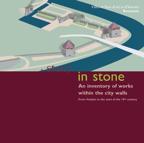
An inventory of works within the city walls - Besançon
An inventory of works within the city walls - Besançon
An inventory of works within the city walls - Besançon

Create successful ePaper yourself
Turn your PDF publications into a flip-book with our unique Google optimized e-Paper software.
Villes et Pays d’art et d’histoire<br />
<strong>Besançon</strong><br />
a story in stone<br />
<strong>An</strong> <strong>inventory</strong> <strong>of</strong> <strong>works</strong><br />
<strong>within</strong> <strong>the</strong> <strong>city</strong> <strong>walls</strong><br />
From Vauban to <strong>the</strong> start <strong>of</strong> <strong>the</strong> 19 th century
A natural stronghold<br />
<strong>Besançon</strong>, from its earliest history, has made <strong>the</strong> most <strong>of</strong><br />
its natural advantages:<br />
- an exceptional defensive site: a loop formed by<br />
a meander in <strong>the</strong> Doubs, closed <strong>of</strong>f by a hill (<strong>the</strong> location<br />
<strong>of</strong> <strong>the</strong> citadel). The site had space for housing and could be<br />
easily defended as it is closed <strong>of</strong>f by <strong>the</strong> citadel rock<br />
(<strong>the</strong> loop was occupied from <strong>the</strong> Bronze Age,<br />
around 1500 B.C., by Gallic tribes)<br />
- A crossroads location between <strong>the</strong> Rhine and Rhone<br />
regions and between nor<strong>the</strong>rn Italy and <strong>the</strong> Seine.<br />
The geographical constraints <strong>the</strong>refore dictated <strong>the</strong><br />
conditions for <strong>the</strong> establishment <strong>of</strong> <strong>the</strong> town.<br />
A military stronghold, political centre and religious capital,<br />
<strong>the</strong> fortifications, erected at every great period in its history,<br />
have shaped <strong>the</strong> current urban landscape.
Vauban and <strong>Besançon</strong><br />
Vauban made best possible use <strong>of</strong><br />
<strong>the</strong> natural defences <strong>of</strong> <strong>the</strong> <strong>Besançon</strong><br />
site, with <strong>the</strong> citadel, <strong>the</strong> masterpiece<br />
among all <strong>the</strong> defence <strong>works</strong> at <strong>the</strong><br />
narrowest and highest point,<br />
<strong>the</strong> right-bank enclosure with Fort<br />
Griffon, bastions and demi-lunes<br />
(ravelins) and an innovative system<br />
on <strong>the</strong> left bank, taking into account<br />
<strong>the</strong> surrounding heights which,<br />
higher than <strong>the</strong> citadel, <strong>of</strong>fered<br />
strategic positions against any<br />
attacker. Adapting <strong>the</strong> <strong>works</strong> on<br />
<strong>the</strong> town site to marvellous effect,<br />
Vauban made <strong>Besançon</strong> into<br />
a defensive bastion against <strong>the</strong><br />
Germanic lands, a role reinforced<br />
fur<strong>the</strong>r in <strong>the</strong> eighteenth century.<br />
Vauban’s <strong>works</strong> at <strong>Besançon</strong> were<br />
completed in three stages:<br />
- between 1675 and 1683 <strong>the</strong> town<br />
was provided with a mighty citadel ;<br />
- between 1675 and 1695, <strong>the</strong><br />
fortifications <strong>of</strong> <strong>the</strong> loop wall and<br />
<strong>the</strong> Battant ring <strong>of</strong> defences<br />
were rebuilt ;<br />
- from 1680 (and into <strong>the</strong> nineteenth<br />
century), barracks were built on<br />
open spaces to <strong>the</strong> east <strong>of</strong> <strong>the</strong> <strong>city</strong>:<br />
<strong>the</strong> Saint-Paul and Saint-Pierre<br />
barracks, to accommodate 1,500<br />
to 2,000 garrisoned soldiers.<br />
After Vauban<br />
In <strong>the</strong> nineteenth century, constant<br />
progress in artillery technology,<br />
in particular in <strong>the</strong> use <strong>of</strong> canons with<br />
rifled barrels and shells, considerably<br />
increased <strong>the</strong> effectiveness <strong>of</strong> artillery<br />
and rendered Vauban’s defences<br />
obsolete. A new system <strong>of</strong> defences<br />
would be required to stand up to<br />
<strong>the</strong> increasingly powerful artillery.<br />
The ancient concept <strong>of</strong> siege<br />
warfare in which a town resisted<br />
attack using <strong>the</strong> protection <strong>of</strong> its <strong>walls</strong>,<br />
was succeeded by <strong>the</strong> idea <strong>of</strong> <strong>the</strong><br />
military camp protected by semi-buried<br />
fortifications built on surrounding<br />
high ground: detached forts.<br />
From 1945, <strong>the</strong> development <strong>of</strong><br />
defence policy and techniques having<br />
robbed <strong>the</strong> town <strong>of</strong> its role as<br />
a stronghold on <strong>the</strong> eastern front,<br />
<strong>the</strong> military authority abandoned most<br />
<strong>of</strong> <strong>the</strong> sites situated in <strong>the</strong> loop,<br />
as well as most <strong>of</strong> <strong>the</strong> <strong>works</strong> on <strong>the</strong> ring<br />
<strong>of</strong> defences and <strong>the</strong> barracks.<br />
In 1959, <strong>the</strong> town bought back <strong>the</strong><br />
citadel from <strong>the</strong> army which no<br />
longer had use for it. The military<br />
also transferred to it and to <strong>the</strong><br />
Département, <strong>the</strong> old <strong>city</strong> forts<br />
which <strong>the</strong>n became administrative<br />
or cultural heritage buildings ; those<br />
belonging to <strong>the</strong> <strong>Besançon</strong>'s ring<br />
<strong>of</strong> defences were transferred to <strong>the</strong><br />
neighbouring communities from 1962.<br />
The army now only owns two forts,<br />
at Montfaucon and Montboucons.<br />
Modifications to <strong>the</strong> defence system <strong>of</strong><br />
<strong>the</strong> site in <strong>the</strong> nineteenth and twentieth<br />
centuries have however allowed several<br />
features to survive which bear witness<br />
to <strong>the</strong> grand scale <strong>of</strong> <strong>the</strong> old military<br />
base, due to <strong>the</strong> <strong>works</strong> <strong>of</strong> Vauban.
List <strong>of</strong> <strong>works</strong><br />
The urban ring <strong>of</strong> defences around <strong>Besançon</strong> consists<br />
<strong>of</strong> three units:<br />
- <strong>the</strong> citadel ;<br />
- <strong>the</strong> loop defences ;<br />
- <strong>the</strong> Battant ring <strong>of</strong> defences.<br />
For each work <strong>the</strong> following are mentioned:<br />
its (or <strong>the</strong>ir) main date(s) and location.<br />
Whilst most <strong>of</strong> <strong>the</strong> <strong>works</strong> date from Vauban’s time<br />
(and almost all were modified in <strong>the</strong> nineteenth<br />
century), some (which he reused) date<br />
from before Vauban ; and o<strong>the</strong>rs were built<br />
in <strong>the</strong> nineteenth century.<br />
This list is not exhaustive: it does not mention every<br />
feature <strong>of</strong> curtain <strong>walls</strong>, powder magazines, forward<br />
slopes and underground passages etc…<br />
To create an overview <strong>of</strong> <strong>the</strong> defence <strong>works</strong> presented in<br />
this document, it was necessary to simplify and obtain<br />
an outline <strong>of</strong> <strong>the</strong> <strong>works</strong> as a whole.<br />
The citadel<br />
The citadel<br />
Seventeenth - nineteenth centuries<br />
99, rue des Fusillés de la Résistance<br />
The citadel is one <strong>of</strong> <strong>the</strong> features <strong>of</strong><br />
<strong>the</strong> defence system which is perfectly<br />
consistent with Vauban’s plan<br />
to protect <strong>Besançon</strong> and affirm<br />
<strong>the</strong> power <strong>of</strong> <strong>the</strong> king over <strong>the</strong> town<br />
and <strong>the</strong> province.<br />
Built on <strong>the</strong> summit <strong>of</strong> <strong>the</strong> rock<br />
closing <strong>the</strong> meander <strong>of</strong> <strong>the</strong> river<br />
Doubs, it stretches over twelve hectares<br />
and towers more than one hundred<br />
meters above <strong>the</strong> old town. The rock,<br />
known as Mont Caelius by <strong>the</strong> Romans,<br />
<strong>the</strong>n became Mont Saint-Étienne.<br />
Until 1668, Mont Saint-Étienne was<br />
only occupied by a wall barring it<br />
to <strong>the</strong> south with a fortified gate.<br />
On <strong>the</strong> nor<strong>the</strong>rn side, looking<br />
towards <strong>the</strong> town, <strong>the</strong> church <strong>of</strong><br />
Saint-Étienne* was built with its<br />
cloister and outbuildings as well as <strong>the</strong><br />
canonry <strong>of</strong> <strong>the</strong> Saint-Jean’s ca<strong>the</strong>dral<br />
chapter, situated fur<strong>the</strong>r down.<br />
The citadel was built in several<br />
stages from 1668.<br />
Fortress, barracks, military prison...<br />
<strong>the</strong> citadel fulfilled <strong>the</strong>se various<br />
roles over <strong>the</strong> course <strong>of</strong> <strong>the</strong> centuries.<br />
Acquired by <strong>the</strong> Town in 1959, it has<br />
now been restored as a cultural and<br />
tourist site. It invites <strong>the</strong> visitor to<br />
engage with <strong>the</strong> history <strong>of</strong> people and<br />
various ways <strong>of</strong> life in <strong>the</strong> region.<br />
*<br />
It would seem that at <strong>the</strong> beginning <strong>of</strong><br />
Christianisation, an oratory dedicated to saint Étienne,<br />
first martyr <strong>of</strong> <strong>the</strong> <strong>city</strong>, was erected at <strong>the</strong> foot<br />
<strong>of</strong> <strong>the</strong> hill. This oratory was <strong>the</strong>n replaced by a church<br />
first known as Saint-Étienne, <strong>the</strong>n Saint-Jean and<br />
Saint-Étienne, and finally simply Saint-Jean (now <strong>the</strong><br />
ca<strong>the</strong>dral <strong>of</strong> Saint-Jean). A second church, built<br />
at <strong>the</strong> top <strong>of</strong> <strong>the</strong> hill, completed and embellished in <strong>the</strong><br />
eleventh century, is known simply as Saint-Étienne.
The loop defences<br />
Built on <strong>the</strong> left bank <strong>of</strong> <strong>the</strong> Doubs,<br />
<strong>the</strong>se defence <strong>works</strong> sealed <strong>of</strong>f <strong>the</strong><br />
Doubs from <strong>the</strong> Porte de Malpas<br />
gate to <strong>the</strong> Porte Taillée gate. From<br />
<strong>the</strong> Porte de Malpas gate which<br />
today no longer exists, to <strong>the</strong> Porte<br />
Notre-Dame gate stretches <strong>the</strong><br />
Tarragnoz district. From <strong>the</strong> Porte<br />
Notre-Dame gate, <strong>the</strong> starting point <strong>of</strong><br />
<strong>the</strong> ring <strong>of</strong> defences around <strong>the</strong> town,<br />
on <strong>the</strong> Cordeliers flank, 1,500 metres <strong>of</strong><br />
ramparts dotted with bastioned towers<br />
and bastions protected <strong>the</strong> town. From<br />
<strong>the</strong> Cordeliers flank to <strong>the</strong> Saint-Esprit<br />
bastion, 500 metres <strong>of</strong> quays with<br />
casemates protected <strong>the</strong> bank <strong>of</strong> <strong>the</strong><br />
Doubs. This was a double defence work<br />
at Chamars, protecting an arm <strong>of</strong> <strong>the</strong><br />
Doubs which has now disappeared.<br />
From <strong>the</strong> Saint-Esprit bastion to <strong>the</strong><br />
Porte Rivotte gate, ano<strong>the</strong>r entrance<br />
to <strong>the</strong> town where <strong>the</strong> ring <strong>of</strong> defences<br />
around <strong>the</strong> town is completed with<br />
ano<strong>the</strong>r 1,500 metres <strong>of</strong> ramparts<br />
reinforced by bastions or towers border<br />
on <strong>the</strong> river. The Rivotte district<br />
stretches from <strong>the</strong> Porte Rivotte gate,<br />
<strong>the</strong> town’s real entrance, to <strong>the</strong> Porte<br />
Taillée gate. Porte Notre-Dame and<br />
Porte Rivotte gates are linked to <strong>the</strong><br />
citadel by a fortified circular walkway.<br />
From <strong>the</strong> seventeenth to <strong>the</strong> nineteenth<br />
century, <strong>the</strong> fortifications had <strong>the</strong>ir<br />
« feet in <strong>the</strong> water ». It was <strong>the</strong> building<br />
<strong>of</strong> <strong>the</strong> Canal Monsieur (which would<br />
become <strong>the</strong> Rhone - Rhine Canal) that<br />
modified <strong>the</strong>ir aspect, with <strong>the</strong> creation<br />
<strong>of</strong> <strong>the</strong> towpath at <strong>the</strong> foot <strong>of</strong> <strong>the</strong><br />
ramparts or accessed along <strong>the</strong> Doubs.<br />
Created by Vauban from 1680<br />
onwards, <strong>the</strong>se defences succeeded <strong>the</strong><br />
medieval fortifications restored and<br />
added to by Charles V in <strong>the</strong> sixteenth<br />
century, reusing <strong>the</strong> ancient fortifications<br />
wherever possible. Because he had<br />
led <strong>the</strong> 1674 siege against <strong>the</strong> town,<br />
Vauban knew all its weak points and<br />
was <strong>the</strong>refore in a position to design <strong>the</strong><br />
best possible defence system.<br />
In 1687 he invented <strong>the</strong> bastioned<br />
towers with thick <strong>walls</strong> and two firing<br />
levels. These towers solved <strong>the</strong> problem<br />
<strong>of</strong> domination by <strong>the</strong> neighbouring<br />
heights <strong>of</strong> Bregille and Chaudanne<br />
over <strong>the</strong> town (it was at Bregille and in<br />
particular at Chaudanne that Vauban<br />
had installed his batteries in 1674<br />
to take <strong>the</strong> town and <strong>the</strong> citadel).<br />
Many engineers would work under<br />
Vauban’s command at <strong>Besançon</strong> and<br />
he himself came about twenty times to<br />
supervise <strong>the</strong> town’s fortification <strong>works</strong>.<br />
The building <strong>of</strong> <strong>the</strong> ramparts began<br />
at <strong>the</strong> same time as <strong>the</strong> citadel, and,<br />
scarcely had <strong>the</strong>y been finished<br />
than, <strong>the</strong> town’s ring <strong>of</strong> defences<br />
was being constantly repaired,<br />
improved and modified.
1<br />
Notre-Dame tower<br />
Middle Ages, seventeenth century<br />
Huddersfield-Kirklees roundabout<br />
Also known as <strong>the</strong> Charles V tower<br />
or bastion and sometimes <strong>the</strong> round<br />
tower, it was thought to have been built<br />
between 1546 and 1560 by Charles V<br />
on <strong>the</strong> old medieval defences and was<br />
entirely renovated by Vauban in <strong>the</strong><br />
seventeenth century. A curtain wall<br />
linked it to <strong>the</strong> porte Notre-Dame.<br />
The lower entrance to <strong>the</strong> tower was<br />
walled up at <strong>the</strong> time <strong>of</strong> filling in<br />
<strong>of</strong> <strong>the</strong> bastion courtyard adjacent to<br />
it. The upper level is also walled.<br />
1<br />
2<br />
Ramparts and site <strong>of</strong> <strong>the</strong><br />
old Notre-Dame gate<br />
Seventeenth century<br />
Tarragnoz district<br />
In 1690, Vauban had <strong>the</strong> old porte<br />
Notre-Dame walled up. It was one<br />
<strong>of</strong> <strong>the</strong> entrances to <strong>Besançon</strong>.<br />
Vauban had a new one built by <strong>the</strong><br />
Doubs in 1691. Demolished in 1894, it<br />
was his first fortified work in this part<br />
<strong>of</strong> <strong>the</strong> defences. The curtain wall which<br />
extends up to <strong>the</strong> gare d’eau (wharf,<br />
or literally, « water station ») was built<br />
on one dating from <strong>the</strong> fifteenth century.<br />
The projecting defence work, situated<br />
at <strong>the</strong> brisure (break in direction) <strong>of</strong> <strong>the</strong><br />
curtain wall is known as <strong>the</strong> « double<br />
guérite » (double lookout) 4 . It was<br />
built on <strong>the</strong> base <strong>of</strong> an old fourteenth<br />
century tower and gave as full a view<br />
as possible over <strong>the</strong> surrounding area.<br />
2<br />
3<br />
Porte Notre-Dame bastion<br />
Seventeenth and nineteenth centuries<br />
10, avenue de la Gare d’eau<br />
3<br />
Built between 1675 and 1693,<br />
this bastion was adjacent to <strong>the</strong> porte<br />
Notre-Dame. Its lower part included<br />
a casemate, now walled in and<br />
situated under <strong>the</strong> roadway and<br />
its upper part has a parapet drilled with<br />
murder holes and artillery embrasures.<br />
The guardhouse <strong>of</strong> <strong>the</strong> old portal<br />
is still visible from <strong>the</strong> bastion gorge.
5<br />
Waterstation guardhouse<br />
(Corps de garde de la gare d’eau)<br />
Nineteenth century<br />
Chamars Promenade<br />
It controlled access <strong>of</strong> boats<br />
to <strong>the</strong> water station.<br />
6<br />
Town bastion<br />
Seventeenth and nineteenth centuries<br />
Chamars Promenade<br />
Built in <strong>the</strong> Middle Ages on an islet<br />
on <strong>the</strong> edge <strong>of</strong> <strong>the</strong> river, <strong>the</strong> town mill<br />
was encompassed by Vauban into a<br />
bastion in order to protect it.<br />
In <strong>the</strong> nineteenth century, <strong>the</strong> creation<br />
<strong>of</strong> <strong>the</strong> towpath for <strong>the</strong> Canal Monsieur<br />
rendered its use obsolete . The bastion<br />
was called <strong>the</strong> town mill bastion<br />
and became a real defence work and<br />
became known as <strong>the</strong> town bastion.<br />
7<br />
Chamars bastioned tower<br />
Seventeenth and nineteenth centuries<br />
Chamars Promenade<br />
Remarkable innovations by Vauban,<br />
<strong>the</strong> first bastioned towers flanking<br />
urban defences were built in <strong>Besançon</strong><br />
from 1687. Smaller than <strong>the</strong> bastions,<br />
<strong>the</strong>y have two firing levels. The upper<br />
one, open to <strong>the</strong> skies and <strong>the</strong> lower<br />
one to shelter <strong>the</strong> canons from shots<br />
raining down from <strong>the</strong> neighbouring<br />
high ground. Vauban, keen to protect<br />
<strong>the</strong> people, made <strong>the</strong>se <strong>works</strong> partly<br />
with brick as splinters from such<br />
material caused by canonballs were<br />
less dangerous than splinters <strong>of</strong> stone.<br />
The Chamars bastioned tower was<br />
built on <strong>the</strong> rock, on <strong>the</strong> river bank,<br />
between 1687 and 1691. It was<br />
Vauban’s only tower to have survived<br />
to date approximately as he designed<br />
it. It was covered in <strong>the</strong> nineteenth<br />
century as were <strong>the</strong> o<strong>the</strong>r towers <strong>of</strong><br />
<strong>the</strong> defences encircling <strong>the</strong> town.
8<br />
9<br />
Le Marais bastioned tower<br />
Seventeenth and nineteenth centuries<br />
Chamars Promenade<br />
Built on <strong>the</strong> rock, on <strong>the</strong> river bank<br />
between 1687 and 1691,<br />
it resembled that <strong>of</strong> Chamars. 10<br />
Cordeliers bastioned tower<br />
Archbishop’s bastion<br />
Seventeenth and nineteenth centuries<br />
Chamars Promenade<br />
The archbishop’s mill was constructed<br />
in <strong>the</strong> Middle Ages on <strong>the</strong> arm <strong>of</strong><br />
<strong>the</strong> Doubs dividing Chamars into<br />
two. Vauban encircled it with<br />
his fortifications, surrounding it with<br />
a bastion. Construction <strong>of</strong> <strong>the</strong><br />
Canal Monsieur rendered it obsolete.<br />
Seventeenth and nineteenth centuries<br />
Chamars promenade<br />
The Cordeliers bastioned tower,<br />
also known as <strong>the</strong> hospital bastion<br />
or Canot tower, probably completed<br />
in 1691, is a pentagonal bastioned<br />
tower designed like <strong>the</strong><br />
previous ones which was subject<br />
to <strong>the</strong> same modifications.
13<br />
11<br />
Quai Vauban<br />
Seventeenth century<br />
The <strong>works</strong> on <strong>the</strong> quay on ei<strong>the</strong>r<br />
side <strong>of</strong> <strong>the</strong> porte Battant, on <strong>the</strong> side<br />
<strong>of</strong> <strong>the</strong> loop, started in 1691 under<br />
<strong>the</strong> supervision <strong>of</strong> engineer Isaac<br />
Robelin, director <strong>of</strong> <strong>the</strong> Franche-Comté<br />
fortifications, against <strong>the</strong> advice <strong>of</strong><br />
Vauban who only wanted<br />
to build a simple rampart. The<br />
project, which involved realigning<br />
<strong>the</strong> façades <strong>of</strong> <strong>the</strong> houses, would<br />
never be completed due to lack <strong>of</strong><br />
funds. To celebrate <strong>the</strong> glory <strong>of</strong> Louis<br />
XIV, a triumphal arch was erected on<br />
<strong>the</strong> bridge between 1691 and 1693.<br />
The base <strong>of</strong> <strong>the</strong> gate had a defensive<br />
function: two batteries with casemates<br />
were <strong>the</strong>re for firing upstream and<br />
downstream and to prevent <strong>the</strong> Doubs<br />
from being crossed. In poor condition,<br />
<strong>the</strong> arch was knocked in 1776.<br />
Cordeliers flank casemate<br />
Seventeenth century<br />
Chamars Promenade / Quai Vauban<br />
The Cordeliers flank is a reinforced<br />
vaulted artillery-pro<strong>of</strong> casemate<br />
for three pieces <strong>of</strong> artillery which<br />
could aim low fire over <strong>the</strong> Doubs,<br />
between <strong>the</strong> Cordeliers tower and <strong>the</strong><br />
Arenes bastion situated on <strong>the</strong> o<strong>the</strong>r<br />
bank. The entrance is no longer visible<br />
as <strong>the</strong> buildings <strong>of</strong> <strong>the</strong> Lycée Pasteur<br />
school are in front <strong>of</strong> it: perhaps <strong>the</strong><br />
entrance to <strong>the</strong> casemate has been<br />
buried under <strong>the</strong>se buildings or under<br />
<strong>the</strong> embankment next to <strong>the</strong> road.<br />
Casemate on <strong>the</strong> Poitune flank<br />
12<br />
Seventeenth century<br />
Quai Vauban (entrance at <strong>the</strong> corner <strong>of</strong> <strong>the</strong><br />
rue du Lycée and <strong>the</strong> rue Claude Pouillet<br />
is currently occupied by a restaurant)<br />
12<br />
Saint-Esprit bastion<br />
14<br />
Seventeenth century<br />
Corner <strong>of</strong> Quai Vauban/rue Jean Petit<br />
This was built between 1692 and 1695<br />
and levelled in 1895. In its left flank<br />
<strong>the</strong>re is a casemate which had two<br />
pieces <strong>of</strong> artillery for directing low<br />
fire over <strong>the</strong> Doubs downstream.<br />
Its right-hand flank included<br />
a slope down to a watering place.<br />
This was a vaulted passage in <strong>the</strong><br />
ramparts which enabled horses to be<br />
taken to drink <strong>the</strong> river water.<br />
The passage was equipped with a<br />
firing arcade and was closed by gates.<br />
14<br />
This casemate had <strong>the</strong> same<br />
function as <strong>the</strong> Cordeliers casemate,<br />
but only had two canons.<br />
11
16<br />
16<br />
15<br />
15<br />
Ruins <strong>of</strong> <strong>the</strong> Saint-Pierre<br />
bastioned tower<br />
Levelled ramparts<br />
Twentieth century<br />
Seventeenth and nineteenth centuries.<br />
Avenue Élisée Cusenier<br />
Marché-Beaux-Arts underground car park,<br />
Charlotte square and car park,<br />
Avenue Élisée Cusenier<br />
Only <strong>the</strong> bottom <strong>of</strong> <strong>the</strong> face and<br />
right-hand flank <strong>of</strong> <strong>the</strong> Saint-Pierre<br />
bastioned tower, built between 1687<br />
and 1690 are still visible. In <strong>the</strong><br />
eighteenth century, <strong>the</strong> tower became<br />
a gunpowder magazine ; it was <strong>the</strong>n<br />
ro<strong>of</strong>ed in lauzes (flat stones). Levelled<br />
between 1895 and 1897, toge<strong>the</strong>r<br />
with <strong>the</strong> rampart which was built<br />
before it, it is <strong>the</strong> only one <strong>of</strong> <strong>the</strong> six<br />
bastioned towers that were destroyed.<br />
The Saint-Esprit bastion is <strong>the</strong> start<br />
<strong>of</strong> what are now known as <strong>the</strong><br />
« levelled ramparts ». At <strong>the</strong> end<br />
<strong>of</strong> <strong>the</strong> nineteenth century, after<br />
dismantling <strong>the</strong> urban defences,<br />
<strong>the</strong> Town levelled part <strong>of</strong> its <strong>walls</strong>,<br />
from <strong>the</strong> Bastion du Saint-Esprit<br />
through to <strong>the</strong> bastioned<br />
Saint-Pierre tower . Demolition<br />
<strong>works</strong> were carried out<br />
between 1895 and 1897.<br />
17<br />
Saint-Paul mill bastion<br />
17<br />
Seventeenth and nineteenth centuries<br />
Avenue Arthur Gaulard<br />
The mill <strong>of</strong> Saint-Paul abbey straddled<br />
an arm <strong>of</strong> <strong>the</strong> Doubs. Around 1689,<br />
Vauban surrounded it with a bastion.<br />
In <strong>the</strong> nineteenth century,<br />
<strong>the</strong> completion <strong>of</strong> <strong>the</strong> Canal Monsieur<br />
with its towpath which follows<br />
<strong>the</strong> course <strong>of</strong> <strong>the</strong> riverbank and<br />
<strong>the</strong> loop required <strong>the</strong> demolition <strong>of</strong><br />
<strong>the</strong> Saint-Paul mill. A sluice gate was<br />
<strong>the</strong>n created at <strong>the</strong> site <strong>of</strong> <strong>the</strong> mill races<br />
(channels in which paddle wheels are<br />
situated). These were moved under<br />
<strong>the</strong> flanks <strong>of</strong> <strong>the</strong> bastion where <strong>the</strong>y<br />
can still be seen. A flour mill which<br />
supplied flour to <strong>the</strong> entire garrison<br />
until <strong>the</strong> middle <strong>of</strong> <strong>the</strong> twentieth<br />
century was <strong>the</strong>n built above it.
Footbridge<br />
25<br />
26<br />
27<br />
24<br />
29<br />
28<br />
23<br />
16<br />
15<br />
17<br />
Republi
c bridge<br />
14<br />
22<br />
Bregille bridge<br />
Battant bridge<br />
13<br />
Bregille<br />
18<br />
Railway bridge<br />
12<br />
19<br />
11
21<br />
20<br />
10<br />
The Citadel<br />
Canot bridge<br />
1<br />
9<br />
2<br />
3<br />
5<br />
4
Charles de Gaulle<br />
bridge<br />
6<br />
8<br />
The loop defences Battant defences<br />
1<br />
2<br />
3<br />
4<br />
5<br />
6<br />
7<br />
8<br />
9<br />
10<br />
Notre-Dame tower<br />
Ramparts and site <strong>of</strong> <strong>the</strong> old<br />
Notre-Dame gate<br />
Porte Notre-Dame bastion<br />
Double guérite (double lookout)<br />
Waterstation guardhouse<br />
Town bastion<br />
Chamars bastioned tower<br />
Le Marais bastioned tower<br />
Archbishop’s bastion<br />
Cordeliers bastioned tower<br />
11<br />
12<br />
13<br />
14<br />
15<br />
16<br />
17<br />
18<br />
19<br />
20<br />
Cordeliers flank casemate<br />
Casemate on <strong>the</strong> Poitune flank<br />
Quai Vauban<br />
Saint-Esprit bastion<br />
Levelled ramparts<br />
Ruins <strong>of</strong> <strong>the</strong> Saint-Pierre bastioned tower<br />
Saint-Paul mill bastion<br />
Bregille bastioned tower<br />
7<br />
Rivotte bastioned tower<br />
Porte Rivotte gate<br />
Chaudanne<br />
21<br />
22<br />
23<br />
24<br />
25<br />
26<br />
27<br />
28<br />
29<br />
Arènes bastion<br />
Charmont bastion<br />
Charmont demi-lune<br />
Fort Griffon<br />
Battant demi-lune and guardhouse<br />
Battant bastion<br />
Montmart tower<br />
Pelote tower<br />
Pelote counterguard
18<br />
18<br />
Bregille bastioned tower<br />
Seventeenth and nineteenth centuries<br />
Avenue Arthur Gaulard<br />
Built between 1687 and 1689,<br />
it is <strong>the</strong> only bastioned tower to be<br />
built entirely <strong>of</strong> stone and had an<br />
annular vault on a central pillar,<br />
containing a well. It had to provide<br />
flanking for <strong>the</strong> Rivotte tower<br />
and also had a defensive role for<br />
<strong>the</strong> Saint-Paul mill. At <strong>the</strong> end <strong>of</strong><br />
<strong>the</strong> nineteenth century, it was converted<br />
to a military dovecote, which would<br />
continue to be used until 1920.<br />
19<br />
19<br />
Rivotte bastioned tower<br />
Seventeenth and nineteenth centuries<br />
Avenue Arthur Gaulard<br />
The Rivotte bastioned tower was built<br />
between 1687 and 1690. Its foundations<br />
were built on <strong>the</strong> rock, on <strong>the</strong> bank <strong>of</strong><br />
<strong>the</strong> river and <strong>the</strong> ditch situated in front<br />
between <strong>the</strong> Doubs and <strong>the</strong> citadel hill,<br />
was filled with water. The rampart was<br />
modified when <strong>the</strong> <strong>Besançon</strong> - Le Locle<br />
railway line was built at <strong>the</strong> end <strong>of</strong> <strong>the</strong><br />
nineteenth century, <strong>the</strong>n again, when <strong>the</strong><br />
river port was modified in 1938.<br />
Like <strong>the</strong> Bregille bastioned tower,<br />
it has a circular vault on a central pillar<br />
containing a well. This well formed a<br />
link with <strong>the</strong> upper-floor platform,<br />
for <strong>the</strong> passage <strong>of</strong> personnel and<br />
equipment. In <strong>the</strong> nineteenth century,<br />
when <strong>the</strong> ro<strong>of</strong> was built, this well was<br />
opened up in order to collect rainwater.<br />
20<br />
20<br />
Porte Rivotte gate<br />
Middle Ages<br />
Rue Rivotte<br />
Created in <strong>the</strong> Middle Ages in <strong>the</strong><br />
wall built along <strong>the</strong> river, <strong>the</strong> Porte<br />
Rivotte gate guarded <strong>the</strong> passage<br />
between <strong>the</strong> Doubs and <strong>the</strong> citadel<br />
rock to protect <strong>the</strong> town. In <strong>the</strong> first<br />
half <strong>of</strong> <strong>the</strong> sixteenth century, on <strong>the</strong><br />
initiative <strong>of</strong> Emperor Charles V,<br />
<strong>the</strong> municipal authorities streng<strong>the</strong>ned<br />
<strong>the</strong> fortifications <strong>of</strong> <strong>the</strong> loop. The Porte<br />
Rivotte gate was <strong>the</strong>n widened and<br />
a drawbridge installed between <strong>the</strong><br />
two conical-ro<strong>of</strong>ed towers. After<br />
<strong>the</strong> French conquest, its central part<br />
was reconstructed. The façade is still<br />
decorated with <strong>the</strong> royal sun, emblem<br />
<strong>of</strong> Louis XIV. A new modification,<br />
in 1893, entailed removal <strong>of</strong> <strong>the</strong><br />
drawbridge and <strong>the</strong> portcullis, filling<br />
in <strong>of</strong> <strong>the</strong> ditches on <strong>the</strong> town side,<br />
destruction <strong>of</strong> <strong>the</strong> building <strong>of</strong> <strong>the</strong><br />
town and building <strong>of</strong> walkways<br />
through <strong>the</strong> towers. With <strong>the</strong> porte<br />
Taillée*, fur<strong>the</strong>r up <strong>the</strong> route de la<br />
Suisse, <strong>the</strong> Porte Rivotte gate is <strong>the</strong><br />
last <strong>of</strong> <strong>the</strong> town’s fortified entrances.<br />
* Originally, Mont Saint-Étienne, on which <strong>the</strong> citadel<br />
was built went straight down to <strong>the</strong> river. It was not<br />
until <strong>the</strong> ninth and tenth centuries that an access<br />
road was built towards <strong>the</strong> district with a fortified<br />
gate, <strong>the</strong> porte Taillée. The latter was widened in<br />
<strong>the</strong> tenth century to enable access <strong>of</strong> pedestrians,<br />
cavalry and carriages <strong>the</strong>n was modified several<br />
times over <strong>the</strong> course <strong>of</strong> <strong>the</strong> centuries. It was<br />
a first line <strong>of</strong> defence, <strong>the</strong> real gate being <strong>the</strong><br />
Porte Rivotte gate, an opening in <strong>the</strong> wall <strong>of</strong> <strong>the</strong><br />
fortifications surrounding <strong>the</strong> loop in <strong>the</strong> river Doubs.
Battant defences<br />
The Battant fortifications were created<br />
between 1677 and 1688. From 1677,<br />
<strong>the</strong> defences were planned by engineer<br />
Montille in accordance with Vauban’s<br />
designs. Situated on <strong>the</strong> right bank<br />
<strong>of</strong> <strong>the</strong> Doubs, <strong>the</strong>y surround <strong>the</strong><br />
Battant* district from Arènes<br />
as far as <strong>the</strong> Pelote tower near <strong>the</strong><br />
Mouillère stream. The ground rises<br />
in a slope from <strong>the</strong> river, at an<br />
altitude <strong>of</strong> 238 metres up to<br />
<strong>the</strong> Battant heights which peak at an<br />
altitude <strong>of</strong> 280 metres. The highest<br />
point is Fort Griffon, which Vauban<br />
decided to build in 1680 and which<br />
might be considered as a second citadel.<br />
The Battant ring <strong>of</strong> defences has three<br />
entrance gates each protected by<br />
a bastion and a demi-lune ; a forward<br />
slope stretched out in front <strong>of</strong> <strong>the</strong><br />
defence <strong>works</strong>. The great <strong>works</strong> carried<br />
out at <strong>the</strong> end <strong>of</strong> <strong>the</strong> nineteenth century<br />
and <strong>the</strong> beginning <strong>of</strong> <strong>the</strong> twentieth<br />
century modified this unit. Nowadays,<br />
<strong>the</strong> gates have disappeared, parts<br />
<strong>of</strong> <strong>the</strong> ramparts have been replaced<br />
by <strong>the</strong> carriageway and <strong>the</strong> ditches<br />
have become roads or car parks.<br />
*<br />
Before <strong>the</strong> quays were built, <strong>the</strong> rue Battant gave<br />
access from <strong>the</strong> Battant bridge to <strong>the</strong> Mouillère<br />
spring, <strong>the</strong> stream which flows into <strong>the</strong> Doubs<br />
near to <strong>the</strong> Pelote tower. This stream worked<br />
a battoir, or battant - a fulling mill - which gave<br />
its name to <strong>the</strong> road, <strong>the</strong>n to <strong>the</strong> district.<br />
In days gone by, restricted to <strong>the</strong> section on <strong>the</strong> o<strong>the</strong>r<br />
side <strong>of</strong> <strong>the</strong> rues Battant and du Petit Battant, this name<br />
now refers to <strong>the</strong> entire old district situated on <strong>the</strong><br />
right bank <strong>of</strong> <strong>the</strong> Doubs, which is <strong>the</strong> meeting point <strong>of</strong><br />
<strong>the</strong> ancient quarters <strong>of</strong> Battant, Charmont and Arènes.<br />
Arènes bastion<br />
21<br />
Seventeenth and nineteenth centuries<br />
Rue d’Arènes<br />
22<br />
The bastion d’Arènes marks <strong>the</strong><br />
start <strong>of</strong> <strong>the</strong> wall around <strong>the</strong> Battant<br />
district, situated on <strong>the</strong> right bank <strong>of</strong><br />
<strong>the</strong> Doubs. In <strong>the</strong> nineteenth century,<br />
this work was significantly restored,<br />
in particular when <strong>the</strong> rues d’Arènes<br />
and de Port Citeaux as well as <strong>the</strong><br />
quai Veil Picard were built. At <strong>the</strong><br />
time <strong>of</strong> <strong>the</strong> construction <strong>of</strong> <strong>the</strong> quay,<br />
<strong>the</strong> military built gates equipped with<br />
drawbridges. No longer in existence,<br />
<strong>the</strong>y served to isolate <strong>the</strong> town, in<br />
particular in <strong>the</strong> evening at curfew time.<br />
Charmont bastion<br />
Seventeenth and nineteenth centuries<br />
Avenue Charles Siffert<br />
The Charmont bastion was built<br />
on a part <strong>of</strong> <strong>the</strong> old medieval wall.<br />
The porte de Charmont, built in <strong>the</strong><br />
fourteenth century and modified in<br />
<strong>the</strong> fifteenth century under Charles V,<br />
was completed with <strong>the</strong> building <strong>of</strong><br />
an artillery bulwark. Vauban did<br />
not have <strong>the</strong> gate demolished and<br />
blocked up, but cleverly used it, as<br />
an underground passage under <strong>the</strong><br />
bastion. In <strong>the</strong> twentieth century, during<br />
town restructuring <strong>works</strong>, <strong>the</strong> bastion<br />
was significantly altered and vestiges <strong>of</strong><br />
<strong>the</strong> medieval gate could be excavated.
Charmont demi-lune<br />
Built between 1677 and 1679,<br />
it was restored in <strong>the</strong> nineteenth and<br />
<strong>the</strong> twentieth centuries at <strong>the</strong> time <strong>of</strong><br />
<strong>the</strong> road improvements. It protected<br />
<strong>the</strong> porte de Charmont which was<br />
destroyed in 1894 and gave access<br />
to <strong>the</strong> town.<br />
Fort Griffon<br />
23 24<br />
Seventeenth and nineteenth centuries<br />
Seventeenth and nineteenth centuries<br />
Avenue de la Paix<br />
Place Griffon<br />
24<br />
The current fort was built as from 1680<br />
on Vauban’s plans. It succeeded a first<br />
bastion which might have been built<br />
in 1595 by Italian engineer Jean<br />
Griffoni, when <strong>the</strong> troops <strong>of</strong> <strong>the</strong> king<br />
<strong>of</strong> France Henry IV were threatening<br />
to lay siege to <strong>Besançon</strong>. This fort,<br />
<strong>the</strong> town’s bridgehead, which occupied<br />
a prime location, might be considered<br />
a second citadel. It served <strong>the</strong> function<br />
<strong>of</strong> a redoubt holding a key position<br />
on <strong>the</strong> right bank and its design enabled<br />
firing both out into <strong>the</strong> countryside in<br />
<strong>the</strong> event <strong>of</strong> attack, and over <strong>the</strong> <strong>city</strong> in<br />
<strong>the</strong> event <strong>of</strong> an uprising « It alone, with<br />
a garrison <strong>of</strong> just 200 men would better<br />
contain <strong>the</strong> population than 1200<br />
accommodated in ordinary barracks. »<br />
23<br />
wrote Vauban. With three bastions<br />
one with a cavalier. It had an entrance<br />
gate which, up to <strong>the</strong> beginning <strong>of</strong> <strong>the</strong><br />
twentieth century, was protected by a<br />
ditch, now filled in, and equipped with<br />
a drawbridge. The courtyard in which<br />
<strong>the</strong> chapel was built is surrounded<br />
by three ranges <strong>of</strong> buildings. Two <strong>of</strong><br />
<strong>the</strong>m are barracks built in accordance<br />
with <strong>the</strong> modular barracks prototype,<br />
Vauban style, <strong>the</strong> second included<br />
<strong>the</strong> guardhouse as well as <strong>the</strong> fort<br />
commander’s accommodation.<br />
Designed to accommodate <strong>the</strong><br />
troops, Fort Griffon was used by <strong>the</strong><br />
military until 1945 <strong>the</strong>n from 1946<br />
it was used as a school. It is now<br />
one <strong>of</strong> <strong>the</strong> buildings <strong>of</strong> <strong>the</strong> Teacher<br />
Training University Institute <strong>of</strong><br />
Franche-Comté. Fort Griffon was listed<br />
as a historical monument in 1944.<br />
22
25<br />
Battant demi-lune<br />
and guardhouse<br />
Seventeenth and nineteenth centuries<br />
Avenue de la Paix, rue des Glacis,<br />
Avenue Edgar Faure<br />
The Battant demi-lune, built between<br />
1677 and 1688, gave access to <strong>the</strong> town<br />
and protected <strong>the</strong> porte Battant which<br />
no longer exists. Restored, <strong>the</strong> two<br />
guardhouses date from <strong>the</strong> seventeenth<br />
and nineteenth centuries respectively.<br />
26<br />
Battant bastion<br />
Seventeenth and nineteenth centuries<br />
Rue Battant, avenue Edgar Faure,<br />
Avenue du maréchal Leclerc<br />
This was probably built from 1677<br />
onwards. Its right-hand flank has a<br />
lower flank and its left-hand flank<br />
adjoined <strong>the</strong> Battant curtain wall,<br />
which no longer exists. Its left-hand<br />
side was equipped with a walkway<br />
which linked it to <strong>the</strong> glacis or forward<br />
slope. The entire parapet was levelled<br />
to <strong>the</strong> height <strong>of</strong> <strong>the</strong> cordon and <strong>the</strong><br />
entire defence <strong>works</strong> are now a public<br />
park and children’s play area.<br />
25<br />
26<br />
27<br />
29
Montmart tower<br />
Pelote tower<br />
27 28 29<br />
Thirteenth century<br />
Fifteenth and seventeenth centuries<br />
Above <strong>the</strong> Battant rise<br />
Quai de Strasbourg<br />
Also known as <strong>the</strong> square tower,<br />
it is at <strong>the</strong> centre <strong>of</strong> <strong>the</strong> Battant bastion.<br />
Probably built in <strong>the</strong> thirteenth century,<br />
it was part <strong>of</strong> <strong>the</strong> medieval porte de<br />
Battant. Vauban included it in <strong>the</strong><br />
Battant cavalier and converted into<br />
a powder store. In <strong>the</strong> nineteenth<br />
century, when <strong>the</strong> bastion cavalier was<br />
razed to <strong>the</strong> ground, <strong>the</strong> tower survived.<br />
28<br />
In <strong>the</strong> twelfth century <strong>the</strong> town<br />
consisted <strong>of</strong> two distinct districts:<br />
<strong>the</strong> ecclesiastical quarter on <strong>the</strong> slopes<br />
<strong>of</strong> <strong>the</strong> hill and <strong>the</strong> entire loop protected<br />
by <strong>the</strong> river, as well as <strong>the</strong> quarter on<br />
<strong>the</strong> right bank <strong>of</strong> <strong>the</strong> Doubs – what<br />
is known now as <strong>the</strong> quartier Battant<br />
(<strong>the</strong> Battant district) – closed <strong>of</strong>f by a<br />
defence work. In <strong>the</strong> thirteenth century,<br />
new ramparts doubled all <strong>the</strong>se lines<br />
<strong>of</strong> defence and were accompanied by<br />
a wall with about ten access portals.<br />
In <strong>the</strong> fifteenth century, <strong>the</strong> emergence <strong>of</strong><br />
fire arms necessitated <strong>the</strong> streng<strong>the</strong>ning<br />
<strong>of</strong> <strong>the</strong> fortifications. In 1475, major<br />
<strong>works</strong> were undertaken near<br />
<strong>the</strong> porte de Battant, with <strong>the</strong><br />
construction <strong>of</strong> <strong>the</strong> « tour neuve de la<br />
Pillotte » (<strong>the</strong> new Pillotte tower) which<br />
may have derived its name from <strong>the</strong><br />
Pillot family from whom <strong>the</strong> land was<br />
purchased.<br />
After <strong>the</strong> French conquest, Vauban,<br />
commissioned to renovate <strong>the</strong> town’s<br />
fortifications, kept <strong>the</strong> Pelote tower<br />
and integrated it into his ramparts. The<br />
Pelote tower was listed as a Historical<br />
Monument in 1942.<br />
Pelote counterguard<br />
Seventeenth century<br />
Quai de Strasbourg<br />
Built between 1677 and 1688, it served<br />
to protect <strong>the</strong> tower and increase its<br />
firing line by doubling it. This is a<br />
trapezoidal work, <strong>the</strong> gorge <strong>of</strong> which is<br />
parallel to <strong>the</strong> Mouillère gully.
Chaudanne fort
Chaudanne hill<br />
In 1674, Vauban installed several<br />
batteries on Chaudanne hill in order to<br />
lay siege to <strong>the</strong> <strong>city</strong>. However, after<br />
<strong>the</strong> conquest he vehemently opposed<br />
<strong>the</strong> construction <strong>of</strong> a fort at Chaudanne<br />
which, being on a higher level, would<br />
pose a threat to <strong>the</strong> citadel.<br />
The development <strong>of</strong> artillery<br />
necessitated <strong>the</strong> building <strong>of</strong> new forts<br />
around <strong>the</strong> town and <strong>the</strong> current<br />
fort was built between 1841 and<br />
1845. It was <strong>the</strong>n part <strong>of</strong> <strong>the</strong> series <strong>of</strong><br />
fortifications designed to protect <strong>the</strong><br />
town. In 1944, it was <strong>the</strong> scene<br />
<strong>of</strong> violent confrontation between<br />
German soldiers and those <strong>of</strong> <strong>the</strong><br />
seventh US infantry regiment which<br />
liberated it on 7th Bregille and Beauregard <strong>of</strong> forts and hills<br />
September. The<br />
In 1674, Louis XIV and his retinue<br />
set up camp on Beauregard Hill to join<br />
<strong>the</strong> attack on <strong>the</strong> citadel. Subsequently<br />
artillery advances necessitated<br />
modification <strong>of</strong> <strong>the</strong> site.<br />
In 1791, a lunette d’Arçon - a small<br />
defence work - was built on <strong>the</strong> hill.<br />
It was transformed into a fort between<br />
1845 and 1870. Polygonal in outline in<br />
order better to adapt to <strong>the</strong> small site,<br />
this work is <strong>the</strong> only one <strong>of</strong> its kind<br />
in <strong>Besançon</strong>.<br />
Designed to protect <strong>the</strong> fort <strong>of</strong> Bregille<br />
to <strong>the</strong> north, it also protected part <strong>of</strong> <strong>the</strong><br />
town ramparts on <strong>the</strong> left bank and <strong>the</strong><br />
Battant bridgehead on <strong>the</strong> right bank.<br />
In 1674, at <strong>the</strong> time <strong>of</strong> <strong>the</strong> conquest,<br />
Vauban had installed on <strong>the</strong> Bregille<br />
hill some artillery pieces with which to<br />
bombard <strong>the</strong> <strong>city</strong>.<br />
The 1814 siege made clear <strong>the</strong> necessity<br />
<strong>of</strong> occupying <strong>the</strong> summit <strong>of</strong> <strong>the</strong> hill to<br />
enlarge <strong>the</strong> defensive perimeter <strong>of</strong> <strong>the</strong><br />
town and <strong>the</strong> current fort was built<br />
between 1820 and 1832.
Glossary<br />
Artillery bulwark<br />
a generic term referring to any work<br />
designed to carry artillery added in front<br />
<strong>of</strong> an older fortification which had not<br />
been designed for <strong>the</strong> firing <strong>of</strong> canons.<br />
Bastion<br />
in principle in modern fortifications,<br />
a low pentagonal work projecting<br />
from a wall. The bastion has five<br />
sides: two faces, two flanks and <strong>the</strong><br />
gorge. It may however differ slightly<br />
when it is based on a previous<br />
work (a bulwark, for example).<br />
Bastioned tower<br />
pentagonal tower with <strong>the</strong><br />
function <strong>of</strong> a bastion.<br />
Vauban designed this for <strong>the</strong><br />
<strong>Besançon</strong> site in order to adapt to<br />
<strong>the</strong> constraints <strong>of</strong> <strong>the</strong> terrain.<br />
Casemate<br />
a vaulted artillery-pro<strong>of</strong> gun chamber.<br />
The casemate designed to serve as<br />
a gun emplacement (known as an<br />
« active casemate ») contained<br />
a ventilation system for <strong>the</strong> evacuation<br />
<strong>of</strong> fumes from <strong>the</strong> firing.<br />
Cavalier<br />
a raised earthwork intended to receive<br />
artillery, raised above ano<strong>the</strong>r work or<br />
above <strong>the</strong> curtains <strong>of</strong> <strong>the</strong> body <strong>of</strong> <strong>the</strong><br />
fortification to double its firing range.<br />
Citadel<br />
fort or fortress commanding a town,<br />
<strong>of</strong>ten straddling its wall, and more<br />
rarely inside it. The citadel <strong>of</strong>ten served<br />
as an arsenal and barracks, and possibly<br />
as a redoubt (work constructed inside<br />
ano<strong>the</strong>r where refuge can be taken<br />
to extend resistance). Its function<br />
was to survey <strong>the</strong> town itself as well<br />
as <strong>the</strong> surrounding countryside.<br />
Cordon<br />
semi-circular projection emphasising<br />
<strong>the</strong> junction <strong>of</strong> <strong>the</strong> embankment scarp<br />
and <strong>the</strong> parapet. The cordon indicates<br />
<strong>the</strong> magistral line, an imaginary line<br />
followed by <strong>the</strong> crown <strong>of</strong> <strong>the</strong> scarp.<br />
Everything below <strong>the</strong> cordon is covered<br />
from <strong>the</strong> view <strong>of</strong> <strong>the</strong> attacker.<br />
Counterguard<br />
low outer work protecting at a distance<br />
<strong>the</strong> faces <strong>of</strong> a bastion or a bastioned<br />
tower while doubling <strong>the</strong> line <strong>of</strong> fire.<br />
Curtain<br />
section <strong>of</strong> wall between two<br />
towers or two bastions.<br />
Demi-lune/ravelin<br />
protected out<strong>works</strong> beyond <strong>the</strong><br />
curtain <strong>of</strong> a bastioned front and<br />
generally circled by its own ditch.<br />
The demi-lune consists <strong>of</strong> two faces<br />
at an angle and a gorge, but may<br />
also have flanks. It <strong>of</strong>ten served to<br />
protect an entrance to <strong>the</strong> site.<br />
Fort<br />
stronghold containing a garrison<br />
and serving to support <strong>the</strong> defensive<br />
system <strong>of</strong> a frontier or town.<br />
Glacis<br />
inclined area extending in front <strong>of</strong><br />
a fortification.<br />
Gorge<br />
part <strong>of</strong> a work placed to <strong>the</strong><br />
least exposed side, towards<br />
<strong>the</strong> inside <strong>of</strong> <strong>the</strong> site.<br />
Guardhouse<br />
a lodge for <strong>the</strong> guarding soldiers.
Guérite (lookout)<br />
small tower projecting from a wall<br />
serving as a lookout and guard post.<br />
Lower flank<br />
work attached to <strong>the</strong> flank <strong>of</strong> <strong>the</strong><br />
bastion to correct a slope that<br />
is too steep.<br />
Lunette<br />
advanced work <strong>of</strong> <strong>the</strong> same shape<br />
as a demi-lune but not integrated<br />
into a bastioned front.<br />
Parapet<br />
wall or embankment enabling defenders<br />
<strong>of</strong> a fortification to shoot from a<br />
point covered from enemy fire.<br />
Rampart<br />
raised defensive earthwork <strong>of</strong>ten<br />
retained by timbers or a retaining<br />
wall (revêtement). The earthwork is<br />
<strong>the</strong> upper platform <strong>of</strong> <strong>the</strong> rampart<br />
serving as a defensive walkway.<br />
Reinforced vault<br />
comprising a vault enabling<br />
resistance to bombardment.<br />
Exploring<br />
<strong>the</strong> fortifications<br />
on foot<br />
many circuits are possible ;<br />
a wide range <strong>of</strong> <strong>the</strong>med visits<br />
<strong>the</strong> citadel, <strong>the</strong> bastioned towers,<br />
Fort Griffon, pedestrian walks around<br />
<strong>the</strong> forts etc. accompanied by an approved<br />
<strong>Besançon</strong> Ville d’art et d’histoire<br />
(<strong>Besançon</strong> Town <strong>of</strong> Art and History)<br />
guide, approximately 2 hours<br />
for each visit, 4 hours for walks.<br />
by boat<br />
The fortifications along <strong>the</strong> water’s edge<br />
guided tour conducted by an approved<br />
<strong>Besançon</strong> Ville d’art et d’histoire<br />
(<strong>Besançon</strong> Town <strong>of</strong> Art and History)<br />
guide, approximately 1 hour 15 minutes<br />
by bicycle<br />
On <strong>the</strong> Eurovéloroute (Euro-cycle route)<br />
(Eurovélo 6 Atlantique-Mer Noire)<br />
also<br />
by coach, on roller skates, taxi or by plane<br />
For all information on visits<br />
and walks, please contact:<br />
Office de tourisme et<br />
des congrès de <strong>Besançon</strong><br />
2, place de la 1 ère Armée Française<br />
25000 <strong>Besançon</strong> - France<br />
Tel. +33(0)3 81 80 92 55<br />
Fax +33(0)3 81 80 58 30<br />
www.besancon-tourisme.com<br />
info@besancon-tourisme.com
In 2007, France submitted <strong>the</strong> <strong>works</strong><br />
<strong>of</strong> Vauban for classification as a Unesco<br />
world heritage site.<br />
Document produced by<br />
<strong>the</strong> Town <strong>of</strong> <strong>Besançon</strong><br />
heritage department<br />
(service du Patrimoine)<br />
December 2007<br />
Texts<br />
Marie-Hélène Bloch,<br />
with <strong>the</strong> assistance <strong>of</strong> Roland Bois<br />
Model and illustrations<br />
Guillaume Bertrand, <strong>Besançon</strong><br />
(based on <strong>the</strong> geographical chart<br />
drawn up by: LM Communiquer)<br />
Translations<br />
Juralangues<br />
www.juralangues.com<br />
www.besancon.fr